Origins of navigation in the Mediterranean Sea seem to be in the birth of the humanization process of the Mediterranean Basin, where ports and colonies or cities were strongly linked and supported this process.
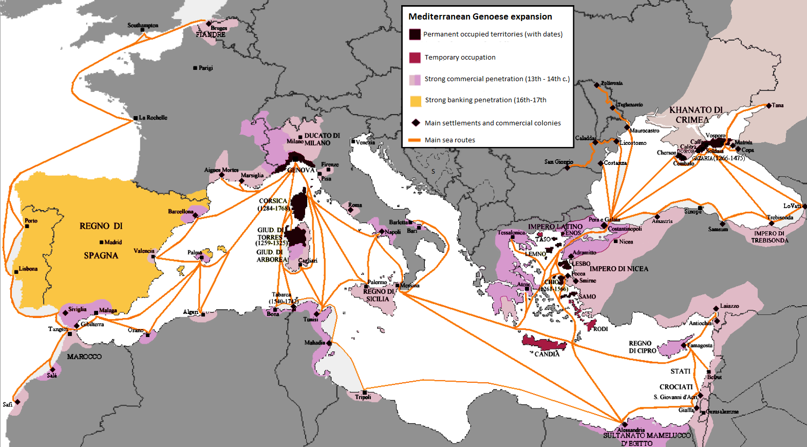
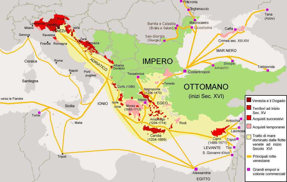
Economy and competitiveness were in the origins of this littoral urbanization, since economy cannot be historically understood, without since competitive spirit. The contemporary vision of this phenomenon includes other parallel concepts, like territorial branding and territorial marketing but they keep the essences of the first times. Fights between Genoa and Venice on Cypriot lands can only be understood from the economic perspective. Territorial controls and urban shapes were related to these facts (Fig. 1-2).
Nowadays, cities need to position themselves competitively within a global scale. These facts imply a double vision of the problem: On the one hand many global cities and towns have experienced unprecedented economic, social, and spatial structural changes. On the other side, these processes are accompanied by an ever growing importance process of branding in territorial and urban expansions.
Image/reputation of the cities, as well as their perceptions from the outset, is a concept strongly linked to the examination of branding. Port cities, and more specifically the urban waterfronts of the cities, are not alien to these phenomena.
The urbanization of the Mediterranean coasts started with strong links with the new colonies and ports founded by the first navigators, in a strong relationship between them. The most important ports knew an entire dependence of the respective cities during the middle ages. Later on port and cities developed for so many years an ambiguous relation where the strong initial connection was smoothly and progressively abandoned. The creation of the port authorities during the 19th and 20th centuries consummated this separation. In any case the port-cities relations can be observed basically from two different perspectives:
- analyzing and evaluating the development or the port activities (in the end, port economies), or
- analyzing the port spaces from the urban or territorial perspectives. The interaction between these two perspectives will explain in a comprehensive way the whole process.
The previous analysis of a certain number of case studies let us to refer some common topics, with the background of competitiveness, either internal, between port and its city, or external among the other case studies.
From an urban perspective
- Competitiveness in the management of common or interrelated spaces, which translates into conflicting management practices.
- The growing demand from the cities for a transformation of the urban seafront for the search of their own markets. Waterfronts are really landmarks contributing for the improvement of the city brand, as the best way to compete with other cities
From a port perspective
- The radical change of the concept of the port businesses, obliging some of them to change their main economic goals. Port became services providers with a diversification of risks.
- The concentration of the economic resources over the main ports, in a direct relation to the important investments for the respective upgrades, to warranty the competitiveness level. It implied a selection process for creating two speeds for the development of port areas.
- The arousal of the new niche markets with the important irruption of the cruisers, affecting not only to the port infrastructures but to the cities.
From a double common perspective
- The preservation of obsolete industries from both sides in need of transformation to keep an adequate level of competitiveness.
- The transformation of the land port properties into a one more opportunity for the business, since their locations and preferential conditions attracted so many urban investors.
In fact, the weaker economic importance of the respective ports, the shorter separation between ports and cities shapes.
The double speed of the process as a challenge
Eastern Mediterranean port cities have known diverse phases in its historical evolution. This basin has been the scenario of all the imaginable cultural crossroads, together with the economic fluxes produced through both senses, either from the East or from the West.
We are witnessing nowadays the existence of two speeds in the way of managing the port structures. The containerization of the cargo activities implied a last transformation of the ports, through the automatization of the processes, the hyperactivity in the ports and a high competitiveness among these ports. The high level of specialization of a group of ports on that implied a progressive distancing from conventional structures, both in terms of business volume and in the structuring of the port form.
In a parallel way, other ports knew the respective locks and cancellations of this kind of operations, due to the lack of adequate answers to the requirements from the clients. They were condemned to stay out of the great transshipments circuits, and acting only for local cargos with an important reduction of their respective territorial hinterlands. A new typology of ports irrupted in the scenario these are the arousal of specialized ports without an initial relation with any city in the context.
They can be considered as the way of feeling a new humanization of the coastline sprawl where the concept of the conventional binomial port-city has been abandoned. In the last decade at least five new ports have been created Tangier Med, Gioia Tauro, Marsaxlokk, New East Port Said and Damietta. These new ports were built without any apparent relation with the urbanization processes or a weak relation between port and urban shape. We can differentiate several options within this group of ports.
A first group could define an almost inexistent relation between the new port and the urban settlements next to them. Tangier Med and Gioia Tauro can be considered as samples within this first group.
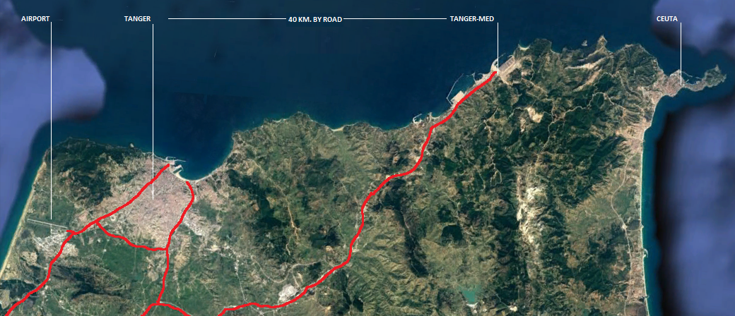
Tangier Med-port is a clear example of the territorial transformation. This is a complex of two big terminals 40 km from the city of Tangier between it and the Gibraltar straight. In a clear competitiveness with Algeciras port, these terminals were built since 2009 with capacities of 8.2 million TEU in their 300 Ha for this function. It is well known the issue between MAERSK and Algeciras Port in 2010, due to the competition between this port and Tangier Med [1].
The formal relations between this complex and the city of Tangier are not visible and the urbanization levels are very weak, based on the pre-existence of the village of Ksar-es-Seghir. Both evolution processes seem to be independent (Fig. 3).
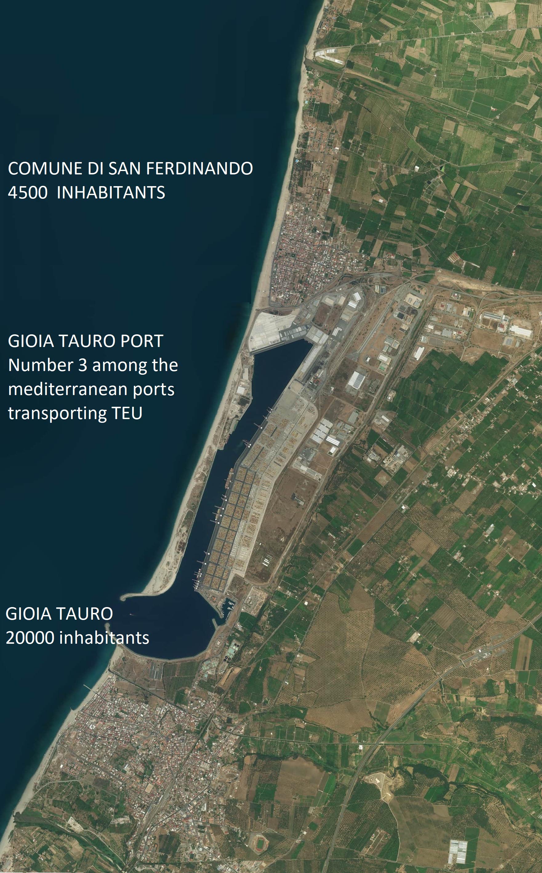
Gioia Tauro can be considered a failure as a regenerator of the region, but a successful experience form a business point of view for the transshipments. The lack of an adequate intermodal system linking with the main European corridors for transportation avoided a major regional impact. This case study is a clear sample where port and the city run parallel paths and the formal relations are clearly minimized (Fig. 4).
Marsaxlokk could be considered as an intermediate group, where an initial coexistence between the new port and the next village provoked in a second phase the urban expansion of the village with an important loss of urban identity. This village suffered an important change, from a fishermen village to a small urban shape as services provider.
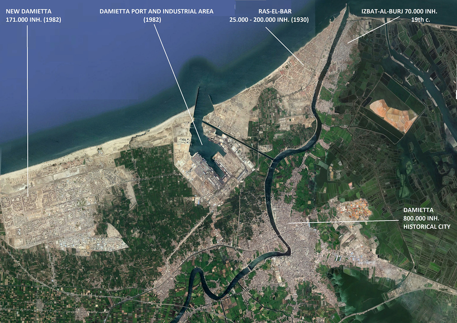
Finally, both Egyptian samples (New East Port Said – and New Damietta) develop a parallel activity with the respective neighbor cities In the case of Damietta; the new city is named New Damietta. It is a recent foundation city, since 1980. Initially designed for a target of 500.000 inhabitants, its current population of 171.000 enjoys a high level of services, including two Universities, as the antithesis of the capital of the Governorate, Damietta. Damietta port and New Damietta borders are separated by 2.7 km of agricultural lands. This port was built in parallel to the new City since 1982 (Fig. 5).
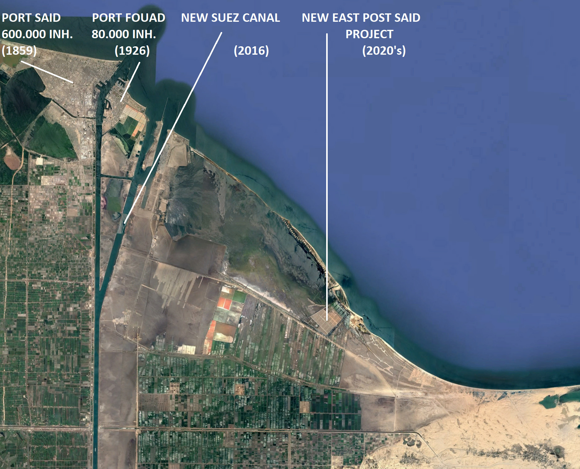
New East Port Said City is a part of an integrated project around the new port terminal located on the new Suez Canal, including an Industrial zone, the own port and a new city with a final target of one million of inhabitants. New East Port Said is located on the northeastern entrance of the Eastern Suez Canal, which is a unique position for the convergence of three continents, the movement of world trade between East and West, and attraction for ships transiting the Suez Canal.
The integrative project is previewing the reinforcement of the regional infrastructures, as the complement for this important territorial transformation of the northern mouth of the Canal. Roads leading to East Port Said area are Arish – Qantara Road, Port Fouad Ferry, and Qantara – East Port Said – Road will implement the project (Fig. 6).
These processes run in parallel to a progressive littoralization of all the Mediterranean Basin. This process was almost completed in the northern regions; meanwhile southern regions know different levels of anthropization. Other phenomena, like gentrification and land privatization were brought up, as two factors are contributing for this littoralization.
Several economic sectors are involved in all the several processes. Their respective combinations have formalized a general territorial competitiveness with different perspectives, depending of the respective dominant sectors.
Conclusions
The different historic steps of the Mediterranean Culture presented always the existence of two speeds for their respective implementations. Both banks of Mare Nostrum were usually reflecting correlative processes, where one part was subordinated to the other one in a continuous alternation.
Humanization process of Mediterranean Basin is not finished yet. The spread northern territories are serving as references for the progressive littoralization of the south and eastern banks, which could provoke a negative effect.
The binomial Port-City seems to be created nowadays in the opposite way was previously developed. New ports could provoke in most of cases the appearance of new cities. It is an excellent opportunity to apply territorial and urban principles of resilience and smart.
Involvement of the citizenship in these processes is one of the problems to be resolved, since citizens cannot be considered as recipients of its interventions but as partners deciding the type of city they want to live in when designing, implementing, and evaluating related projects. This ideal scenario is far from its achievement in this south bank, according to the development of the respective processes.
Notes
[1] In 2010, the multinational and leader in maritime traffic Maersk Line threatened to move around half a million containers per year from the main Spanish container port, Algeciras, to Tanger-Med (Morocco) due to the most advantageous conditions. Specifically, the company referred to a reduction of 20% in the final cost of a container if they opted for the African port. This meant a loss of around 35 million euros per year for the Spanish port. Therefore, the port of Algeciras could begin to lose its supremacy in container traffic in the Mediterranean.
[2] New Damietta was designed by NUCA as one of the new settlements proposed to decongest such areas of Nile Delta, in a position very close the port of Damietta, in 1980. This proximity favored the relation between the 15000 employees related to the port and their respective residences.
References
Cabrera M, Suarez A.,Trujillo L., (2014) Análisis del sector portuario español: en la búsqueda de factores que limitan la competencia in Cuadernos económicos de ICE 88, 47-76.
Pagés Madrigal, J., (2013) Medi Terraneum-البحر الأبيض المتوسط-al-Baḥr al-Mutawāsiṭ
In Portuplus Review, nr 25, 2013.
Pagés Madrigal, J.(2018), Some Notes about Architecture, Urbanism and Economy in International Journal of Contemporary Urban Affairs (2018) 2(2), 1-11.
Salem, I. and El-Sakty, S. (2014) Port selection criteria and its impact on port competitiveness in International Journal of Humanities and Social Sciences (IJHSS)Vol. 3, Issue 6, Nov 2014, 29-36.
Head Image:
Phoenician commercial routes. (© Bourrichon, 2009. Retouched image with translated texts) (https://commons.wikimedia.org/w/index.php?curid=8925644)Las relaciones puerto-ciudad. Una mirada desde el Mediterráneo Oriental
Las primeras navegaciones en el Mediterráneo parecen asociarse con el nacimiento del proceso de humanización de la Cuenca mediterránea, donde puertos y colonias estaban fuertemente relacionados dando el apoyo a este proceso.
Economia y competitivdad estuvieron en los origenes de la litoralización, ya que la economía no se puede entender a lo largo de la Historia sin la existencia de un espíritu competitivo. La visión contemporánea de este fenómeno incluye, a su vez, otros conceptos paralelos, como branding marketing territoriales, pero mantiene la esencia desde sus orígenes. Las disputas entre genoveses y venecianos solo se pueden entender desde una perspectiva económica. Finalmente, tanto los controles territoriales como las formas urbanas se relacionaban con estos hechos (Fig. 1-2).
Expansión genovesa a lo largo del Mar Mediterráneo.(https://upload.wikimedia.org/wikipedia/commons/7/73/Repubblica_di_Genova.png)
Expansión veneciana a lo largo del mar Mediterráneo. (© CC BY-SA 3.0)
Actualmente las ciudades necesitan posicionarse de un modo competitivo en el seno de la escala global. Estos hechos implican una doble perspectiva del problema. Por un lado muchas ciudades globales han experimentado el desarrollo de cambios sin precedentes en sus estructuras económicas, sociales y espaciales. Por otro lado estos procesos se vieron acompañados siempre de una creciente presencia del concepto branding en sus expasiones urbanas y territoriales consiguientes.
La imagen y reputación de las ciudades, así como sus percepciones externas, son conceptos fuertemente ligados a la evaluación de sus marcas. Port-cities, y especialmente los waterfronts urbanos, no son ajenos a estos fenómenos.
La urbanización de las costas mediterráneas se cuajó con fuertes relaciones entre los ouertos y nuevas colonias fudadas por los primeros navegantes. Los puertos más importantes estuvieron fuertemente relacionados con sus respectivas ciudades durante la Edad Media. A partir de ahí puertos y ciudades desarrollaron relaciones en cierto modo ambiguas en las que la fuerte relación inicial se fue diluyendo lenta y progresivamente. La institución de las autoridades portuarias durante los siglos 19 y 20 consumó esta separación. En cualquier caso, la relación entre puertos y ciudades se podrá siempre observar desde dos persectivas diferentes:
- desde el análisis y evaluación del desarrollo de las diversas actividades portuarias – en suma economias portuarias, o
- analizando los espacios portuarios desde perspectivas territorial o urbana. La interacción entre ambas perspectivas explicará de un modo global el conjunto del proceso.
El análisis previo de un cierto número de casos-estudio nos permitirá referir algunos aspectos comunes a ellos, con un trasfondo de competitividad, bien interna, entre el puerto y la ciudad; o externa entre otros casos estudio:
Desde una perspectiva urbana
- La existencia de una competitividad en la gestión de los espacios comunes o de relación, lo que se traduce en un conflicto de prácticas de gestión.
- La creciente demanda proveniente de las ciudades para conseguir la transformación de los frentes marítimos urbanos, procurando así sus propios mercados. Waterfronts son al final landmarks que contribuyen de este modo para la mejora de la marca urbana, como el mejor modo de poder competir con otras ciudades.
Desde una perspectiva portuaria
- El cambio radical del concepto del negocio portuario, lo que obliga a algunos puertos a modificar sus objetivos económicos. Los puertos se convirtieron hoy en día en proveedores de servicios con una clara diversificación de riesgos.
- La concentración de los recursos económicos en los principales puertos, en relación directa con las inversiones importantes destinadas a consolidar las respectivas actualizaciones, para garantizar el nivel de competitividad. Este hecho implicó un proceso de selección creando dos velocidades para el desarrollo de áreas portuarias.
- La activación de los nuevos nichos de mercado con la importante irrupción de los cruceros, afectando no solo a los infrastructuras portuarias sino también a las respectivas ciudades.
Desde la doble perspectiva
- La preservación de industrias obsoletas de ambos lados(bien ciudad, bien puerto) que necesitan transformarse para mantener un nivel adecuado de competitividad.
- La transformación de las propiedades de suelo portuario en una oportunidad más para el negocio, ya que su ubicación y condiciones preferenciales atrajeron a tantos inversionistas urbanos.
De hecho, a menor importancia económica de los puertos respectivos, menor separación entre puertos y forma urbana.
La doble velocidad del proceso como desafío
Las ciudades portuarias del Mediterráneo oriental han conocido diversas fases en su evolución histórica. Esta cuenca ha sido el escenario de todas las encrucijadas culturales imaginables, junto con los flujos económicos producidos por ambos sentidos, ya sea del Este o del Oeste.
Hoy somos testigos de la existencia de dos velocidades en la forma de gestionar las estructuras portuarias. La contenerización de las cargas implicó una última transformación de los puertos, a través de la automatización de los procesos, su hiperactividad y la alta competitividad entre ellos. El alto nivel de especialización de un grupo de puertos implicaba un progresivo distanciamiento de las estructuras convencionales, tanto en términos de volumen de negocio como en la estructuración de la forma portuaria.
En paralelo, otros puertos conocían la disminución y cancelación de este sector de negocio, debido a la falta de respuestas adecuadas a las demandas de los clientes. Estaban condenados a permanecer fuera de los grandes circuitos de transportes, y actuando solo para cargos locales con una importante reducción de sus respectivos territorios interiores. Una nueva tipología de puertos irrumpió en el escenario. Tal es el caso de la activación de puertos especializados sin una relación inicial con ninguna ciudad en el contexto.
Se pueden considerar como la forma de sentir una nueva humanización de la expansión de la costa donde se ha abandonado el concepto binómico ciudad-puerto convencional. En la última década, se han creado al menos cinco nuevos puertos en el Mediterráneo: Tanger Med, Gioia Tauro, Marsaxlokk, New East Port Said y Damietta. Éstos nuevos puertos que se construyeron sin ninguna relación aparente con los procesos de urbanización o una relación débil entre el puerto y la forma urbana. Podemos diferenciar varias opciones dentro de este grupo de puertos.
Un primer grupo podría definir una relación casi inexistente entre el nuevo puerto y los asentamientos urbanos próximos a ellos. Tanger Med y Gioia Tauro se pueden considerar dentro de este primer grupo.
Tanger Med-port es un claro ejemplo de la transformación territorial. Éste es un complejo de dos grandes terminales a 40 km de la ciudad de Tánger, entre ésta y el estrecho de Gibraltar. En una clara competencia con el puerto de Algeciras, estas terminales se construyeron desde 2009 con capacidad de 8.2 millones de TEU en sus 300 Ha para esta función. Es bien conocido el problema entre MAERSK y el puerto de Algeciras en 2010, debido a la competencia entre este puerto y Tanger Med [1].
Las relaciones formales entre este complejo y la ciudad de Tánger no son visibles y los niveles de urbanización son muy débiles, basados en la preexistencia del vecino pueblo de Ksar-es-Seghir. Ambos procesos de evolución parecen ser independientes (Fig. 3).
Estructura territorial de Tánger-Med. (Fuente: sobre la base de Google Earth, por el autor)
Gioia Tauro puede considerarse un fracaso como regenerador de la región, pero una experiencia exitosa desde un punto de vista empresarial para los transbordos. La falta de un sistema intermodal adecuado que conecte con los principales corredores europeos para el transporte evitó un gran impacto regional. Este caso de estudio es una muestra clara en la que el puerto y la ciudad recorren caminos paralelos y las relaciones formales se minimizan claramente (Fig. 4).
Estructura territorial de Gioia Tauro. (Fuente: sobre la base de Google Earth, por el autor)
Marsaxlokk podría considerarse como un grupo intermedio, donde una coexistencia inicial entre el nuevo puerto y el próximo pueblo provocó en una segunda fase la expansión urbana del pueblo con una importante pérdida de identidad urbana. Este pueblo sufrió un cambio importante, de un pueblo de pescadores a una pequeña forma urbana como proveedor de servicios.
Finalmente, ambos casos egipcios (New East Port Said y Damietta) desarrollan una actividad paralela con las respectivas ciudades vecinas. En el caso de Damietta, la relación se establece a través de Nueva Damietta [2]. Es una ciudad de fundación reciente, en 1982. Inicialmente diseñada con el objetivo de 500.000 habitantes, su población actual de 171.000 cuenta con un alto nivel de servicios, incluidas dos universidades, como la antítesis de la capital de la Gobernación, Damietta. El puerto de Damietta y New Damietta están separados por 2,7 km de tierras agrícolas. Este puerto fue construido en paralelo a la nueva ciudad desde 1982 (Fig. 5).
Estructura territorial de New Damietta. (Fuente: sobre la base de Google Earth, por el autor)
New East Port Said City es parte de un proyecto integrado alrededor de la nueva terminal portuaria ubicada en el nuevo canal de Suez, que incluye una zona industrial, el propio puerto y una nueva ciudad con un objetivo final de un millón de habitantes. New East Port Said se encuentra en la entrada noreste del Canal Oriental de Suez, que es una posición única para la convergencia de tres continentes, el movimiento del comercio mundial entre Oriente y Occidente, y la atracción para los buques que transitan por el Canal de Suez.
El proyecto integrador está anticipando el refuerzo de las infraestructuras regionales, como complemento de esta importante transformación territorial de la desembocadura norte del Canal. Las carreteras que conducen al área de East Port Said son Arish – Qantara Road, Port Fouad Ferry y Qantara – East Port Said – Road implementará el proyecto (Fig. 6).
Estructura territorial de Great Port Said. (Fuente: sobre la base de Google Earth, por el autor)
Estos procesos se ejecutan en paralelo a una litoralización progresiva de toda la cuenca mediterránea. Este proceso casi se completó en las regiones del norte; mientras tanto, las regiones sureñas conocen diferentes niveles de antropización. Otros fenómenos, como el gentrificación y la privatización de la tierra, se plantearon, ya que ambos factores contribuyen a esta litoralización.
Varios sectores económicos están involucrados en todos los procesos. Sus respectivas combinaciones han formalizado una competitividad territorial general con diferentes perspectivas, dependiendo de los respectivos sectores dominantes.
Conclusiones
Las diferentes fases históricas de la Cultura Mediterránea presentaron siempre la existencia de dos velocidades para sus respectivas implementaciones. Ambas orillas del Mare Nostrum generalmente reflejaban procesos correlativos, donde una parte estaba subordinada a la otra en una alternancia continua.
El proceso de humanización de la cuenca mediterránea aún no está terminado. Los territorios del norte extendidos sirven como referencias para la litoralización progresiva de los bancos del sur y del este, lo que podría provocar un efecto negativo.
El binomio Port-City parece haber sido creado hoy en día en la forma opuesta desarrollada anteriormente. Los nuevos puertos podrían provocar en la mayoría de los casos la aparición de nuevas ciudades. Es una excelente oportunidad para aplicar los principios territoriales y urbanos de resiliencia e inteligencia.
La participación de la ciudadanía en estos procesos es uno de los problemas a resolver, ya que los ciudadanos no pueden ser considerados como destinatarios de sus intervenciones sino como socios que deciden el tipo de ciudad en la que desean vivir cuando diseñan, implementan y evalúan proyectos relacionados. Este escenario ideal está lejos de su logro en este flanco sur, de acuerdo con el desarrollo actual de los respectivos procesos.
Notas
[1] En 2010 la multinacional del tráfico marítimo Maersk Line amenazó con el desplazamiento de alrededor de medio millón de contendores desde el principal puerto español de contenedores -Algeciras- hacia Tanger-Med (Marruecos), dadas sus condiciones más ventajosas. Dicha compañía refirió específicamente una reducción ofrecida por el puerto africano del 20% sobre el costo final de cada contenedor, lo que supondría una pérdida anual para el puerto español de 35 millones de euros. Esta circunstancia supondría al mismo tiempo la perdida de la supremacía de este puerto en el tráfico mediterráneo de contenedores.
[2] La entidad estatal NUCA (New Urban Communities Authority) diseñó la ciudad de New Damietta para formar parte de los asentamientos propuestos para descongestionar el delta del Nilo, dada su posición vecina al puerto de Damietta, en 1982. Esta proximidad favoreció el hecho de proporcionar empleo a 15.000 ciudadanos, en una clara relación entre Puerto y ciudad.
Referencias
Cabrera M, Suarez A.,Trujillo L., (2014) Análisis del sector portuario español: en la búsqueda de factores que limitan la competencia in Cuadernos económicos de ICE 88, 47-76.
Pagés Madrigal, J., (2013) Medi Terraneum-البحر الأبيض المتوسط-al-Baḥr al-Mutawāsiṭ
In Portuplus Review, nr 25, 2013.
Pagés Madrigal, J.(2018), Some Notes about Architecture, Urbanism and Economy in International Journal of Contemporary Urban Affairs (2018) 2(2), 1-11.
Salem, I. and El-Sakty, S. (2014) Port selection criteria and its impact on port competitiveness in International Journal of Humanities and Social Sciences (IJHSS)Vol. 3, Issue 6, Nov 2014, 29-36.
Head Image: Las rutas comerciales de los fenicios. (© Bourrichon, 2009)