«They tell me that some are not interested in maps; I struggle to believe it… Even if the map is not the whole plot, as in Treasure Island, it will always prove a mine of suggestions».
Robert Louis Stevenson
In the wide universe of cartography, island maps possess a very particular charm. Two worlds – that of the maps and that of the islands – which translate into rich and colorful forms. Sometimes they appear in their absolute isolation, surrounded by a blue belt that separates them from the rest of the world, sometimes instead they are arranged in an archipelago, scattered like seeds thrown into the water, sometimes they are just suggested, a rock or a cliff identified by calligraphic names in the waves.
The Stevenson Collective, founded by five artists, collectors and researchers, aimed to explore and celebrate its beauty, incongruities, fantasies as well as their detailed data and description. Mappa insulae is the result of this collaboration and of the collection of the cartographic treasures found, recovered, buried and patiently collected. A volume composed of sixty maps and illustrations of islands, accompanied by comments and literary quotations on the theme of insularity. From map to map, from island to island, from thoughts to poems, one is led to an erudite and unusual crossing. By placing a map alongside a literary text – Jules Verne, Thomas More, Stevenson, Melville, Marcel Broodthaers, Borges, JM Coetzee, Arthur Rimbaud, Pedrag Matvejevitch, Hernan Cortes, Pierre de Ronsard, Leon Werth and many others … -, authors highlight the specificity of island maps which, reduced to the essentials, can be defined as “a circle on a plane”. The sea represents the limit, the border, but also the white page – or rather, the ‘blue’ page – on which to write the history of the islands. Islands that sometimes disappear from maps because they are forgotten or because they are too far from the continents, too isolated and therefore insignificant, invisible.
This work was carried out in the framework of a literary residence at the Fondation Camargo, in Cassis, during the autumn of 2017 and the spring of 2018. A shared experience that also led to an exhibition “Le temps de l’ile” at the Mucem – Musée des civilisations de l’Europe et de la Méditerranée (www.mucem.org) in Marseilles in progress until 11 November 2019. The exhibition starts from the assumption that “we are all inhabited by the islands. Everyone keeps in mind memories, projects or island dreams. The novels, the films, the atlases give them a power of evocation without equal, even when they are imaginary”.
The Mediterranean, for example, has over ten thousand islands. Its history is marked by these places which, depending on the case, are centers or margins, paradises or spaces of detention. Some, in this and other seas, represent crucial challenges in the contemporary world such as Cyprus and Lampedusa, the Comoros, New Caledonia and the Caymans, to name just a few.
The exhibition therefore considers insularity as an experience and a tool to understand the world, exploring the effects of the islands on the imaginary, the knowledge, the geopolitical reality, the utopias of yesterday and tomorrow. Whether we are inhabitants of the islands or not, we are all islanders.
Maps, explorers’ documents, naturalized animals, but also Roman mosaics, paintings, sculptures, photographs, videos, installations: almost 200 pieces from French, European and Mediterranean institutions as well as works of contemporary art, created specifically for this project.
As an extension of the exhibition, Mucem and the National Monuments Center invite the public to take the sea to reach the island of If, near the old port of Marseille, to discover a series of works by the artist David Renaud in the context of exhibition “The invention of the distant“.
Head image: “Le temps de l’ile”, exhibition at the MUCEM (www.mucem.org) in Marseille until 11 November 2019.
Mappa Insulae
«Mi dicono che alcuni non si interessano alla mappe; fatico a crederlo… Anche se la mappa non è tutta la trama, come in Treasure Island, si dimostrerà sempre una miniera di suggestioni».
Robert Louis Stevenson
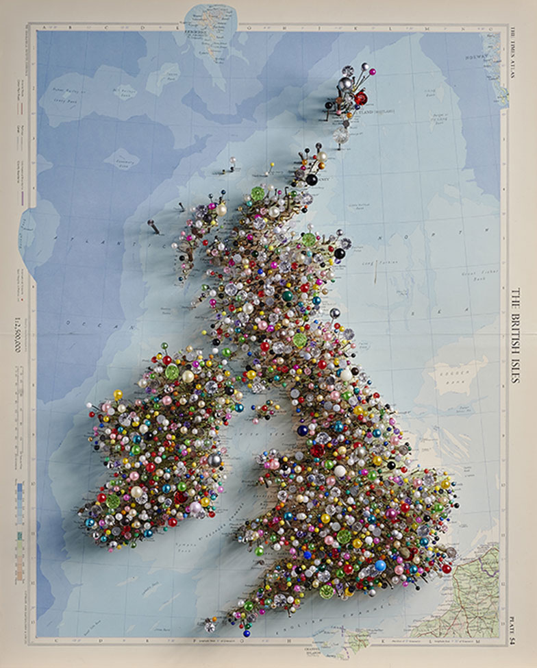
Chris Kenny Fetish Map of the British Isles. (© Chris Kenny, photo Gabriel Kenny Ryder)
Nell’universo infinito della cartografia, le mappe delle isole possiedono un fascino molto particolare. Due universi – quello delle mappe e quello delle isole – che si traducono in forme ricche e colorate. A volte esse appaiono nel loro assoluto isolamento, circondate da una cintura blu che le separa dal resto del mondo, a volte invece sono disposte in arcipelago, sparse come tanti semi lanciati nell’acqua, a volte ancora sono solo suggerite, una roccia o una scogliera identificata da nomi calligrafici tra le onde.
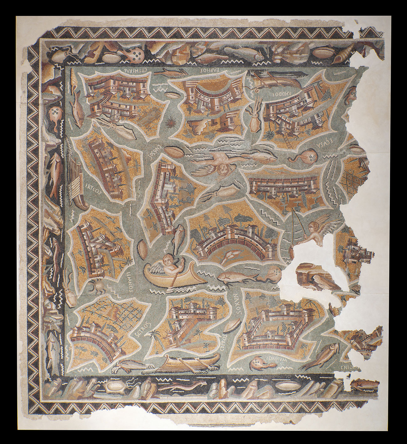
Mosaïque aux îles, III-IVe siècle apr. J.-C., Haïdra, Tunisie. 492 × 536 × 7 cm. Institut national du patrimoine, Tunisie. (© Institut National du Patrimoine, Tunisie, photo Rémi Bénali – MDAA / CD13)
Il Collettivo Stevenson, fondato da cinque tra artisti, collezionisti e ricercatori, ha inteso esplorarne e celebrarne le bellezze, le incongruità, le fantasie oltre che la loro precisione e il loro dettaglio. Da questo incontro e dalla raccolta dei tesori cartografici, trovati, recuperati, sepolti e collezionati pazientemente, nasce Mappa insulae. Un volume composto da sessanta mappe e illustrazioni di isole, accompagnate da commenti e citazioni letterarie sul tema della insularità. Di mappa in mappa, di isola in isola, di pensieri in poesie, si viene condotti in una traversata erudita e insolita. Affiancando una mappa ad un testo letterario – da Jules Verne a Thomas More, da Stevenson a Melville, da Marcel Broodthaers a Borges, J. M. Coetzee, Arthur Rimbaud, Pedrag Matvejevitch, Hernan Cortès, Pierre de Ronsard, Leon Werth e molti altri… – , gli autori evidenziano la specificità delle mappe delle isole che, ridotte all’essenziale, possono essere definite come “un cerchio su un piano”. Il mare rappresenta il limite, il confine, ma anche la pagina bianca – o meglio, la pagina blu – su cui scrivere la storia delle isole. Isole che a volte scompaiono dalle mappe perché dimenticate o perché troppo lontane dai continenti, troppo isolate e quindi in qualche modo insignificanti, invisibili.
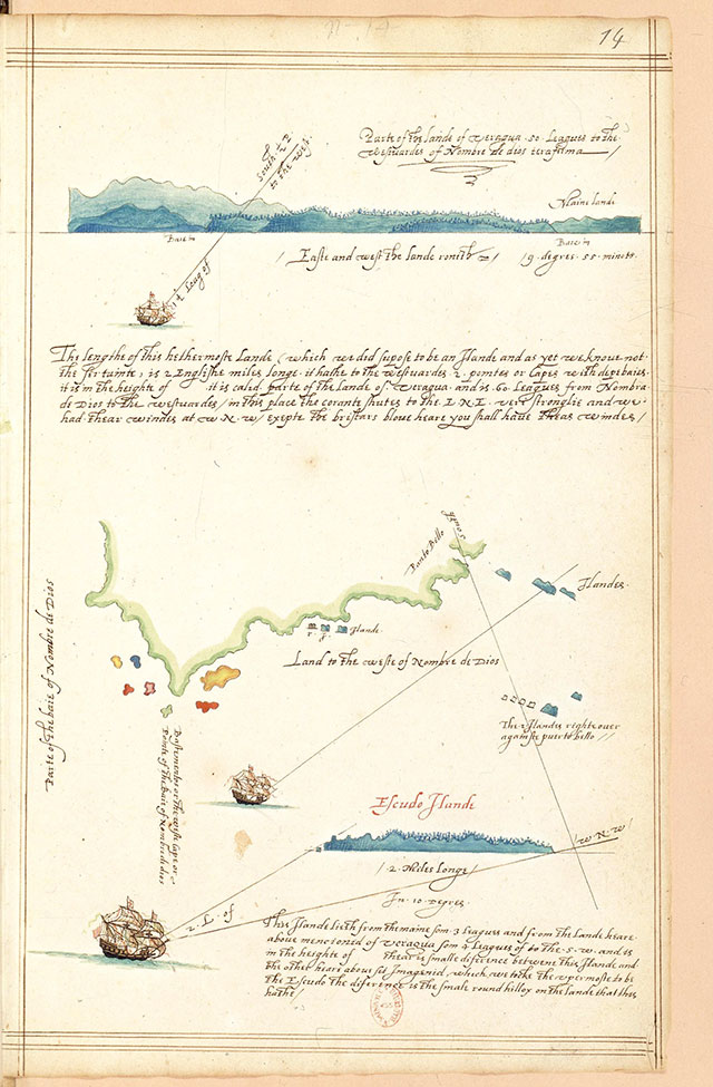
Journal illustré du voyage de Francis Drake aux Indes occidentales, folio 14, 1595-1596. Manuscrit aquarellé sur papier, 32,5 × 20,5 cm. Bibliothèque nationale de France, Paris. (© BnF)
Il lavoro è stato realizzato nel quadro di una residenza letteraria presso la Fondation Camargo, a Cassis, durante l’autunno 2017 e la primavera del 2018. Un’esperienza condivisa che ha portato anche ad una mostra “Le temps de l’ile” presso il MUCEM (www.mucem.org) di Marsiglia in corso sino all’11 novembre 2019. La mostra parte dal presupposto che “siamo tutti abitati dalle isole. Ognuno tiene a mente ricordi, progetti o sogni insulari. I romanzi, i film, gli atlanti danno loro un potere di evocazione senza eguali, anche quando sono immaginari”.
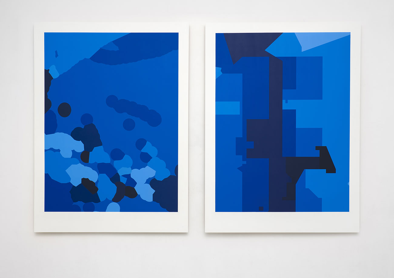
David Renaud, Pacifique II (ZEE) et Pacifique I (fuseaux horaires), 2019. Acrylique sur bois verni, 203 × 150 cm chacun. Collection de l’artiste. (© David Renaud, photo Florian Kleinefenn)
Il Mediterraneo ad esempio ha più di diecimila isole. La sua storia è segnata da questi luoghi che, a seconda dei casi, sono centri o margini, paradisi o spazi di detenzione. Alcune, in questo e in altri mari, sono sfide cruciali del mondo contemporaneo come Cipro e Lampedusa, le Comore, la Nuova Caledonia e le Cayman, per citarne soltanto alcune.
Davide Bertocchi, Tropicalnocturnal (EP), éd. 1 / 3, 2019. Jet d’encre pigmentaire sur papier archival, 103 × 146,7 cm. Collection particulière. (© Davide Bertocchi)
La mostra quindi considera l’insularità come un’esperienza e uno strumento per comprendere il mondo, esplorando gli effetti delle isole sull’immaginario, la conoscenza, la realtà geopolitica, le utopie di ieri e di domani. Abitanti o meno delle isole, siamo tutti isolani.
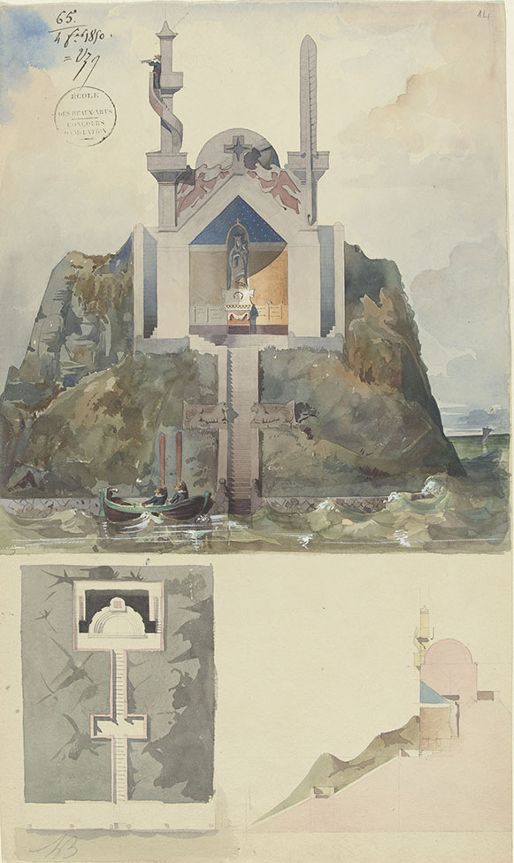
Louis Boitte, Chapelle sur un rocher, projet pour un concours d’émulation, 1850. Crayon, aquarelle et rehauts de gouache blanche, 45,7 × 27,1 cm. Paris, musée d’Orsay, don de Mlle Alice Boitte. (© RMN-Grand Palais, Musée d’Orsay / Hervé Lewandowski)
Mappe, documenti degli esploratori, animali naturalizzati, ma anche mosaici romani, dipinti, sculture, fotografie, video, installazioni: quasi 200 pezzi provenienti da istituzioni francesi, europee e mediterranee così come opere d’arte contemporanea, realizzate appositamente per questo progetto.
Come estensione della mostra, il MUCEUM e il National Monuments Centre invitano il pubblico a prendere il mare per raggiungere l’isola di If, vicino al vecchio porto di Marsiglia, alla scoperta di una serie di opere dell’artista David Renaud nell’ambito della mostra “L’invenzione del lontano“.
Head image: “Le temps de l’ile”, mostra presso il MUCEM (www.mucem.org) di Marsiglia fino all’11 novembre 2019.