╔
The Atlas, that is part of the series on the Urbanization of the Sea and the kick-off of a sub-series on Mapping Port Cities, was created within the LDE PortCityFutures research group and the Faculty of Architecture TU Delft. Conceived as a work of reference, the book makes the case for a sea-based approach to the understanding and design of European coasts.
Europe’s coastline is dotted with a multitude of port cities, all designed to facilitate maritime transport. Over millennia, public and private leaders have built ports, urban spaces and infrastructures in diverse territories to serve hinterlands, including landlocked capital cities and metropolitan areas. As nodes at the interface of water and land, port city territories embody knowledge on maritime flows and water conditions. In an era of climate change, they can be paradigms and stewards of sustainable development.
Taking a comprehensive, mapping based approach, Port City Atlas is an analytical study on the complexity of port cities in Europe, visualising 100 territories located on four seas and connected through shared waters. It provides a foundation for comparative analysis beyond case study approaches that are often locked into national contexts, select languages or disciplinary approaches.
L’Atlante, parte della serie “Urbanization of the Sea” e avvio di una sottoserie “Mapping Port Cities”, è stato realizzato all’interno del gruppo di ricerca LDE PortCityFutures e della Facoltà di Architettura di TU Delft. Concepita come un’opera di riferimento nel settore, la pubblicazione sostiene un approccio basato sul mare per la comprensione e la progettazione delle coste europee.
Una moltitudine di città portuali punteggia le coste dell’Europa, al fine di facilitare il trasporto marittimo. Nel corso dei millenni, leader pubblici e soggetti privati hanno costruito porti, spazi urbani e infrastrutture in diversi territori per servire l’entroterra, comprese le capitali e le aree metropolitane prive di sbocco sul mare. In quanto nodi sull’interfaccia tra acqua e terra, i territori delle città portuali incarnano la conoscenza dei flussi marittimi e delle condizioni dei fronti d’acqua. In un’era di cambiamento climatico, possono essere paradigmi e custodi dello sviluppo sostenibile.
Port City Atlas, adottando un approccio globale basato sulla mappatura, si attesta come uno studio analitico sulla complessità delle città portuali in Europa che visualizza 100 territori affacciati su quattro mari e collegati attraverso acque condivise. Fornisce una base per l’analisi comparativa al di là degli approcci di studio di casi spesso bloccati in contesti nazionali, lingue selezionate o approcci disciplinari.
The word to the Authors
La parola agli Autori
Oriana GIOVINAZZI – How can mapping help to better understand the territories of European port cities?
Carola HEIN, Yvonne VAN MIL, Lucija AZMAN-MOMIRSKI – Understanding the unique spaces of port city territories, where global flows meet local geographies, topographies, histories and practices, requires a unified approach to visualisation, specifically the mapping of a large number of territories in a unified way. Such an approach can help us to better understand the spatial interconnection between the port, city and territory. It also helps us to explore the relationship between multiple port city territories as part of international trade networks, facilitating the identification of ‘gaps’ (Hein & Van Mil, 2020) where spatial, institutional or cultural opportunities and challenges exist, and where planning can be beneficial. The Port City Atlas presents a new conceptual and methodological approach to international comparative research, as a bridge between different disciplines and fields, and as a catalyst for new scientific and professional explorations of the influence of ports on cities and territories.
Oriana GIOVINAZZI – In che modo la mappatura può contribuire ad una migliore comprensione dei territori delle città portuali europee?
Carola HEIN, Yvonne VAN MIL, Lucija AZMAN-MOMIRSKI – Comprendere gli spazi unici dei territori delle città portuali, dove i flussi globali incontrano geografie, topografie, storie e pratiche locali, richiede un approccio unificato alla visualizzazione, in particolare la mappatura di un gran numero di territori in modo unitario. Tale approccio può aiutarci a comprendere meglio l’interconnessione spaziale tra porto, città e territorio. Così come ad esplorare la relazione tra più territori di città portuali come parti delle reti commerciali internazionali, facilitando così l’identificazione di “gap” (Hein & Van Mil, 2020) dove esistono opportunità e sfide spaziali, istituzionali o culturali, e dove la pianificazione può rivelarsi vantaggiosa. Port City Atlas propone un nuovo approccio concettuale e metodologico alla ricerca comparativa internazionale, come ponte tra diverse discipline e campi, e come catalizzatore per nuove esplorazioni scientifiche e professionali dell’influenza dei porti su città e territori.
Can the maritime perspective on port cities be integrated with more traditional approaches to the territory?
Public and private responses to contemporary crises such as climate change, rising sea levels and migration depend on coordinated approaches along Europe’s coasts. Yet Europe’s maritime borders are rarely recognised as part of European policy-making and identity-making. The internal focus on nation states, national borders and European unification has distracted policymakers and stakeholders from a maritime perspective of the continent. But looking from sea to land, we can see seaports and their unique role in shaping Europe’s future, as continent surrounded by water on three sides, with major seaports and metropolises along its coastlines. Moreover, we can see the port and its adjacent port city, the maritime foreland and the terrestrial hinterland as a distinct type of space: the port city territories.
La prospettiva marittima sulle città portuali può essere integrata con approcci più tradizionali al territorio?
Le risposte pubbliche e private alle crisi contemporanee come il cambiamento climatico, l’innalzamento del livello del mare e la migrazione dipendono da approcci coordinati lungo le coste europee. Eppure i confini marittimi dell’Europa sono raramente riconosciuti come parte del processo decisionale e dell’identità europea. L’attenzione interna sugli stati nazione, i confini nazionali e l’unificazione europea ha distratto i politici e le parti interessate da una prospettiva marittima del continente. Ma guardando dal mare alla terra, possiamo vedere i porti marittimi e il loro ruolo unico nel plasmare il futuro dell’Europa, in quanto continente circondato dall’acqua su tre lati, con importanti porti marittimi e metropoli lungo le sue coste. Inoltre, possiamo vedere il porto e la sua adiacente città portuale, il promontorio marittimo e l’entroterra terrestre come un tipo distinto di spazio: i territori della città portuale.
What are the advantages and opportunities in facing contemporary challenges from this perspective?
The Port City Atlas shines a light on the port city territory as a key actor, a significant location and a potential steward of the water future, using a sea-based approach that sees water as a prominent connector of ports, cities and surrounding territories, for human life as well as for shipping – overcoming traditional land-based approaches that depend on national borders. This perspective helps to bridge national differences and opens up a critical new opportunity to address today’s challenges at the land-sea interface in a coordinated way: climate crises, energy transitions, migration and multiple water-related emergencies. The maritime perspective also shows us that stakeholders in these territories are diverse and multiple, that governance at the scale of the territory is lacking, that methodologies to fully understand these territories are lacking, and that the important impact of ports on territorial development is not fully understood.
Quali sono i vantaggi e le opportunità nell’affrontare le sfide contemporanee da questa prospettiva?
Port City Atlas è focalizzato su questi territori in quanto attori chiave, luoghi significativi e potenziali amministratori del futuro dell’acqua, utilizzando un approccio basato sul mare che vede l’acqua come importante prominente di porti, città e territori circostanti, per la vita umana così come per la navigazione, superando i tradizionali approcci terrestri che dipendono dai confini nazionali. Questa prospettiva contribuisce a colmare le differenze nazionali e ad aprire una nuova opportunità critica per affrontare le sfide odierne sull’interfaccia terra-mare in modo coordinato: crisi climatiche, transizioni energetiche, migrazioni e molteplici emergenze legate all’acqua. La prospettiva marittima evidenzia inoltre come le parti interessate in questi territori siano diverse e molteplici, come si avverta la mancanza di una governance alla scala del territorio, così come di metodologie per comprendere appieno questi territori, e come il rilevante impatto dei porti sullo sviluppo territoriale non risulti pienamente compreso.
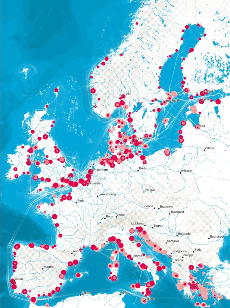
European ports ranked by type (passenger and cargo) and volume of throughput (extract from © Port City Atlas).
Maps are, and have been over time, a key tool for understanding and studying port cities. What role can and will they have in relation to the proposed methodological approach?
In our new methodological approach to understanding and designing coastal areas, the first step is to conceptualise the contemporary port city territory – its form, governance and culture – as unique, and to develop methods for visualising the multiple flows, institutions and practices that occur in these territories. In the Port City Atlas we argue that the visualisation of quantitative and qualitative data in maps and infographics can provide a basis for comparative analysis beyond case study approaches, which are often locked into national contexts, selected languages or disciplinary approaches (Hein & Van Mil, 2019). We suggest that a comprehensive (geo)spatial mapping approach allows for the exploration of a single port city territory as part of a larger system of maritime and transport connections, by means of standardised comparisons across territories. In addition, mapping can serve as a tool for identifying transitional territories – what we call a ‘gap finder’ – that often cross institutional boundaries without strong, mutually supportive governance frameworks, legal systems and planning policies.
Le mappe sono, e sono state nel tempo, uno strumento fondamentale per conoscere e studiare le città portuali. Che ruolo possono e potranno avere in relazione all’approccio metodologico proposto?
Nel nostro nuovo approccio metodologico alla comprensione e alla progettazione delle aree costiere, il primo step consiste nel concettualizzare il territorio della città portuale contemporanea – la sua forma, governance e cultura – come unico, e sviluppare metodi per visualizzare i molteplici flussi, le istituzioni e le pratiche che interessano questi territori. In Port City Atlas sosteniamo che la visualizzazione di dati quantitativi e qualitativi in mappe e infografiche può fornire una base per l’analisi comparativa al di là degli approcci di studio di casi, che sono spesso bloccati in contesti nazionali, lingue selezionate o approcci disciplinari (Hein & Van Mil, 2019). Suggeriamo che un approccio globale alla mappatura (geo)spaziale consenta l’esplorazione di un singolo territorio di una città portuale come parte di un sistema più ampio di collegamenti marittimi e di trasporto, mediante confronti standardizzati tra territori. Inoltre, la mappatura può servire come strumento per identificare i territori di transizione – ciò che chiamiamo “gap finder” – che spesso attraversano i confini istituzionali senza strutture di governance, sistemi giuridici e politiche di pianificazione forti e di supporto reciproco.
The Atlas also refers to a multi-scale approach, defined in relation to different levels of territorial interest. Can you briefly describe how the different spatial and functional areas examined relate to each other?
In order to study European port city territories in the light of their global, national and local contexts, we used a multi-scale approach and defined three levels of spatial interest: Europe, the four maritime water of the European continent and the port city territory. The European scale means that all port cities are part of the same overarching political entity, with corresponding legislation, regulation and a common history. Maps at this scale show how the port city territories are connected by water and land, and how they relate to each other, to their geographical, topographical and political context, and to the European trading network (through data on global shipping routes and other sea-based networks, digital elevation models, population densities and inland transport links). At the same time, the nations are very different, and their borders have changed over time. By adding a second scale and exploring the port city territories within and between the four seas that surround Europe – the Baltic Sea, the North Sea, the North Atlantic Ocean and the Mediterranean Sea – we identified particular constellations and conditions, such as natural geographical conditions (through coastal morphology and bathymetry data), cultural and political settings and their position in maritime networks, which are different for each sea. The third – and most prominent – scale in the atlas is the port city territory, which captures the spatial relationship between the port, the adjacent city and the surrounding landscape, as well as their geographical location and urban patterns, transport networks and institutional boundaries.
L’Atlante fa riferimento anche ad un approccio multiscala, definito in relazione a diversi livelli di interesse territoriale. Potete descrivere brevemente come le diverse aree spaziali e funzionali prese in esame si relazionano tra loro?
Per studiare i territori delle città portuali europee alla luce dei loro contesti globali, nazionali e locali, abbiamo utilizzato un approccio multiscala e definito tre livelli di interesse spaziale: l’Europa, le quattro acque marittime del continente europeo e il territorio delle città portuali. La scala europea rappresenta come tutte le città portuali fanno parte della stessa entità politica globale, con legislazione, regolamentazione e storia comune. Le mappe a questa scala mostrano come i territori delle città portuali sono collegati da acqua e terra, e come si relazionano tra loro, con il loro contesto geografico, topografico e politico, e con la rete commerciale europea (attraverso i dati sulle rotte marittime globali e altre reti digitali, modelli digitali di elevazione, densità di popolazione e collegamenti di trasporto terrestre). Allo stesso tempo, le nazioni sono molto diverse e i loro confini sono cambiati nel tempo. Aggiungendo una seconda scala ed esplorando i territori delle città portuali all’interno e tra i quattro mari che circondano l’Europa – il Mar Baltico, il Mare del Nord, l’Oceano Atlantico settentrionale e il Mar Mediterraneo – abbiamo individuato particolari costellazioni e condizioni, come le condizioni geografiche naturali (attraverso i dati di morfologia e batimetria costiera), i contesti culturali e politici e la loro collocazione nei reticoli marittimi, diversi per ogni mare. La terza e più importante scala nell’atlante è il territorio della città portuale, che coglie la relazione spaziale tra il porto, la città adiacente e il paesaggio circostante, nonché la loro posizione geografica e i modelli urbani, le reti di trasporto e i confini istituzionali.
In the Port City Atlas, 100 European port city territories are mapped and presented in a comparative and uniform way. What emerges from the comparison and study of the water-land interface in relation to the approach used?
The maps show selected ports with adjacent cities and port city territories, integrating their maritime and land parts. Infographics further illustrate key geographic, port, port city and port territory data. This work provides the basis for re-conceptualising the European port city territories, both in academic research and in future development and planning, allowing the water-land interface to be identified, compared and studied. In selecting the top 100 seaport city territories, we considered ports as key signifiers in the movement of people and goods from sea to land and from land to sea. Based on maritime flows, we first identified the leading ports using Eurostat maritime statistics and then looked at each port’s neighbouring city or cities and port city territory. In order to identify the leading port city territories, we used port functions (cargo and passenger ports) to rank the top 25 ports for each of the four maritime waters. Taking into account the total gross weight of cargo and the total number of passengers, combined with the number of people living in the neighbouring territory using population figures from Eurostat NUTS3 regions, we selected the top 100 European ports. This group includes major port cities such as Rotterdam, Hamburg and Marseille, as well as smaller ones such as the Finnish oil port of Sköldvik or the transhipment hub of Puttgarden. We have also included ports that don’t meet these criteria, such as Bordeaux and Oslo. We have included them because they are important historical and cultural port cities that have adapted to the transit of goods and passengers over decades, sometimes centuries. Although they have recently lost some of their port function and cannot compete with modern industrial ports, their urban structure, infrastructure and architecture are still based on this (former) port function and they face similar future challenges as other port cities, such as the redevelopment of former industrial port areas.
In Port City Atlas, 100 territori di città portuali europee sono mappati e presentati in modo comparativo e uniforme. Cosa emerge dal confronto e dallo studio dell’interfaccia acqua-terra in relazione all’approccio utilizzato?
Le mappe mostrano porti selezionati con città adiacenti e territori di città portuali, integrando le loro parti marittime e terrestri. Le infografiche illustrano ulteriormente i principali dati geografici, portuali, città portuali e territorio portuale. Questo lavoro fornisce la base per riconcettualizzare i territori delle città portuali europee, sia nella ricerca accademica che nello sviluppo e nella pianificazione futuri, consentendo di identificare, confrontare e studiare l’interfaccia acqua-terra. Nella selezione dei primi 100 territori delle città portuali, abbiamo considerato i porti come significanti chiave nel movimento di persone e merci dal mare alla terraferma e dalla terraferma al mare. Sulla base dei flussi marittimi, abbiamo innanzitutto identificato i principali porti utilizzando le statistiche marittime di Eurostat, quindi abbiamo esaminato la o le città limitrofe a ciascun porto e il territorio della città portuale. Al fine di identificare i principali territori delle città portuali, abbiamo utilizzato le funzioni portuali (porti merci e passeggeri) per classificare i primi 25 porti per ciascuna delle quattro acque marittime. Tenendo conto del peso lordo totale del carico e del numero totale di passeggeri, combinati con il numero di persone che vivono nel territorio limitrofo utilizzando i dati sulla popolazione delle regioni NUTS3 di Eurostat, abbiamo selezionato i 100 principali porti europei. Questo gruppo comprende le principali città portuali come Rotterdam, Amburgo e Marsiglia, oltre a quelle più piccole come il porto petrolifero finlandese di Sköldvik o l’hub di trasbordo di Puttgarden. Abbiamo incluso anche alcuni porti che non soddisfano questi criteri, come Bordeaux e Oslo. Li abbiamo incluse perché sono importanti città portuali storiche e culturali che si sono adattate al transito di merci e passeggeri nel corso di decenni, a volte nei secoli. Sebbene abbiano recentemente perso parte della loro funzione portuale e non possano competere con i moderni porti industriali, la loro struttura urbana, le infrastrutture e l’architettura sono ancora basate su questa (precedente) funzione portuale, e devono affrontare sfide future simili a quelle di altre città portuali, come la riqualificazione delle ex aree portuali industriali.
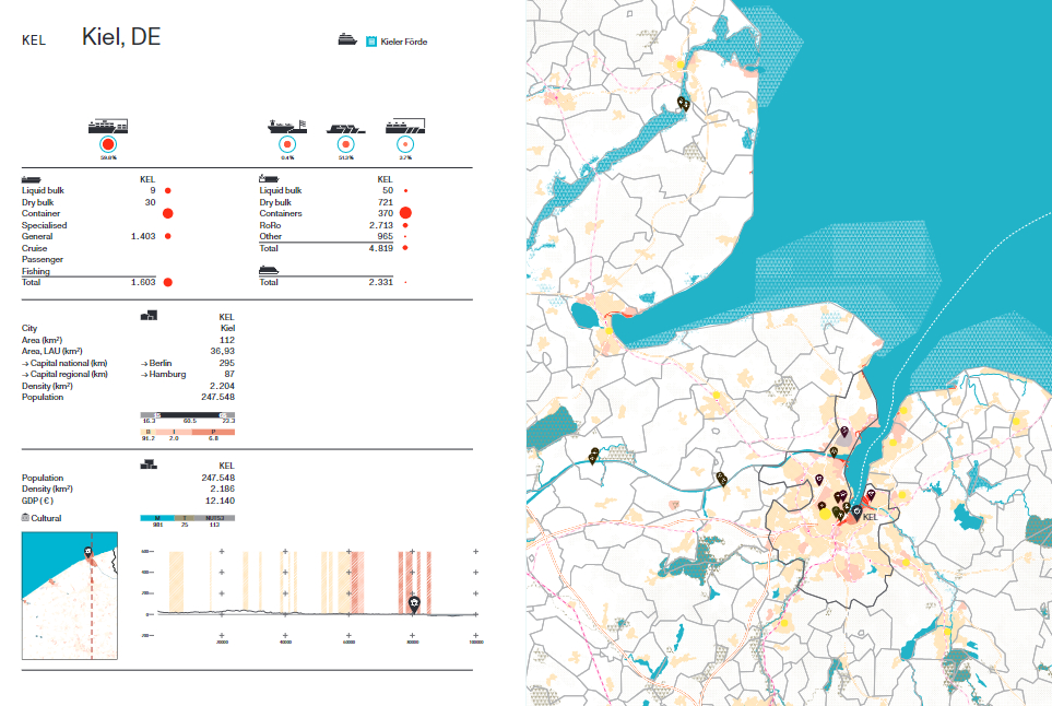
Kiel, as one of 100 port city territories visualized through maps and infographics (extract from © Port City Atlas).
Starting from which information, with which tools and methods, were the territories of the 100 port cities selected for the purposes of your research mapped?
The atlas visualises the port city territory through the spatial extent of the port itself, the built-up area in and around the port, the infrastructure and the hinterland, with indications relating to health, education and governance institutions. To map 100 port city territories, we used open access data from the European Commission and chose a scale that is independent of institutional boundaries and capable of examining a larger area. We have chosen to map these areas at the same scale, using both morphological and functional aspects to highlight their common typology, while exploring the unique needs and opportunities of each. Each map is accompanied by an infographic page containing data on the waterfront, detailed information on the port (e.g. data on vessels, port functions, number of passengers, types of cargo), on the port city (e.g. percentage of built-up area, industrial area, port area, number of people living in the area) and on the port city territory (e.g. geography, demography).
A partire da quali informazioni, con quali strumenti e metodi, sono stati mappati i territori delle 100 città portuali selezionati ai fini della vostra ricerca?
L’atlante visualizza il territorio della città portuale attraverso l’estensione spaziale del porto stesso, l’abitato e l’ambito limitrofo al porto, le infrastrutture e l’entroterra, con indicazioni relative alle istituzioni sanitarie, educative e di governo. Per mappare i territori delle 100 città portuali abbiamo utilizzato i dati ad accesso aperto della Commissione Europea e scelto una scala indipendente dai confini istituzionali e in grado di prendere in esame un’area più ampia. Abbiamo scelto di mappare queste aree alla stessa scala, utilizzando sia le caratteristiche morfologiche che funzionali in modo da evidenziare la loro tipologia comune, esplorando le esigenze e le opportunità uniche di ciascuna. Ogni mappa è affiancata da una pagina infografica contenente dati sul waterfront, informazioni di dettaglio sul porto (es. dati su navi, funzioni portuali, numero di passeggeri, tipologie di carico), sulla città portuale (es. percentuale di superficie edificata, zona industriale, area portuale, numero di persone che vivono nell’area) e sul territorio della città portuale (es. geografia, demografia).
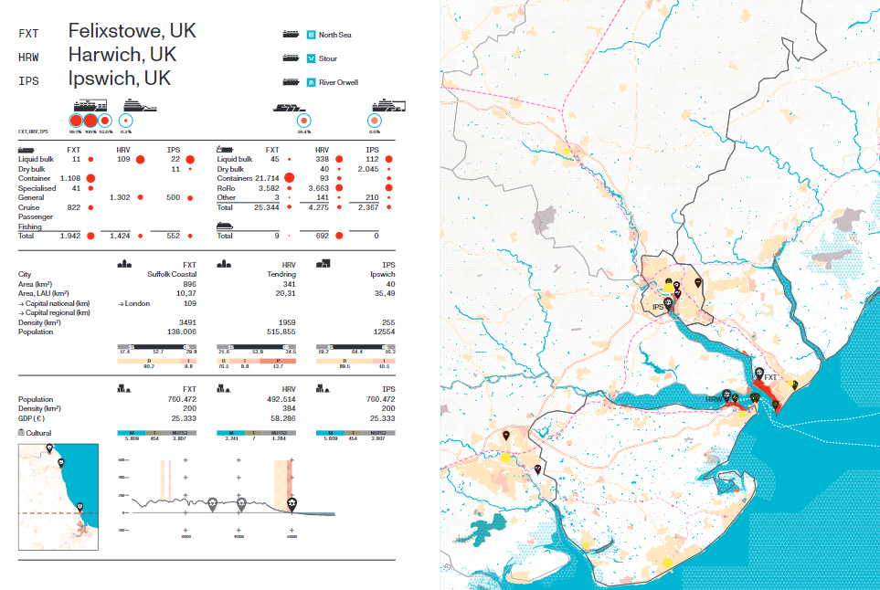
Example of map accompanied by the infographic page containing data on port city territories (extract from © Port City Atlas).
Could this new methodological approach be implemented further? What are the possible future applications of your research?
The Port City Atlas presents a new way of looking at port cities and is the first in a series of maps of port territories. A second volume will explore the social, environmental and spatial relationships in port city territories on rivers and canals, which are important inland links. As a next step, this methodology can be used as a basis for exploring how historical events have shaped contemporary development patterns in different port city territories; or for citizen engagement to develop common approaches to supporting ports that serve nearby territories as well as distant forelands and hinterlands.
Questo nuovo approccio metodologico potrebbe essere ulteriormente implementato? Quali sono le possibili applicazioni future della vostra ricerca?
Port City Atlas propone un nuovo modo di guardare alle città portuali ed è la prima di una serie di mappature dei territori portuali. Un secondo volume esplorerà le relazioni sociali, ambientali e spaziali nei territori delle città portuali affacciate su fiumi e canali, che costituiscono importanti collegamenti interni. Come step successivo, questa metodologia può essere utilizzata come base per esplorare in che modo gli eventi storici hanno modificato i modelli di sviluppo contemporaneo in diversi territori delle città portuali; o per l’impegno dei cittadini a sviluppare approcci comuni per sostenere i porti che servono i territori vicini, così come le terre lontane e l’entroterra.
BOOK Info
Carola Hein, Yvonne van Mil, Lucija Azman-Momirski
Port City Atlas.
Mapping European Port City Territories: From Understanding to Design
NAI010 Publishers; June 2023
Pag. 320
ISBN 978-94-6208-742-2
Authors’ Biographies
Carola HEIN
Carola Hein is Professor and Head of the Chair of History of Architecture and Urban Planning at the Delft University of Technology and Professor at Leiden and Erasmus University. She holds the UNESCO Chair of Water, Ports and Historic Cities and leads the LDE PortCityFutures Centre. She has published widely in the field of architectural, urban and planning history, tying historical analysis to contemporary development. Among other major grants, she received a Guggenheim and an Alexander von Humboldt fellowship. The latter resulted in her edited book Port Cities: Dynamic Landscapes and Global Networks (Hein, 2011) where she first proposed the concept of the spatial impact of port related flows on cities and territories, the PortCityScape. Over the next decade, she continued her work on commodity flows in port cities and territories, focusing on the importance of long-term development and path dependencies. Following her appointment as professor at Delft University of Technology in the Netherlands in 2014, she combined her interest in port cities with the GIS-based research tradition of the Chair History of Architecture and Urban Planning. Her article ‘Oil Spaces: The Global Petroleumscape in the Rotterdam/The Hague Area’ (Hein, 2018) describes the close link between water and oil. The co-edited book Urbanisation of Sea (Couling, Hein 2020) and the recent books The Routledge Planning History Handbook (2018), Adaptive Strategies for Water Heritage (2020), and Oil Spaces: Exploring the Global Petroleumscape (Hein 2021) analysing the close link between shipping, water, oil and ports set the stage for an atlas exploring and visualizing maritime flows on ports, cities and territories. Her many honours include the Sarton Medal in 2020, awarded to an outstanding scholar in the history of science.
Yvonne VAN MIL
Yvonne van Mil is a Researcher and Cartographer at the Delft University of Technology at the Chair History of Architecture and Urban Planning, and the Chair Complex Projects. Her research interests lie in spatial history and spatial planning, and specifically in regional development and geospatial mapping. She is co-author of several books, including Driven by Steel. From Hoogovens to Tata Steel 1918-2018 (2018), Atlas van het Westland, 10.000 ruimtelijke ontwikkeling (2016), and contributed chapters to the Atlas of the Dutch Urban Landscape (2014) and Atlas van de Schie. 2500 jaar werken aan land en water (2016). She has always been fascinated by ports, and joined the discussion on port cities professionally when she started working with Carola Hein in 2019. Her passion for maps and mapping as a means of studying and communicating spatial processes and expertise in systematic, spatial analyses led to shared publications on mapping and port city territories, and has paved the way for the Port City Atlas. Her co-authored articles include ‘Towards a Comparative Spatial Analysis for Port City Regions Based on Historical Geo-spatial Mapping’ (2019) (with Hein) and ‘Straddling the Fence: Land Use Patterns in and around Ports as Hidden Designers’ (2021) (with Hein and Ažman-Momirski).
Lucija AZMAN-MOMIRSKI
Lucija Ažman-Momirski is Associate Professor of Urban Design at the University of Ljubljana. Her research interest is the spatial development of port city territories. She has explored port expansion in studies of the Port of Koper and the city of Koper. Lucija Ažman-Momirski won the design competition for that port’s new master plan in 2007. She was the project leader for drafting professional guidelines in the spatial reorganisation of the Port of Koper, Slovenia, from 2007 to 2011; this work also won the International Maks Fabiani Award in 2015 and International Urban Planners Exhibition Award in 2015. She has expanded her work on port cities to education and research, publishing ‘The Resilience of the Port Cities of Trieste, Rijeka, and Koper’ in a special issue of The Journal of Urban History on port cities and resilience. Her (co-)authored published research papers include ‘Shifts in Governance: Who Governs and What is Governed in the Port of Koper’ (2020), ‘Straddling the Fence: Land Use Patterns in and around Ports as Hidden Designers’ (2021) (with Van Mil and Hein) and ‘Port City Resilience: Piloting a socio-spatial method for understanding, comparing and representing linked maritime heritage’ (2022) (with Hein and Van Mil).
Mapping Team
Stephan Hauser, Lukas Höller, Douwe de Jager, Hülya Lasch, Yvonne van Mil, Batuhan Özaltun, Myrthe Peet, Mees van Rhijn.