The location of coastal settlements had been advantageous for the transferring of goods from one place to another throughout the history. The interaction between different cultures and growing trade as well as the improvements in transportation technology and warehousing facilitated emergence of different attitudes towards the shaping of the port areas. Following the industrialization, many European cities began to invest in port areas in order to give response to the rapid commercial and industrial growth (Palmer, 1999). Since then, the port areas had been the essential parts of the urban structure, and development, but also the urban heritage. They ran through significant changes after their remarkable growth during the 19th century. This study questions how the port heritage gave effect to shaping of urban space in the waterfront development of coastal settlements. The special focus is shed on the Turkish port cities, Istanbul, Izmir and Mersin.
Redevelopment of port areas
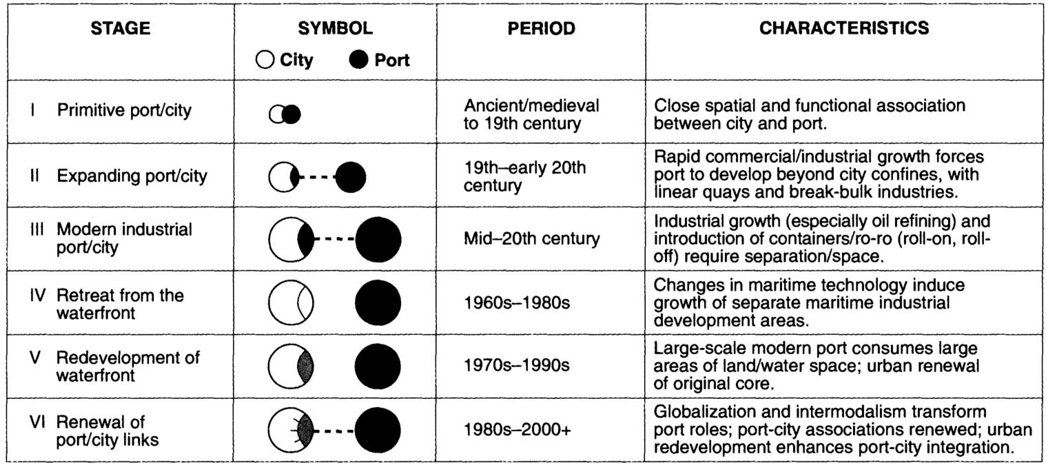
The port-city evolution model (Hoyle 1988, Hoyle 2000) (see following image) is conducive to develop explanations on reshaping of waterfront areas in a historical perspective. It simply reflects the processes and phases of waterfront development in relation to patterns of urban change. In their historical development, the city and the waterfront were in an organic relationship during the nineteenth century, in which the waterfront was characterized by plenty of piers alongside the linear quays. By the end of the nineteenth and early twentieth centuries, many port cities experienced expansion of docklands along the waterfront since new spaces were required due to the growing international trade. In this period, the port areas can be outlined as the historic waterfront of the port cities since the organic relationship between the city and the waterfront was retained, where the waterfront acted as an essential part of the urban structure and public space system.
Development of waterfront areas and the port-city interrelationship according to port-city model. (Source: Hoyle, 2000, p.405)
The post-war global transformation of maritime technology and transport required larger ships, more extensive land for the growing amount of cargo trades, and deep-water terminals for the larger ships to approach (Hoyle 2000, Palmer 1999). In this process, coastal-zone land reclamation provided area for necessary expansion (Hoyle, 2000). Since mostly the port facilities were moved from its initial location to somewhere else, port areas became subject to redevelopment programs, of which the first examples were widely seen in the North American cities. These programs included large-scale waterfront development, in which usually port facilities were transformed into different land use units, such as tourism, leisure, services and housing (Schubert, 2011). According to Hoyle (2000) these were the examples of first-generation waterfront development that spread to European port cities by 1970s. In the light of the “entrepreneurial model” (Harvey, 1989) of New Right policies in the UK, transfer of the production functions to other countries was followed through redevelopment of port areas. The port areas were seen as a marketable asset to attract international markets and foreign investments (Hubbard, 1995). High-quality residential and commercial developments were the particular indicators of port redevelopment programmes (Bell and Jayne, 2003). From this point of view, London Docklands, the largest port area in Europe that was abandoned during 1960s, were transformed into spacious and expensive commercial and residential places (Schubert, 2011). After London, many British port cities, such as Southampton, Portsmouth, Birmingham, Glasgow, Liverpool, Cardiff, Bristol and Manchester, experienced a similar development in their port areas (Jones, 1998). Redevelopment of port areas turned the places of production into the places of service and accommodation. This trend has been adopted in the waterfront redevelopment programmes at the turn to twenty-first century, which are conducted through public-private partnerships and professional management bodies (Schubert, 2011).
While the historic waterfront of the nineteenth-century port cities became subject to redevelopment programs in the second half of twentieth century, it was turned into a phenomenon of urban planning and design (Hoyle, 2000) that aim to reshape its form and functions, and redefine its relationship to the city. As the historic waterfront is conceived as derelict docklands, they evolved into places of mixed-use compositions, leisure activities (Desfor and Laidley, 2011). That is to say, the places of production are transformed into places of consumption as a result of redevelopment programs.
Waterfront development in the Eastern Mediterranean: Turkish port cities
The historic waterfront areas of Eastern Mediterranean port cities were shaped during their articulation to the growing global trade during the nineteenth century. In their relationship with the industrialized cities, they mostly acted as transfer points to convey the raw material from their hinterland to the port cities of central countries, such as Britain and France. Development of international trade resulted in construction of port areas and restructuring of urban form through foreign direct investments (Selvi Ünlü and Göksu 2018, Selvi Ünlü 2009). Many projects were produced in this period due to the need for modern docks and wharves, customhouses and storehouses (Hastaoglou-Martinidis 2010).
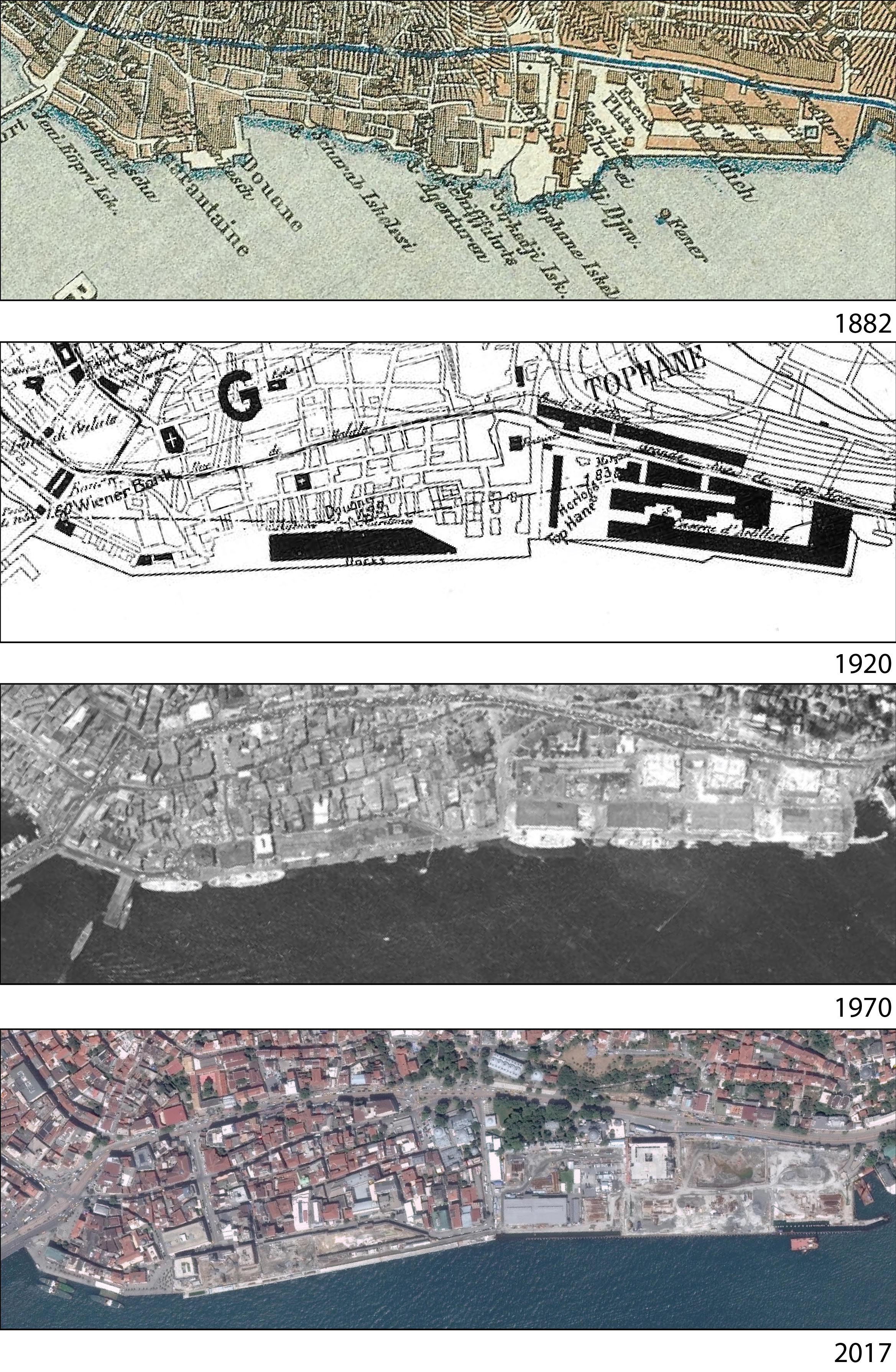
In this period, Istanbul was the capital of the Ottoman Empire, while it was also a historical port city. Golden Horn, the inlet of the Bosphorus Strait had been the main port area of Istanbul historically, due to its well-protected location. However, as the commercial and production uses developed in the Karaköy (Galata) region, to the north of Historical Peninsula, Karaköy quay became a substantial part of these activities, as well as the entire port system (Erbil and Erbil 2001). However, it was also an important place for the recreation activities during the nineteenth century. It was the departure point for an enjoyable ride in the Bosphorus by boats (Topçu 2017). The harbor works in Istanbul was governed by an Ottoman official, Marius Michel between 1892 and 1910 that resulted in a 758 meters-long quay and several buildings for customs, commerce and storage (Çelik 1993, Hastaoglou-Martinidis 2011). The port area was constructed through reclamation of land from the sea and stretched along the waterfront, in front of the old city (Kafesçioglu and Öncel, 2015) (see following image).
Development of Karaköy quay in 1882 (Source: lib.chicago.edu), 1920 (Source: Ifea), 1970 and 2017 (Source: sehirharitasi.ibb.gov.tr)
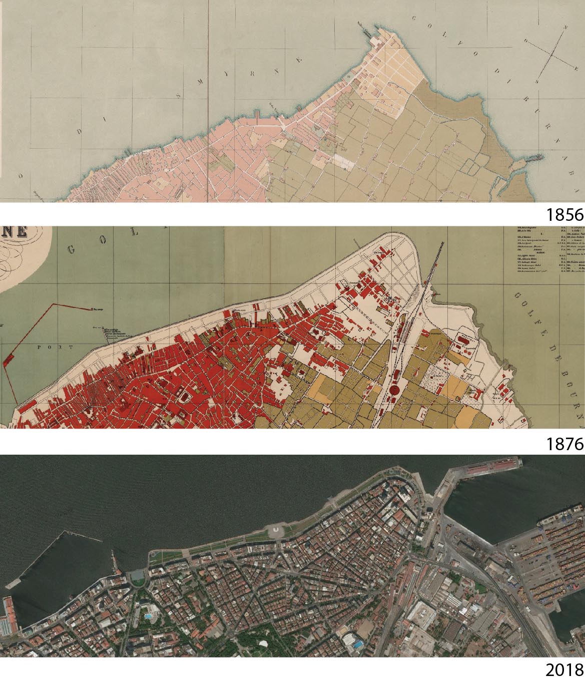
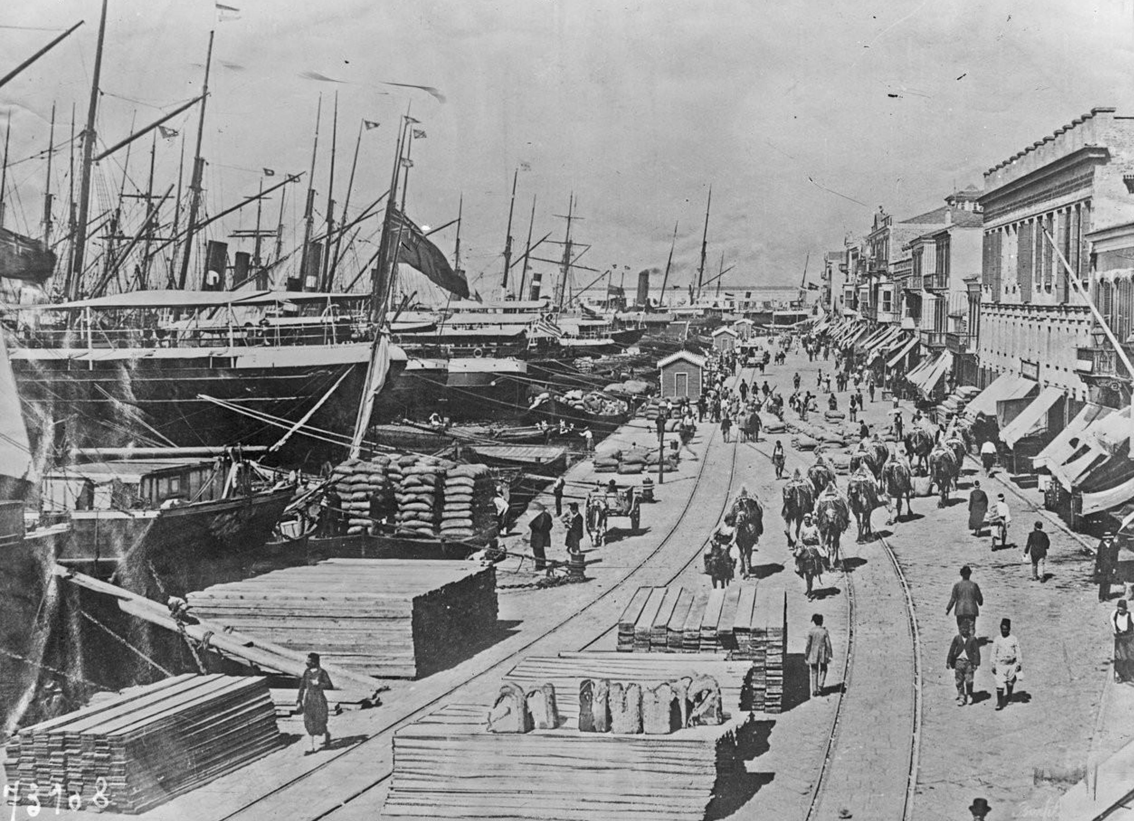
Due to the extensive development in international trade, Izmir had flourished as the most significant port city on the Aegean coast since 17th century (Gençer 2017), however its role in the commercial relations gained more importance during the 19th century, and resulted in a rigorous urban development. During this development, port area, consisting of several piers, stretching along the waterfront (see following images) was one of the significant elements of urban form. In 1863, a concession to build a quay in the place of these piers through landfill along the waterfront of the city was given to two English entrepreneurs, Charnaud and Barker. The concession was taken over by French Dussaud Brothers and construction of quay was finished in 1875 (Frangakis-Syrett 2001, Gençer 2017, Hastaoglou-Martinidis 2010). The 18 meter-wide quay was accommodating a dual-track tramline, combining the Customs House and the Railway Station to each other (Frangakis-Syrett 2001). Else, regular urban blocks were formed on which new commercial premises and public buildings were erected (Hastaoglou-Martinidis 2017) (see following images).
Izmir quay in 1856 Storari map (Source: https://gallica.bnf.fr), 1876 Saad Map (Source: http://luna.lib.uchicago.edu), and 2018 aerial photo.
Izmir quay in 1922. (Source: https://gallica.bnf.fr)
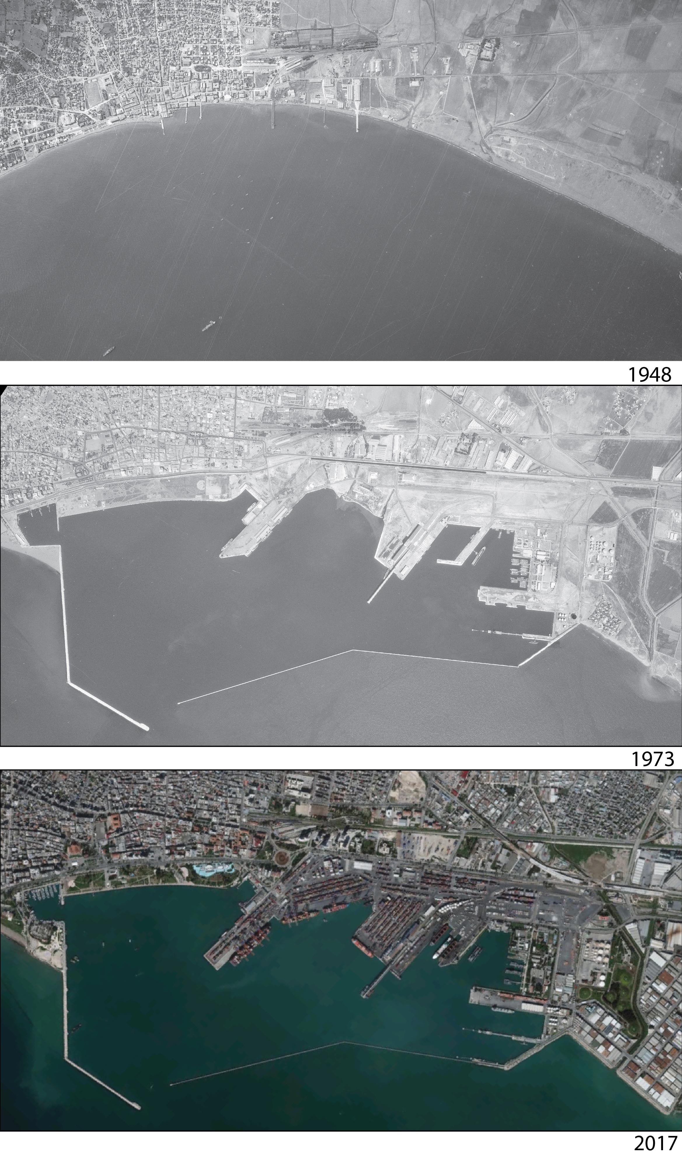
Similar to Izmir, the port area of Mersin was including several piers along the waterfront. They were connected to Uray Street, where the offices of international trade existed. Uray Street was also connecting the Customs Square and Customs Pier, the main square and pier of the city, to the railway station. Different from Izmir, although there were attempts to improve the port conditions, Mersin could not achieve completion of a quay along the waterfront, and the piers had existed until the construction of modern port area at the beginning of 1960s (Selvi Ünlü and Kayam, 2019) (see following image).
Mersin waterfront in 1948 and 1973 (Source: Archives of General Directorate of Mapping), and 2017 aerial photo.
New maritime technologies and needs of the post-war period resulted in withdrawal of historic waterfronts and moving to new campus-like port areas. New modern port areas of Mersin and Izmir were constructed in a distinct place to the city center, to the east and to the north, respectively. Besides having many storehouses inside the new port areas, the surrounding district also utilized warehousing facilities. Karakoy quay in Istanbul was used for storage purposes until 1980s, when they were taken over by Haydarpasa port. As a result, the historic waterfronts became subject to new interventions.
Eastern Mediterranean port cities experienced the large-scale waterfront redevelopment programs in 1990s, based on the large project to reutilize old port areas (Hastaoglou-Martinidis 2017). After relinquished cargo and storing facilities, Karaköy port area has served as a passenger terminal since 1986. Galataport project was firstly produced in the area in 2001, stretching 1200 meters along the waterfront (Topçu 2017). Before this project, Karakoy port was subject to a series of reorganization, beginning at the last decade of twentieth century, when international firms were invited to redesign the area as a tourism center (Erbil and Erbil 2001). In fact, it was a result of its declaration as Special Tourism Area by the central government. By this way, the control of the port area was transformed from the local planning authorities to central bodies. At the present day, the old storehouses have been destroyed, as well as the passenger terminal, and project to develop the area as a tourist attraction district is advancing.
After modern port areas of Izmir and Mersin were opened to operation in 1959 and 1962 respectively, the port-related facilities were moved from the historic waterfronts to the new modern campus areas, which are surrounded by walls. Since the historic waterfronts no longer performed in their original condition, they became the areas of new functions. The historic waterfront of Izmir became a promenade, associated with several restaurants until the beginning of 1990s, when a transit road was planned through reclamation of land from the sea, just in front of the promenade. Despite the resistances, the landfill development occurred partially. However the oppositions resulted in withdrawal of the transit-road idea and designing the area as a public park. In Mersin, the piers of the historic waterfront were destroyed in order to fill the area for the new port facilities. As a result, a landfill emerged, stretching along the historic city, between the city and the sea. Later, this area was designed as a public park, similar to the Izmir example.
Concluding remarks
Eastern Mediterranean port cities had run through redevelopment of historic waterfronts, which were developed as an essential element of their urban heritage, urban structure and public space system during the 19th century. Each city had their unique characteristics, although they experienced similar processes and phases. Mersin and Izmir examples revealed that the historic waterfronts were separated from the historic core of cities through the landfill developments, which stretched between the city and the sea. The landfill areas are used as public spaces, however in Izmir office, commercial and residential developments have been triggered in the old storage areas, associated with the port area. And a parallel decision is on the agenda of Mersin’s local planning authorities. On the other hand, the developments in Istanbul is much more similar to the examples in industrialized countries that resulted in transformation of historic waterfront into a touristic space. It is noteworthy to point out that the Galataport project is being realized through a public-private partnership model that is sine qua non of neo-liberal policies.
Since the waterfront areas have a high degree of visibility, their redevelopment is of interest to authorities, communities and developers (Hoyle, 2000). However, the approach utilized in these redevelopment programmes should be questioned whether the heritage of historical waterfronts is used in order to invoke images to attract foreign investments and to use the space as a commodity to facilitate capital accumulation, or it is used for improvement of public interest. The experience of Turkish cities revealed that they are in a process of articulation into the global networks through “entrepreneurial model” (Harvey, 1990) of the neo-liberal view. The heritage of cities is subject to intervention in order to attract money, rather than providing the citizens sustainable urban environments that are well integrated with the urban structure of cities.
References
Bell D and Jayne M (2003) Design-led Urban Regeneration: a Critical Perspective, Local Economy, vol 18, no 2, 121-134.
Çelik Z (1993). The Remaking of Istanbul. Berkeley, University of California Press.
Desfor G and Laidley J (2011) Introduction: Fixity and Flow of Urban Waterfront Change, in Desfor G, Laidley J, Stevens Q, Schubert D (eds) Transforming Urban Waterfronts: Fixity and Flow, Routledge, Oxon, pp 1-13.
Erbil AÖ and Erbil T (2001) Redevelopment of Karaköy Harbor, Istanbul: Need for a New Planning Approach in the Midst of Change, Cities 18(3), pp 185-192.
Gençer C (2017) Urban Transformation in Smyrna and Salonica in the 19th Century: Construction of Quays and Ports [in Turkish], Meltem 1: 33-51.
Frangakis-Syrett E (2001) The making of an Ottoman port The quay of Izmir in the nineteenth century, The Journal of Transport History 22(1), pp 23-46.
Harvey D (1989) From managerialism to entrepreneurialism: the transformation in urban governance in late capitalism, Geographska Annaler, 71B, pp. 3–17.
Eastern Mediterranean cities: Technical and Urban Modernization in the Late Nineteenth Century, in Kolluoğlu, B. and Toksöz, M. (eds) Cities of the Mediterranean from the Ottomans to the present day, London, Tauris, pp. 78-99.
Hastaoglou-Martinidis V (2011) The building of Istanbul docks 1870-1910. New entrepreneurial and cartographic data, ITU A/Z 8(1): 85-99.
Hastaoglou-Martinidis V (2017) Historic Harbors of Eastern Mediterranean Cities:The Challenges of Enhancement, in Porfyriou H and Sepe M (eds) Waterfronts Revisited, Routledge, Oxon.
Hoyle B (1988) Development Dynamics at the Port-City Interface, in Revitalising the Waterfront: International Dimensions of Dockland Redevelopment, edited by B. S. Hoyle, D. A. Pinder, and M. S. Husain, 5-19. Belhaven, London and New York.
Hoyle B (2000) Global and Local Change on the Port-City Waterfront, Geographical Review, 90 (3): 395-417.
Hubbard P (1995) Urban design and local economic development: A case study in Birmingham, Cities 12 (4), pp. 243-251.
Jones A (1998) Issues in Waterfront Regeneration: More Sobering Thoughts-A UK Perspective, Planning Practice & Research, 13:4, 433-442.
Kafesçioglu F, Öncel AD (2015) The impact of sea walls on the form of coastal settlement in Galata and investigation of this impact on current pattern, Bas Y and Burat S (compiled by) 1st Turkish Urban Morphology Symposium: Approaches and Techniques, Center for Mediterranean Urban Studies, Mersin, pp 115-146.
Palmer S (1999) Current port trends in an historical perspective, Journal for Maritime Research, 1(1), pp 99-111.
Schubert D (2011) Waterfront Revitalizations From a Local to a Regional Perspective in London, Barcelona, Rotterdam and Hamburg, in Desfor G, Laidley J, Stevens Q, Schubert D (eds) Transforming Urban Waterfronts: Fixity and Flow, Routledge, Oxon, pp 74-97.
Selvi Ünlü T (2009) Bir Iskeleden Liman Kentine Dogu Akdeniz’in Önemli Bir Limanı Olarak On Dokuzuncu Yüzyılın Ikinci Yarısında Mersin’de Mekansal Gelisim [Development of Urban Form of Mersin during the second half of nineteenth century]. Planlama (3/4):5–26.
Selvi Ünlü T, Göksu E (2018) Osmanlı’dan ulus devlete Dogu Akdeniz liman kentlerinde mekana müdahale ve kent kimligindeki degisim: Mersin ve Volos örnegi [Changing urban identity in the Eastern Mediterranean port cities from the Ottoman period to the nation states: The case of Mersin and Volos], METU JFA 35(1): 51-88.
Selvi Ünlü T, Kayam M (2019) The Port of Mersin from the Nineteenth Century to the Twentieth Century in Yenisehirlioglu F, Özveren E, Selvi Ünlü T (eds) Eastern Mediterranean Port Cities: A Study of Mersin, Turkey—From Antiquity to Modernity, Springer, Cham, pp. 154-177.
Topçu H (2017) Transformation process of Galata Port in Istanbul: Reflections on the impacts of Galataport project, in Porfyriou H and Sepe M (eds) Waterfronts Revisited, Routledge, Oxon.
Head Image: The waterfront of Mersin.
