╔
Introduction
Ecodistrict concept is an innovative approach to urban planning for new neighbourhoods that has been deployed in many ways internationally since the end of the 20th century. In the context of climate change and the increase in the frequency and intensity of natural disasters, the way urban centres have been planned since the 20th century is undergoing profound transformation. There is a transition from hard to soft engineering (Nucci, 2022; Nyka et al., 2021) and in urban design, the notions of time and change are integrated into urban planning to address the complexity and unpredictability of future challenges in the era of climate change (Feliciotti et al., 2016; Romice et al., 2020). In the Canadian context, ecodistricts present new urban environments. This paper aims to discuss how such districts, in port cities under transformation, may contribute to the resilience of the living environment and their communities. And under which circumstances their adaptation to climate change can be increased? To do so, it is appropriate to look at two geographically interconnected cases of urban transformation in Quebec City: the case of the St. Charles River linear park and the ecodistrict of Pointe-aux-Lièvres.
The new urban design of the St. Charles River linear park and the urban development of ecodistrict of Pointe-aux-Lièvres are relevant cases of innovative new urban waterfronts. On the one hand, they assess climate change facing the consequences of flooding, sea-level rise and storms. On the other hand, they are examples demonstrating the potential for transformation of a site from an industrial sector to the outskirts of the city in the 20th century to an urban area in the heart of the city’s central neighbourhoods in the 21st century.
Divided into three sections, the paper presents an analysis of the recent transformations in the lenses of climate change to review the decisions made to mitigate the climatic vulnerabilities and increase urban resilience. First, a short review of theoretical background introduces the St. Charles River as a topic of interest, the improvement of urban resilience brought by a transition from hard and soft engineering and finally the concept of ecodistrict. Second, a portrait of the geomorphological conditions of the Quebec City riverfront area examines more specifically the mouth of the St. Charles River. Third, the case studies provide a critical look at anthropogenic actions carried on the natural environment. Finally, the paper discusses how the protection of vulnerable waterfront areas depends on the implementation of solutions that integrate complex systems and find new strategies to adapt and mitigate.
Background
St. Charles River, as an Urban Morphological Research Topic
The St. Charles River has been the subject of some recent studies in urban morphology. Dufaux and Lemieux-Audet (2017) studied the river and its access with particular interest in the road network space syntax. Authors tested scenarios of new pedestrian bridges linking Pointe-aux-Lièvres to its neighbourhoods. Also, the growing risk of rising waters in the harbour sector of the city has been analysed through the requalification of industrial and waterfront brownfields. Literature does not look to recent experiences trying to integrate innovative solutions and strategies to adapt and mitigate.
Resilience in Urban Form: From Hard to Soft Urbanism
To face actual and future economic, cultural and climate change, urban environment must adapt at multiple scales. It evokes irrevocable resilience through change and time (Feliciotti, 2018; Romice et al., 2020) from building to the city scale. Urban area deals as a fundamentally complex system. The complexity induced by the natural environment in which the urban environment is inscribed is facing new challenges. According to some authors, conventional urban planning based on controlling urban environment is now impracticable: “Masterplanning is dead” (Scheer, 2013) and “Town Planning versus Urbanism” (Hebbert, 2004). In contrasts, Feliciotti and al. (2016, p. 23) propose to design the city as “an inherently moving target”. They suggest an idea of the city as a trajectory of change and not as a model to achieve. This conceptual framework is in line with the actual transition taking place from hard to soft engineering. In that sense, Moretti (2023) looks towards “inhabiting the in between” to face landscape and urban design challenges in the era of climate change.
Throughout the 20th century, urban planning mainly implemented infrastructure using methods of hard engineering. Especially regarding water management in urban areas, conventional urban planning used strategies to control nature. The tools put in place included controlling water, both rainwater and urban streams, with mechanical drainage measures. At present, this leads to high construction and maintenance costs and incapacity to deal with new climatic patterns.
The new paradigm for the 21st century relies on a transition to soft engineering which requires a permanent negotiation with nature. To mitigate the challenges brought by natural disasters, urban design needs to develop strategies to adapt to nature and prevent its risks. This is a more ecosystem-based urban approach to metabolise water and pollutants on site, restore wetlands rather than draining elsewhere: from mechanical to biological. Scholars illustrate the paradigm shift by presenting the design of water management systems from “drain, direct and dispatch” to “slow, spread and soak” (Nucci, 2022). Soft engineering is a homologue concept to “Low-impact development” (LID) that is generally looking to more sustainable solution to urban stormwater management.
Ecodistrict
Major urban transformation projects have emerged in the early 2000s in Europe, notably in Sweden – Hammarby Sjöstad et Norra Djurgårdsstaden in Stockholm – and Germany – Vauban à Fribourg-en-Brisgau et Scharnhaussser Park in Stuttgart. Increasing importance is given in the literature to the transformation of vacant, abandoned, or underused urban plots (Tesoriere & Lecardane, 2015), former industrial sites (Benali, 2012), military (Vivre en ville, 2014a) or railways (Merzaghi & Wyss, 2009).
The basics of ecodistrict present a consensus on environmental considerations and on the protection of natural environments, the reduction of greenhouse gas emissions and energy efficiency (Vivre en ville, 2014b). There is a particular interest in social issues including local governance and citizen consultation (Mercier et al., 2016). In terms of how to implement these innovative neighbourhoods, there are as many models as projects. The next section will show how Quebec City has implemented its vision on its own urban landscape.
Case study
Quebec City Riverfront (1608-1950): First Human Settlement to Modernism
Quebec City is located on the north shore of the St. Lawrence River, 600 kilometres inland from the Gulf of St. Lawrence. Despite its distance from the sea, the city has a maritime character by virtue of its location at the furthest point upstream to experience significant tides, which can reach more than five metres one third of the year.
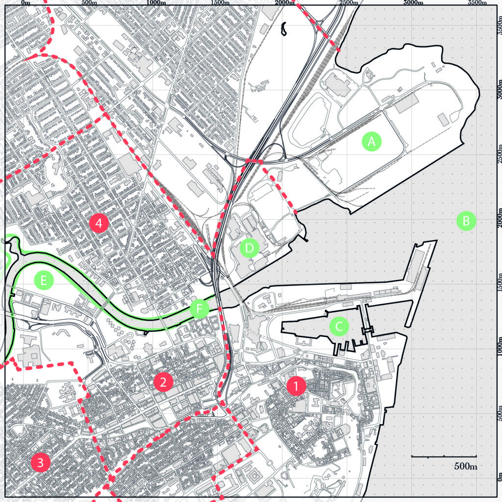
Map of Quebec City in 2020
Points of interest:
A: Port of Quebec,
B: St. Lawrence River,
C: Louise Basin,
D: Pulp and Paper Mill,
E: Pointe-aux-Lièvres,
F: St. Charles River linear park.
Neighbourhoods:
1: Old Quebec City, 2: St. Roch,
3: St. Sauveur,
4: Limoilou.
(Nadon-Roger, 2021, fig. 2) (Reproduced by permission of its author © All rights reserved.)
Geomorphological conditions determine a site’s natural capacity for absorbing water and therefore its susceptibility to flooding. Steep hills in Quebec City rise to a pair of plateaus on either side of the narrow plain that separates Cap Diamant from the Canadian Shield. The city’s development began along the ridge that provided easy and continuous access to both the St. Lawrence and St. Charles rivers. In the 17th century, a citadel and fortified town were built at the eastern end of Cap Diamant, which rises to 100 metres above sea level.
In the 19th century, urban development began to spread along the St. Charles River. The St. Roch and St. Sauveur neighbourhoods grew apace with the activity of the adjacent shipyards and port.
Until the early 20th century, this largely residential piece of the city’s ‘basic fabric’ remained confined to the area between the cliff and the St. Charles River. During the same period, backfilled land was used for industrial activities at the port and for specialised structures built to support the city’s role as a centre of production (previous image).
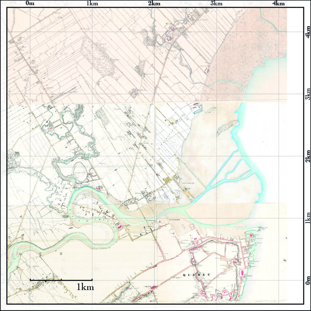
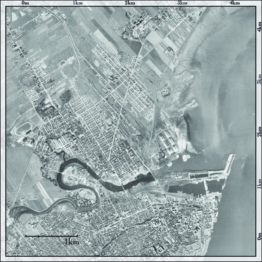
Left: Quebec City in 1865 (Fortifications Survey, BANQ Detail notice: P600,S4,SS2,D635); Center: Quebec City in 1948 (Aerial photography, Ville de Québec. Engineering Department. Survey and Mapping Division, Archives extracted from GeoStat Centre at Laval University); Right: Quebec City in 2000 (Topographic Map, BANQ Detail notice: 0002683907).
(Nadon-Roger, 2021, fig. 3) (Three images are reproduced by permission of its author © All rights reserved).
The construction of a pulp and paper mill at the mouth of the St. Charles River in 1928 marked the beginning of a new phase of urbanisation, one associated with growing industrialisation. Nevertheless, as late as 1948, urban development on the river’s north shore remained limited to a one-kilometre radius (previous image). The St. Charles River was known at the time in the community as an open-air urban sewer, a polluted and neglected river. The condition was correlated with the public hygiene practices of the time, but especially to the nearby port and industrial activity which was not subject to environmental regulations.
St. Charles River Transformed Based on Hard Engineering (1950-1995)
During the second half of the 20th century, technological advances and growing prosperity inspired new efforts to control the urban landscape, including water management projects (next image).
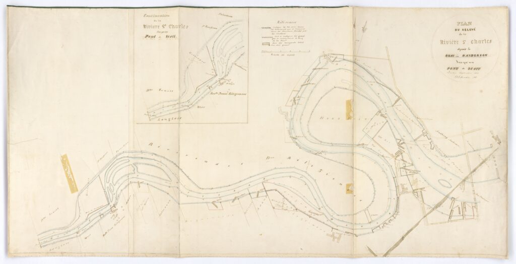
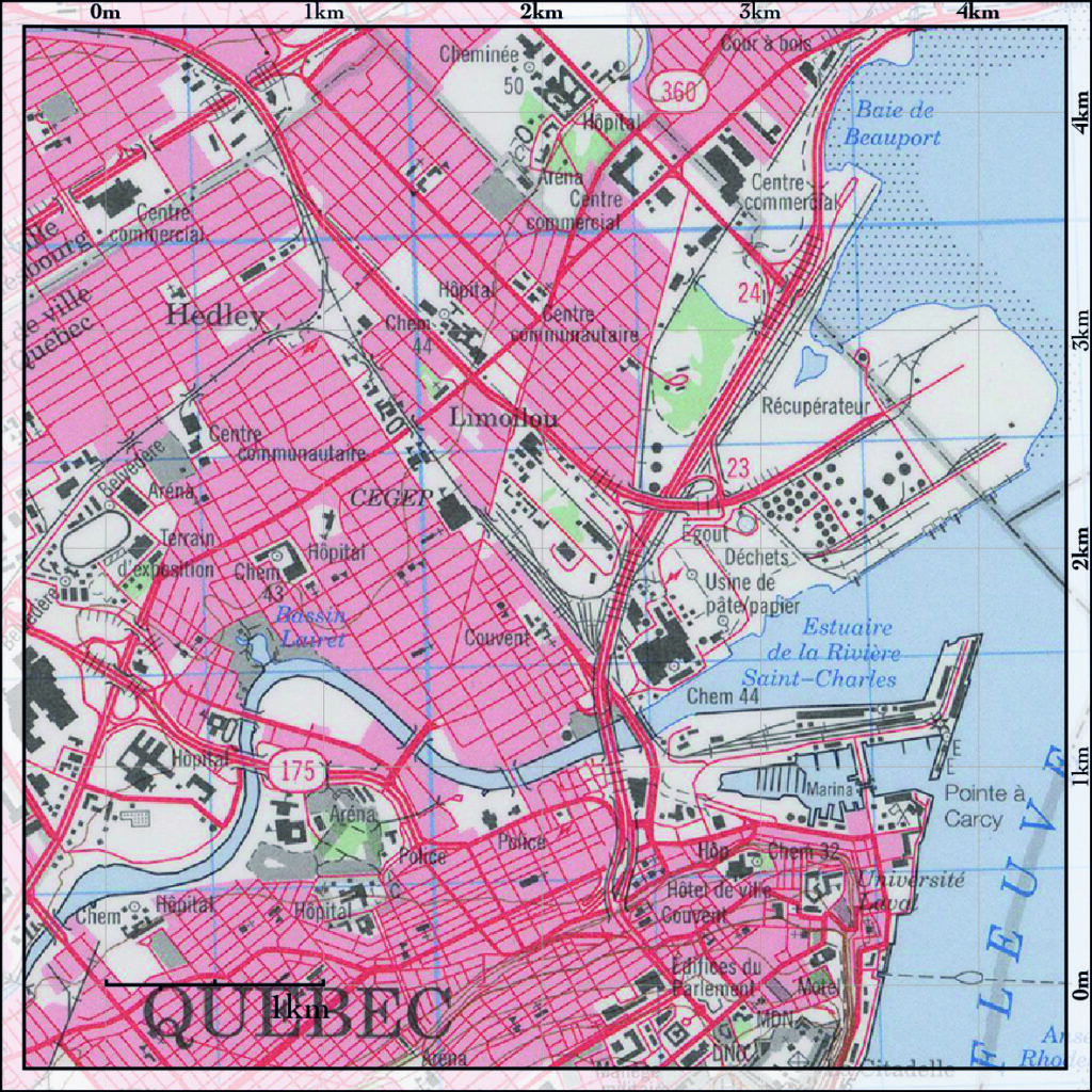
Map survey of St. Charles River from Anderson’s wharf to Scott Bridge (October 1854. Source: Fonds Ministère des Terres et Forêts – National Archives in Quebec City. Archive listing: E21,S555,SS1,SSS22,P33).
In Quebec City, the St. Charles River shores were lined with concrete in the name of public hygiene. The meander that had encircled Victoria Park near the end of the tidal reach was cut off and filled in, dramatically altering the surrounding topography (next image).
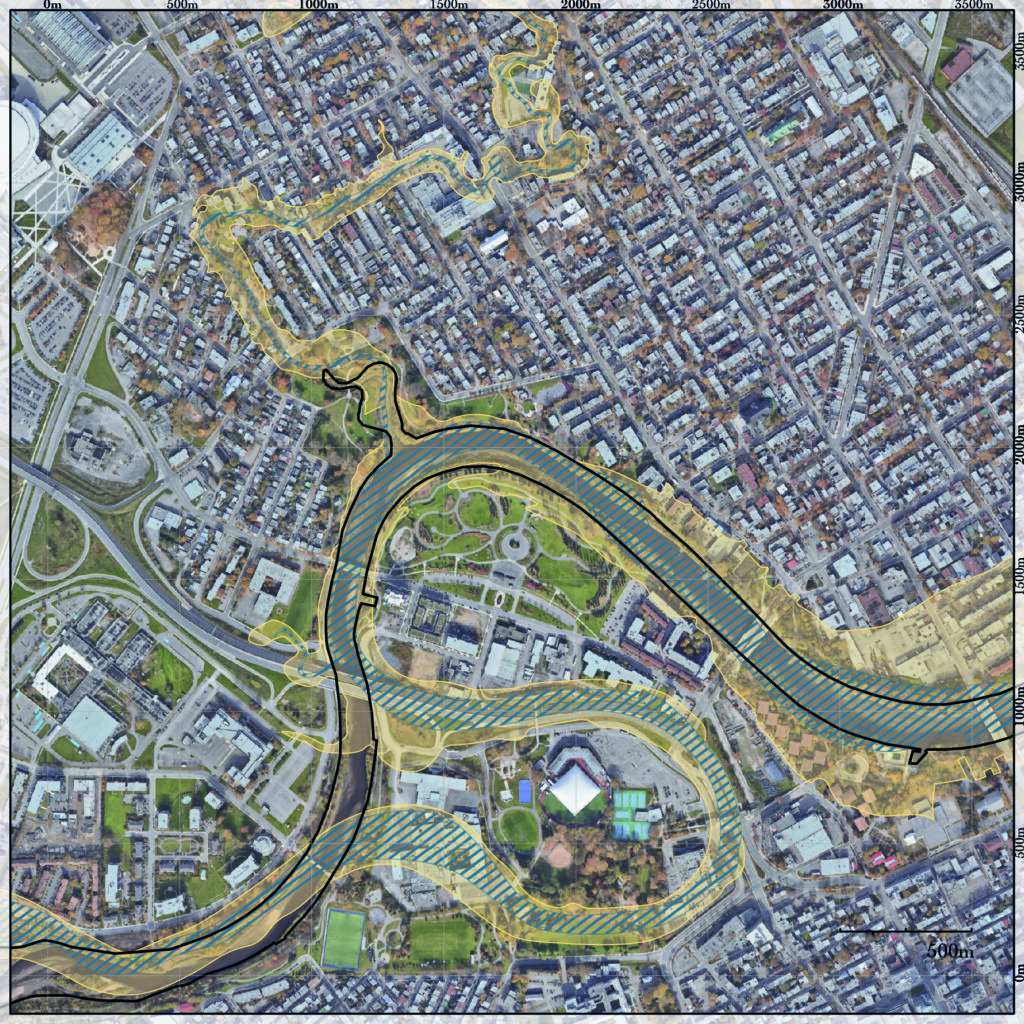
Anthropogenic impacts in the 1960s. The map shows a comparative view of the shoreline in 1865 and in 2020 (Blue: high tide in 1865; Yellow: low tide in 1865; Black: controlled water levels in 1960). Note the cut off meander on the south shore of St. Charles River and the covering over of the Lairet River to the north (Nadon-Roger, 2021, fig. 6). (Reproduced by permission of its author © All rights reserved).
These changes allowed for the construction of the initial segment of the Autoroute Laurentienne (1956-1963). Burying a shoreline that was once submerged at high tide, this motorway links the city centre to the north and creates an urban barrier isolating the park and the surrounding lands. Meanwhile, the Lairet River was covered over, although its path remains visible in the street layout of the Limoilou District. Indeed, the originally organic and spontaneous course of these waterways, which had provided protection against spring flooding, stands in stark contrast to the grid layout applied to the surrounding neighbourhood.
By 2020, following 155 years of urban development, the area covered by the waterways at the mouth of St. Charles River had been reduced by 52 percent [1]. This reduction is largely due to the lining of riverbanks and wharves, as well as the removal of a shoal during the construction of the Autoroute Dufferin-Montmorency (a motorway linking the city centre to the east). Only a modest 28.9 hectares of riparian buffer strips remain in Pointe-aux-Lièvres Park on the St. Charles River and in the Maizerets neighbourhood on Beauport Bay.
Riverbanks Renaturalization Based on Soft Engineering (1995-2005)
In the mid-1990s, a citizen-based movement began the naturalisation of the Saint-Charles River. Quebec City conducted public consultations and integrated the needs of the local communities. The banks that had been concreted under the hard engineering paradigm in the 1960s were then renaturalised for seven kilometres through central neighbourhoods. The integration of abundant vegetation and wetlands ensures soil permeability. In addition, a pedestrian and multi-use trail was built as a linear park allowing citizens one of a king green and blue space and enjoy nature in the city. This is an eloquent example of a transition from hard to soft engineering.
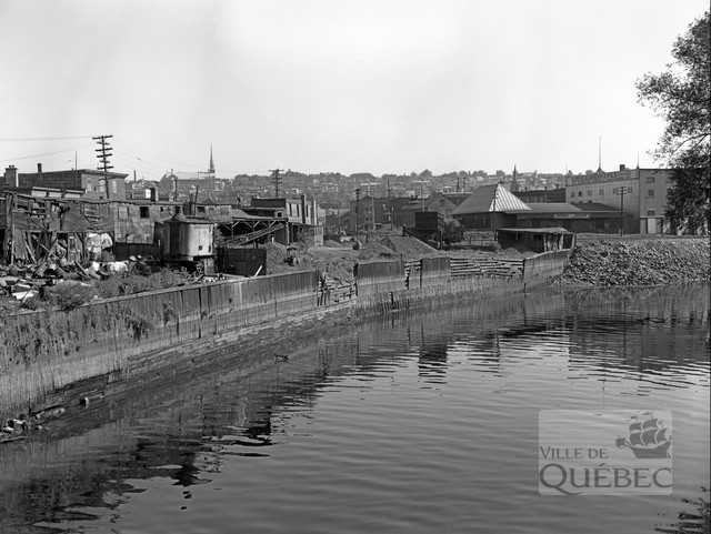
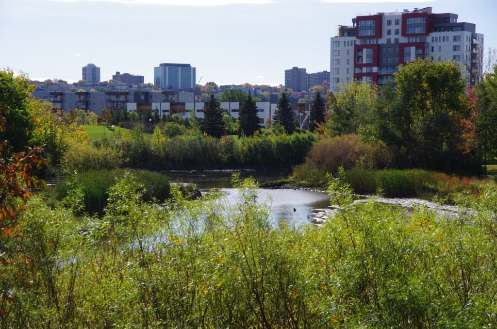
Above, a photograph of the Saint-Charles River and a coal merchant (August 1952. Source: Municipal Archives of Quebec City. Archive listing: Q-C1-14-N0023-N002340). Below, recent picture from taken from the Parc de l’Anse-à-Cartier toward Pointe-aux-Lièvres and the St. Charles River (Source: Vivre en Ville, image reproduced with the permission of its author © All rights reserved).
The last 20 years of soft engineering along the urban stream including renaturalising the shorelines promoted biodiversity and regenerated ecosystems. It has provided access to the river for the local citizen, it has relied on participatory and active modes of governance, it transformed high risk of flooding into a biodiversity corridor. Finally, the development of these new wetlands increased urban resilience of the sector while enhancing a symbiosis with the nature.
Pointe-aux-Lièvres Ecodistrict (2005-Today)
In the early 2000s, Quebec City owned vacant or underused mega-plots in areas near the city centre: Pointe-aux-Lièvres and Pointe-D’Estimauville, further east of the city [2]. Both sites are being requalified because of the decline that led to the sector’s vacancy, the first industrial and the second commercial.
In 2009, Quebec City announced the development of two ecodistrict projects for both sites in partnership with the private sector. In 2011, it granted the development contract to a real estate developer who had the responsibility for the development of both neighbourhoods. It sets up a “Programme particulier d’urbanisme” (PPU) for each of the two concerned sector which embedded those two districts. The objective of these plans was to frame the work of this single constructor through a process of citizen consultations. However, the collaboration proved inoperative and in 2013 the developer was released from his duties while the City decided to take over the subdivision, the construction of infrastructure. They decided to sell the plots separately to different intermediate developers.
Beyond the process of citizen consultation and consideration of community issues in the Pointe-aux-Lièvres urban transformation project, this is a matter of real estate development for Quebec City (Mercier et al., 2016, p. 5). For ten years now, municipal authorities have not hidden the real estate development potential of these neighbourhoods. The City promotes land that is of interest to developers in terms of its relative position in the city. It sells the land on the condition that the proposed project meets the City’s criteria for the development.
Evaluation Criteria for Residential Construction Projects at Pointe-aux-Lièvres
In the municipal literature (Ville de Québec, 2019) [3], an ecodistrict is defined by an inclusive living environment, by innovative environmental practices and as an effective way for construction of new housing and services (Ville de Québec, 2019, p. 6). For this purpose, 27 criteria are oriented according to 7 different themes: the measurement of the ecological performance of buildings (1), the characteristics of dwellings (5), the relations to public space (3), the urban and architectural composition (8), parking (6) and landscaping (4).
The analysis of the execution of those criteria are listed but not discussed in detail. The qualitative and project-based approach demands a different regulation framework alternative to the typical zoning system. Nonetheless, some criteria are in fact bearers of innovative practices. For example, green performance is validated by the requirement that projects receive LEED Home certification. At the dwelling level, criteria frame the way typologies are distributed by the plot, their size, and the number of rooms. Relations with the public space are interesting, in the way that the dwelling at the ground floor must have private access from the public space. Also, reduced setbacks provide a desirable frame from a street urbanity perspective. The criteria of urban and architectural compositions emphasise ecological materials, green roofs, and waste management. Some criteria relate to the integration avec green spaces and regulate the minimum green area for each parcel.
Discussion
To discuss the results of this study, we look at four different scales of intervention: neighbourhood, street, plots, and buildings.
At the neighbourhood scale, the transformation of the St. Charles riverbanks in the late 1990’ sets the terms of an urban transformation that enhance a symbiosis between the stream itself and the neighbourhoods. It demonstrates how a former urban barrier can become a link between multiple communities. It confirms the innovative interest for an urban planning approach based on subtraction and requalification of urban brownfields. It demonstrates how a transition from mechanical to biological way to manage water helps to limit flood damage. It also shows how the Autoroute Laurentienne still limits the connectivity between Limoilou District, Pointe-aux-Lièvres District and the Parc Victoria. Good practices in urban transformations have a multiplier potential when well connected to other urban nodes. Despite the quality of its park-wide layout, the development and connectivity of the ecodistrict are still limited by the highway urban barrier.
At the street level, the new district improves the ecological footprint by making innovative environmental practices one of the main objectives. However, car-oriented strategies still regulate the building form using the size of underground parking to define access from the street. The way urban form in organised for automobiles jeopardise accessibility to dwellings and public life. It has consequence effect on the vicinity.
At the scale of the plot, smaller plots are more flexible to change its use in time and adapt more easily to economic or cultural changes. The diversity in the urban form and the smaller size of plots intended to protect the local community and promote local landowners to compete against large contractors. This strategy aims to enhance a better balance among the community, their investors thus fostering a sense of belonging.
At the architectural scale, the dwelling typologies are diversified. There are apartments and town houses, some flats to rent or to buy, buildings vary from 3 to 13 floors. Private and public courtyard and street gardens offer a wide range of public spaces. On the other hand, housing typologies do not cover a wide diversity and there are no commercial and working areas despite the industries nearby. Buildings integrate recent methods such as green roofs and ecological material as wood structures for skyscrapers.
To conclude, both projects conducted solutions that enhance a symbiosis between their natural environment and the urban infrastructure. They integrated the needs of the local community and implement housing typologies that are well balanced in the neighbourhood. Quebec City is in line with other European port cities whose economic, urban and climate transformations of our era are transforming the built environment to face climate change. Some of the territories are being redesigned to adapt, to remain competitive and to take the best advantage of the proximity between land and water. Throughout the 20th century, this has been done mainly by making use of hard engineering. The new paradigm for the 21st century relies on a transition to soft engineering which requires a permanent dialogue with nature. In Quebec City, to mitigate the challenges brought by natural disasters, urban design developed strategies to adapt to nature and successfully implemented St. Charles River Linear Park and Pointe-aux-Lièvres Ecodistrict that shed light for innovative design.
HEAD IMAGE | Parc de l’Anse-à-Cartier toward Pointe-aux-Lièvres and the St. Charles River. (Source: Vivre en Ville, © All rights reserved).
╝
NOTES
[1] Results from one study discussing the vulnerability of specialised and industrial plots along the shoreline of St. Lawrence River in Quebec City (Nadon-Roger, 2021, p. 73).
[2] Guy Mercier and al. (2016) discusses the beginnings of both ecodistricts projects in a socially and community-oriented publication on sustainable cities and neighbourhoods. Both projects were still mostly not built at the time of publication.
[3] As part of this paper, authors were able to consult the evaluation criteria applicable to the sale of lots 6 and 7 in Pointe-aux-Lièvres. A more systematic study should be conducted to derive generalities about the establishment of evaluation criteria.
REFERENCES
Benali, K. (2012). La reconversion des friches industrielles en quartiers durables: Aperçu théorique. Cahiers de géographie du Québec, 56(158), 297–312. https://doi.org/10.7202/1014548ar/.
Dufaux, F., Lemieux-Audet, F., & Moretti G. (2017). L’impact des passerelles sur les quartiers limitrophes à la rivière Saint-Charles: Modélisation de la configuration urbaine selon la syntaxe spatiale. (Scénarios d’aménagement du système des ponts et de passerelles le long de la rivière Saint-Charles à Québec, p. 14). Université Laval, École d’architecture.
Feliciotti, A. (2018). Resilience and Urban Design: A System Approach to the Study of Resilience in Urban Form—Learning from the Case of Gorbals [PhD Thesis]. Urban Design Studies Unit at University of Strathclyde.
Feliciotti, A., Romice, O., & Porta, S. (2016). Design for Change: Five Proxies for Resilience in the Urban Form. Open House International, 41(4), 23–30. https://doi.org/10.1108/OHI-04-2016-B0004/.
Garcia, P. R. (2008). The role of the port authority and the municipality in port transformation: Barcelona, San Francisco and Lisbon. Planning Perspectives, 23(1), 49–79. https://doi.org/10.1080/02665430701738032/.
Garcia, P. R. (2022). Waterfront Sustainable Open Solutions to Face Climate Change. RAIC-CCUSA Academic Summit on Architecture.
Hebbert, M. (2004). Town Planning Versus Urbanism. 11th Conference of the International Planning History Society – Planning Models and the Culture of Cities. ISSN 84-608-0155-1.
Hein, Carola, (2016). Port cities and urban waterfronts: How localized planning ignores water as a connector, pp.419-438, volume 3, issue 3, Wiley Interdisciplinary Reviews: Water,John Wiley & Sons, Inc.
Mercier, G., Roy, F., & Berthold, E. (2016). Les écoquartiers de Québec ou la fortune d’une idée aussi engageante que malléable. In P. Tozzi (Ed.), Villes et quartiers durables: La place des habitants (pp. 259–281). Carrières Sociales Éditions. https://doi.org/10.4000/books.cse.142/.
Merzaghi, F., & Wyss, M. (2009). Comment une friche ferroviaire se transforme en quartier durable: Le quartier Écoparc à Neuchatel en Suisse. Vertigo, Volume 9 Numéro 2. https://doi.org/10.4000/vertigo.8757/.
Moretti, G. (2023, May 12). Inhabit the in between [Conference]. SOS Climate Waterfront Workshop: Sustainable open solutions, Calouste Gulbenkian Foundation, Lisbon.
Nadon-Roger, M. (2021). Waterfront Regeneration and Post-Industrial Shorelines in the Context of Climate Change: Quebec City Morphological Analysis. In P. Ressano Garcia, L. Nyka, J. Borucka, & J. Szczepanski (Eds.), Climate Change and Creative Solutions for Cities (pp. 61–79). Gdańsk University of Technology.
Nadon-Roger, M., & Dufaux, F. (2020). Waterfront Brownfields: The Challenges of Quebec City’s Industrial and Harbour Regeneration. PORTUSplus, 10. https://portusplus.org/index.php/pp/article/view/205/.
Nucci, L. (2022). Regole o non regole del progetto del verde in aree inquinate (Maggioli). Politecnica University Press. https://miniurl.be/r-4i5r/.
Nyka, L., Simões, R., Garcia, P.R., & Rayss, J. (2021). Designing With Green and Blue: Climate Adaption Proposals for Lowland Areas of Gdańsk. In Climate Change and Creative Solutions for Cities (pp. 145–160). Gdańsk University of Technology.
Romice, O. R. L., Feliciotti, A., & Porta, S. (2020). Masterplanning for change: Designing the resilient city. RIBA Publishing.
Scheer, B. (2013). The master plan is dead: Long live urban morphology. URBAN MORPHOLOGY, 17(1), 48–50. Ariane Articles.
Schubert, Dirk (2010), Waterfront Revitalizations: From a Local to a Regional Perspective in London, Barcelona, Rotterdam, and Hamburg,Section I: The Waterfront and the City, in Transforming Urban Waterfronts – Fixity and Flow (eds), G. Desfor, J. Laidley, Q. Stevens, D. Schubert, Routledge.
Tesoriere, Z., & Lecardane, R. (2015). L’urbanité de l’héritage industriel: La reconversion du viaduc de la High Line à New York. In Situ, 26. https://doi.org/10.4000/insitu.11835/.
Ville de Québec. (2019). Écoquartier de la Pointe-aux-Lièvres. Critères d’évaluations des projets: Vente d’immeubles municipaux pour la construction d’unités résidentielles (lot 6 et lot 7) (p. 23).
Vivre en Ville. (2014a). Donner vie aux écoquartiers: Leçons des collectivités viables du Baden-Württemberg en Allemagne. Vivre en Ville.
Vivre en Ville. (2014b). Objectif écoquartiers: Principes et balises pour guider les décideurs et les promoteurs. Vivre en Ville.