╔
City, Port and Productive Districts: The Territorial Context of Genoa’s Ponente Region
The Erzelli hill, in the western part of Genoa, is the focus of a significant reconversion project that should concentrate there high-tech production and research activities, a university pole (related to engineering sciences) and – from the latest proposals that have emerged – the city’s new hospital pole. In order to correctly frame the context in which the transformations in the Erzelli area are taking place, it is useful to consider the process of gradual westward displacement of port and production activities that were historically located in the central area, close to the city centre. The increased size of ships and the definitive advent of container ships has modified and is still affecting the port layout and the overall logistical system integrated with it: the narrow (partly natural) inlet of the old port basin can no longer receive (and handle) the new large ships, and thus the central port area has seen, since the 1990s, a progressive but unstoppable process of gentrification, with the creation of public spaces and the reuse of old warehouses for commercial, cultural and tertiary functions. The berth for large cruise ships with its terminal and a few residual maritime port functions are the only activities left in the old dock. The port, which has increasingly become a port-factory, has moved westwards and it has found today its epicentre in the Sampierdarena area (starting from the Calata Sanità terminal) up to the Polcevera stream (which is a strong infrastructural artery perpendicular to the coastline and therefore to the port berths) and beyond, also involving the Cornigliano area, with the steelworks and then the airport.
The Erzelli hill dominates the landscape of this important hinge between the river axis (the Polcevera river, historically site of important logistic functions that today seem to be enhanced) and the port line. The hill, close to the sea, has for several decades been at the centre of important programmes that would like to exploit its fortunate barycentric position to locate advanced production functions there (Lombardini, 2020).
It must be considered that the Erzelli hill is in fact at the centre of a vast urban district that is site to the city’s most important industries, and its position is also incidental to the most important east- west urban crossing axes. The airport terminal and the new nautical centre of Sestri Ponente are located few hundred metres away. Erzelli also represents the environmental most important area for the populous districts of Cornigliano and Sestri Ponente.
The area is also characterised by the presence of widespread artefacts and brownfield sites. In fact, this urban district has gone through several cycles of industrialisation. Starting from the end of the 19th century, with the settlement of Ansaldo, the city’s most important industry, in the Polcevera coastal valley, the area has been enriched over time with increasingly large plants, linked, in a first phase, to basic manufacturing production (steel, oil product processing, mechanics). This first industrial cycle rapidly came to an end from the Seventies, and today just the Ansaldo (although it has considerably reduced the area occupied) is still evidence of that great industrial period. The Cornigliano steelworks themselves, once one of the largest such plants in Europe, have been considerably downsized, restricting their activities to cold production only. Around these two former industrial sites, a considerable number of industrial plants, warehouses and workshops have been dismantled over the last 20-30 years (Lombardini, 2021). Since the 1990s, however, a second phase of industrialisation has intervened that has seen a series of lighter production activities, often linked to high tech, localised (or at least strengthened) in this area: this localisation was favoured by the previous cycle of decommissioning and also by the fortunate location, strategic in terms of transport.
It is interesting to note that in the Genoese case, the problem of industrial reconversion (with its limitations and contradictions) was addressed not only from the side of economic policies, but also through urban planning. As a matter of fact, the two types of policies in Genoa must necessarily coexist and find a common denominator, since the morphological conformation, together with the already mentioned long history of production plants, inevitably pose the question of the physical (as well as functional) organisation of spaces. Despite the extensive process of decommissioning, in fact, the areas along the coast continue to be subject to continuous processes of competition between uses. On the one hand, the problem of connecting the urban fabric with the coast and the new production settlements, arises; on the other hand, new localisation requirements, especially related to logistics and port activities, push for a strong functional reconversion of the industrial belt historically settled. We must also add, to this complexity, the need to provide the urban fabric (which has arisen and developed at very high densities) with a series of territorial services that have historically been lacking or are in any case insufficient, as well as the need for the remaining operational production settlements to reorganise themselves in a different and more functional relationship both with the coast and with the backdrop of the built fabric. Above everything else, then, two inescapable needs emerge: on the one hand, the need to drastically reduce environmental impacts and, on the other, to radically review the conditions of accessibility through a reorganisation of the mobility infrastructures (first and foremost, those of a collective nature) that innervate the production sector itself. In essence, the question is not to build a new ‘linear city’, but rather to reorganise it from the disjointed existing conditions. The new dam, due to its close link to maritime accessibility, trade, logistics and security requirements, is an artefact of strict port competence. However, the urban involvement in the project is clear and motivated, since it is much more than a mere protective infrastructure, regulating the traffic of the most innovative mega-cargo ships, representing a true accelerator of urban transformation. While confronting the scale of the sea and the horizon, rather than the minute scale of the city, the new dam is not port, but growing city, pushing its boundaries further out to sea, distancing its settlements and urban infrastructures from it. Erzelli lies right next to this shifting boundary between the port area and the city (even though it is part of the urban space, its links with the sea structures are evident). It is a fluid border-territory, facilitator of urban changes as it creates new opportunities for the development of port and industrial activities.
The new dam will enable an overall reconfiguration of the port layout, allowing not only for a substantial increase in traffic volume but also for changes in the functional mixes (in and outside the port) and for the future availability of new areas along the urban edge. All these potential changes will also affect the Erzelli area, which is a multifunctional pole capable of attracting a substantial number of employees/users every day (in the order of more than 10,000 people). Due to his potential users’ number, Erzelli, in fact, needs closer links with the city and the infrastructures (road and rail) that crosses the urbanised section in an east-west direction. In this sense, the construction of the new Erzelli railway station, at the foot of the hill, will become the fulcrum of a new urban logistics system. In fact, the station will allow the interchange between the railway line (and thus allowing commuter trains and citizens to move around the city in a more sustainable way through the renovated coastal railway line), the airport terminal (with a people mover) and the hill (through the construction of a new funicular). These projects that aim to connect the hill and the urban area involve crossing the ordinary road network with viaducts and elevated walkways so as not to interfere with vehicular traffic but rather to favour the use of public collective transport.
The West of Genoa Between High-Tech, Infrastructure and Retro-Port Activities
The western part of Genoa has always played a fundamental role as an infrastructural and productive development axis. Since ancient times, the Polcevera Valley was first a communication route with the hinterland, then with the Po Valley area, and finally became an essential infrastructural artery for port activity (Giontoni, 2020).
In the 20th century, the race for modernisation changed the structure of the city, legitimizing massive works of transformation of the natural elements under the auspices of technological progress and the dominance of infrastructure. This emphasized the morphology of the valley, transforming it into a hinge to connect the narrow Ligurian territory – and its coastal edge of a port nature – with commercial traffic coming from the Mediterranean and heading towards the North Sea. The system of services and infrastructures has projected the port into a reticular dimension, transforming the trinomial ‘port-city-industrial areas’ into the ‘port-city-logistics port’ formula (Moretti, 2018).
Alongside infrastructural upgrading and modernisation, the end of World War II saw the beginning of an early process of deindustrialisation, followed by a demographic crisis and, from the 1970s onwards, a widespread phenomenon of shrinkage, which profoundly changed the shape of the city. Starting in the 1990s, in response to these processes, Genoa undertook a series of major transformations in several urban areas, mainly located along the boundary between the port and urban systems. These changes have been characterized by a radical functional reconversion, huge public investments and the nodal position of the areas, marked by a high accessibility value and closely connected to the infrastructure system. A significant role is played by the emergence of new activities related to high-tech, entertainment, knowledge economies and creative industries.
The western Genoa area has assumed a crucial role in the development of high-tech productive activities, first with the Erzelli Science and Technology Park project, and then with the Ponte Park project in the area affected by the collapse of the Polcevera Viaduct, known as Ponte Morandi. This portion of urban territory, on which various production and research centers have sprung up over the years, including the IIT, the Italian Institute of Technology, currently based in Val Polcevera, is one of the main transformation poles of contemporary Genoa.
The Erzelli Science and Technology Park. Design Process and Urban and Architectural Characters
The name Erzelli is used to identify a large esplanade created as a result of the excavation of Monte Croce, which was carried out in the 1930s to create the sea fill for the docks and then the airport area. The first plans for the Erzelli Science and Technology Park (Great Campus – PST Genova) came about in the 1990s with the aim of forming a hi-tech pole that would bring together various companies and the university in a single polarity (Massimo Minella, 2008).
The project approval process started with a resolution of the City Council in July 2004. In 2006 GHT realized, for EUR 39 million, the purchase of the area, which was previously used as a logistics space for the storage of containers. In 2007 the Masterplan project was accepted and the same year the first Programme Agreement was signed by GHT, the University of Genoa, the Region and the Municipality. With this document the Urban Planning Study of the area was approved. Urban Center reports that the first project, then called ‘Technology Village Leonardo’, dates back to 2004 and was entrusted to Renzo Piano.
The Erzelli project, in fact, can also be found in the Affresco that Piano created for the city of Genoa. The Genoese architect, however, withdrew from the project in 2006, due to major changes in the Masterplan, brought by the arrival of new investors. Piano himself reported in an interview, in November 2006, that the project saw a large increase in the cubic meters to be allocated to housing. Renzo Piano was succeeded by a group of professionals headed by architect Mario Bellini.
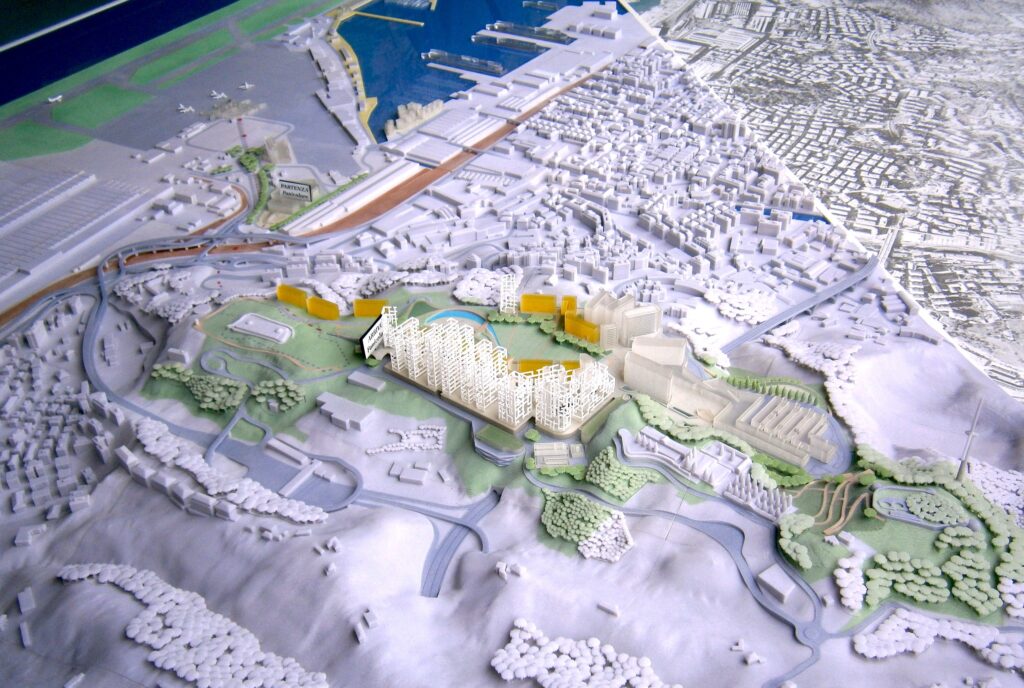
The Erzelli Science and Technology Park, physical model for public presentation. (Photo: Luca Salvetti, 2011).
The project has undergone several ups and downs over the years. Between 2008 and 2013, GHT invested around thirty million euros for the primary urbanization works, for the construction of the cogeneration plant, and for the construction of the first buildings. Ericsson, Siemens and the first companies and services settled in Erzelli from 2012. Esaote’s settlement dates back to 2015. In 2016, the project for the first section of the park was approved and new companies, such as IIT, Alten, Enega and Liguria Digitale, arrived on site.
The Science and Technology Park project is divided into several sections, the first measures implemented were hydrogeological redevelopment and the burying of power lines. In addition, two buildings were constructed (in Sub Sector 4) that currently house various services, including a gymnasium, a supermarket, a nursery school, and companies, including Siemens, Ericsson, Esaote, Liguria Digitale and IIT. With the construction of this first sector, the primary and secondary urbanization works (as provided for in the 2007 Convention) were also carried out, as well as various sub-services, including a public car park and the district heating plant.
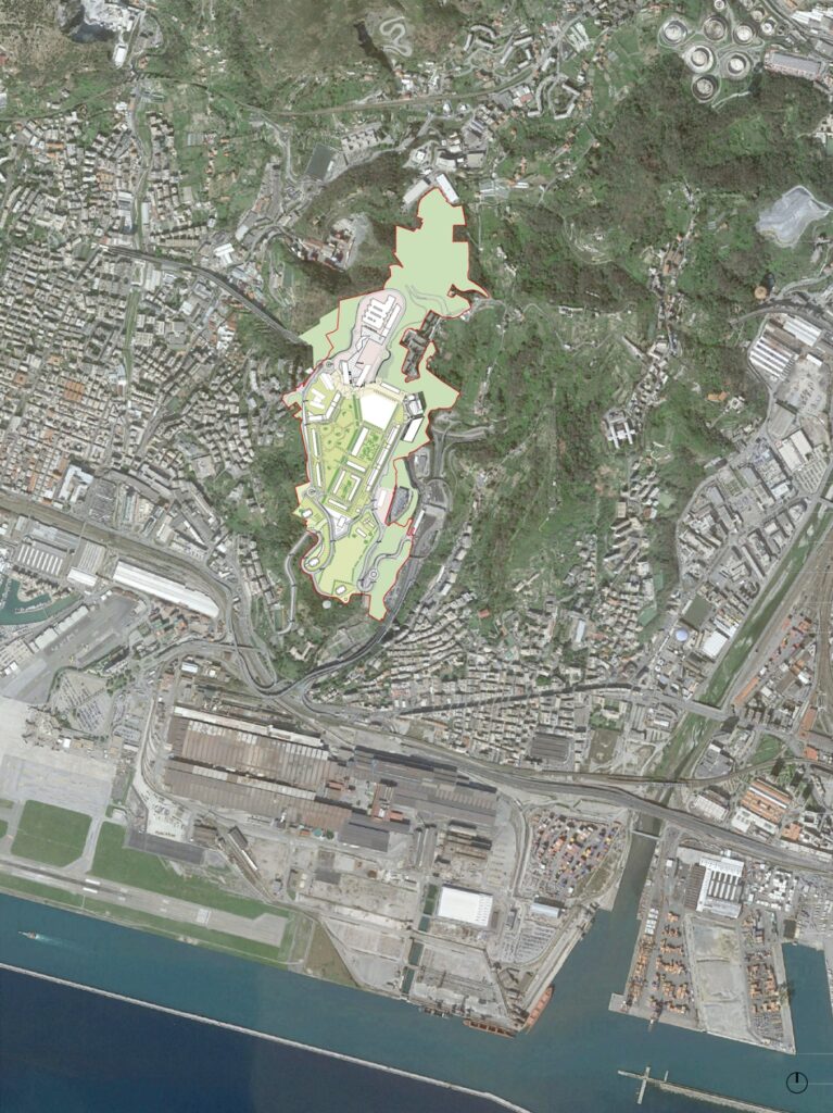
The Erzelli Science and Technology Park, orthophoto with volumetric view. SAU, 2019. (Source: Municipality of Genoa, Schema di Assetto Urbanistico 2019).
The position of the area undergoing transformation is particularly strategic from the point of view of connections due to its proximity to the railway system, the highway exit “Genova Aeroporto” and the airport node, located a short distance away. To improve connections with the rest of the territory, in implementation of the 2007 SAU, the road network for access to the park was extended. The current internal distribution within the Science and Technology Park is guaranteed by a temporary road system, pending the realization of the ring road system envisaged by the master plan. In fact, the project envisages mobility management on several levels, with cars and public transport on a lower level and pedestrians, bicycles and electric vehicles on the upper level. The project also envisages the construction of a monorail connecting the area with a new Erzelli-Aeroporto railway station.
The Erzelli Science and Technology Park, project plan. (Source: Municipality of Genoa, Schema di Assetto Urbanistico 2019).
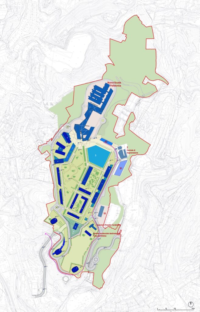
The green system included in the project covers over 329,000 sqm and is divided into three areas: the central diffuse green park (about 103,000 sqm), the Monte Guano Park (106,000 sqm) and the state-owned area around Forte Erzelli (23,000 sqm). A ridge path is also planned to be built alongside the Monte Guano Fortress and the Erzelli Fortress.
According to the Programme Agreement signed in July 2020, the main uses envisaged for the area are: training, high-tech production activities, executive activities, crafts and small industry, residential, hospitality, hospital and park. The Polytechnic School will extend over an area of 60,000 sqm; craft and small industry over 2,800 sqm; the area for residential use, increased with respect to the first master plan of 2004, is 105,450 sqm; the receptive function amounts to 4,000 sqm; the area to be used for the new service of the Ospedale del Ponente is 60,000 sqm, while the connective area is 8,050 sqm. In addition to these, there is a Carabinieri Barracks (1,000 sqm) and 2,000 sqm of residential area to support it; a total of 21,738 sqm of public parking spaces are also planned.
Digital Innovation Hub Liguria. New Epicenter of Urban and Port Development
The realization of the Erzelli Science and Technology Park, hypothesized as the port city’s new primary attraction pole, is particularly emblematic of current urban dynamics. In fact, the development of the project is closely linked to its strategic positioning with respect to the infrastructure system, due to its proximity to the railway system, the Genova Aeroporto highway junction and the airport node. The very possibility of completing the project is directly related to the ability to improve its accessibility through the construction of a multimodal connection, the financing of which will be public.
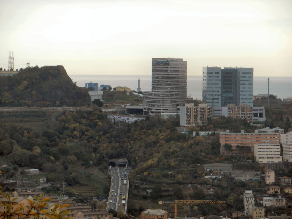
The Erzelli Science and Technology Park, first buildings completed. (Source: Wikimedia Commons, Creative Commons Attribution-Share Alike 3.0, 2014).
The realization of the new Ligurian high-tech pole originates within the complex scenario of the globalization of economies, which has led the competition between the different urban realities to be a discriminating element for their economic development (Scott, 2008), tending to transform and reinvent themselves through the emergence of new epicenters. Last but not least, the role played by the public actor in the entire operation is fundamental: the State participates in the operation through Amco, a company belonging to the Ministry of Finance that recovered the shares sold by Banca Carige; the Liguria Region played a decisive role, deciding to locate the new hospital of the Ponente in the area; the University of Genoa assumed a crucial position through the future transfer of the engineering school to the Erzelli pole.
At the same time, the new epicenter of urban development allows rethinking the vocation of the entire area with a fundamental shift to a production linked to new technologies and more sustainable approaches. The realization of the Erzelli project takes on a new strength, then, if considered in connection with the Green Factory project, planned in the Parco del Ponte, with a mix of uses between logistics, technology and craftsmanship 4.0 and, even more, in synergy with the recent Genoa Blue District, the cluster dedicated to the blue economy that integrates the sea industry, hi-tech, enterprise and tourism and acts as a driving force for the development of Genoa’s maritime and logistics chain.
HEAD IMAGE | The Erzelli Science and Technology Park, construction site for the new technology hub. (Source: Wikimedia Commons, Creative Commons Attribution-Share Alike 3.0, 2010).
╝
ACKNOWLEDGEMENTS
The article is the result of joint research between the three authors. For the purposes of scientific attribution, paragraph “City, port and productive districts: the territorial context of Genoa’s Ponente region” is by Giampiero Lombardini, paragraphs “The West of Genoa Between High-Tech, Infrastructure and Retro-Port Activities” and “Digital Innovation Hub Liguria. New Epicenter of Urban and Port Development” are by Beatrice Moretti, paragraph “The Erzelli Science and Technology Park. Design Process and Urban and Architectural Characters” is by Matilde Pitanti.
REFERENCES
Airaldi G., 2012, Breve storia di Genova, Pacini Editore, Pisa.
AA.VV., 1987, “Dossier Genova”, in Spazio e Società, n.37.
Balletti F., Lombardini G. (2018) (a cura di), “Ponte Morandi oltre la ricostruzione: strategie per la rigenerazione urbana,” in Urbanistica Informazioni, numeri 280-281, INU Edizioni, Roma.
Giontoni B., 2020, Le trasformazioni di Genova; Genova. Piani e interventi urbanistici dagli anni Settanta ad oggi, Erga.
Marchi P., 1979, Genova e le valli Bisagno e Polcevera, Sagep, Genova.
Moretti B. (2018), “Paesaggi logistici e infrastrutture osmotiche. Il caso della Val Polcevera a Genova”, in Urbanistica Informazioni, numeri 280-281, INU Edizioni, Roma, pp. 23-24.
Scott A., 2008, Città e regioni nel nuovo capitalismo. L’economia sociale delle metropoli, Bologna, Il Mulino.
REFERENCE LINKS
Airaldi G., 2012, Breve storia di Genova, Pacini Editore, Pisa.
Digital Innovation Hub Liguria. [Online]. http://www.dihliguria.it [Retrieved: April, 11th 2023].
Genova Blue District. [Online]. https://www.genovabluedistrict.com [Retrieved: April, 11th 2023].
Caputo Partnership International. (s.d.) Progetto Nuovo Masterplan Parco Scientifico Tecnologico “Erzelli Smart City”, Genova. The Plan. [Online]. https://www.theplan.it/award-2019-urbanplanning/progetto-nuovo-masterplan-parco-scientifico-tecnologico-erzelli-smart-city-genova-1 [Retrieved: June, 14th 2021].
Comune di Genova (2020) Relazione Tecnica. Promozione dell’Accordo di Programma per l’approvazione del nuovo Schema di Assetto Urbanistico del settore n.1 dell’Area di Intervento n.11 del distretto n.4 del Piano Territoriale di Coordinamento degli Insediamenti Produttivi dell’area centrale ligure – Parco Scientifico Tecnologico di Erzelli – Genova Sestri Ponente. http://www.comune.genova.it/sites/default/files/upload/2020_07_ERZELLI/relazione%20tecnica%2017.7.2020rev1.pdf [Retrieved: June, 14th 2021].
Great Campus PST. Genoa Research and Advanced Technologies http://www.great-campus.it/about-us/ [Retrieved: June, 14th 2021].
Piano Urbanistico Comunale Vigente. Assetto Urbanistico e Sistema dei Servizi Pubblici. Settore Erzelli. http://www.comune.genova.it/sites/default/files/upload/2020_07_ERZELLI/ELABORATI%20SAU_AGG_LUGLIO_2020/01_SAU%202019_Inquadramento%20urbanistico/0.1.SAU.GEN.000.PUR.URB.00.pdf [Retrieved: June, 14th 2021].
Primo Canale. Intervista a Renzo Piano: “Io fuori dal progetto Erzelli”. Pubblicato il 23 novembre 2006. https://www.primocanale.it/video/intervista-a-renzo-piano-io-fuori-dal-progetto-erzelli–11383.html [Retrieved: June, 17th 2021].
Regione Liguria, Comune di Genova, Università degli Studi di Genova, Genova High Tech S.p.A. (2020) Schema di Accordo di Programma la società per l’approvazione dello Schema di Assetto Urbanistico, Settore n. 1 dell’Area di Intervento n. 11 del Distretto n. 4 (Parco Scientifico Tecnologico di Erzelli). http://www.comune.genova.it/sites/default/files/upload/2020_07_ERZELLI/Schema%20Accordo%20di%20Programma.pdf [Retrieved: June, 17th 2021].
Schema di Assetto Urbanistico 2019. Planivolumetrico esemplificativo di massima su ortofoto. http://www.comune.genova.it/sites/default/files/upload/2020_07_ERZELLI/ELABORATI%20SAU_AGG_LUGLIO_2020/07_SAU%202019_Planivolumetrico/F.1.SAU.GEN.000.PUR.PEM.01.pdf [Retrieved: June, 25th 2021].
Schema di Assetto Urbanistico 2019. Planivolumetrico esemplificativo di massima e rendering progetto. http://www.comune.genova.it/sites/default/files/upload/2020_07_ERZELLI/ELABORATI%20SAU_AGG_LUGLIO_2020/07_SAU%202019_Planivolumetrico/F.7.SAU.GEN.000.PUR.PEM.00.pdf [Retrieved: June, 25th 2021].
Schema di Assetto Urbanistico 2019. Planimetria generale. Zonizzazione delle funzioni. http://www.comune.genova.it/sites/default/files/upload/2020_07_ERZELLI/ELABORATI%20SAU_AGG_LUGLIO_2020/05_SAU%202019_Zonizzazione%20delle%20funzioni/D.1.SAU.GEN.000.PUR.ZDF.01.pdf [Retrieved: June, 25th 2021].
Schema di Assetto Urbanistico 2019. Tavola di confronto Perimetro Sau 2007 – Sau 2019. http://www.comune.genova.it/sites/default/files/upload/2020_07_ERZELLI/ELABORATI%20SAU_AGG_LUGLIO_2020/01_SAU%202019_Inquadramento%20urbanistico/0.3.SAU.GEN.000.PUR.URB.00.pdf [Retrieved: June, 25th 2021].
Schema di Assetto Urbanistico 2019. Tabella delle densità edilizie articolate per funzioni e sub-settori. http://www.comune.genova.it/sites/default/files/upload/2020_07_ERZELLI/ELABORATI%20SAU_AGG_LUGLIO_2020/08_SAU%202019_Relazione%20tecnica/R.1.SAU.GEN.000.PUR.GEN.02.pdf [Retrieved: June, 25th 2021].
Schema di Assetto Urbanistico 2019. Verifica di assoggettabilità alla V.A.S. Rapporto preliminare. http://www.comune.genova.it/sites/default/files/upload/2020_07_ERZELLI/ELABORATI%20SAU_AGG_LUGLIO_2020/12_SAU%202019_Verifica%20VAS/01.A0_SAU.GEN.000.%20VAS_RAPPORTO%20PRELIMINARE.pdf [Retrieved: June, 25th 2021].
Urban Center (2008) Il Parco Scientifico Tecnologico. [Online]. http://www.urbancenter.comune.genova.it/node/238 [Retrieved: July, 8th 2021].