The relation between ports and cities has been studied from so many perspectives and going through a lot of phases i.e., discovery, interdependency, and spatial and strategic separation, this was due to the fact that the role of the ports was always in a constant evolution (Pigna, 2014). That is the case especially when talking about historical port-cities where the traces of this evolving relationship is visible in the urban fabric of the cities and the spaces shared with the ports. In this case the preservation and reuse of port heritage pays an important role as the warranty to keep the memories of this territorial binomial.
Port Said stands out as a case of a city planned to be a port-city. The relatively short age of the city of Port Said, when compared with other existent ones in its hinterland, helped to consider the existence of only one port. Also, the fact of being a city previously planned contributed to the successful development and unnecessary dislocation of the port activities to wider spaces. Unlike the case of Alexandria, as a local example, where the historical port is not in the same area of the port running right now. Similar options were developed in some Tombolo cities in the region, like Tyre in southern Lebanon, with two ports in addition to the city of Izola in Slovenia (Hastaoglou-Martinidis, 2010). This article presents a general overview of the port-city heritage statement in the city of Port Said and its potentials.
Port Said context
Port Said is one of the main ports of Egypt, it comes after Alexandria port which is considered to be main port of the country dating back to 1900 BC. The city is located on the Mediterranean cost on the northern entrance of the Suez Canal, also known as the Suez Canal terminal; it is a transhipment port for transit traffic in the Mediterranean region, and one of the largest container hub ports in the region (Ades, 2017).
Egypt is the only land connection between the two continents, Africa and Asia, where the country has direct access to Red Sea and the Mediterranean, as the two seas separating the lands. This important strategic position has led to the emerging of several ports and cities along the two coasts.
Alongside 2000 kilometers of shorelines, the country has developed a port system based on historic ports and the new circumstances basically provoked by Suez Canal aperture.
Therefore the system is consisting of several ports on the two coastlines of the Mediterranean and Red Sea. Starting from the west coast of the Mediterranean, the main ports exist on the following cities, Marsa Matrouh, Alexandria, Damietta, Port Said, Suez and Safaga (Elnabawy, 2015).
Port Said and its port were constructed together with Suez Canal digging in 1869. It is located at the northern entrance of Suez Canal, facing the Mediterranean sea. Vessels up to 12.8mtr draft can pass through the port entrance. Furthermore, due to its unique location, Port Said is a main transit port of call with around 470 passenger ship calls a year [1].
When talking about Port Said, it is important to identify the ports system where this city belongs to, and what is making it different from the other port cities of the system, and it is fundamental to define the right context where this system must be inserted.
Some ports took advantage form emerging opportunities of developing around Mediterranean basin. Other continental ports have lost old industrial functions. Damietta, Alexandria and Port Said have assumed transhipment roles as important nodes in the Eastern Mediterranean area, due to their favorable locations (Hastaoglou-Martinidis, 2010).
The strategic location of the country explains that 90% of the Egyptian Foreign Trade is managed by all the ports. In any case these numbers are always hiding the special statement of Alexandria port, which supports 65% of the trading national movements [2].
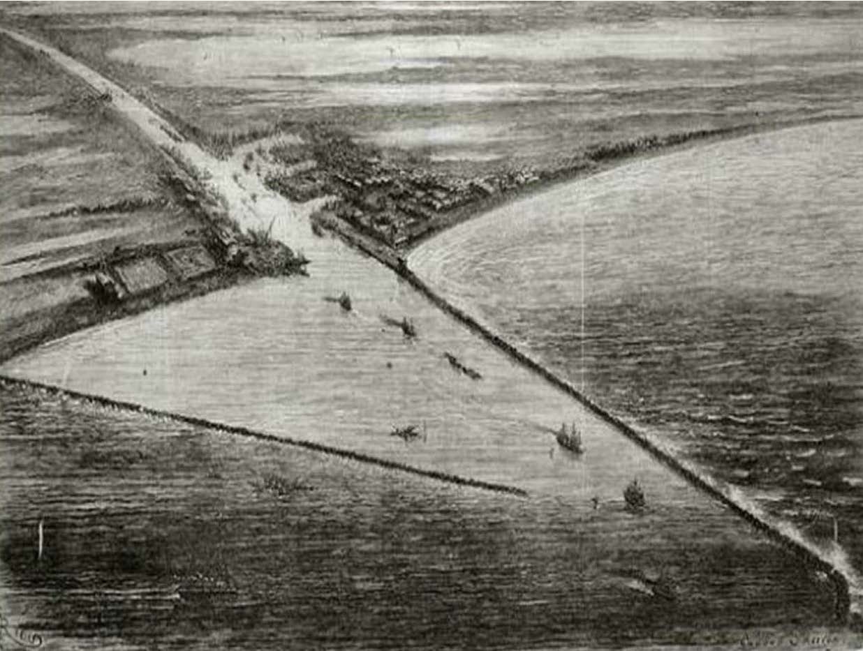
The figure above shows a sketched vision for the city of Port Said in the 1870’s, the outline of the western bank seems to be almost as it is today, which reflects the idea of a city planned from the beginning as port-city, and how this can be beneficial for the port and city relationship which will be discussed later, and when did the mistakes happen if the city seemed to be planned step by step always hosting the port.
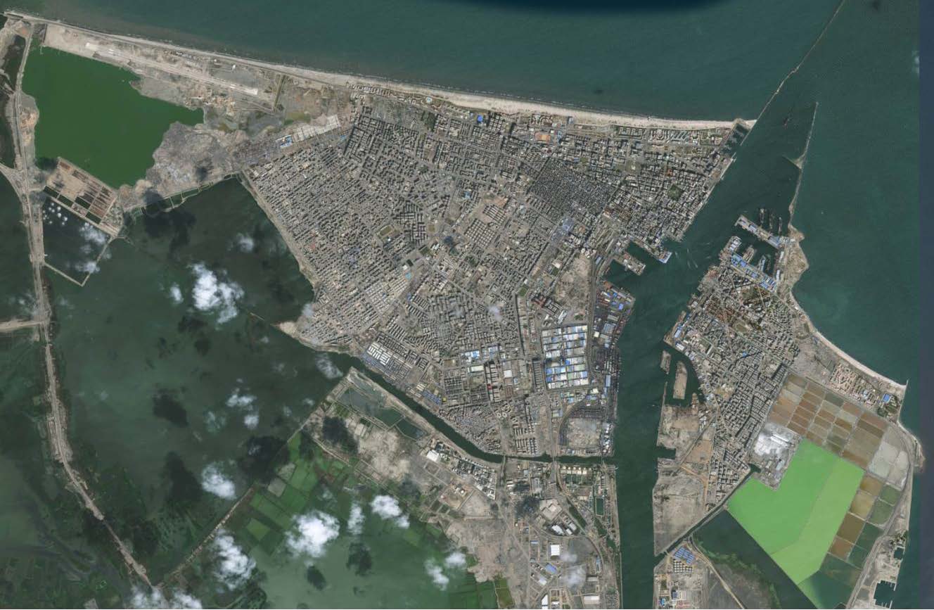
Port Said is a twin city, including Port Said (on the west bank) and Port Fouad (on the east bank) with the original Suez Canal passing in between. This canal is an artificial sea level waterway connecting the Mediterranean Sea and the Red Sea.
The port area is three km2 with a warehouse area of 90,000 m2 and container yard area of 435,000 m2.
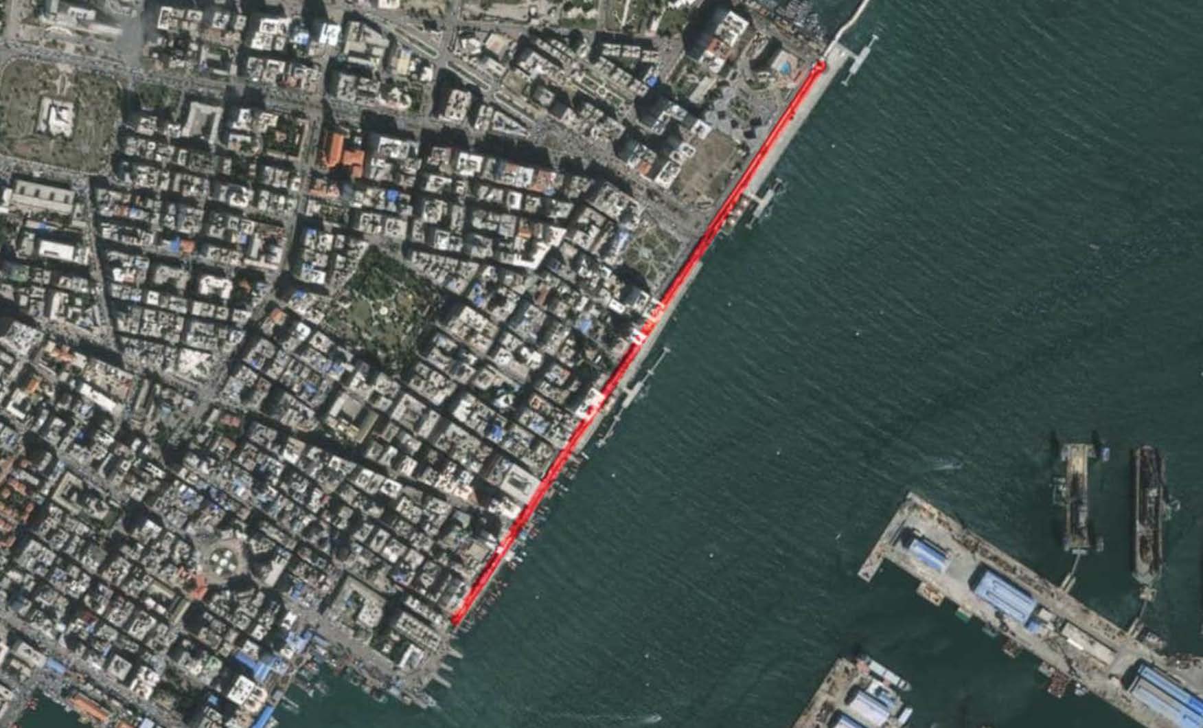
Around the port, there are some areas that could be identified as buffer-zones could be seen in the aerial picture, these zones are outside the Port Authority domains and not controlled by the Port Authority but the existence of this subsidiary industrial zones of the port is depending on the existence of the port and the question is what will happen to these areas if some of the port activity changed overtime.
The restricted accessibility to the port area is more evident in this case due to the severe security measures over this national strategic installation, which is a point to raise about the difference of security criteria dealing with in all the eastern Mediterranean ports when compared with the Northern European ports.
Port Said urban process can be summarized and analyzed in five main milestones (Ades, 2017):
1. The establishment of the city with opening of Suez Canal between 1859 and 1876 and the appearance of a first urban form. It is the period where there are no signals of physical separation between the port and the city.
2. The city starts the spatial appropriation process in a gradual landfilling process. This process started alongside the Mediterranean façade, achieving the current statement in 1867. The water line of Manzaleh Lake, located on the western side of Port Said, was only altered because of needs to implement the railway infrastructure arriving till the central urban fabric without important modification in the port shoreline. Therefore the railway between Port Said and Cairo was set in motion in 1904.
3. Only after 1888 this Manzaleh Lake on the west will assume an important role in the coming steps of the relationship between the port and the city. An important transformation of the lake let insert two main southern water lines, landfilling the surroundings of the urban fabric and including new services for the city, as per a map published in 1937 [3]. It was the time where the relationship between the port and the city was more expanded and not only limited to the canal shoreline. This scenario gave Port Said the chance to relish an important ratio between green spaces or urban voids and built up ones leading to a vast sport areas were inserted as links in the area separating the port and the city.
4. However this process was disrupted when two main decisions changed drastically the scenario. First, a more developed railways infrastructure was implemented leading to the removal of the golf courts to propose an urban fabric acting as tongues in between the port areas. It was a provisional statement before disappearing the waterlines in the west southern urban area. The urban voids, initially considered as spaces for the citizenship, were transformed into closed railways structures, as the main protagonist between the port and the city.
5. Finally, the master plan of 1956 [4], thought as the opportunity to reconstruct the city after being destroyed by the attacks in 1956, confirms several topics: the city was in need to accommodate its structure to be more competitive within a scenario dominated by the industrial wave proposed by Egyptian President Nasser. Furthermore, urban needs to improve the quality of life would be in a secondary level in terms of priorities. Even that, the master plan in 1966 proposed to include a large area as a green area, as the intention of refocusing the city on such hot spots. This master plan was aborted by the Egyptian – Israeli conflict in 1967.
Heritage
Consequently it can be concluded that like every other port-city, the relation between Port Said and its port has been going back and forth as mentioned earlier, and the depending relation tied between the port area and the supplementary industrial areas around it is quite obvious (Ades, 2017). Therefore some potential urban void areas can arise slowly with the removal of most of the port activities, as an expected future scenario, to the new eastern port, beyond Port Fouad. Nowadays, these areas act as a sort of barriers and insulating the city from the port. The continuous crises in the eastern Mediterranean region and its character of conflict territory contributed to achieve this statement.
This hypothetical scenario, that is most likely going to happen, raises an important question about the future of these urban voids and the port heritage in the area.
In this case, a definition of what is heritage in such context is needed, and which are the heritage topics related to the port-cities relationships in the Eastern Mediterranean region. This is to be addressed in two scales, one is the value of this port in the eastern Mediterranean region and the local value of the port in the city itself. Therefore heritage values in Port Said are really important, and there are two sides to be considered, heritage and Port Authority area and the second is the heritage and city domain, especially alongside the canal facades, especially in a city born because of the canal and the harbor.
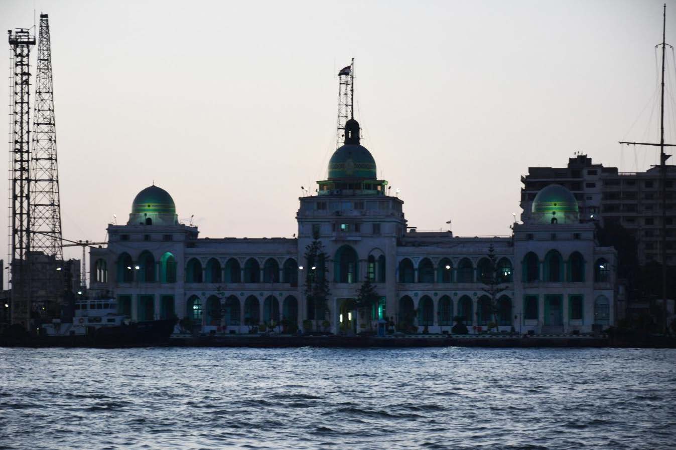
The first point can be addressed with the consideration of Suez Canal as a block where the two ‘cities’ and territories of the whole canal are one object to be considered as heritage, highlighting the strong relation between the colonial architecture of the waterfront in Port Said and the port as an inseparable urban layout. As a city being born because the canal and the harbor, where port authorities have an excellent opportunity to lead the regeneration of the canal as a reference for the region joining again the port and the city.
Moving to the second point, two historical jewels alongside the canal be detected. In this case, there are some elements playing the role of landmarks in the city of Port Said, except the entire functionality of the Port Authority buildings. The first is the Suez Canal historical authority building which has an architectural value from the colonial period. The historical building is part of the identity of this city, a symbol of shared heritage between the city, its port and the Suez canal, with the three projects coming together to life at the same time. the building can play a big role telling the story of this area and how it came into being. It could be given a new cultural function, including an exhibition about the history of the three merged realities, nevertheless keeping part of its administrative role.
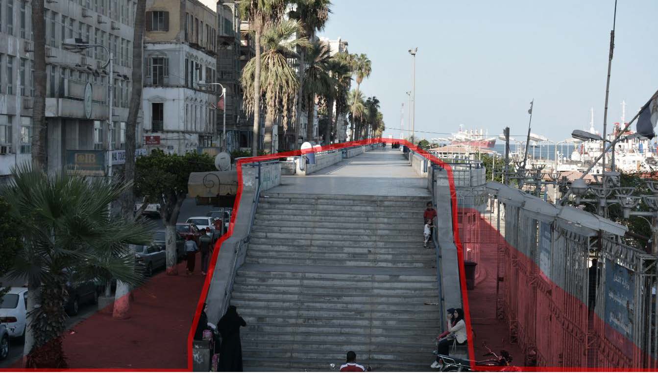
The second is an elevated pedestrian promenade alongside the canal which can be related to the ‘port-city’ urban characteristics of the region, Luckily it is still existing and they did not destroy it for the sake of the port unlike other cities, which reflects the similar treatments of the areas between the port and the city during the 19th century. The most known reference would be ‘Terrazo di Marmo’ in Genoa, It was first destroyed to ‘improve’ the efficiency of the port railways [5].
Since the displacement of most of the port activities towards the east is most likely to happen, Port Said shows great potentials to utilize such elements in order to recover such heritages. Port authorities have an excellent opportunity to lead the regeneration of the canal as a reference for the region joining again the port and the city.
Notes
[1] According to the Association of Meditarrenean Cruise Ports 2016/2017.
[2] Harris, Frederic R., (1979), Master Planning and Infrastructure Development for the Port of Damietta, on page 10.
[3] Historic map of Port Said in 1936 (Source: Naval-History.net).
[4] Historic map of Port Said in 1956 (Source: Naval-History.net).
[5] “La Sopraelevata di Marmo – Storia di Genova”, ilmugugnogenovese.it, Last modified February 15th 2017, https://www.ilmugugnogenovese.it/la-sopraelevata-di-marmo-genova/
References
Ades, A (2017), Urban voids and resilience in Egyptian port-cities (Master’s thesis), German University in Cairo, Cairo, Egypt.
Elnabawy, M. N., & Hassan, M. H. (2015). The competitiveness of port said port transshipment of container trade vis-àvis Mediterranean region and the world. International Journal of Research in Engineering & Technology.
Ducruet César,(2011) The port city in multidisciplinary analysis, Alemany Joan and Bruttomesso Rinio, The port city in the XXIst century: New challenges in the relationship between port and city, RETE, pp. 32-48.
Hastaoglou-Martinidis, Vilma (2010) Cartography of harbor construction in Easter Mediterranean cities.
Hastaoglou-Martinidis, V. (2011) Urban aesthetics and national identity: the refashioning of Eastern Mediterranean cities between 1900 and 1940, Planning Perspectives, 26 (2), 153-182.
Mobarak, I. (2007, February). Egyptian Port Development and Efficiency Enhancement. In Proceedings of the 23 rd International Port Conference Port Technology: Port Training Institute. AASMT.
O’Mahony, H. U. G. H. (1993). Egyptian port ambitions converge. Cargoware international.
Pigna, Franc J, ‘Port Authority Corporatization: leading towards their privatization?’ Port Infrastructure Finance, edited by Meersman, H. Van der Voorde, E., Vanelslander, T., (London: Informa law from Routeledge, 2014), pp, 69-86.
Pigna F. J (2014) The City-Port Relationship: its evolution, changing dynamics and challenges for port authorities, , in Port City Governance,4th Chapter. Ed. Ems.
Head Image: Port Said. (Source: Google Earth)