A simple plan for a complicated problem
When the idea for a new waterway from the North Sea to Rotterdam was devised, the port city had already been hard to access for over 100 years. Because the river Maas – a distributary of the Rhine in the delta of South Holland – was silting up, ships were forced to take detours to enter and exit the port. For the largest ships, this detour was as long as 115 kilometers, leading all the way through the Oosterschelde sea arm in the province of Zeeland. In 1853, a state committee asked the young engineer Pieter Caland to study how local authorities in the UK and France were keeping the river mouths of the Clyde (Scotland), Seine and Rhône (France) deep enough for shipping traffic.

Born and raised in Zierikzee in Zeeland, Caland was the son of the head engineer of the provincial water authority. He studied at the Dutch military academy to become a cadet for the Waterstaat (the national water authority), which provided him an engineering education [1]. Caland worked at several posts throughout The Netherlands and settled in Brielle, which was close to both the port of Rotterdam and his native Zierikzee.
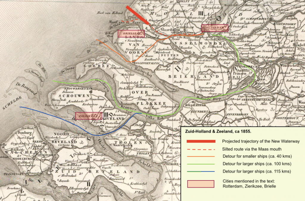
His position in Brielle and his knowledge of local water works made Caland suitable for the research into a solution for a faster waterway to and from the port of Rotterdam [2]. The report he wrote, however, was put aside and Caland was asked to be the secretary for the Raad van Waterstaat, a committee installed to come up with a final decision about the plans that had been made so far. To the surprise of the committee, Caland presented his own plan: a deceptively simple design that cut through the Hook of Holland (from the Dutch Hoek, meaning corneror angle) and that would reduce the distance between the port of Rotterdam and the North Sea to 30 kilometers. According to Caland’s calculations, the fluctuation of the tides would keep this new waterway open and at a berth that was deep enough for the newest steam vessels.
The national character of the plan meant that it had to be confirmed by the two chambers of Parliament. At first, the plan for Caland’s New Waterway was criticized as being too expensive and unfairly beneficial toward Rotterdam, leaving the nation’s capital of Amsterdam behind. Once the law included a counterpart to the Waterway – the Noordzeekanaal (North Sea channel) from the North Sea to Amsterdam – it stood a chance of passing. In a dramatic plea before the Senate, the liberal minister of internal affairs Johan Rudolf Thorbecke tried to balance the risks of starting two major national water works against the economic benefits and their importance for the nation: “I say again that it is a daring work, but a work that we must venture. It is what one does, when one embarks on an unequal struggle for one’s freedom and independence. If we stay what we are now, we will be passed by and decay; it therefore seems to me an unavoidable duty to seize the resources that may save us” [3].
In January 1863, the law for two waterways was promulgated. Members of the local business elite, however, still worried that the Waterway would become too expensive: while the State would pay for the construction, the municipality of Rotterdam would have to bear the costs for any overrun or maintenance. Still, most local businesses figured they could benefit from this national feat. The Waterway was Rotterdam’s last hope to latch on to the development of steam shipping, especially since the Royal Netherlands Steamship Company had chosen to settle in Amsterdam instead of Rotterdam in 1856.
Construction and criticism
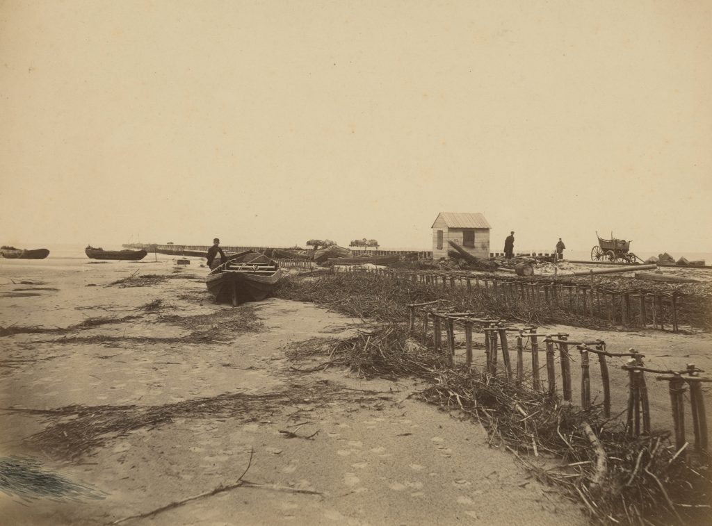
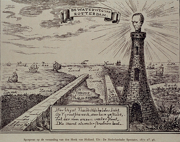
On October 31st, 1866, the heir apparent dug the first spade in a ceremony in the presence of Caland, by then the director-engineer overseeing the project. This ceremony was, however, not the end of the controversy. During the years of digging, the Waterway remained a topic of discussion between believers and non-believers in Caland’s tidal plan. Rotterdam seemed to reap the benefits, for example, with a steam liner company that was established in 1871 by the merchants Otto Reuchlin and Antoine Plate. Meanwhile, newspapers reported widely on all the setbacks. Even after the first ships had passed the Waterway in 1872, Caland’s design was criticized. A satirical cartoon showed prime minister Thorbecke overlooking the Waterway, which had almost entirely been overtaken by sand.
The criticism was not baseless. While Caland’s idea of the tides maintaining the Waterway’s berth worked for the most part, they were not strong enough to preserve the fairway at sea. Critics suggested it was high time to add sluices to the Waterway, a solution that opposed Rotterdam’s ambition to remain a free and open port. The committee that was appointed to find a solution did not include Caland, who consequently withdrew from the whole project. Caland did reach the position of head inspector of the national water authority, but not finishing his brainchild was a bitter ending to his work. His father brought some consolation when he wrote to him that all great men had to suffer some degree of “offense, misjudgment, and sometimes vilification”, but afterwards were praised, and even had “statues erected for them” [4].
Commemorating Caland
His father turned out to be right. Improving dredging techniques made it easier, quicker and cheaper to remove sand banks and deepen the berth, so the growing steam ships had the quick access to the port of Rotterdam that Caland envisioned in 1858. In 1902, the year of his death, 6755 ships entered Rotterdam via the Waterway – almost triple the number of ships that entered in 1866. He was not praised for these successes during his lifetime, however. Only in 1906 did mayor Frederik Bernard S’Jacob of Rotterdam use the money he received for his retirement to erect a monument for Caland. It was the start of a process in which the Waterway slowly became appropriated as an icon of Rotterdam’s efflorescence.
During the Great Depression of the 1930s, the Stichting Havenbelangen (association for port interests) used the 1936 anniversary of the Waterway to look back on the vigor and courage that Caland, Thorbecke and the Rotterdam elite had shown in the 1860s. In a speech, the president of the Chamber of Commerce W.A. Engelbrecht interpreted the meaning of the New Waterway as a “…strengthening of civic power and confidence in times of adversity, moreover, an ever more deeply rooted awareness of the tight bond of our port city with our country in its global relations [5]”. His speech illustrated how Rotterdam saw the Waterway as a result of local civic power that was crucial for the Dutch economy, and therefore needed renewed attention and investment from the national government [6].
After the Second World War, in which both the port and city of Rotterdam suffered heavy losses, the economic significance of the New Waterway again appeared in cultural representations. In 1941, a children’s play about the Waterway reminded the audience of Rotterdam’s resilience and innovativeness, while a 1947 stadium spectacle was named De Waterweg Heroverd: the Waterway reconquered [7]. In 1952, the former minister of Reconstruction J.A. Ringers wrote a small book on Caland and the meaning of the Waterway of Rotterdam. Yet again, he drew the comparison between an urban spirit of reconstruction which nevertheless required national investment in order to safeguard the “blessed effects” for Rotterdam and the whole of the Netherlands [8].
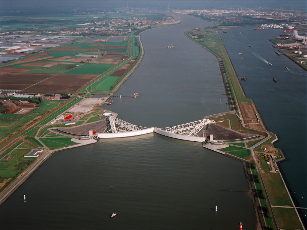
In 1966, Rotterdam became the busiest port in the world, a position it held until 2006. Meanwhile, the Waterway still needed dredging every once in a while. This had become easier due to new dredging techniques, but with the rapidly growing petrochemical industry and the introduction of the container in the 1960s the demands for the depth of the Waterway increased as well. In 1979, Alderman Jan Riezenkamp argued with the Dutch state to invest in its “artery” and bring it to a depth of 75 feet [9]. A huge investment of the State was once again necessary when the New Waterway had to be adapted for storms and spring tides, as a capstone for the Delta works that were initiated after the devastating flood in 1953. The flood barrier “Maeslantkering” opened in 1997 and consists of two large “arms” that allow the Waterway to remain open when there is no threat. It cost approximately 1 billion guilders [10].
A new way?
In March 2022, it will be 150 years since the first sea steamer crossed the New Waterway. The municipality will again celebrate this anniversary, but more than ever the question arises whether the Waterway is indeed still the artery of the Netherlands. While the port of Rotterdam remains the busiest in Europe, the port city is lagging behind with its counterparts in Hamburg and Antwerp when it comes to maritime services [11].
More than the ability to host ever larger ships, the success of a port city is measured by the amount of headquarters, the quality of life, and the “smartness” of a port: the ability to connect to digital rather than physical flows. At the same time, the port city region of Rotterdam needs to adapt to the threat of rising sea levels. In order to tackle this multifaceted problem, it is not enough to dredge an even deeper fairway, as an angioplasty to unblock the “artery of the Netherlands”.
Rotterdam needs the innovation and vigor that over 150 years ago led to the simple but brilliant design and the collaboration on several governance levels to execute it.
Head Image | Diorama Nieuwe Waterweg: overview waterway area with the port of Rotterdam. Wall painting made by Jaap Gidding for the World Expo in 1930. (Source: Collection Museum Rotterdam, 78609, CC BY-SA 3.0 NL).
References
“Access Channel to Europoort Will Be Deepened – and Fairly Soon Too”. Barid Hollanda, 1979. VI F 93. Stadsarchief Rotterdam.
Bruin, M.P. de. “Pieter Caland.” In Encyclopedie van Zeeland. Accessed October 11, 2021. https://encyclopedievanzeeland.nl/Pieter_Caland.
Houter, den, F. Rotterdam En de Nieuwe Waterweg. Schip en Haven 3. Amsterdam: C. de Boer jr., 1956.
Ringers, J.A. Caland En de Betekenis van Zijn Werk Voor Rotterdam. Rotterdam in Verleden En Heden 10. Rotterdam: Ad. Donker, 1953.
Sennema, Hilde, and Paul Van De Laar. “Rotterdam’s New Waterway: The Iconification of an Infrastructure (1860-1947)”. European Journal of Creative Practices in Cities and Landscapes Vol. 4 No. 1 (August 2, 2021): 77-94. https://doi.org/10.6092/ISSN.2612-0496/12389.
Thorbecke, Johan Rudolph. Parlementaire Redevoeringen. Vol. 2. Deventer: A. ter Gunne, 1867.
Verhetsel, Ann, and Steve Sel. “World Maritime Cities: From Which Cities Do Container Shipping Companies Make Decisions?” Transport Policy 16, no. 5 (September 2009): 240–50. https://doi.org/10.1016/j.tranpol.2009.08.002.