╔
La rinascita del rapporto tra Palermo e il suo waterfront: una storia urbanistica lunga vent’anni
Dovendo raccontare una lunga storia, usiamo un artificio narrativo e cominciamo dalla fine. O meglio, da quella che sappiamo essere la più recente e importante tappa di un percorso ancora in evoluzione, soprattutto che produrrà effetti non prevedibili perché generati dai suoi stessi esiti tecnici quando si miscelano con la comunità di chi li usa.
È un afoso pomeriggio di prima estate a Palermo e abbiamo voglia di vedere il mare. Per anni, gli ospiti di convegni, gli amici in vacanza e i visitatori di passaggio hanno espresso lo stesso desiderio e ripetuto la frase: «Siamo venuti tante volte a Palermo, ma non abbiamo mai visto il mare». Un’affermazione che può sembrare paradossale per una città nata dal mare e sul mare. Eppure, per molto tempo, a Palermo non è stato così facile trovare l’occasione, il luogo e persino il modo di incontrarlo davvero. A meno di non dirigersi verso Mondello o in una delle borgate marinare, attratti da una passeggiata sul lungomare o da un pranzo a base di pesce, il mare rimaneva distante. Il porto – quello dei cantieri navali, dei traghetti, delle infrastrutture per il trasporto delle merci e dei passeggeri – si presentava come una grande macchina funzionale, separata dalla città, opaca nelle sue logiche e poco accessibile ai cittadini.
Oggi, invece, in questo torrido pomeriggio estivo, siamo nel centro della città e davanti al mare a cercare refrigerio, ma anche bellezza e benessere, a esaudire il desiderio di spazio pubblico e ad alimentare la meraviglia.
Alle nostre spalle si staglia il Castello a Mare, riaffiorato dopo decenni di oblio. Le sue tracce, a lungo sommerse sotto una spessa coltre di cemento, sono state restituite alla città dopo che la costruzione del cosiddetto Molo Trapezoidale ne aveva quasi cancellato la memoria, nascondendo le bellissime vestigia della storia per accogliere orridi capannoni, depositi e serbatoi. Dove prima c’era un’infrastruttura reclusa e poco accessibile, dedicata solo ai traffici marittimi, oggi si apre uno spazio pubblico complesso attraversato da persone, sguardi e nuove forme di vita urbana.
Da urbanisti abbiamo avuto il privilegio di assistere a un evento raro: vedere realizzati alcuni tasselli di un’idea nata vent’anni fa e di un piano urbanistico redatto nel 2008. Poter passeggiare dentro un’idea, elaborata molti anni prima, tradotta in spazi concreti, in paesaggi ritrovati, in usi reali per accogliere la vita quotidiana delle persone, è uno dei rari privilegi che la disciplina urbanistica talvolta concede ai suoi autori.
Perché i piani hanno tempi lunghi, sono carsici – e talvolta non riaffiorano mai – attraversano stagioni politiche diverse, incontrano ostacoli, rallentamenti, cambi di priorità. Talvolta rimangono desolati relitti sulla carta, altre volte vengono traditi. Più raramente riescono a trasformarsi in luoghi reali capaci di produrre quotidianità.
Quella che oggi osserviamo affacciandoci sull’acqua è dunque la materializzazione di una visione costruita nel tempo, il risultato di un lungo processo di ideazione e pianificazione, di progettazione di dettaglio e di realizzazione incrementale, di dibattiti e conflitti – talvolta aspri – e di fruttuose alleanze istituzionali.
Attraverso la ricostruzione documentale di questo processo ventennale – piani, accordi istituzionali, atti di concorso, progetti concreti – questo contributo intende rispondere a una domanda che eccede il singolo caso palermitano: in che modo una visione urbanistica riesce a sopravvivere a discontinuità politico-istituzionali, cambi di amministrazione e conflitti tra enti, traducendosi infine in trasformazione fisica? Come si vedrà, il caso di Palermo suggerisce un percorso alternativo rispetto ai modelli di rigenerazione portuale maggiormente descritti in letteratura, fondati sulla progressiva sostituzione delle funzioni portuali tradizionali con usi turistici, ricreativi e immobiliari.
As this article recounts a long and complex story, it adopts a narrative device by beginning at the end – or, more precisely, from what currently represents the latest and most significant milestone in an ongoing process. It is a process whose future outcomes remain inherently unpredictable, as they will emerge from the interaction between the technical achievements of the project and the communities that inhabit and appropriate them.
It is a sweltering early summer afternoon in Palermo, and we feel the urge to see the sea. For many years, conference guests, friends visiting on holiday and occasional visitors would express exactly the same wish, often remarking: “We have been to Palermo many times, but we have never actually seen the sea”. At first sight, this may sound paradoxical for a city that was founded by the sea and has always owed its existence to it. Yet, for a long time, encountering the sea in Palermo was far from straightforward. Unless one travelled to Mondello or to one of the historic fishing villages for a promenade along the waterfront or a seafood lunch, the sea remained curiously distant. The port – with its shipyards, ferries and freight and passenger infrastructures – functioned as a vast logistical machine, physically and symbolically detached from the city, opaque in its operations and largely inaccessible to its inhabitants.
Today, however, on this scorching summer afternoon, we find ourselves in the heart of the city, standing by the sea in search not only of relief from the heat but also of beauty, wellbeing and public space – seeking the sense of wonder that urban places are sometimes able to inspire.
Behind us rises the Castello a Mare, brought back to light after decades of neglect. For many years, its remains had lain buried beneath a thick layer of concrete after the construction of the so-called Molo Trapezoidale had all but erased its memory, replacing remarkable archaeological traces with warehouses, sheds and fuel tanks. What was once an enclosed and inaccessible port infrastructure devoted exclusively to maritime operations has now become a complex public space animated by people, encounters, new perspectives and emerging forms of urban life.
As urban planners, we have had the rare privilege of witnessing an unusual event: seeing parts of an idea conceived twenty years ago – and incorporated into a master plan prepared in 2008 – finally materialise. To walk through an idea imagined many years earlier, translated into tangible spaces, rediscovered landscapes and places that have become part of everyday urban life, is one of the rare rewards that the discipline of planning occasionally grants its practitioners.
Urban plans unfold over long time horizons. They often follow subterranean trajectories, sometimes never resurfacing at all. They pass through different political administrations, encounter institutional obstacles, delays and shifting priorities. At times they remain little more than abandoned documents; at others they are distorted beyond recognition. Only rarely do they succeed in becoming real places capable of sustaining everyday life.
The landscape that unfolds before us today is therefore the materialisation of a vision patiently constructed over time. It is the outcome of a lengthy process of strategic thinking, spatial planning, detailed design and incremental implementation, shaped by debates and sometimes intense conflicts, but also by productive institutional alliances.
By reconstructing this twenty-year process through plans, institutional agreements, competition documents and implemented projects, this article addresses a question that extends well beyond the Palermo case itself: how can an urban vision survive political and institutional discontinuities, changes in government and conflicts between public authorities, eventually translating into physical transformation? As the article will demonstrate, the Palermo experience suggests an alternative trajectory to the waterfront regeneration models most frequently described in the literature, which typically rely on the progressive replacement of traditional port functions with tourism, leisure and real estate development.
Una lunga storia urbanistica (e forse eroica)
A Long Urban Planning Story (and Perhaps a Heroic One)
In realtà, questa storia comincia molto prima. Inizia oltre vent’anni fa, quando Palermo iniziò a interrogarsi sul proprio rapporto con il mare e sul destino di un waterfront che, da margine infrastrutturale, avrebbe potuto tornare a essere uno dei principali spazi pubblici della città. Un porto che da limite invalicabile e macchina funzionale confusa e ostile potesse alimentare un nuovo slancio economico della città e della regione.
Quello che oggi appare naturale – passeggiare sul waterfront, affacciarsi sul Castello a Mare, prendere un caffè, ascoltare un concerto e attraversare spazi che sembrano essere sempre appartenuti alla città – è in realtà il risultato di un lungo processo di immaginazione e di progetto.
All’inizio degli anni Duemila Palermo cominciò a interrogarsi sul proprio rapporto con il mare. Non si trattava soltanto di ripensare il porto come infrastruttura, ma di ridefinire il confine stesso della città. Per decenni quel confine era stato una barriera: il porto funzionava, ma dialogava poco con Palermo; il mare era vicino, eppure distante.
Il primo segnale di un cambiamento arrivò con il recupero del Foro Italico, la grande area prodotta dalle macerie della Seconda Guerra Mondiale che aveva avanzato la linea di costa davanti alle mura civiche. Dopo aver eliminato le orride strutture che ne predavano la bellezza ed essere riusciti a far attecchire un prato resistente, il progetto di Italo Rota, delicato e potente allo stesso tempo, trasformò un vuoto urbano, figlio di macerie e di abbandono, in un grande spazio pubblico affacciato sull’acqua. Quel bellissimo e policromo “Mare Verde” mostrò per la prima volta che il waterfront poteva tornare a essere un luogo della città e non soltanto un’area di scarto dell’infrastruttura portuale a cui tecnicamente e giuridicamente l’area appartiene.
Pochi anni dopo prese forma una riflessione più ampia. Nel 2006 nacque l’Officina del Porto, un laboratorio di idee promosso dall’allora Autorità Portuale presieduta da Antonio Bevilacqua, nel quale progettisti, studiosi e giovani professionisti iniziarono a costruire una visione diversa del rapporto tra Palermo e il suo fronte marittimo. Da quella esperienza scaturirono le prime elaborazioni progettuali, presentate alla Biennale di Architettura di Venezia nel primo padiglione off realizzato a Palermo con la mostra internazionale “Città-Porto” (Bruttomesso, a cura di, 2006), e successivamente grazie anche alla spinta culturale di quella grande mostra, il nuovo Piano Regolatore Portuale (PRP) presentato nel 2008 [1] (Carta, 2025) (vedere l’immagine seguente).
In reality, this story begins much earlier. It started more than twenty years ago, when Palermo first began to question its relationship with the sea and the future of a waterfront that, rather than remaining a mere infrastructural edge, could once again become one of the city’s foremost public spaces. The ambition was to transform a port that had long functioned as an impermeable boundary – an efficient yet fragmented and inhospitable machine – into a driver of renewed economic vitality for both the city and the wider region.
What today appears entirely natural – walking along the waterfront, overlooking the Castello a Mare, enjoying a coffee, attending an open-air concert, and moving through spaces that seem always to have belonged to the city – is, in fact, the outcome of a long process of imagination, planning and design.
At the beginning of the twenty-first century, Palermo started to reconsider its relationship with the sea. This was not simply a matter of rethinking the port as an infrastructure, but of redefining the very boundary of the city. For decades, that boundary had functioned as a barrier: the port operated efficiently, yet maintained only a limited dialogue with Palermo; the sea was geographically close, yet experientially distant.
The first tangible sign of change came with the regeneration of the Foro Italico, the vast open space created from the rubble of the Second World War, which had advanced the coastline beyond the city’s historic walls. After the removal of the unsightly structures that had compromised its beauty and the successful establishment of a resilient green lawn, Italo Rota’s project – both subtle and powerful – transformed an urban void born of destruction and neglect into a major public space overlooking the sea. That remarkable and vividly coloured Green Sea demonstrated, for the first time, that the waterfront could once again become part of the city rather than merely serving as residual space belonging, both technically and legally, to the port infrastructure.
A few years later, this initial experience evolved into a broader strategic reflection. In 2006, the Port Workshop (Officina del Porto) was established as an ideas laboratory promoted by the Port Authority under the presidency of Antonio Bevilacqua. There, planners, scholars and young professionals began to formulate a new vision for the relationship between Palermo and its waterfront. This collaborative process produced the first design proposals, presented at the Venice Architecture Biennale through the first off-site pavilion ever organised in Palermo, within the international exhibition City-Port (Bruttomesso, ed., 2006). Building upon the cultural momentum generated by that exhibition, the new Port Master Plan (PRP) was subsequently prepared and presented in 2008 (Carta, 2025) (see following image).
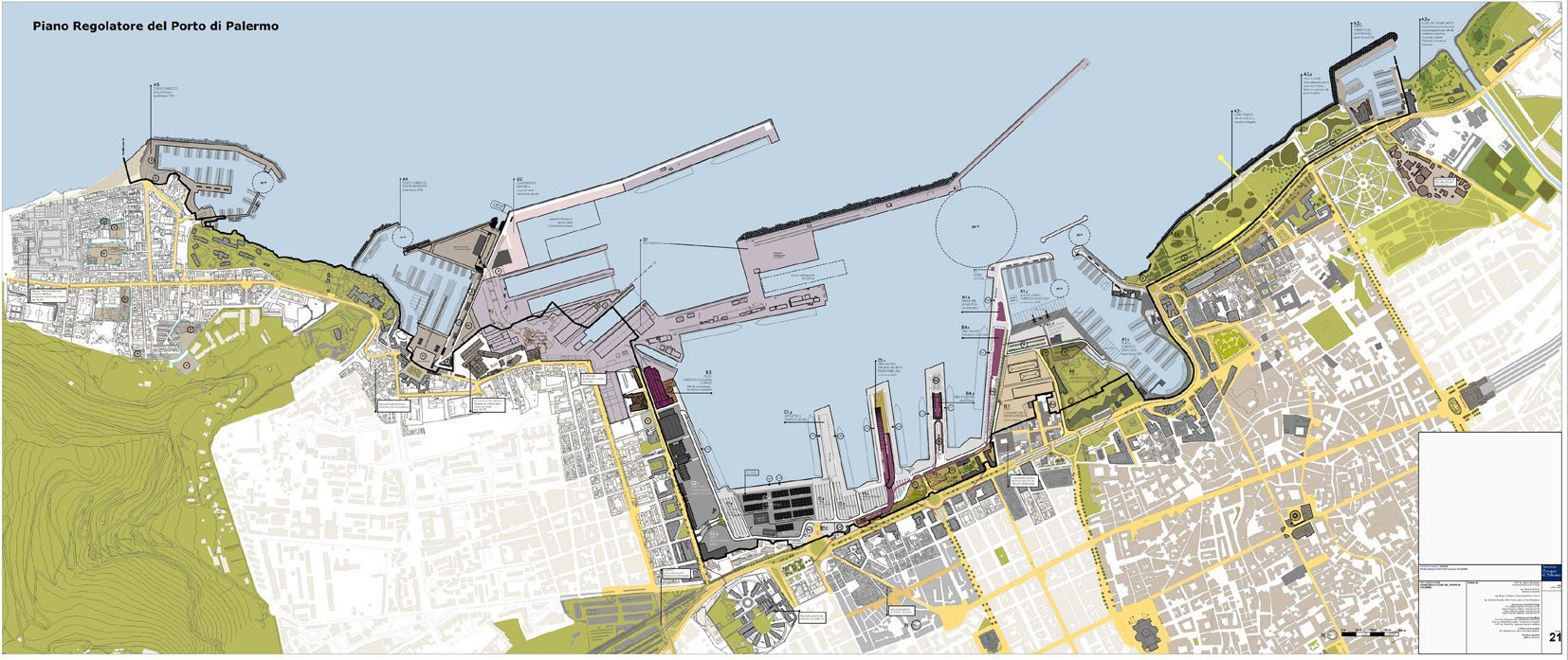
Il Piano Regolatore Portuale del Porto di Palermo approvato nel 2008. (Fonte: Autorità di Sistema Portuale del Mare di Sicilia Occidentale, Piano Regolatore Portuale 2008–2018, Tav. 21).
The Port Master Plan of the Port of Palermo, approved in 2008. (Source: Port System Authority of the Western Sicily Sea, Port Master Plan 2008–2018, Plate 21).
Più che un tradizionale strumento urbanistico, esclusivamente regolativo e conservativo, il nostro Piano fu concepito come una visione complessiva di città, a partire dalla sineddoche del suo porto. L’obiettivo era semplice da enunciare quanto difficile da realizzare: restituire Palermo al mare e il mare a Palermo in una fertile simbiosi mutualistica dove entrambi – la città e il porto – avessero vantaggio dalla ritrovata relazione.
Da questa idea nacque l’immagine della “città liquida” (Carta, Ronsivalle, 2016). Un porto non più pensato come spazio separato, ma come parte integrante dell’organismo urbano, suo elemento costitutivo capace di conformare non solo la porzione costiera ma quasi l’intera città: non una soglia da attraversare, ma un’interfaccia porosa capace di mettere in relazione economie, culture, mobilità e spazi pubblici. Con questo intento, il waterfront venne immaginato come un sistema articolato: alcuni tratti più aperti alla vita urbana e alla nautica da diporto, altri destinati all’incontro tra città e traffici passeggeri, altri ancora riservati alle attività produttive e commerciali. Non una separazione rigida delle funzioni, ma un equilibrio tra esigenze e intensità d’uso diverse all’interno di un unico progetto urbano.
Negli anni successivi quella visione concettuale e metodologica, diventata nel frattempo un paradigma scientifico (Carta, La Greca, Ronsivalle, Lino, 2025), ha iniziato lentamente a materializzarsi.
Dopo un lungo periodo di sospensione caratterizzato da un aspro conflitto istituzionale tra l’Autorità portuale e il Comune – a causa di una persistente contrapposizione politico-istituzionale che impedì di riconoscere pienamente il valore strategico del Piano – finalmente nel 2018 il PRP venne approvato per poter dare nuova forma e rinnovate funzioni a tutta l’area portuale. Subito dopo, la riqualificazione del porticciolo di Sant’Erasmo, la trasformazione del Molo Trapezoidale nel nuovo Palermo Marina Yachting, i progetti per il terminal crociere e il terminal aliscafi e per le nuove interfacce urbane lungo la parte centrale del porto hanno rappresentato i tasselli più visibili di un mosaico più esteso: la progressiva ricucitura del rapporto tra la città e il suo waterfront (Carta, 2025; Lino, 2025).
Guardando oggi questi luoghi è facile soffermarsi sulle architetture, sugli spazi pubblici o sui nuovi affacci sul mare. Più difficile è cogliere il tempo lungo che li ha generati. Eppure, è proprio in quella lunga durata, fatta di visioni, piani, revisioni, ostacoli e realizzazioni, che si trova il significato più autentico della rinascita del waterfront di Palermo.
L’idea alla base del Piano era chiara: il porto non doveva più essere considerato un recinto separato dalla città, ma una sua parte costitutiva. Per farlo occorreva innanzitutto riconoscere che non esisteva un solo porto. Lungo il waterfront convivevano funzioni molto diverse, ciascuna con proprie esigenze operative, spaziali e simboliche. Da questa consapevolezza nacque l’immagine di un porto articolato in tre modalità di relazione con la città.
Il primo era il porto “liquido”, il tratto più prossimo alla vita urbana, destinato alla nautica da diporto, alla cultura, al tempo libero e agli spazi pubblici: un porto attraversabile, capace di mescolarsi con l’esperienza quotidiana dei cittadini. Il secondo era il porto “permeabile”, legato al traffico passeggeri e crocieristico: uno spazio di scambio, nel quale l’apertura alla città doveva conciliarsi con le esigenze di sicurezza e di funzionamento dell’infrastruttura. Il terzo era il porto “rigido”, dedicato alle merci, alla logistica e alla cantieristica, dove efficienza, specializzazione e protezione imponevano una maggiore separazione dagli usi urbani.
Più che una classificazione tecnica, questa tripartizione proponeva un diverso modo di guardare il waterfront: non più come una linea di confine, ma come una sequenza di relazioni differenziate tra città, porto e mare. Da un lato, il Piano puntava a rendere più efficiente la macchina portuale, rafforzandone il ruolo nei traffici del Mediterraneo; dall’altro, mirava a restituire alla città porzioni di lungomare a lungo rimaste inaccessibili.
La vera innovazione del Piano, tuttavia, non risiedeva nella diversa distribuzione delle funzioni portuali, bensì nell’aver trasformato l’interfaccia città-porto nell’oggetto stesso della pianificazione: una fascia porosa, talvolta sottile e talvolta più profonda, capace di estendersi nei tessuti urbani attraverso percorsi, spazi pubblici, visuali, terrazze, luoghi di sosta e nuovi attraversamenti. Non una zona residuale, ma un nuovo paesaggio urbano affacciato sull’acqua, nel quale funzioni portuali e funzioni urbane potessero convivere senza annullarsi reciprocamente.
Da questa impostazione nacque anche la proposta di individuare le cosiddette “aree bersaglio”, poste oltre la stretta giurisdizione portuale ma decisive per ricucire il rapporto tra il porto e i quartieri adiacenti: il Centro Storico, la foce dell’Oreto e l’ex Deposito Locomotive di Sant’Erasmo, l’ex Gasometro, Borgo Vecchio, il Carcere dell’Ucciardone e l’area Sampolo-Mercato Ortofrutticolo, l’ex Manifattura Tabacchi e il quartiere Acquasanta, l’Ospizio Marino e la Tonnara Florio, l’ex Chimica Arenella e il relativo quartiere (vedere l’immagine seguente).
Rather than being conceived as a conventional statutory planning instrument concerned primarily with regulation and conservation, the PRP was designed as a comprehensive urban vision, using the port as a synecdoche for the city as a whole. Its ambition was simple to express yet extraordinarily difficult to achieve: to give Palermo back to the sea, and the sea back to Palermo, through a mutually beneficial relationship in which both the city and the port could flourish through their renewed interaction.
From this vision emerged the concept of the “liquid city” (Carta & Ronsivalle, 2016). The port was no longer conceived as a separate enclave but as an integral component of the urban organism, a constitutive element capable of shaping not only the coastal strip but, potentially, the city as a whole. Rather than a threshold to be crossed, it was envisioned as a porous interface capable of connecting economies, cultures, mobility systems and public spaces. Within this framework, the waterfront was conceived as a differentiated system: some sections were intended to accommodate urban life and recreational boating; others to mediate the relationship between the city and passenger transport; and others still to remain dedicated to productive and commercial activities. The objective was not to impose a rigid functional zoning but to achieve a balanced coexistence of different functions and intensities of use within a single urban project. Over the following years, this conceptual and methodological vision – by then consolidated into a recognised scientific paradigm (Carta, La Greca, Ronsivalle & Lino, 2025) – began slowly to materialise.
Following a prolonged period of institutional deadlock, marked by a bitter conflict between the Port Authority and the Municipality of Palermo – stemming from a persistent political and institutional confrontation that prevented full recognition of the strategic significance of the Plan – the PRP was finally approved in 2018, paving the way for a comprehensive reconfiguration of the port area and the renewal of its functions. Soon afterwards, the regeneration of the Sant’Erasmo marina, the transformation of the Molo Trapezoidale into the new Palermo Marina Yachting, together with the projects for the cruise terminal, the hydrofoil terminal and the new urban interfaces along the central section of the port, became the most visible components of a much broader process: the gradual reconnection of the city with its waterfront (Carta, 2025; Lino, 2025).
Looking at these places today, it is easy to focus on the architecture, the public spaces and the newly accessible views of the sea. It is far more difficult to perceive the long temporal horizon that made them possible. Yet it is precisely within this extended timeframe – shaped by visions, plans, revisions, setbacks and achievements – that the true significance of Palermo’s waterfront renaissance can be understood.
The underlying premise of the Plan was straightforward: the port should no longer be regarded as an enclave detached from the city, but rather as one of its constitutive elements. Achieving this required acknowledging, first and foremost, that there was not one port but many. Along the waterfront coexisted highly differentiated functions, each characterised by distinct operational, spatial and symbolic requirements. From this awareness emerged the concept of a port articulated through three different modes of relationship with the city.
The first was the “liquid port”, the section most closely connected to urban life, devoted to recreational boating, culture, leisure and public space: a permeable port that could merge with the everyday experience of the city. The second was the “permeable port”, associated with passenger and cruise traffic, conceived as a space of exchange where openness to the city had to be reconciled with the operational and security requirements of port infrastructure. The third was the “rigid port”, dedicated to freight transport, logistics and shipbuilding, where efficiency, specialisation and operational safety required a greater degree of separation from urban uses.
Rather than offering a merely technical classification, this tripartite framework proposed a fundamentally different way of interpreting the waterfront: no longer as a line of separation, but as a sequence of differentiated relationships between the city, the port and the sea. On the one hand, the Plan sought to enhance the efficiency and competitiveness of the port within Mediterranean shipping networks; on the other, it aimed to return extensive stretches of the waterfront, long inaccessible to the public, to the everyday life of the city.
The Plan’s most significant innovation, however, lay not in the redistribution of port functions themselves but in redefining the city-port interface as the central object of planning. This interface was conceived as a porous band – sometimes narrow, sometimes extending deep into the urban fabric – structured through pedestrian routes, public spaces, visual corridors, terraces, places for social interaction and new connections across the waterfront. Rather than remaining residual land between two separate worlds, it was envisaged as a new urban landscape overlooking the sea, within which port activities and urban life could coexist without undermining one another.
This approach also gave rise to the proposal to identify the so-called “target areas”, located beyond the strict jurisdiction of the Port Authority yet crucial for reconnecting the port with the surrounding neighbourhoods. These included the Historic Centre; the mouth of the Oreto River together with the former Sant’Erasmo Locomotive Depot; the former Gasworks; Borgo Vecchio; the Ucciardone Prison and the Sampolo Fruit and Vegetable Market area; the former Tobacco Factory and the Acquasanta district; the Ospizio Marino and the Florio Tuna Factory; and finally, the former Arenella Chemical Plant and its surrounding neighbourhood (see following image).

Le “Aree Bersaglio” e le “Aree di Interfaccia Città-Porto”. (Elaborazione degli Autori).
The “Target Areas” and the “City-Port Interface Areas”. (Elaboration by the Authors).
L’obiettivo era definire, attraverso un accordo con il Comune di Palermo finalizzato all’adozione del PRP, indirizzi e strategie per attivare nuovi progetti urbani nelle aree circostanti il porto, affidandone poi lo sviluppo alla pianificazione comunale. Quelle aree, tuttavia, non furono successivamente recepite negli strumenti urbanistici comunali e vennero eliminate dall’intesa approvata dal Consiglio Comunale nel 2011, anche a causa di una persistente contrapposizione politico-istituzionale che impedì di riconoscere pienamente il valore strategico del Piano. Esse tornano oggi di attualità nella fase di redazione del nuovo Piano Urbanistico Generale.
Una volta approvato nel 2018, il PRP ha iniziato a produrre non solo trasformazioni fisiche, ma anche un necessario cambiamento di sguardo: Palermo ha progressivamente smesso di voltare le spalle al porto e ha ricominciato a considerare il mare come spazio di vita collettiva, attivatore di rigenerazione urbana e propulsore di sviluppo.
Tra la visione e la sua realizzazione, tuttavia, si è aperta una lunga distanza. Nel caso del waterfront palermitano sono serviti quasi vent’anni. Dopo l’approvazione regionale del Piano, avvenuta nel 2018, anche grazie al nuovo impulso impresso dall’Autorità di Sistema Portuale, si è avviata una stagione di interventi concreti: la riqualificazione del porticciolo di Sant’Erasmo, completata nel 2019; la trasformazione del Molo Trapezoidale nel Palermo Marina Yachting; i progetti per i terminal crociere e aliscafi; la ridefinizione delle nuove interfacce urbane lungo Via Crispi.
Per affrontare il tratto più delicato del waterfront centrale si è fatto ricorso anche al concorso internazionale di idee bandito dall’Autorità di Sistema Portuale nel gennaio 2018, vinto dallo studio Valle 3.0 di Roma. Le proposte emerse hanno contribuito a tradurre in immagine urbana quella visione che per anni era rimasta affidata ai disegni del Piano.
Fu allora che la città liquida immaginata nei documenti urbanistici cominciò a prendere corpo nello spazio reale, diventando paesaggio urbano sotto gli occhi dei cittadini e dei viaggiatori. Oggi il cantiere dell’interfaccia è vicino al completamento e la sua inaugurazione potrà ampliare ulteriormente le occasioni per vivere Palermo come città d’acqua.
The intention was to establish, through an agreement with the Municipality of Palermo for the adoption of the PRP, a strategic framework capable of guiding new urban regeneration projects in the areas surrounding the port, while entrusting their subsequent implementation to municipal planning instruments. However, these target areas were never incorporated into the city’s statutory planning framework. During the approval process conducted by the City Council in 2011, they were removed from the final agreement, largely as a consequence of the persistent political and institutional conflict that prevented full recognition of the strategic significance of the Plan. Interestingly, these same areas have once again become central to current debates during the preparation of Palermo’s new Municipal Urban Plan.
Following its approval in 2018, the PRP generated not only a series of physical transformations but also a profound shift in the way the city perceived itself. Palermo gradually ceased turning its back on the port and began once again to regard the sea as a collective urban space: a catalyst for regeneration and a driver of economic, social and cultural development.
Between the formulation of the vision and its physical implementation, however, lay a considerable temporal distance. In Palermo’s case, almost twenty years elapsed before the first substantial outcomes became visible. After regional approval of the Plan in 2018, and thanks to the renewed strategic impetus provided by the Western Sicily Sea Port Authority, a new season of concrete interventions began. These included the regeneration of the Sant’Erasmo marina, completed in 2019; the transformation of the Trapezoidal Wharf into Palermo Marina Yachting; the redevelopment projects for the cruise and hydrofoil terminals; and the redesign of the new urban interfaces along Via Crispi.
The redevelopment of the most sensitive section of the central waterfront was also supported by the international design competition launched by the Port Authority in January 2018, won by the Rome-based practice Valle 3.0. The proposals emerging from the competition played a decisive role in translating into an urban image the vision that, for many years, had remained confined to the drawings and strategies of the Master Plan.
It was at this point that the liquid city, long imagined within planning documents, finally began to take shape in physical space, becoming a tangible urban landscape experienced daily by residents and visitors alike. Today, construction of the new city–port interface is approaching completion, and its inauguration promises to further expand the opportunities for experiencing Palermo as a genuine waterfront city.
Una tangibile riconquista
A Tangible Reclamation
E così arriviamo, quasi circolarmente, al luogo da cui siamo partiti. A quel pomeriggio di prima estate in cui ci siamo fermati davanti al mare.
Quel luogo oggi si chiama Palermo Marina Yachting, ma per generazioni è stato semplicemente il Molo Trapezoidale: uno spazio portuale chiuso, occupato da magazzini, depositi e attività indifferenti alla vita della città. Per quest’area, così come previsto dal PRP per le aree di interfaccia e caratterizzate da una forte integrazione tra gli spazi urbano-portuali, fu redatto uno specifico Progetto Integrato di Trasformazione Portuale (PITP) [2] (vedere l’immagine seguente). I PITP sono piani di dettaglio per la progettazione preliminare degli aspetti funzionali, operativi, strutturali e infrastrutturali, ambientali e paesaggistici, anche attraverso concorsi di progettazione in grado di generare il necessario dinamismo e la vitalità progettuale nelle aree più strategiche e interessanti.
And so, we arrive, almost full circle, at the place from which this story began: that early summer afternoon when we paused before the sea.
Today this place is known as Palermo Marina Yachting, but for generations it was simply the Molo TrapezoidalE – an enclosed port area occupied by warehouses, storage facilities and activities largely indifferent to urban life. As envisaged by the PRP for those interface areas characterised by a strong integration between urban and port spaces, this site became the subject of a dedicated Integrated Port Transformation Project (PITP) (see following image). These detailed plans were intended to develop the preliminary design of the functional, operational, structural, infrastructural, environmental and landscape components of the intervention, while also promoting design competitions capable of generating the dynamism and design innovation required for the most strategic sections of the waterfront.

Il Progetto Integrato di Trasformazione Portuale (PITP) per il Palermo Marina Yachting. ‘OAPPC della Provincia di Palermo. (Fonte: Autorità di Sistema Portuale del Mare di Sicilia Occidentale, Progetto Integrato di Trasformazione Portuale (PITP), 2019. Consulenza urbanistica: Maurizio Carta, Barbara Lino, Cosimo Camarda).
The Integrated Port Transformation Project (PITP) for Palermo Marina Yachting. (Source: Port System Authority of the Western Sicily Sea, Integrated Port Transformation Project (PITP), 2019. Urban planning consultancy: Maurizio Carta, Barbara Lino, Cosimo Camarda).
È qui che la visione del Piano è diventata più evidente.
Mentre gli interventi sull’interfaccia attendono di essere completati, il Palermo Marina Yachting rappresenta oggi la prova tangibile di come il rapporto tra città e porto possa essere ripensato. Non soltanto una riqualificazione urbana, ma una vera trasformazione del significato dei luoghi, del loro linguaggio e delle posture d’uso.
Ciò che colpisce, arrivando oggi in quest’area, è la sovrapposizione di tempi e ritmi diversi.
Il Castello a Mare, per secoli nascosto e quasi dimenticato, torna a essere protagonista del paesaggio, le tracce della città storica convivono con nuovi spazi pubblici, con architetture contemporanee e con funzioni legate al turismo, alla nautica e al tempo libero e il porto continua a essere porto, ma allo stesso tempo diventa città, si fa infrastruttura del quotidiano e non solo di trasporto. Dove prima c’erano recinzioni (vedere l’immagine seguente), oggi si susseguono percorsi, piazze, affacci sull’acqua e luoghi di incontro. Il mare torna a entrare nella vita quotidiana dei cittadini e la città torna a riconoscersi nel proprio waterfront.
It is here that the vision embodied in the Master Plan has found its clearest expression.
While work on other sections of the city-port interface is still underway, Palermo Marina Yachting already stands as tangible evidence of how the relationship between the city and the port can be fundamentally reimagined. It represents not merely an exercise in urban regeneration, but a profound transformation in the meaning of place, its spatial language and its patterns of use.
What strikes visitors today is the coexistence of multiple temporalities.
The Castello a Mare, hidden and almost forgotten for centuries, has once again become a defining feature of the urban landscape. The traces of the historic city coexist with new public spaces, contemporary architecture and functions associated with tourism, recreational boating and leisure. The port continues to perform its traditional maritime role, yet at the same time it has become part of the city itself, functioning not only as transport infrastructure but also as an infrastructure of everyday urban life.
Where fences and barriers once stood (see following image), there is now a sequence of promenades, squares, waterfront terraces and places for social interaction. The sea has re-entered the everyday experience of Palermo’s inhabitants, while the city has rediscovered its identity through its waterfront.
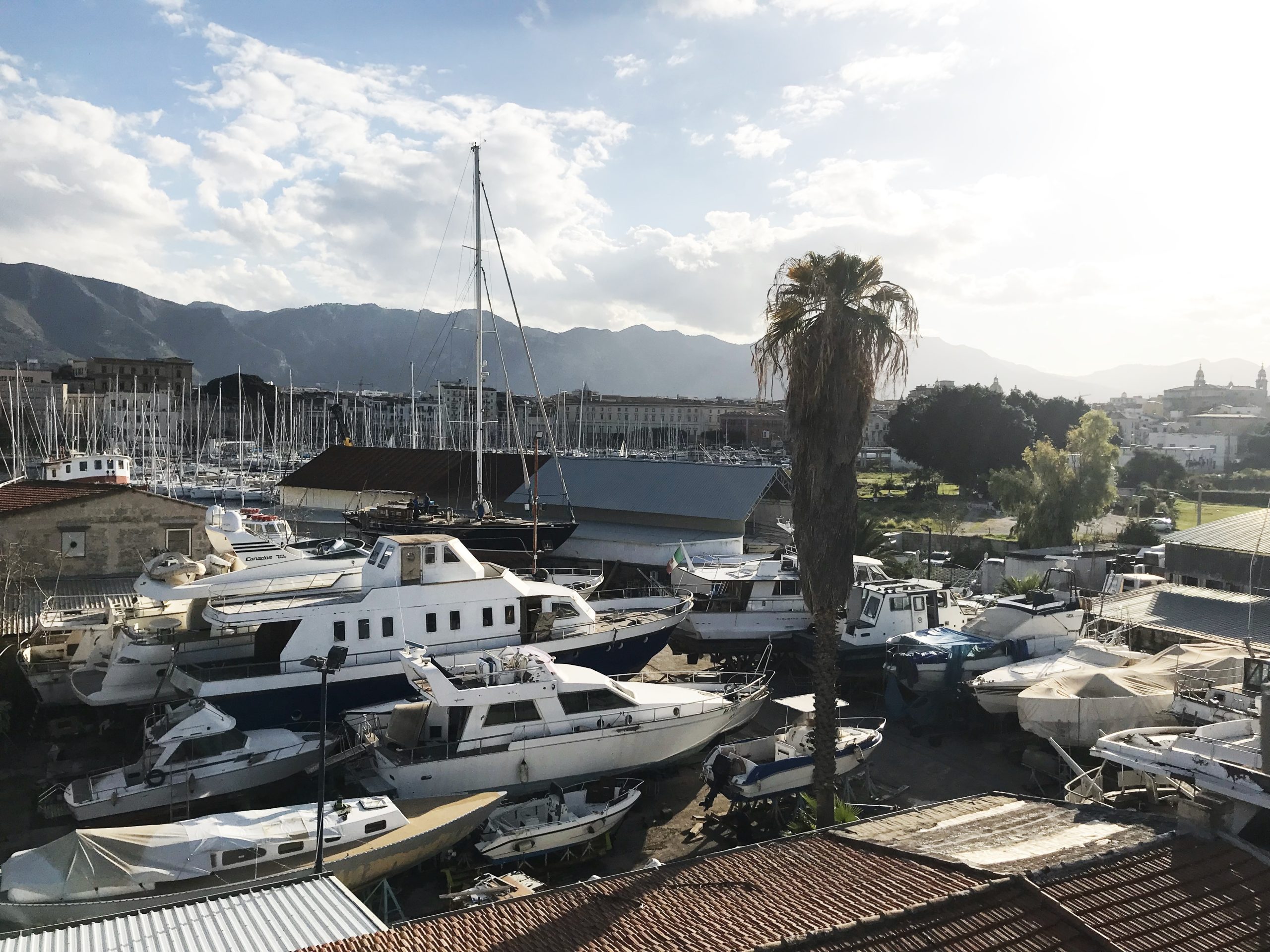
L’area del Molo Trapezoidale prima dell’avvio dei lavori del PITP. (Foto: Barbara Lino).
The Molo Trapezoidale area before the implementation of the Integrated Port Transformation Project (PITP). (Photo: Barbara Lino).
Il progetto ha liberato il Castello a Mare (vedere le immagini seguenti) dalle costruzioni che ne soffocavano la percezione, restituendo alla città un frammento fondamentale della propria storia. Attorno ai bastioni emersi in seguito agli scavi, è stata richiamata l’acqua, quasi a ricostruire simbolicamente il rapporto originario tra la fortezza e il porto. Un gesto semplice ma potente, che ha trasformato un sito archeologico in un nuovo paesaggio urbano.
The project also liberated the Castello a Mare (see following images). from the buildings that had long obscured its presence, restoring to the city one of the most significant fragments of its historical heritage. Around the fortifications brought to light through archaeological excavations, water was reintroduced, symbolically reconstructing the original relationship between the fortress and the harbour. It was a simple yet remarkably powerful gesture, transforming an archaeological site into a new urban landscape.

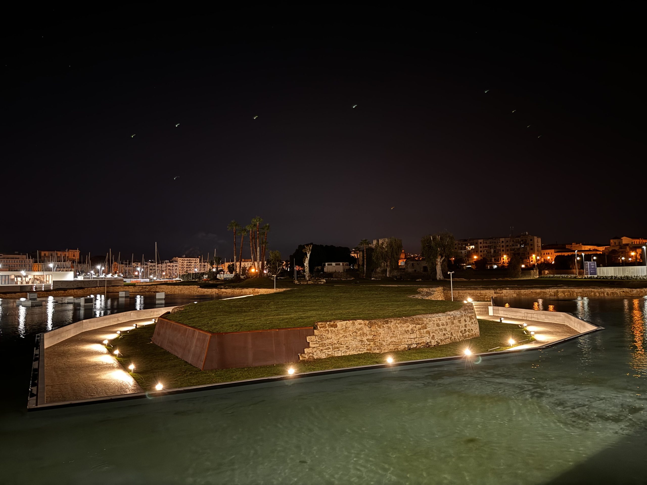
I resti del Castello a Mare (Foto: Maurizio Carta).
The remains of the Castello a Mare (Photo: Maurizio Carta).
Oggi il Palermo Marina Yachting, inaugurato nell’ottobre 2023 alla presenza del Presidente della Repubblica, è molto più di uno spazio riqualificato. È una cerniera tra la città storica, il porto antico della Cala, il sistema crocieristico e il porto turistico: è un luogo in cui si intrecciano memoria e innovazione, patrimonio e trasformazione, cittadini e visitatori (vedere le immagini seguenti).
Today, Palermo Marina Yachting, inaugurated in October 2023 in the presence of the President of the Italian Republic, is far more than a regenerated public space. It has become a hinge connecting the historic city, the ancient harbour of La Cala, the cruise terminal and the marina. It is a place where memory and innovation, heritage and transformation, residents and visitors converge and interact (see following images).
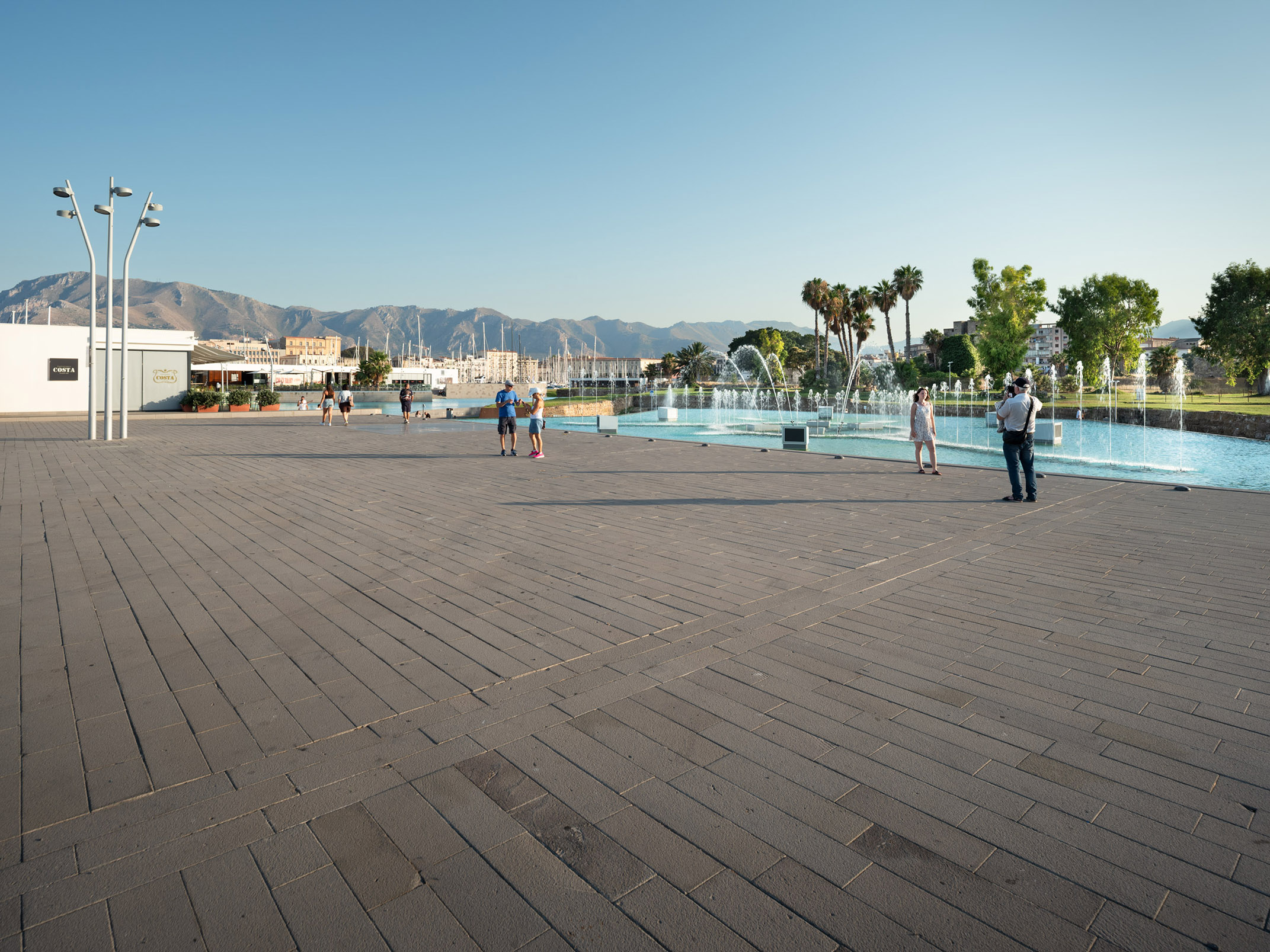
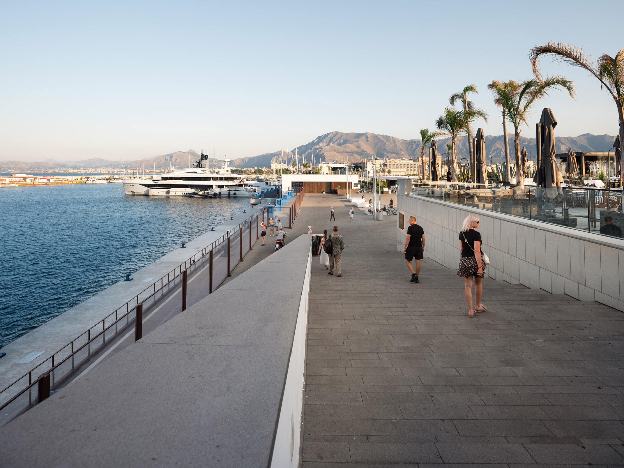
Palermo Marina Yachting. (© Sandro Scalia, 2026).
Palermo Marina Yachting. (© Sandro Scalia, 2026).
Forse è proprio qui che l’idea della città liquida trova la sua rappresentazione più efficace. Non come formula teorica, ma come esperienza concreta. Un luogo nel quale il confine tra porto e città diventa meno netto, dove le funzioni si mescolano e dove il mare smette di essere uno sfondo lontano per tornare a essere parte della vita urbana.
I numeri raccontano soltanto una parte della storia: oltre 40.000 metri quadrati restituiti alla città, più di un miliardo di euro di investimenti sull’intero sistema portuale e oltre un milione di crocieristi che ogni anno attraversano Palermo. Ma ciò che conta davvero è altro: il fatto che Palermo abbia ricominciato a guardare, vivere, odorare, ascoltare il proprio mare. Dopo quasi vent’anni di piani, progetti, concorsi, cantieri e trasformazioni, il waterfront è tornato a essere uno dei luoghi nei quali la città immagina il proprio futuro.
Non si tratta di un processo concluso. Molti interventi sono ancora in corso, altri possono ancora essere realizzati. Ma il percorso intrapreso ha già prodotto un risultato forse inatteso: ha restituito ai cittadini la consapevolezza che il porto non è soltanto un’infrastruttura e che il mare non è soltanto un orizzonte.
Perhaps it is here that the concept of the liquid city finds its most compelling expression – not as an abstract theoretical construct, but as a lived urban experience. Here, the boundary between port and city becomes increasingly permeable; functions overlap and intertwine; and the sea ceases to be a distant backdrop, once again becoming an integral component of everyday urban life.
Statistics capture only part of this story: more than 40,000 square metres of public space returned to the city; over one billion euros invested across the entire port system; and more than one million cruise passengers passing through Palermo each year. Yet these figures fail to express what is perhaps the most significant achievement of all: Palermo has rediscovered the ability to look at, inhabit, smell, hear and ultimately experience its sea. After almost two decades of planning, design, competitions, construction and incremental transformation, the waterfront has once again become one of the places through which the city imagines its future.
This is by no means a completed process. Many interventions are still under construction, while others remain to be realised. Nevertheless, the path that has been set in motion has already produced an outcome that perhaps few had anticipated: it has restored among the city’s inhabitants the awareness that the port is far more than an infrastructure, and that the sea is far more than a distant horizon.
Soglie e continuità dello spazio pubblico oltre i confini portuali
Thresholds and Continuities of Public Space Beyond Port Boundaries
Il percorso di ricucitura tra città e mare non si esaurisce nel porto. Se il PRP aveva ridefinito il rapporto tra Palermo e il suo waterfront centrale, negli anni più recenti quella stessa visione ha iniziato a estendersi a tutti i 26 km dell’intero sistema costiero della città. In questa direzione si collocano le iniziative del Comune di Palermo, le visioni sottese all’elaborazione del nuovo Piano Urbanistico Generale e del Piano di Utilizzo del Demanio Marittimo e gli accordi sottoscritti nel 2023 e il 2025 tra il Comune di Palermo e l’Autorità di Sistema Portuale, volti alla progettazione e alla gestione integrata delle aree di interfaccia città-porto. L’intesa tra i due enti ha rappresentato un passaggio significativo perché trasferisce su scala urbana i principi che avevano guidato il piano del porto: la costruzione di soglie permeabili, la continuità degli spazi pubblici, la cooperazione istituzionale e l’integrazione tra funzioni urbane e portuali.
La costa viene progressivamente interpretata non più come una successione di episodi autonomi, ma come una struttura urbana continua, capace di connettere le principali aree di trasformazione, dalle borgate marinare settentrionali fino alla Costa Sud. In questa prospettiva il fronte a mare diventa la nuova dorsale della città contemporanea (Carta, 2025): uno spazio nel quale si intrecciano rigenerazione urbana, infrastrutture, paesaggio, patrimonio e nuove economie, ricomponendo frammenti che per lungo tempo erano stati affrontati separatamente.
La letteratura internazionale sulla rigenerazione dei waterfront portuali ha da tempo messo in evidenza come i processi di riconversione degli spazi città-porto tendano a seguire traiettorie ricorrenti, spesso fondate sulla dismissione delle funzioni portuali tradizionali a favore di usi turistico-ricreativi (Hoyle, 1989; 2000; Bruttomesso, a cura di, 2006). Altri autori, invece, hanno concettualizzato il waterfront come spazio intrinsecamente ambiguo, sospeso tra pianificazione e informalità, giurisdizione portuale e informalità urbana (Desfor, Laidley, 2011; Hein, 2021). Rispetto a questo dibattito, il caso di Palermo si distingue da molte esperienze europee perché non si fonda sulla dismissione delle attività portuali né sulla loro semplice riconversione in spazi turistici e ricreativi. La strategia perseguita dal Piano è stata invece quella di preservare la complessità funzionale del porto, trasformando non le sue funzioni essenziali, ma la qualità della relazione con la città. L’innovazione risiede dunque nella costruzione di un’interfaccia differenziata, capace di coniugare efficienza portuale, accessibilità urbana e qualità dello spazio pubblico. In questo senso, Palermo propone un modello alternativo di rigenerazione, nel quale porto e città non si sostituiscono reciprocamente, ma imparano a convivere in un nuovo equilibrio dinamico.
The process of reconnecting the city with the sea does not end at the port. While the PRP redefined the relationship between Palermo and its central waterfront, in recent years the same vision has progressively expanded to encompass the city’s entire 26-kilometre coastline. This broader perspective is reflected in the initiatives promoted by the Municipality of Palermo, in the strategic visions underpinning both the new Municipal Urban Plan and the Maritime State Property Use Plan, and in the agreements signed in 2023 and 2025 between the Municipality and the Western Sicily Sea Port Authority for the integrated planning and management of the city-port interface areas. These agreements represent a significant step forward, as they transpose to the urban scale the principles that originally informed the Port Master Plan: the creation of permeable thresholds, the continuity of public spaces, institutional cooperation, and the integration of urban and port functions.
The coastline is therefore being progressively reinterpreted not as a sequence of isolated interventions but as a continuous urban structure capable of connecting the city’s principal areas of transformation, from the northern seaside neighbourhoods to the South Coast. Within this perspective, the waterfront becomes the new backbone of the contemporary city (Carta, 2025): a spatial framework in which urban regeneration, infrastructure, landscape, cultural heritage and emerging economic activities converge, reconnecting fragments that for decades had been planned and managed in isolation.
International scholarship on port waterfront regeneration has long demonstrated that city-port transformation processes tend to follow recurring trajectories, typically characterised by the gradual replacement of traditional port activities with tourism, leisure and recreational functions (Hoyle, 1989, 2000; Bruttomesso, ed., 2006). Other scholars have instead conceptualised the waterfront as an inherently ambiguous space, suspended between formal planning and informality, port jurisdiction and urban appropriation (Desfor & Laidley, 2011; Hein, 2021). Against this background, the Palermo experience differs significantly from many European waterfront regeneration projects because it has not been based on the abandonment of port activities nor on their simple conversion into leisure-oriented urban spaces. Rather, the strategy pursued through the PRP has been to preserve the functional complexity of the port while transforming the quality of its relationship with the city. The Plan’s innovation therefore lies not in altering the port’s essential functions but in constructing a differentiated city-port interface capable of reconciling operational efficiency, urban accessibility and the quality of public space. In this respect, Palermo offers an alternative model of waterfront regeneration, one in which port and city do not replace one another but instead learn to coexist within a new and dynamic equilibrium.
Conclusioni e insegnamenti
Conclusions and Lessons Learned
La storia del waterfront di Palermo mostra come la rigenerazione urbana non possa essere interpretata come la semplice somma di interventi puntuali. Ciò che emerge con maggiore evidenza è il valore di una visione capace di attraversare il tempo, di adattarsi ai cambiamenti istituzionali e di mantenere una direzione comune anche nelle inevitabili discontinuità che accompagnano i lunghi processi di trasformazione.
Se il Piano Regolatore Portuale ha rappresentato il momento in cui è stata ridefinita la relazione tra il porto e la città, la stagione più recente sembra estendere quella stessa prospettiva all’intero sistema costiero e al suo ruolo di nuova dorsale capace di interconnettere un vasto arcipelago di luoghi urbani in vario modo connessi al mare. La redazione in corso del nuovo Piano Urbanistico Generale e l’invio in Consiglio Comunale del Piano di Utilizzo del Demanio Marittimo offrono oggi l’opportunità di affrontare il waterfront come un’infrastruttura territoriale continua, capace di mettere in relazione i diversi paesaggi della costa, le aree di trasformazione, gli spazi pubblici, le nuove economie e i quartieri che vi si affacciano. In questa prospettiva, la pianificazione urbanistica e la rigenerazione urbana cessano di essere ambiti separati e diventano strumenti complementari per costruire una visione condivisa dello sviluppo della città, fornendo un quadro di coerenza agli investimenti pubblici e privati e riducendo il rischio di una frammentazione degli interventi.
La lunga vicenda del waterfront palermitano restituisce anche un’altra lezione. Nessuna delle trasformazioni realizzate sarebbe stata possibile senza la capacità di costruire alleanze tra istituzioni, Autorità Portuale, amministrazioni locali, progettisti, operatori economici e comunità urbane. La disponibilità di risorse finanziarie, pur decisiva, non sarebbe stata sufficiente senza una leadership capace di mantenere viva la visione progettuale e di tradurla progressivamente in programmi, progetti e opere. In questo senso, il partenariato pubblico-privato rappresenta non soltanto uno strumento di finanziamento, ma una delle condizioni attraverso cui la pianificazione riesce a trasformarsi in città costruita.
La trasformazione del waterfront di Palermo racconta, in definitiva, un lungo processo di costruzione collettiva nel quale la ridefinizione del rapporto tra città e porto è avvenuta attraverso continue negoziazioni, adattamenti e forme di cooperazione tra soggetti diversi. Le aree di interfaccia hanno costituito il principale laboratorio di questa sperimentazione, dimostrando come proprio nei luoghi di maggiore complessità possano nascere nuove modalità di collaborazione e nuove visioni condivise.
Da questa lunga vicenda è possibile trarre almeno cinque insegnamenti: una visione può essere più resistente di un singolo progetto; i piani, quando sono capaci di interpretare una struttura profonda della città, possono sopravvivere agli amministratori; le interfacce sono spesso più generative dei confini; il tempo non è un ostacolo esterno, ma uno dei materiali della pianificazione; una buona infrastruttura non produce soltanto mobilità, ma spazio pubblico, riconoscimento collettivo e nuova urbanità.
Oggi il percorso non può dirsi concluso, perché molti interventi devono ancora essere completati e nuove sfide attendono la città, molte delle quali concentrate lungo la dorsale costiera. Tuttavia, il risultato più significativo appare già evidente: Palermo ha ricominciato a riconoscere il mare come parte integrante della propria identità urbana e il waterfront come uno dei principali spazi attraverso cui immaginare il proprio futuro.
Forse è questa la conquista più importante della lunga storia che abbiamo raccontato. Ed è anche la responsabilità più alta dell’urbanistica: non progettare semplicemente nuovi spazi, ma ricostruire relazioni durevoli tra luoghi, istituzioni e comunità, perché una città ritrova davvero il proprio futuro solo quando torna a riconoscersi nei luoghi che abita.
The story of Palermo’s waterfront demonstrates that urban regeneration cannot be understood as the mere aggregation of individual projects. What emerges most clearly is the enduring value of a vision capable of spanning time, adapting to institutional change and maintaining a coherent direction despite the discontinuities that inevitably accompany long-term processes of urban transformation.
If the Port Master Plan represented the decisive moment in redefining the relationship between the port and the city, the most recent phase appears to extend that same vision to the entire coastal system and to its emerging role as the new backbone of Palermo: a spatial structure capable of connecting a vast archipelago of urban places linked, in different ways, to the sea. The ongoing preparation of the new Municipal Urban Plan, together with the submission of the Maritime State Property Use Plan to the City Council, now offers the opportunity to approach the waterfront as a continuous territorial infrastructure, capable of integrating the diverse coastal landscapes, regeneration areas, public spaces, emerging economic activities and neighbourhoods that overlook the sea. From this perspective, urban planning and urban regeneration cease to be separate fields of action and instead become complementary instruments for constructing a shared vision of the city’s development, providing a coherent framework for both public and private investment while reducing the risk of fragmented interventions.
The long history of Palermo’s waterfront also conveys another important lesson. None of the transformations described in this article would have been possible without the capacity to build enduring alliances among public institutions, the Port Authority, local administrations, planners, economic actors and urban communities. Although financial resources were undoubtedly essential, they would not, by themselves, have been sufficient without leadership capable of sustaining the original vision and progressively translating it into programmes, projects and completed works. In this respect, public–private partnership should be understood not merely as a financing mechanism, but as one of the fundamental conditions through which planning is ultimately transformed into the built city.
Ultimately, the transformation of Palermo’s waterfront tells the story of a long process of collective construction, in which the relationship between the city and the port has been continuously redefined through negotiation, adaptation and cooperation among a wide range of actors. The city-port interface areas have served as the principal laboratory for this experimentation, demonstrating that it is often precisely within the most complex spaces that new forms of collaboration and shared visions are able to emerge.
This long experience suggests at least five broader lessons. First, a compelling vision may prove more resilient than any individual project. Second, when plans succeed in interpreting the deeper spatial structure of a city, they are capable of outlasting political administrations. Third, interfaces are often more generative than boundaries. Fourth, time should not be regarded as an external constraint upon planning but rather as one of its essential design materials. Finally, well-conceived infrastructure produces not only mobility but also public space, collective identity and new forms of urbanity.
The process is by no means complete. Many projects remain under construction, while new challenges continue to emerge, many of them concentrated along Palermo’s coastal corridor. Nevertheless, its most significant achievement is already apparent: Palermo has rediscovered the sea as an integral component of its urban identity and the waterfront as one of the principal spaces through which to imagine its future.
Perhaps this is the most important achievement of the long story recounted in these pages. It also represents the highest responsibility of urban planning: not simply to design new spaces, but to rebuild enduring relationships between places, institutions and communities. For a city truly rediscovers its future only when it is once again able to recognise itself in the places it inhabits.
IMMAGINE INIZIALE | Palermo Marina Yachting. (© Sandro Scalia, 2026).
HEAD IMAGE | Palermo Marina Yachting. (© Sandro Scalia, 2026).
╝
NOTE
NOTES
[1] La redazione del Piano Regolatore Portuale (PRP) fu avviata dall’Autorità Portuale nel 2008, su iniziativa del Presidente Nino Bevilacqua, con la consulenza urbanistica di Maurizio Carta. Nell’ambito del team di lavoro, Barbara Lino e Cosimo Camarda hanno contribuito alla definizione degli aspetti urbanistici del piano. La coincidenza dell’autorialità di questo articolo e della redazione del PRP, naturalmente, rischia di far sembrare acritica la descrizione della qualità del piano, ma si rimanda alla nostra etica e alla verifica dei lettori il controllo della veridicità delle affermazioni.
[2] La redazione del piano di dettaglio del Molo Trapezoidale, elaborato da Maurizio Carta con Barbara Lino e Cosimo Camarda per conto dell’Autorità di Sistema Portuale del Mare di Sicilia Occidentale (AdSP), è stata avviata con l’obiettivo di aggiornare la visione progettuale alle esigenze e condizioni del porto e della città nel 2019. Il progetto architettonico è stato sviluppato dall’ufficio tecnico dell’AdSP con la consulenza dello studio di architettura di Sebastiano Provenzano.
[1] The Port Master Plan (PRP) was commissioned by the Port Authority in 2008 under the presidency of Nino Bevilacqua, with Maurizio Carta acting as the urban planning consultant. Barbara Lino and Cosimo Camarda were members of the planning team and contributed to the development of the plan’s urban planning framework. Since the authors of this article were directly involved in preparing the PRP, the assessment presented here may inevitably be perceived as lacking critical distance. The authors therefore rely on their academic integrity and invite readers to assess independently the validity of the arguments and interpretations advanced in this article.
[2] The preparation of the detailed plan for the Molo Trapezoidale, developed by Maurizio Carta together with Barbara Lino and Cosimo Camarda on behalf of the Western Sicily Sea Port Authority (AdSP), began in 2019 with the objective of updating the original planning vision to respond to the changing needs and conditions of both the port and the city. The architectural design was subsequently developed by the AdSP Technical Office with the consultancy of the architectural practice of Sebastiano Provenzano.
RIFERIMENTI
REFERENCES
Bruttomesso, R., a cura di (2006), Città-Porto. Palermo. Catalogo della 10ª Mostra internazionale di architettura, Marsilio, Venezia.
Carta, M., La Greca, P., Ronsivalle, D. & Lino, B. (2025), Planning Complex Waterfront Interfaces Reshaping Port City Regeneration for Sustainable Urban Futures, Springer International Publishing, Cham.
Carta, M. (2025), “Waterfront Palermo: un viaggio lungo venti anni tra tempeste e approdi sicuri”, in PORTUS | Port-City Relationship and Urban Waterfront Redevelopment, 50 (December 2025), RETE Publisher, Venice. ISSN 2282-5789. URL: https://portusonline.org/palermo-waterfront-a-twenty-year-journey-between-storms-andsafe-landings/.
Carta, M., Lino, B. (2021), “Progettare la città liquida. Il Piano Regolatore Portuale di Palermo”, in Carta, M. (ed), Palermo. Biografia progettuale di una città aumentata, LetteraVentidue, Siracusa.
Carta, M. & Ronsivalle, D. eds. (2016), The Fluid City Paradigm. Waterfront Regeneration as an Urban Renewal Strategy, Springer International Publishing, Cham.
Desfor, G. & Laidley, J., eds. (2011), Transforming Urban Waterfronts: Fixity and Flow, Routledge, New York.
Hein, C. (2021). “Port City Porosity: Boundaries, Flows, and Territories” in Urban Planning, 6(3).
Hoyle, B. S. (1989), “The port-city interface: Trends, problems and examples,” in Geoforum, vol. 20.
Hoyle, B. (2000), “Global and Local Change on the Port‐City Waterfront,” in Geographical Review, vol. 90, no. 3.
Lino, B. (2025), “Planning the Fluid City: The Palermo Creative Waterfront”, in Carta, M., La Greca, P., Ronsivalle, D. & Lino, B., Planning Complex Waterfront Interfaces Reshaping Port City Regeneration for Sustainable Urban Futures, Springer International Publishing, Cham.
CARTA, Maurizio, LINO, Barbara and Cosimo CAMARDA. “The Rebirth of the Relationship between Palermo and its Waterfront: A Twenty-Year Urban Planning Story”. PORTUS | Port-City Relationship and Urban Waterfront Redevelopment, 51 (August 2026). RETE Publisher, Venice. ISSN 2282-5789. URL: https://portusonline.org/the-rebirth-of-the-relationship-between-palermo-and-its-waterfront-a-twenty-year-urban-planning-story/