You have to be placed with radical clarity, the scenario of knowledge of the city and its future. The extensive project of “Naples. Atlas of the historic city”, which have been published so far eight volumes by Editions Oikos (Centro Antico, 2002; Quartieri Bassi ed il Risanamento, 2003; Quartieri Spagnoli e Rione Carità, 2004; Dallo Spirito Santo a Materdei, 2005; Stella-Vergini e Sanità, 2006; San Carlo all’Arena e Sant’Antonio Abate, 2007; Pizzofalcone e le Mortelle, 2011; Chiaia, 2012), goes in this direction and now wants to finally just a cycle, one dedicated to the knowledge of the city, lived for territorial and therefore containers of different shapes and times of his life. Follow other directions of knowledge, “the structure of the city” which will identify the significant stages of its formation through monuments and streets that compose it, in general, have not been examined so far in their unity. It is the most comprehensive ever published on the history, urban form and individual architectures in a single city, and it could be that Naples, the largest and most preserved historical cities in the world that still retains all times and the forms of its ancient construction. At the head of a “research patient”, the Atlas just want to reopen the debate on cultural studies and urban planning on the future of the city and of course is the central relationship between the historic city and the sea, between the mesh consolidated its structure and historical the port infrastructure distributed along its coast.

This book divides the city into “parts” that can be treated as knowable facts as such, and not just as parts of a whole. The most important thing that drives this work is an idea that knowledge of a city is not possible to reduce it to a few examples. Has anyone done the tourist, knows that this is how a guide for those who do not have time and that is to reduce the city to a few examples, in saying that you look at these examples mean, condense the city. Here is the Atlas does not do this. No condensation in the city a few examples, does even the opposite to be honest, in the sense that it does not start from an ideological position through where it says “… now I’ll show you that there are strange and extraordinary things that you do not know …”. No simply assumes the position of looking at all that there is, namely, to “suspend judgment” and especially “suspend the pre-judgment” that is not an issue and the only one that makes this Atlas of Naples, something had to be done. The Atlas is not the method. It is not an indication to make an atlas to Milan to Genoa to another and so on. You can do it naturally, but have to say that Naples has a feature and then it is no coincidence that the Atlas is born in Naples: Naples feature is that it saves all the time of his transformation.

Another important issue and that the Atlas is in charge of the city and therefore does not study architecture, which can be found in the city regardless of the city, so it is organized in a territorial sense. The Atlas does not study the planning of the sixteenth or seventeenth and eighteenth centuries, but volume by volume, research phases to phases of research, its parts: from Centro Antico, Quartieri Bassi-Risanamento, Quartieri Spagnoli and Rione Carità and so on; then study the spatial structure, just the “parts” of the city.
Today, a serious word, is the interruption of intellectual prejudices, and myths about the exceptional nature of the city, both on the myths of the need to modernize it, just to go and study it as it is done in its entirety. Here we could find, if not the exceptionality of Naples performed too and said rhetorically, even in Europe and in the world and also from the political that governs us, by politicians who have governed. Now if there is a singularity of Naples, more than one of his uniqueness is that each party shall respond in some way to a law of this city which is one of the stratification of the plans and the time of his transformation. Today we have the whole problem of expansion of the city and the fact that the boundaries of Naples I do not think they are more easily defined. Certainly that is the central theme is the theme of the territory, then the question is how to Naples can become a point of view to look at the world, rather than the characteristics of the difficult research, which has the city and allow to drain within himself the complexity of the world. The Atlas is linked to the very purpose of a speech on time, but not at issue, but the need for a project for the city, promoting the proposal to draft a new “city card”. The City of Naples had great merit in this direction because between 1872 and 1880, drafted a charter extraordinary in scale 1:2000 and drew up before there were the great transformation of cleansing, due to a particular political conjuncture of course economic was determined at that stage.
Now you do not see an explicit statement to the doors of the project, while you feel a desire to project the words of many, but there is also the belief that we are in an era of such transformations that we will encounter in transformation projects. So the Atlas in his final stages of the publishing project has to draw up and publish a map of the entire historical city, in sheets at 1:2000 scale, such as the ‘800 which of course had already been preceded by the Carta of the Duca of Noja, which is instead the eighteenth century.
The cards are tools heroic, because parts of the city feel of something that is going to change, so even a death, not of a death foretold, but something that is inevitable, we cannot avoid. So here is the question of the draft today and the issue of the Atlas, all in all it boils down to a matter and that we try to reduce as much as possible the subjective aspect, to make the project a legitimate, indeed to “establish it”, not because we fear of the subjective, but we fear that a subjective urge, as has been progressively in the second half of the twentieth century, to prevail on the merits of the project.
For these reasons, the court finds that any intervention in the port of Naples or otherwise relating to the transformations on the urban coast, should refer to the knowledge of what is going to transform, in understanding the close relationship, not only within the relationship city-sea, but more generally with other similar cities, which have gone through the same transformation laws. Maybe we are not as important to note that individual interventions along the coast or within the urban waterfront, but most important thing is to find the connections that have formed strong structural and functional relationships with the old urban structure. Try to work on the existing building structure with surgical grafts urban vertical and perpendicular to the coast. From this point of view, for example, might find Naples, an reborn his identity by connecting with a more effective urban mobility policy, the pole with the axis of Capodimonte-Toledo to Via Cesario Console (Piazza del Plebiscito) or connect the top the fortress of Castel Sant ‘Elmo with the dense urban fabric that stretches along the hill of San Martino to the sea of Via Caracciolo, crossing the Villa Comunale, then throw on the large terrace overlooking the sea, commonly called the promenade of the “Lungomare”.
The knowledge and the study of urban phenomena allow us to define a strategy with conviction complex and articulated like this, throwing away a vulgar politics of the day-to-day emergencies or the chase continued. The Atlas is a fundamental tool to embrace this new policy and the place to open a large local and international comparison so that we can give effective answers to the height of our “time “.
Head image: Picture of the poster on the Atlas of Historic City of Naples on display at the Expo 1992 of Seville.
L’Atlante della Città Storica di Napoli: uno strumento di conoscenza per capire la città e il suo rapporto con il mare
Bisogna collocarsi con radicale nettezza, sullo scenario della conoscenza della città e sul suo futuro.
Il grande progetto di “Napoli. Atlante della città storica”, di cui sono stati pubblicati sino ad ora otto volumi per Edizioni Oikos (Centro Antico, 2002; Quartieri Bassi ed il Risanamento, 2003; Quartieri Spagnoli e Rione Carità, 2004; Dallo Spirito Santo a Materdei, 2005; Stella-Vergini e Sanità, 2006; San Carlo all’Arena e Sant’Antonio Abate, 2007; Pizzofalcone e le Mortelle, 2011; Chiaia, 2012), va in questa direzione e vuole per adesso concludere un ciclo, quello appunto dedicato alla conoscenza della città, vissuta per ambiti territoriali e perciò contenitori di tempi e forme diverse della sua vita. Seguiranno altre direzioni di conoscenza, come quella della “struttura della città” che individuerà le tappe significative della sua formazione, attraverso monumenti e strade che la compongono, in generale finora non esaminati finora nella loro unitarietà. Si tratta dell’opera più completa mai pubblicata sulla storia, la forma urbana e le singole architetture di una singola città, e non poteva essere che Napoli, la più estesa e conservata città storica del mondo che, ancora oggi, conserva tutti i tempi e le forme della sua millenaria costruzione. A capo di una “ricerca paziente”, l’Atlante vuole appunto riaprire il dibattito culturale sugli studi urbani e sul futuro urbanistico della città e, per questo, ovviamente risulta centrale il rapporto tra la città storica ed il mare, tra la maglia consolidata della sua struttura storica e l’infrastrutturazione portuale distribuita lungo la sua costa.
Particolare dell’Atlante della Città storica di Napoli, Expo 1992 di Siviglia.
Quest’opera divide la città in “parti” che possono essere trattate come dei fatti conoscibili in quanto tali e non solo come parti di un tutto. La cosa più importante che spinge questo lavoro è l’idea che la conoscenza di una città non sia possibile ridurla ad alcuni esempi. Chiunque ha fatto il turista, sa che questa è la modalità di una guida per chi non ha tempo e cioè dire “guardate che questi esempi significano, condensano l’intera città”. Ecco l’Atlante non fa questo. Non condensa la città in alcuni esempi, non fa nemmeno il contrario a dir la verità, nel senso che non parte da una posizione ideologica attraverso cui si dice “… ora vi faccio vedere che esistono cose strane e straordinarie che voi non conoscete …” No, semplicemente assume la posizione di guardare tutto quello che c’è, vale a dire, di “sospendere il giudizio” e soprattutto “sospendere il pre-giudizio” che è una questione, e non l’unica, che fa di questo Atlante di Napoli, qualcosa che doveva essere fatto. L’Atlante non è metodo. Non è una indicazione per fare un Atlante a Milano, un altro a Genova e via dicendo. Si possono fare naturalmente, però c’è da dire che Napoli ha una “sua” caratteristica e che, pertanto, non è un caso che l’Atlante nasca a Napoli: questa caratteristica è che Napoli conserva tutti i tempi delle sue trasformazioni.
Le otto copertine dei volumi sino ad ora pubblicati per il progetto editoriale “Atlante della Città Storica di Napoli”, Edizioni Oikos.
Un’altra questione importante è che l’Atlante si occupa della “città” e quindi non studia le architetture che si ritrovano nella città, indipendentemente dalla città, e per questo è organizzato in senso territoriale. L’Atlante non studia l’urbanistica del Cinquecento, del Seicento o del Settecento, bensì volume per volume, fasi di ricerca per fasi di ricerca, le sue “parti”: la Sanità, i Vergini, i Quartieri Spagnoli, il Centro Antico e via dicendo. Studia quindi la struttura territoriale, appunto le “parti”della città.
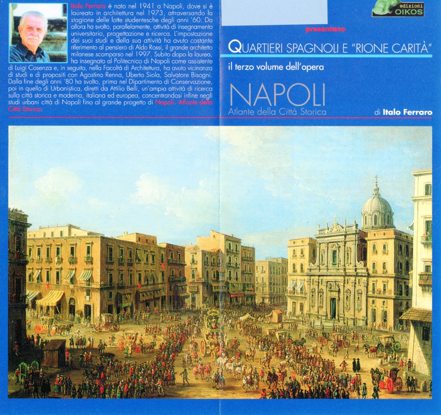
Copertina del terzo volume “Quartieri Spagnoli e Rione Carità”, Edizioni Oikos. (2004)
Oggi un concetto interessante è quello dell’interruzione dei pregiudizi, sia sui miti dell’eccezionalità della città, sia sui miti della necessità di modernizzarla, proprio per andare a studiarla per come è fatta nelle sue parti. Se c’è una singolarità di Napoli, più che una sua eccezionalità, è che ogni parte risponde in qualche modo ad una legge di questa città, che è quella della stratificazione dei piani e dei tempi della sua trasformazione. Noi oggi abbiamo il problema della dilatazione della città ed il fatto che i confini di Napoli non credo siano più facilmente definibili. Certamente il tema che risulta centrale è il tema del territorio: allora la questione è su come Napoli può diventare un punto di vista per guardare il mondo, piuttosto della difficile ricerca delle caratteristiche, che permettono di esaurire dentro di sé la complessità del mondo. L’Atlante si lega molto al proposito di un discorso puntuale, al bisogno di un progetto per la città, di promuovere la proposta di redigere una nuova “carta della città”. Il Comune di Napoli ha avuto grandi meriti in questa direzione perché tra il 1872 ed il 1880, ha redatto una carta straordinaria, in scala 1:2000, prima che ci fossero le grandi trasformazione del Risanamento, dovute ad una particolare congiuntura politica ed economica. Ora non si vede esplicitata una dichiarazione di progetto, mentre si avverte una volontà di progetto nelle parole di tanti, ma c’è anche la convinzione che ci troviamo in un’epoca di tali trasformazioni che andremo incontro a dei progetti di radicale trasformazione. Quindi l’Atlante, tra le sue fasi conclusive, ha il programma editoriale di redigere e pubblicare una carta di tutta la città storica, in fogli in scala 1:2000, come quella dell’800, che naturalmente era già stata preceduta dalla carta, settecentesca, del Duca di Noja.
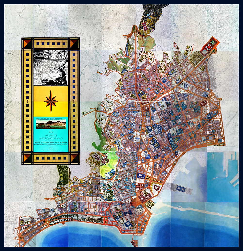
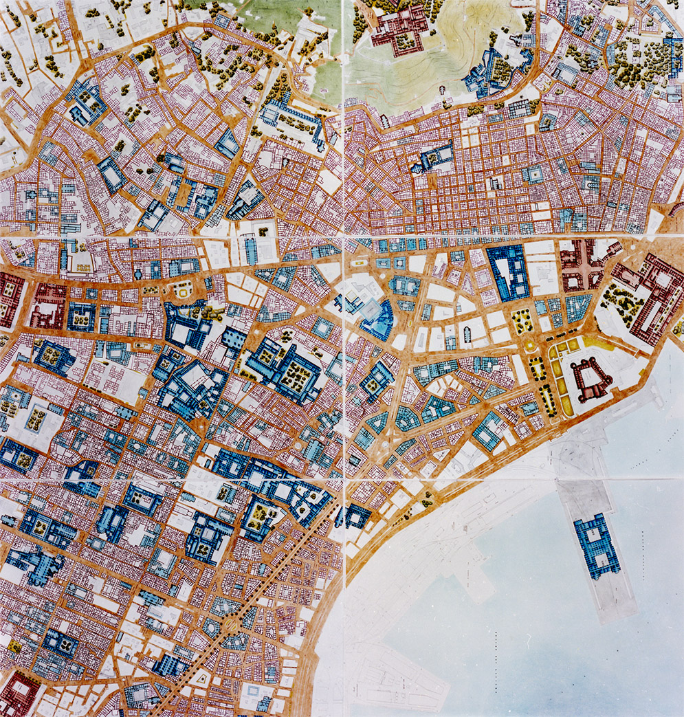
Quadro d’insieme dell’intero Centro Storico di Napoli composto da 35 pannelli, redatto in occasione dell’esposizione “Atlante della Città storica di Napoli”, Expo 1992 di Siviglia.
Le carte sono strumenti “eroici”, perché le parti delle città avvertono di qualcosa che sta per cambiare, quindi anche di una morte, non annunciata, ma di qualcosa che è inevitabile. Ecco allora che la questione del progetto di oggi e la questione dell’Atlante, tutto sommato, si riducono ad un proposito: quello cioè di cercare di ridurre quanto più possibile l’aspetto soggettivo, per rendere il progetto “legittimo”, per “fondarlo”. E questo non perché si tema dell’aspetto soggettivo, ma temiamo che una spinta soggettiva, come è avvenuto progressivamente nella seconda parte del Novecento, prevalga sulla fondatezza del progetto.
Particolare dell’Atlante della Città storica di Napoli, Expo 1992 di Siviglia.
Per questi motivi si deve ritenere che qualsiasi intervento nell’area portuale di Napoli o comunque inerente alle trasformazioni sulla costa urbana, deve fare riferimento alla conoscenza di ciò che si va a trasformare, capirne le strette relazioni, non solo all’interno del rapporto città-mare, ma più in generale, con altre città consimili, che hanno vissuto analoghe vicende di modificazione. Forse potremo notare che non sono così importanti i singoli interventi sul lungo costa o nell’ambito del waterfront urbano, ma che è invece essenziale ritrovare i nessi che hanno costituito le relazioni strutturali e funzionali con la vecchia città. Provare ad operare sulla struttura edilizia esistente con chirurgici innesti urbani verticali e perpendicolari rispetto alla costa.
La conoscenza e lo studio dei fenomeni urbani ci permettono di definire con convinzione una strategia complessa ed articolata come questa, gettando alle ortiche una volgare politica del “giorno per giorno” o di rincorrere le continue emergenze. L’Atlante è strumento fondamentale per abbracciare questa nuova politica e la sede adatta per aprire un grande confronto locale ed internazionale affinché si possano dare efficaci risposte all’altezza del nostro “tempo”.
Immagine di apertura: Immagine della locandina riguardante l’Atlante della Città storica di Napoli esposto all’Expo 1992 di Siviglia.