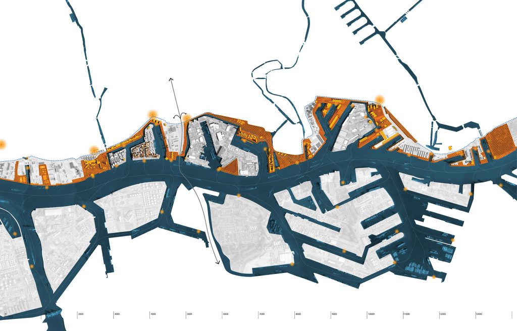
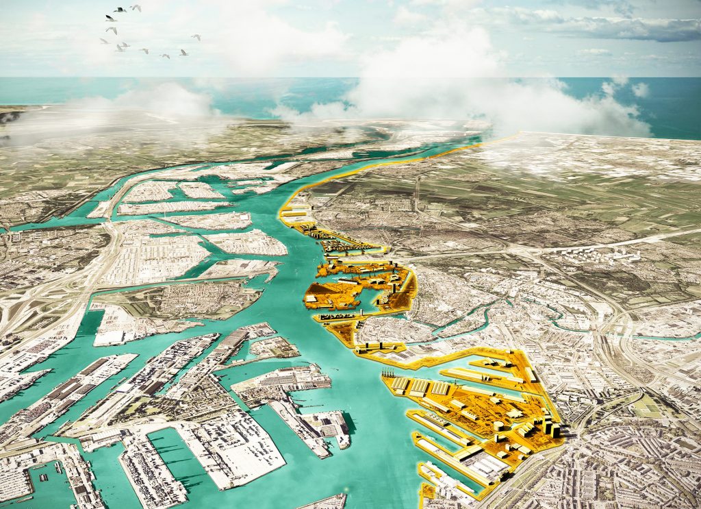
The Archipelago of Knowledge is a new spatial strategy for the Port of Rotterdam, the Netherlands, that aims to reconsider the relationship between harbor and city. Through the redefinition of areas within the port, our proposal aims to create a series of artificial islands by digging new canals, multiplying waterfronts and subsequently enabling the formation of a continuous, 100% public accessible, waterfront. The urban and ecological potential embedded in the direct relationship between city and water, is re-established and enhanced, benefitting both citizens and the maritime clusters. The new linear waterfront finally brings water back to the city – a city that often lacks a direct relationship with its largest water body, the Maas River, despite its close proximity and historical and cultural significance.
The waterfront can become a shared space where the interests and needs of various stakeholders are confronted and negotiated, in order to find points of intersection and mutual interest that can be reflected in the new spatial configuration. In our vision, this port area becomes an archipelago, where new islands are spatially defined areas where economic and planning scenarios can unfold through time. Although their shape is fixed, their program, be it maritime, commercial, residential or recreational, can adaptively occupy the space according to future economic trends, political and logistic decision making processes, ensuring a new beneficial relationship between port and city. Port expansion has always implied dramatic transformations of the river landscape, of geographic proportions. As a matter of fact, the port has expanded and transformed through time, occupying more and more surface and reducing the public accessibility to the river. The time has come, now, with changing conditions of the port economy, to re-orient land transformations to the advantage of the city, people and biodiversity.
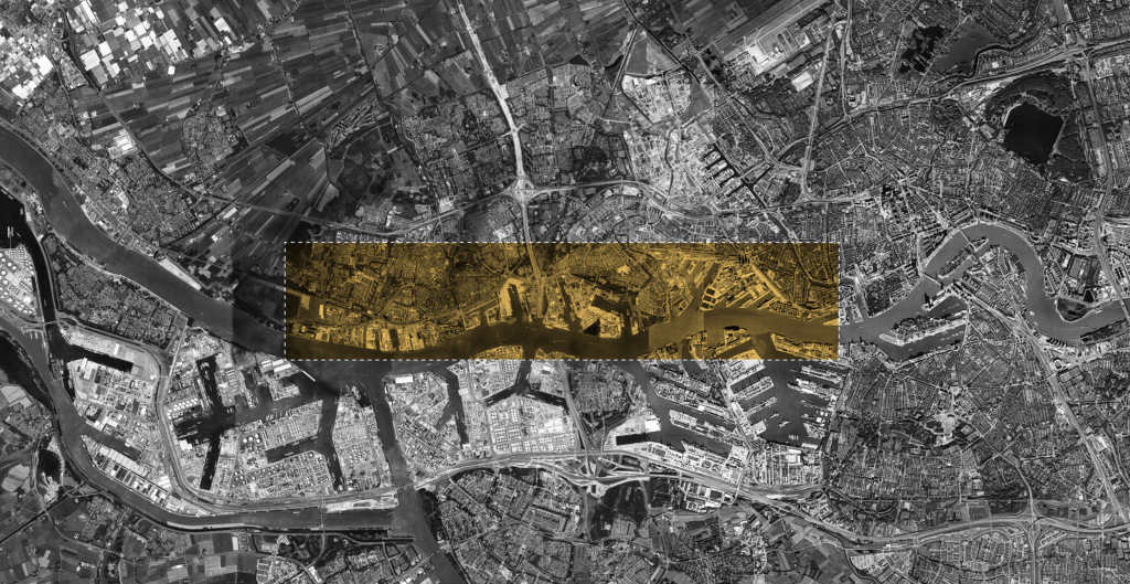
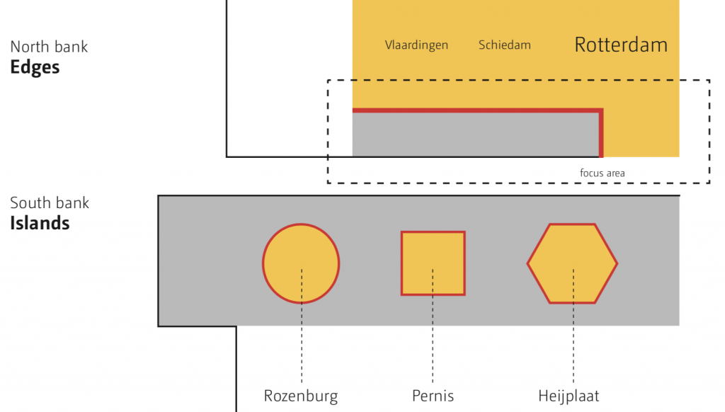
Focus area | a condition rather than a location
The settlement patterns on the North and South bank of the Maas River are uniquely distinct. On the South bank of the Maas, the municipalities can be described as islands, largely isolated from each other and surrounded by industrial land-use. The North bank of the Maas, our study area, is defined by a more continuous urban pattern, where municipalities are well connected on a local and regional scale by more efficient transportation systems. This area is characterized by co-existence of industrial with a continuous urban fabric, a robust water system and a higher degree of public accessibility to water.
A Case | learning from Unilever
Studying existing cases of major spatial transformation within our study area, is important for understanding the dynamics of specific entities and how their past, present, and future operations and decisions relate to the attractiveness (or lack thereof) for the port of Rotterdam.
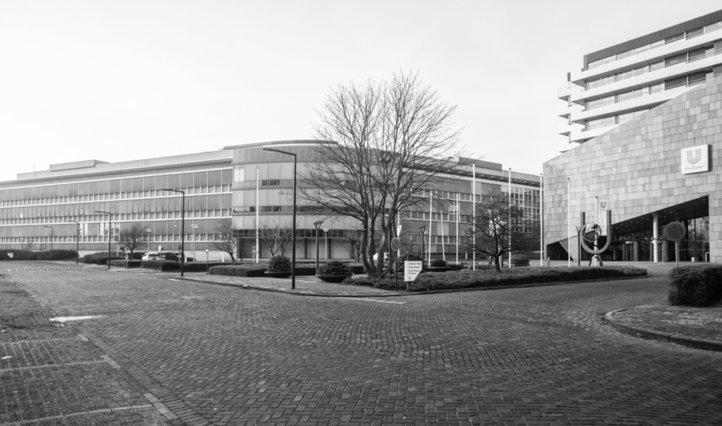
A relevant example is the company Unilever that has left the port area, perceived as industrial and disconnected. It has recently partnered with Wageningen University to relocate its global Foods Innovation Centre It has recently partnered with Wageningen University to relocate its global Foods Innovation Centre to the Wageningen in favor of the rich scientific environment of the campus and an area that is often referred as “Food Valley”.
This decision raises several questions and serves to understand relations between a specific multinational company and the port, more in depth. Unilever left the port area, perceived as industrial and disconnected, in favor of the rich scientific environment of the campus. While the benefits from the newly-established proximity to the university are many, the benefits of its former connection to the port infrastructure and its unique identity, are lost.
Goal | new and diversified employment opportunities
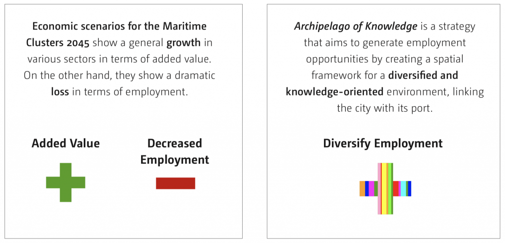
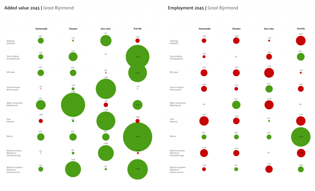
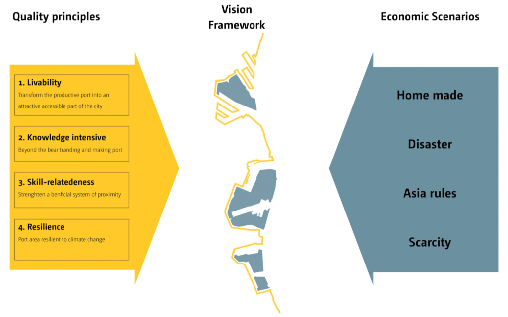
The departure of Unilever seems to align with a study on economic scenarios for the so-called maritime clusters in South Holland with a perspective of 2045 [2] that project a dramatic loss in terms of employment (as well as a general growth in various sectors in terms of added value). Responding to those scenarios, our vision “Archipelago of Knowledge. A diffuse campus” is a strategy that aims to generate employment opportunities by creating a spatial framework for a diversified and knowledge-oriented environment, linking the city with its port.

Path dependency | about time and decisions
Such a proposal engages with recent discussions in the field of port city research related to path dependencies and ways to initiative new path ways in order to define a new, stronger, spatial relation.
“Diverging interests of both the city government, Port Authority, and the regional and national governments lead to the emergence of two independent spaces (port and city) governed by separate sets of institutions, tools, methods, laws, ideas, and even different time frames’’ (Paolo de Martino) [3]. In the last few decades, though, there have been ideas and campaigns addressing the need for integration between city and port. Now, the long- lived path dependence needs to be ‘broken’ in order to define a new, stronger, spatial relation.
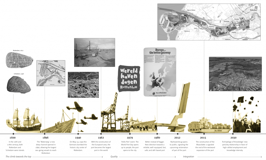
A dynamic past
Port expansion has always implied dramatic transformations of the river landscape. The port has expanded and transformed through time, occupying more and more surface. The time has come, now, with changing conditions of the port economy, to re-orient land transformations to the advantage of the city and its people.
Fragmentation | lack of integration
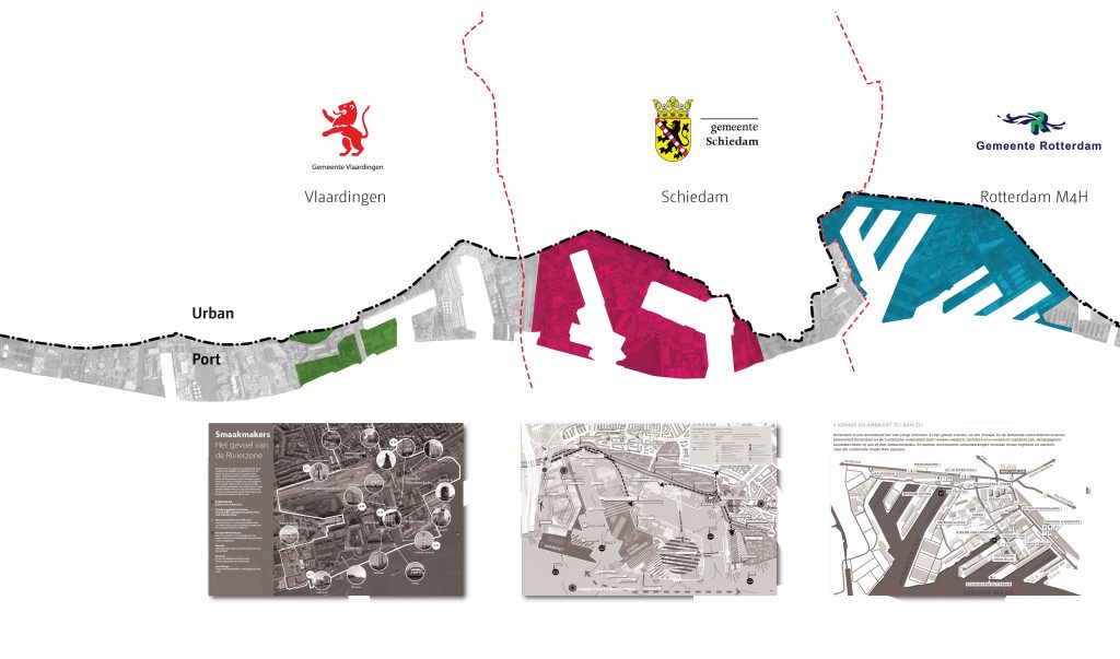
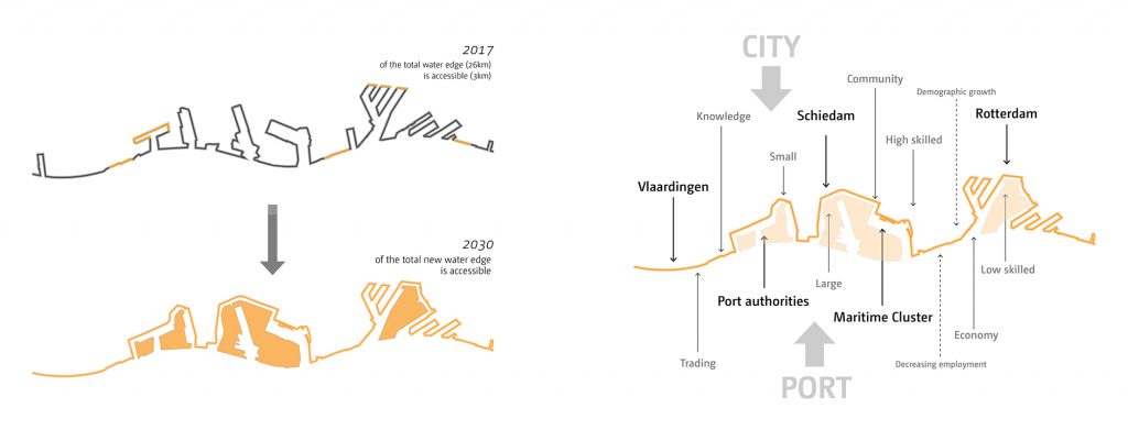
The municipalities of Rotterdam, Schiedam, and Vlaardingen, despite being generally well connected in terms of urban fabric and transportation networks, each have distinct plans and approaches that drive the future developments of their waterfront. These plans can be considered ‘balconies’ to the Maas; they are independent, creating a fragmented edge.
Mobility
Public transportation systems create strong connectivity in the port area. On the north side of the study area, the existing railway line has been transformed in 2017 into a metro system linking Rotterdam, Schiedam and Vlaardingen. On the south side, the Maas is currently used by water-taxi and water-bus lines for public transportation on the river, and bears a great potential of being further developed.
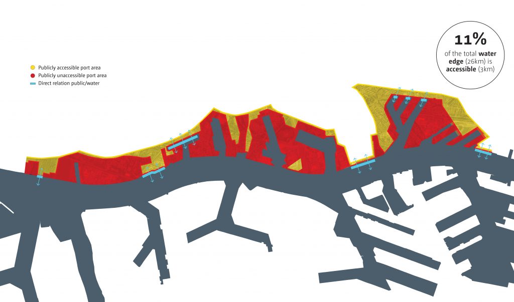
Access vs egregation
Access to the port is very limited and only 11% of the total water edge is reachable by the public, resulting in a segregated landscape. While several areas are incompatible with urban life and need to remain isolated from the city, many other bear the potential of retaining their productive capacity while becoming accessible to the public.
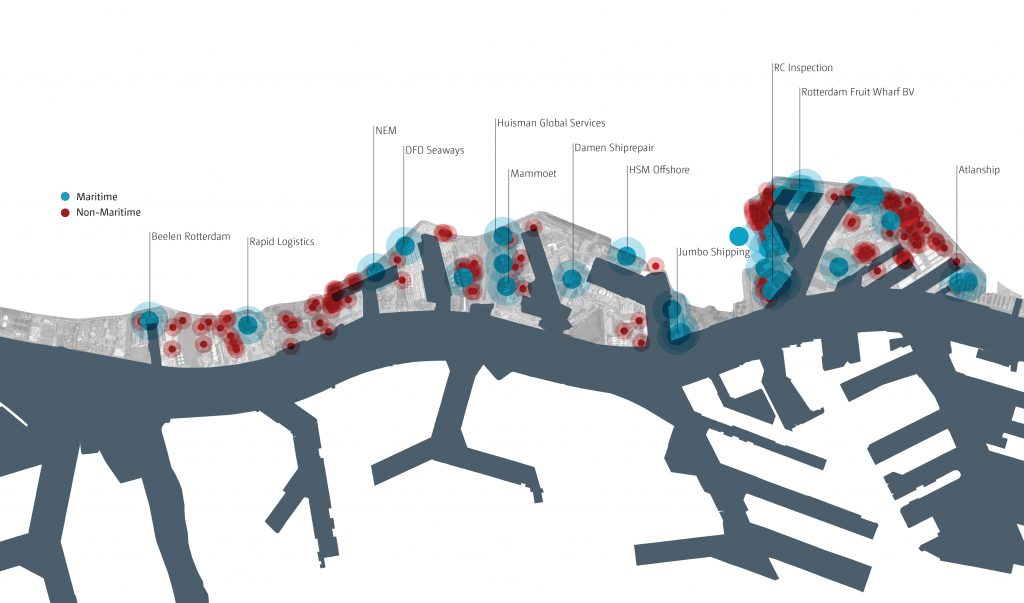
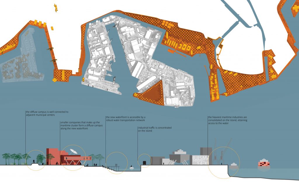
Companies | maritime vs non-maritime
The maritime clusters are spatially defined areas where partner companies are gathered.
The scale of the enterprises varies dramatically: the large ones need water access, docks, and large scale infrastructures for transportation, manufacturing, processing, storage, and security, while the small ones do not. Currently maritime and non- maritime companies are interspersed, with smaller companies isolated from the urban fabric.
A great potential exists for spatial reorganization to optimize relationships between the companies, the waterfront, and the city.
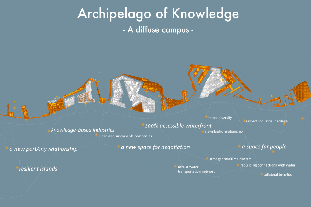
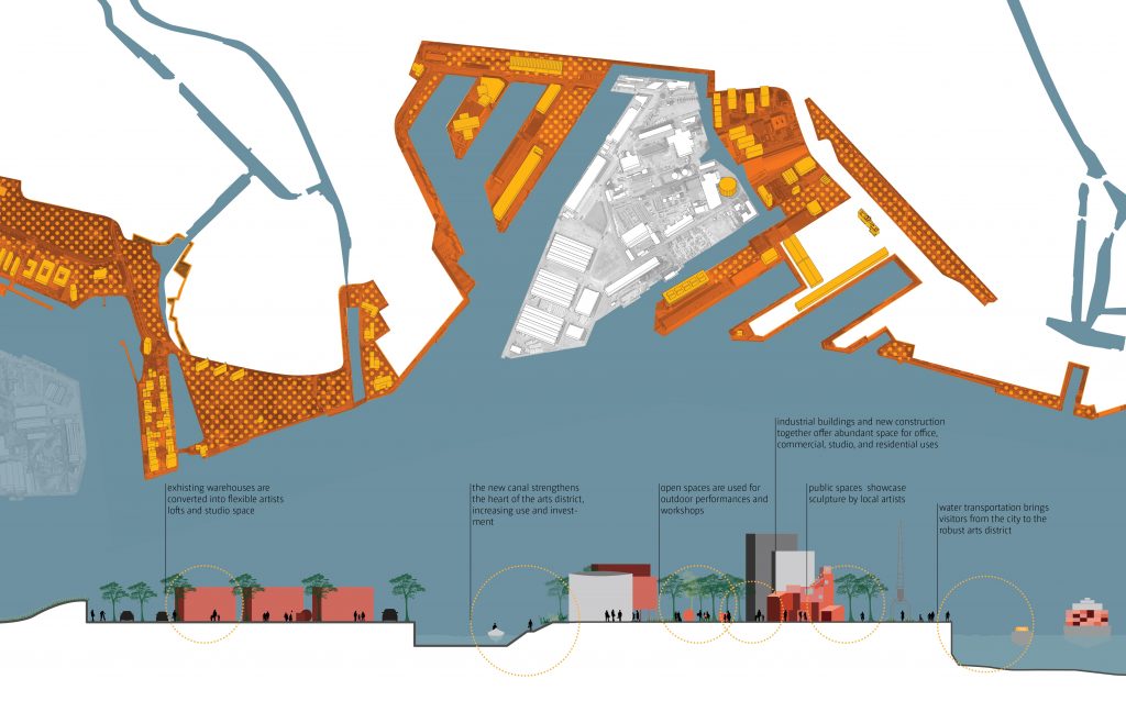
Archipelago of Knowledge | new port-city relationship
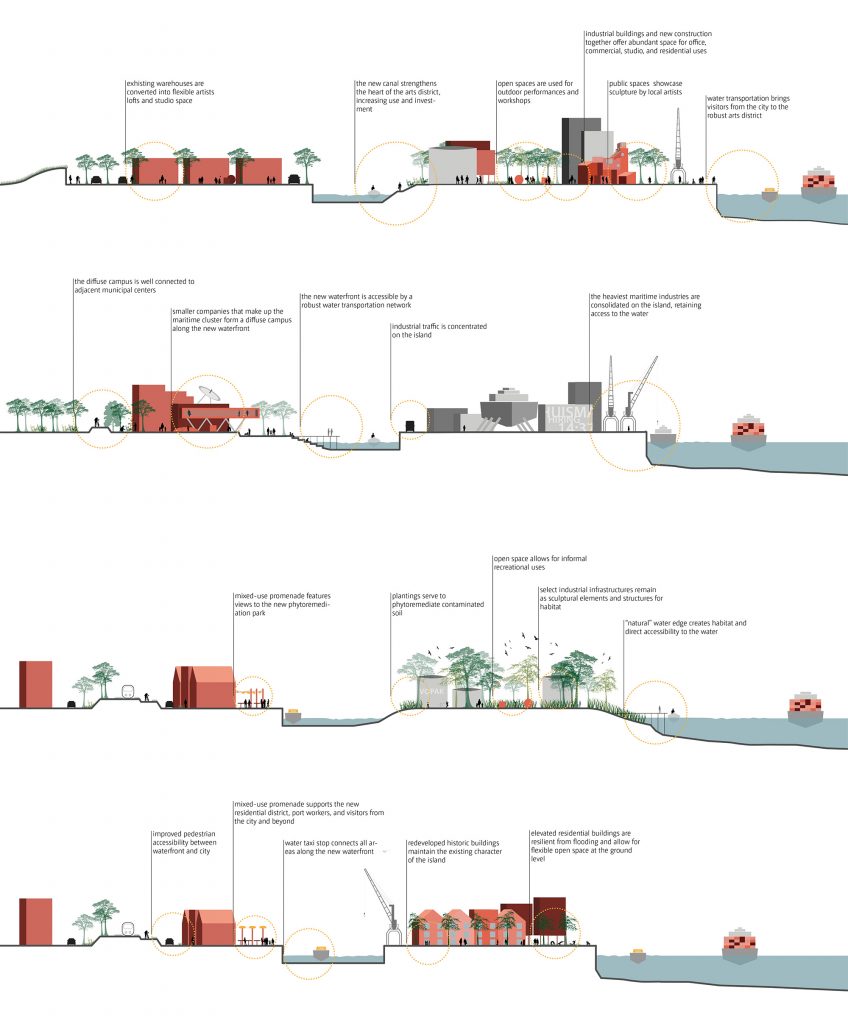
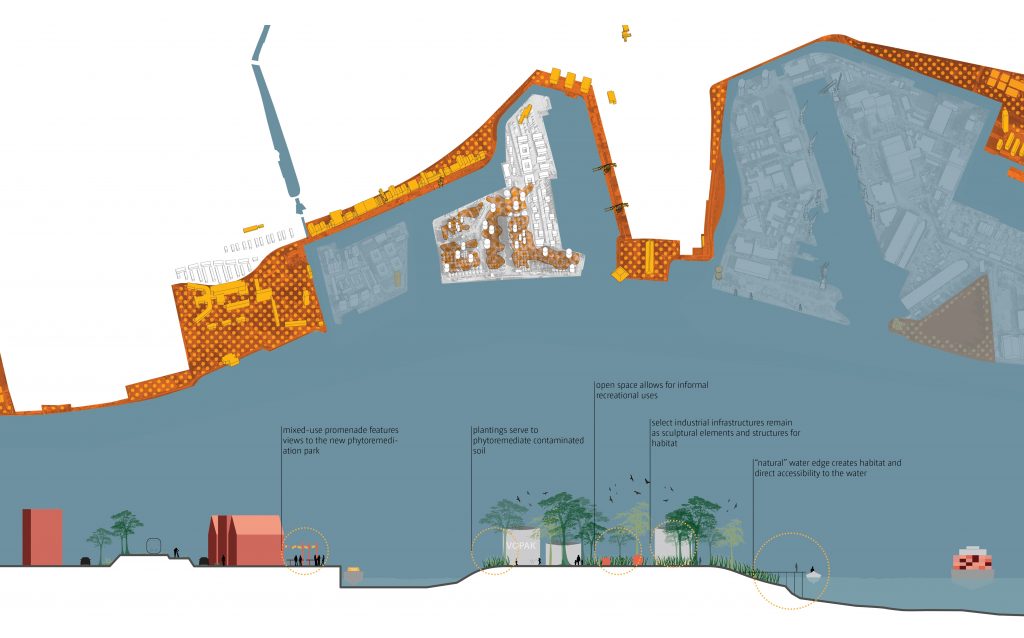
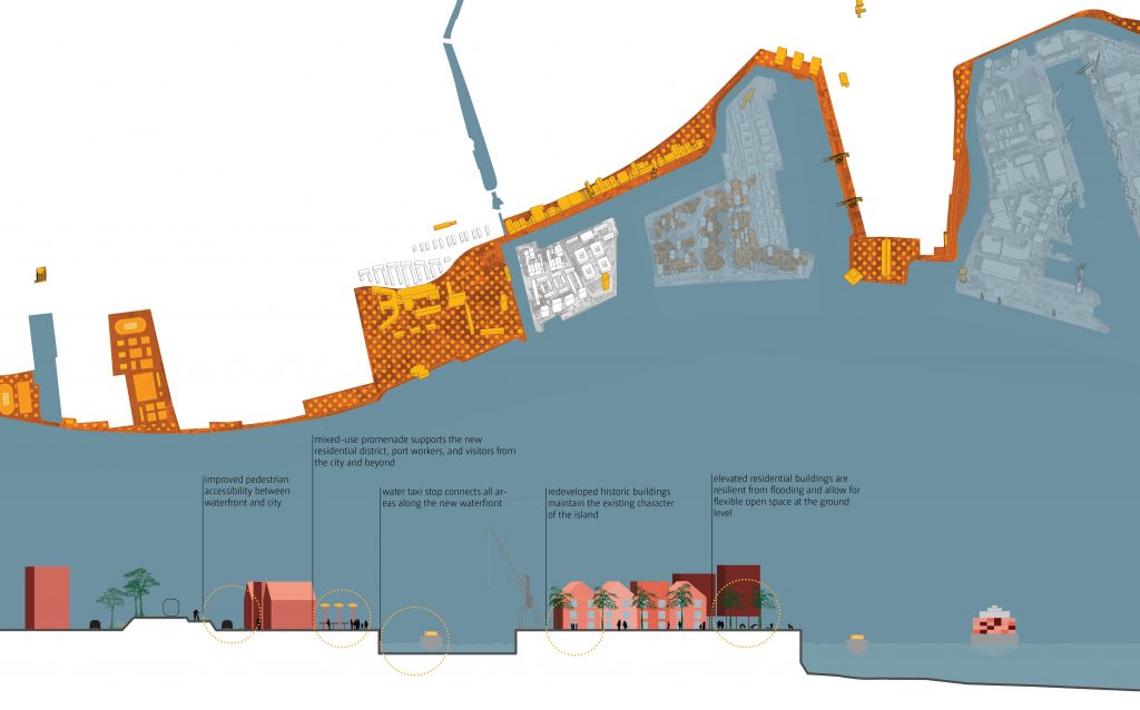
“Archipelago of Knowledge. A diffuse Campus” is a new spatial configuration that reconsiders the relation between port and city. In a speculative fashion, our vision proposes to create an archipelago of commercially active areas -islands-, resulting in the formation of a continuous, 100% accessible waterfront. The quality embedded in the direct relationship between city and the water is re-establish and enhanced, for the benefit of the citizens and the maritime cluster.
Waterfront | a shared space for negotiation
A new unfolded linear space, a continuous waterfront, is envisioned for the area. The new system can finally bring back water to the city that, although in close proximity to water, often lacks a direct relationship with its largest water body, the Maas River. The waterfront is a system that goes beyond administrative boundaries and fragmentation, but rather unifies the ongoing efforts of port revitalization into one, coherent urban vision. The strategy itself, before its implementation, can be seen as the tool to bring all the different actors together at the same table; actors from the city, the maritime cluster, and the port.
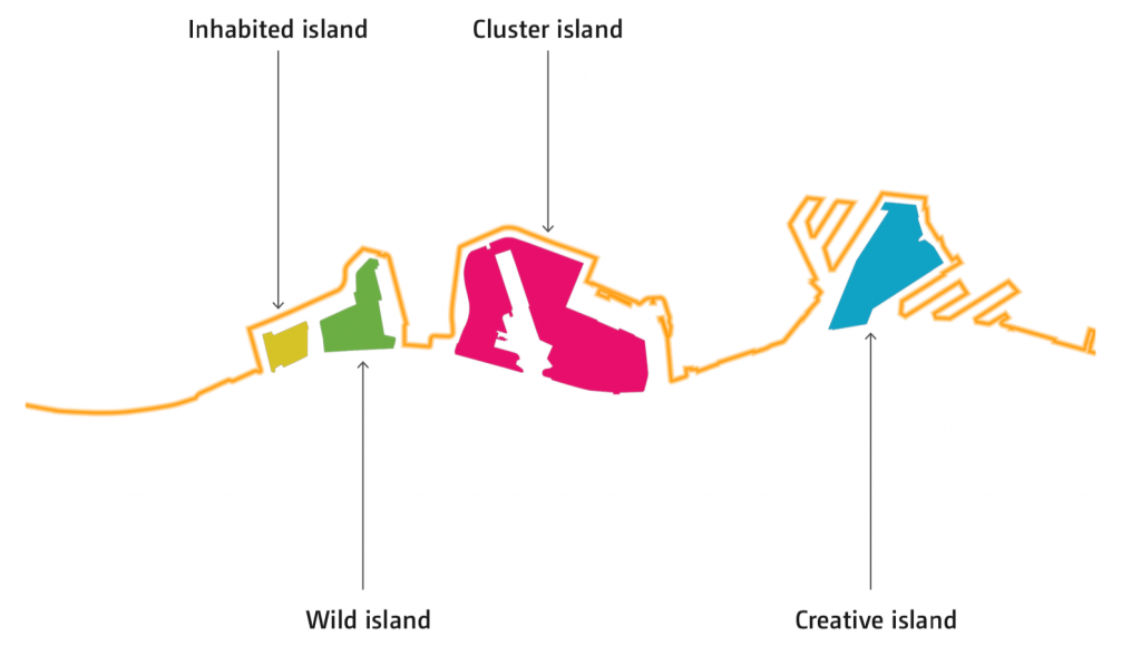
Islands | spaces resilient to different economic scenarios
The islands are spatially defined areas where scenarios can unfold over time. Although their shape is fixed, in order to assure a new beneficial relationship between port and city, their program – be it maritime, commercial, residential or recreational – can occupy the space according to future economic trends, needs and decisions.
Mobility)
Parravicini, Noha, Move Mobility).
A proactive approach | planning is not a consequence
Port Vision 2030 [4], instead, a framework fixes main ‘quality principles’, which are guided by a primary spatial strategy that aims to prioritize the livability if the city. The scenarios are not 4 separate options, rather, scenarios can coexist with different weight. A framework fixes the main ‘quality principles’, which are guided by a primary spatial strategy that aims to create high quality urban space and allows scenarios to develop flexibly.
The diffuse campus | trading, making, learning, researching, living, recreating
Starting from the idea of ‘making over trading’, we can elaborate on ideas for programmatic diversity to meet our ‘themes’, for instance learning, living, and recreating. Those topics are tied together by the common spatial framework of a continuous accessible waterfront that defines new relations with the Maas. The key is to relate the main maritime companies and supporting companies to cultural and educational institutions for the mutual benefit of the maritime cluster and the city. To achieve those objectives it is necessary a shifting of paradigm in terms of spatial transformation and asset balance, where human scale and ecology gains a central role; without neglecting the industrial/logistic role of port areas, a more virtuous cohexistence is possible.
(© Openfabric in collaboration with KartonKraft, Mauro Parravicini, Noha, Move Mobility).
Head Image | Port of Rotterdam. (©JGF|ph. Jacopo Gennari Feslikenian).
Notes
[1] The Research by Design project “Archipelago of Knowledge. A diffuse Campus” was commissioned by Deltametropool (Research Coordinator) and Uenl (Coordinator) in collaboration with Province South-Holland, Regio Drechtsteden, MRDH, Regio Alblasserwaard-Vijfheerenlanden, Gemeente Rotterdam.
It was developed by a multidisciplinary team lead by Openfabric (Francesco Garofalo, Jacopo Gennari Feslikenian, Matteo Motti, Garrett Craig-Lucas, Laura Lopez Iglesias) in collaboration with Kartonkraft (Marta M. Roy Torrecilla), Mauro Parravicini, Noha (Kai Van Hasselt), Move Mobility (Marcen Van Lieshout).
[2] B. Kuipers, M. Streng, W. Manshanden & O. Koops (2017), Scenarios for the maritime cluster in Zuid-Holland and Werkendam. Background study ‘Prospective Survey of the Maritime Cluster in Zuid-Holland’, Rotterdam; Erasmus UPT & NEO.
[3] De Martino, Paolo. “Land in limbo: understanding Planning Agencies and Spatial Development at the Interface of the Port and City of Naples”, in Carola Hein (ed.) International Planning History Society Proceedings, 17th IPHS Conference, History-Urbanism-Resilience, TU Delft 17-21 July 2016, V.03 p.203, TU Delft Open, 2016.
[4] Port Vision 2030 (Port Compass by Port of Rotterdam Authority)
https://www.portofrotterdam.com/sites/default/files/2021-06/port%20vision.pdf/.