╔
Dinamiche del territorio. Nature Based Solutions – Nuove definizioni di millenarie buone pratiche
L’impatto dell’Etna: il paesaggio in continua evoluzione di Catania
Etna’s Impact: Catania’s Ever-Changing Landscape
Catania sorge alle pendici del vulcano Etna e la sua morfologia, i suoi colori, la sua storia, sviluppo ed economia dipendono dall’attività eruttiva Etna. Le colate laviche etnee più volte sono arrivate in città e ciclicamente ne hanno cambiato la geografia modificandone la costa, distruggendo e creando porzioni di territorio: come le lave del Rotolo che giunte al mare nei pressi di Ognina hanno ridotto a piccolo golfo quello che era il grandissimo porto della città in epoca romana; come le lave del 1669 che hanno creato la porzione di città su cui attualmente si trova il quartiere San Cristoforo ridisegnando il nuovo golfo che ospita l’attuale porto.
Anche i sismi, sebbene non unicamente associabili all’attività etnea [1], sono stati determinanti nello sviluppo della città, alternando periodi di splendore e ricchezza a periodi di declino in corrispondenza del loro verificarsi.
Catania is located at the foot of Etna Volcano with its landscape, history, colors, and economic fortunes intricately linked to the volcano’s activity. Over time, Etna’s lava flows have repeatedly reached the city, reshaping its geography by modifying coastlines and transforming landforms. For example, the Rotolo lava filled the Gulf of Ognina, reducing the city’s once-grand Roman port to a small bay. Similarly, the lava flows of 1669 formed the new land of the present San Cristoforo district and reshaped the coastline to host Catania’s modern port.
In addition to lava, earthquakes – though not exclusively linked to Etna [1] – have significantly influenced Catania’s development, by determining periods of growth to periods of decline as result of the occurrence of natural catastrophes.
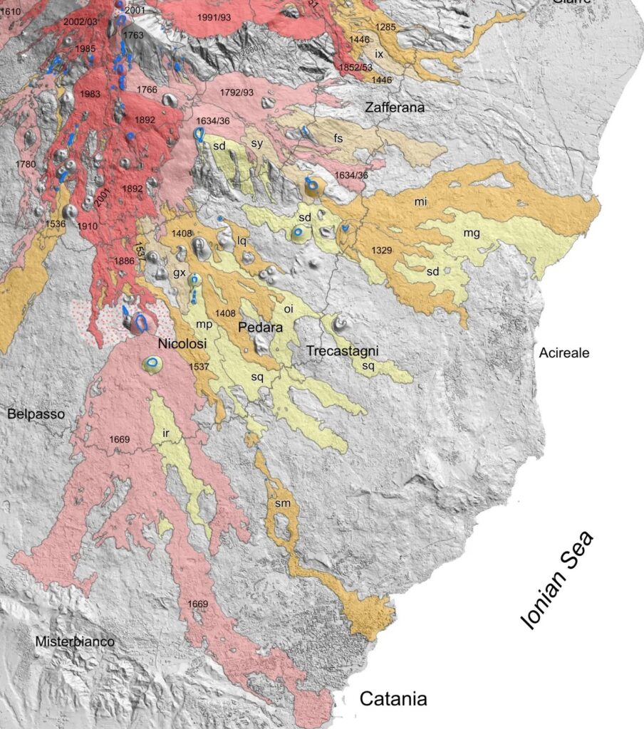
Mappa geologica dell’Etna da cui è possibile prendere visione degli effetti delle eruzioni e delle colate laviche sulla città di Catania e sul suo waterfront. (Fonte: Elaborazione da https://www.meteoweb.eu/2021/01/eruzioni-epoca-storica-etna/1536791/).
Geological map of Etna from which it is possible to view the effects of eruptions and lava flows on the city of Catania and its waterfront. (Source: Elaboration by https://www.meteoweb.eu/2021/01/eruzioni-epoca-storica-etna/1536791/).
Basta fare una passeggiata per la città per avere evidenza di questo territorio in costante evoluzione: si passa infatti da aree pianeggianti a bruschi cambi di pendenza dovuti sia alla messa in posto delle colate sia all’accumulo di rovine di case distrutti dai terremoti. E sebbene la città che si visita è la città barocca, non è raro trovare punti in cui a due/tre piani sottoterra emergono la città romana come al Monastero dei Benedettini, o il teatro di piazza Stesicoro e ancora il Castello Ursino che era stato edificato come roccaforte al mare (ora al centro città), i cui torrioni sono stati dissepolti dalla colata qualche anno fa.
Persino dell’originaria idrografia superficiale, rimane ben poco visibile a noi, si trova oggi in gran parte sepolta sotto strati di lava e/o le altre rovine del terremoto. Fiumi come l’Amenano e il Longane, famosissimi per i catanesi, scorrono sotterraneamente lungo cavità, vecchi condotti lavici e persino vecchie fognature. E ancora il Lago di Nicito: lago scomparso in una sola notte risucchiato probabilmente dall’apertura di una cavità.
Sebbene le colate laviche descritte non abbiano interessato l’area dove sorge l’attuale porto della città, ne hanno comunque influenzato la sviluppo. La colata (1669) ha ridefinito il Golfo rendendolo più chiuso morfologicamente, e quindi meno soggetto all’azione distruttiva di correnti e mareggiate (più volte a cavallo tra il XV e XXIX sec. la storia ne ha riportato la distruzione). Insieme alla lava, pochi anni dopo, il terremoto (1693 – offre infiniti metri cubi di materiale di riporto) e l’ambizioso inizio del periodo borbonico (1734) sono i 3 elementi che concorrono alla ricostruzione del porto, secondo moderne tecniche costruttive, prestando attenzione alla robustezza della strutture e cominciando la costruzione della diga foranea.
Tuttavia (e mi dispiace deludere i lettori), l’affermazione del porto della città come porto importante della Sicilia orientale avviene solo intorno agli anni ’10 del secolo scorso, determinato da un’altra devastante catastrofe naturale, ovvero il terribile terremoto che in una fredda mattina di dicembre del 1908 rade al suolo Messina spazzando via per sempre il millenario porto che fu greco/romano/angioino/asburgico/borbonico/ etc… della città.
A walk through the city reveals visible evidence of these this constantly changing territory: flat areas suddenly give way to steep slopes, a result of both lava deposition and the accumulation of earthquake-damaged structures. While much of the visible cityscape reflects the Baroque era, it’s not uncommon to discover Roman and medieval structures emerging two or three floors below ground level (for example in the Benedictine Monastery, the theatre in piazza Stesicoro), and remarkably, the Ursino Castle, originally constructed as a coastal fortress the castle’s towers were uncovered from beneath a lava flow just a few years ago.
Even the city’s original hydrographic network is now largely hidden and buried beneath layers of lava and/or rest of the earthquakes ruins. Rivers like the Amenano and Longane, once integral to Catania’s identity, now flow underground through cavity, ancient lava tubes and sewers. Similarly, Lake Nicito, disappeared overnight, probably due to a cavity opening.
Although the described lava flows did not affect the area where the city’s current port stands, they indirectly influenced its development. In fact, the lava flow (1669) redefined the Gulf, making it more morphologically closed and thus less subject to the destructive action of currents and storm surges (several times at the turn of the 15th and 19th centuries history reported its destruction). Together with the lava, a few years after the earthquake (1693 – offers endless cubic meters of landfill material) and then the ambitious beginning of the Borbonic period (1734) are the 3 elements that contribute to the reconstruction of the harbor in the closer (similar) version to how we know it now (refilling also with landfill material the construction of the breakwater).
However (and I am sorry to let you down), the affirmation of the city’s port as an important port of eastern Sicily occurs only around the 1910s, following (due/thanks) the terrible earthquake that on a cold December morning in 1908 razed Messina to the ground, wiping out forever the millennial port that was Greek/Roman/Angevin/Habsburg/Bourbon/etc.
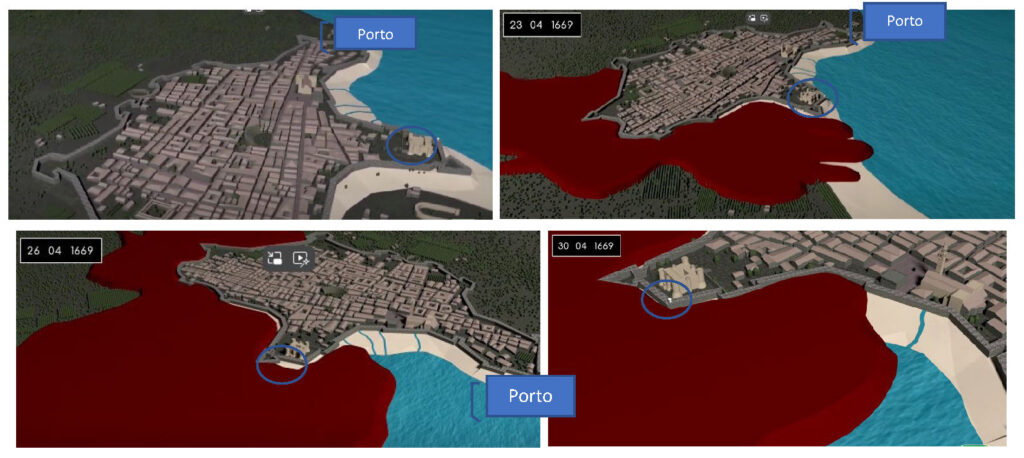
Le aree della città interessate dalle colate laviche del 1669. (Fonte: Screenshot del video realizzato da ETNA 1669 – Luoghi e conseguenze (documentario eruzione – seconda parte) a cura di Antonio De Luca).
The areas areas of Catania affected by the lava flows in the 1669. (Source: Screenshot of the video made by ETNA 1669 – Places and consequences (eruption documentary – second part) edited by Antonio De Luca).
Alla più o meno consapevolezza dei rischi di vivere in un’area vulcanico-sismica sono associate anche grandi opportunità: la fertilità dei terreni, i numerosi e differenti prodotti vulcanici che sin da tempi antichi offrono materiali da costruzione e hanno favorito lo sviluppo di attività produttive (estrazione, lavorazione e trasformazione), uniti nel caso specifico della città di Catania alla vicinanza al mare [2].
Risulta chiaro che un contesto così ricco e dinamico, è una palestra ideale per pianificare, implementare, monitorare e valutare gli impatti delle iniziative NBS (Nature Based Solutions), e per altrettante misure di mitigazione dei numerosi rischi quali l’attività vulcanica, i terremoti e dinamiche costiere.
Associated with the more or less awareness of the risks of living in a volcanic-earthquake area are also great opportunities: the fertility of the soils, the many different volcanic products that since ancient times have offered building materials and developed productive activities of mining, processing and transformation, joined in the specific case of the city of Catania to the proximity to the sea [2].
It’s evident that such a fast and dynamic context, where geology transitions into history, serves as an ideal training ground for planning, implementing, monitoring, and assessing the impacts of Nature Based Solutions (NBS) initiatives, and for testing multiple initiatives aimed at mitigating various risks and multiple hazard such as volcanic activity, earthquakes, even coastal dynamics.
Cosa sono le Nature Based Solutions
Nature Based Solutions: A Definition
Partendo dalla definizione della UE, le soluzioni basate sulla natura (NBS) mirano ad affrontare le sfide ambientali e sociali utilizzando o imitando i processi naturali.
Raggruppate sotto il cappello NBS, troviamo le pratiche ambientali ovviamente sostenibili e di “long term impact” ormai suggerite da tutti i piani strategici come mezzo per raggiungere gli acclamati “OBIETTIVI ambientali” [3]. Le NBS sono quindi elementi chiave dei Green Deal, dei documenti politici strategici sul cambiamento climatico e sulla biodiversità, dell’economia verde e blu; sempre più presenti nei programmi di ricerca e innovazione; oltre che parte integrante delle strategie di riduzione del rischio di catastrofi [4], che enfatizzano l’aumento dei servizi ecosistemici in ambito urbano, rurale, costiero e naturale come “approccio positivo, efficace e a costi ridotti”.
Sebbene molti termini associati alle NBS sono entrati nell’uso comune spesso sono utilizzati solo come traduzione letterale. È d’obbligo ricordare che dietro ognuno di questi termini ci sono concetti, buone pratiche (moderne e millenarie), studi e analisi sviluppati in 20 anni di convenzioni internazionali [5], e conseguenti protocolli, accordi, roadmap [6]; lotte ambientaliste e meccanismi di finanziamento mondiali [7].
According to European Union’s definition, Nature Based Solutions (NBS) aim to address global challenges by either utilizing or emulating natural processes.
Grouped under the NBS umbrella, we find the obviously sustainable and ‘long term impact’ environmental practices now suggested by all strategic and action plans as a means to achieve the praised “environmental GOALS” [3]. So, NBS are key elements of the Green Deal, of the strategic policy documents on climate change and biodiversity strategies, green and blue economy; increasingly mainstreamed in research and innovation programs; and are also integral into disaster risk reduction strategies [4], emphasizing the augmentation of ecosystem services across urban, rural, coastal, and natural domains as a “positive, effective, and cost-reduced approach”.
NBS terms have become commonplace, often being used quite literally. However, it’s essential to remember that behind each of these terms lie concepts, best practices (ancient and modern), studies and analyses developed in two decades of international conventions [5], COPs and resulting protocols, agreements, roadmaps [6]; environmental activism, global funding mechanisms [7].
Antica saggezza negli approcci basati sulla natura
Ancient Wisdom in Nature Based Approaches
Quanto c’è di nuovo nelle NBS? Esempi di Nature Based Solution sono praticati nel territorio etneo in agricoltura sin da tempi antichissimi. Già circa 1000 anni fa, gli arabi che praticavano in Sicilia una vera e propria “smart agricolture” con tanto di “sustainable water management”. Agli arabi si deve l’introduzione di sofisticate soluzioni tecniche per la gestione dell’acqua sostenibili e adeguate al clima mediterraneo dell’isola, come le “Saie”: piccole aree di ristagno che evitano il rapido deflusso e combattono lo spreco; come l’uso dei terrazzamenti: soluzioni “fondamentali” per i paesaggi accidentati etnei che aiutano sia a trattenere l’acqua sia a ridurre l’erosione del suolo; come la rotazione delle colture: ancora oggi soluzione più accreditata per arrestare la perdita della biodiversità in molte aree del mondo ormai devastate dalle monocolture intensive.
Oltre le soluzioni tecniche introdussero anche modelli di gestione partecipativa: ovvero un approccio alla distribuzione dell’acqua gestito dalla comunità precursore degli attuali modelli di governance partecipativa, soluzione a cui, oggi, fanno l’occhiolino molti programmi ambientali.
Queste antiche pratiche se valutate alla luce dei moderni standard UE, risulterebbero a impatto ambientale nullo (o quasi) per le loro indiscusse caratteristiche di sostenibilità (ovvero sostenere la produzione agricola senza sfruttare le risorse), resilienza (terrazzamenti e saie esistono ancora oggi) e conservazione degli ecosistemi (nella rotazione delle colture), oltre che allinearsi con i moderni modelli di governance che enfatizzano il coinvolgimento della comunità.
Altre NBS si ritrovano nell’uso della pietra lavica nell’”architettura” tradizionale sia in ambiente urbano che rurale. Tutto il centro storico è stato costruito con resti di vecchi edifici distrutti dal terremoto, misti a grossi blocchi di lava utilizzati uno sopra l’altro sfruttandone la naturale scabrosità. Tecnica largamente utilizzata nei muretti a secco che caratterizzano il paesaggio rurale ed etneo. Anche in questo caso, una valutazione dell’impatto ambientale (e persino un LCA – Life Cicle Assesment) darebbe ottimi risultati per le intrinseche caratteristiche di durabilità, longevità e resistenza del materiale lavico, senza emissioni di carbonio legate al trasporto.
Sebbene le prestazioni sismiche potrebbero non essere perfettamente allineate con le moderne normative sismiche, nulla vieta di migliorare queste soluzioni alla luce delle conoscenze attuali.
Are NBS modern practices? In the Etna territory, Nature Based Solutions have been implemented in agriculture since ancient times. Almost 1000 years ago, the Arabs practiced sophisticated “smart agriculture” in Sicily, incorporating the true “sustainable water management” techniques. They introduced advanced solutions tailored to the island’s Mediterranean climate, such as the so-called “Saie” – small reservoir areas that mitigate rapid runoff and combat waste. Other practices included the use of terraces, crucial for the rugged landscapes of Mount Etna, aiding in water retention and soil erosion prevention. Crop rotation was also employed, recognized today as the most effective method to counteract biodiversity loss caused by intensive monocultures.
Furthermore, the Arabs introduced “community-based water management”, a forerunner to modern participatory water governance models. This approach empowered communities to manage water distribution, and is now embraced by environmental programs worldwide.
These ancient water management techniques in agriculture would now demonstrate negligible environmental impact, if assessed in accordance with the latest European standards, due to their undisputed characteristics of sustainability and resilience. Sustainability in facilitating agricultural production (without exploiting resource), resilience in terraces and “Saie” still endure today, and promoting and ecosystem conservation in crop rotation and smart agriculture practices; as well as aligning with contemporary participatory governance models emphasizing community engagement.
Further examples of Nature Based Solutions are evident in the use of lava stones both in urban and rural traditional “architecture”. The present-day historic center of the city incorporates remnants of ancient buildings razed by the earthquake, intertwined with sizable lava blocks stacked layer upon layer (using their natural roughness) as well as in rural areas the same overlapping technique, characterizing the neighboring landscapes. Even in this context, an Environmental Impact Assessment (or even LCA Life Cycle Assessment) conducted through a modern EU lens would underscore their durability, longevity, and weather resistance, beyond a 0 footprint due to NO transport-related carbon emissions.
Although the seismic performance may not perfectly conform to current seismic regulations, there is ample scope for reassessment and enhancement this solutions in light of current knowledge.
Verso un futuro più verde: sfide e speranze per lo sviluppo di Catania
Towards a Greener Future: Challenges and Hopes for Catania’s Development
A Catania (e non solo!), le antiche pratiche virtuose sono state in gran parte abbandonate negli ultimi cinquant’anni a favore di uno sviluppo incontrollato e violento, segnato da cementificazione senza nessuna traccia di pianificazione territoriale, e contraddistinto da un consumo di suolo folle e senza precedenti per la rapidità con cui si è verificato. La realtà attuale è quella di una città soggetta a inondazioni (in caso di forti piogge), di un’area costiera soggetta a erosione e degrado a causa delle attività umane, di un paesaggio urbano densamente urbanizzato e cementificato, evidentemente non adatto, in quanto privo di spazi aperti, vie di fuga, aree vuote, a garantire la sicurezza pubblica in un area ad alto rischio sismico e vulcanico. Il catalogo delle pratiche insostenibili in tutti i sensi è lungo, con impatti ambientali significativi che si traducono in costi sempre più alti per la collettività.
Ma ripartendo dai concetti chiave che si celano dietro le NBS quali rispetto, equilibrio (uomo ambiente) sostenibilità e durabilità nel lungo termine, si potrebbe dare vita a un’infinita gamma di iniziative NBS proprio in questa città (dal ricco e dinamico contesto naturale)? E se il futuro che si legge nei documenti programmatici fosse veramente possibile?
In Catania (and not just there!), ancient virtuous practices have largely been forsaken/abandoned over the past fifty years in favor of uncontrolled and violent development, marked by rampant cementing without any idea of land use planning, marked by insane land consumption without precedent for the rapidity with which it has occurred. The present reality is a city susceptible to flooding (during the heavy rainfall event), a city’s coastal areas facing erosion and degradation due to human activities, join to a densely urbanized and cemented cityscape lacking in crucial open spaces clearly unfit to cope (which is evidently ill-equipped) as it lacks open spaces, escape routes, empty areas, crucial to ensure public safety in an high seismic and volcanic risk area. More, the catalog of unsustainable practices is long, with significant environmental impacts resulting in very high costs to the community.
Yet, by returning key concepts behind NBS such as respect for the environment, balance (human-environment) sustainability, and resilient, it could be possible to implement a wide array of NBS initiatives in this city, owing to its rich and dynamic natural environment. What if the vision for the future outlined in policy documents could actually become a reality?
IMMAGINE INIZIALE | Il Porto Antico di Catania e il vulcano Etna sullo sfondo. (Foto: Elena Cocuzza).
HEAD IMAGE | The Old Port Catania and the Etna volcan in the background. (Photo: Elena Cocuzza).
╝
NOTE
NOTES
[1] Catania si trova in un attivo contesto geodinamico, al bordo della placca Africana e della placca euroasiatica. Questa intersezione ha dato origine alla struttura vulcanica del Monte Etna, rendendo Catania vulnerabile all’attività sismica sia dell’Etna che della regione Iblea.
[2] I terreni vulcanici intorno a Catania, ricchi di minerali e sostanze nutritive, sono altamente fertili. Caratteristiche già note ai greci e ai romani che proprio sotto il vulcano decisero di fondare le loro città.
[3] Elencati negli SDGs (Obiettivi di Sviluppo Sostenibili) in attuazione Accordi di Parigi (2015) e dell’agenda 2030.
[4] Sendai Framework for Disaster Risk Reduction 2015-2030.
[5] UNFCCC: United Nations Framework Convention on Climate Change, UNCCD: United Nations Convention to Combat Desertification, Ramsar: Ramsar Convention on Wetlands.
[6] COP come Conference of the Parties (organi supremi delle convenzioni) con i suoi organi di governo, CMD Clean Development Mechanism come organo di governo del Protocollo di Kyoto, CDA come organo di governo degli Accordi di Parigi.
[7] Dal CDM Clean Development Mechanism (il primo programma globale di investimenti e crediti ambientali), GEF Global Environment Facility – GCF Green Climate Fund, AF – Adaptation Fund etc.
[1] Catania is situated within an active geodynamic setting, marked by the structural interaction between the African Plate and the transitional zone of the Eurasian Plate. This intersection gave rise to the volcanic edifice of Mount Etna, making Catania vulnerable to seismic activity from both Etna and the Iblean region.
[2] The volcanic soils surrounding Catania, enriched with minerals and nutrients, are renowned for their fertility. Those characteristics was well-known to the Greeks and Romans, who established their cities beneath the volcano.
[3] Listed in SDGs Sustainable Development Goals – Paris Agreement (2015) and agenda 2030.
[4] (Sendai Framework for Disaster Risk Reduction 2015-2030).
[5] UNFCCC: United Nations Framework Convention on Climate Change, UNCCD: United Nations Convention to Combat Desertification, Ramsar: Ramsar Convention on Wetlands.
[6] COP as Conference of the Parties (supreme bodies of the conventions) with its governing bodies, CMD Clean Development Mechanism as governing body of the Kyoto Protocol, CDA as governing body of the Paris Agreements.
[7] From CDM Clean Development Mechanism (the first global, environmental investment and credit scheme), GEF Global Environment Facility – GCF Green Climate Fund, AF – adaptation fund etc.