╔
Port areas may be sites of industrial production, however any resulting air pollution is not confined by port borders. Plans for ports therefore need to consider land use in nearby areas and the structure of those areas. Planning must strive for a meaningful balance between the advantages and disadvantages of having a port within a territory. To understand and address the challenges of flows linked to port activities requires careful understanding of geographical, morphological, industrial, social, and other characteristics in relation to localities and global flows. For example, when we examine the case of the port of Rotterdam and its territory through the lens of wind and air pollution, we see that the maritime corridors in the channel and on the North Sea produce a lot of air pollution. The internet site windy.com depicts open data from the European Commission’s Copernicus program [2] and shows, for example, the NO2 emissions created both on sea and in industrial areas.
Air pollution from sea and land, generated by maritime traffic, combines with wind flows and diffuses into nearby cities such as Delft, The Hague, Dordrecht, and surrounding territories. NO2 is bad for the health of humans; it also ends up in the ground and causes eutrophication—excessive nutrient supply. High levels of NO2 are an environmental and political issue in the Netherlands, where manure from hog and cattle farming and the burning of fossil fuels for energy and mobility generate large amounts of NO2. Motorists and farmers are pitted against each other and while fewer pigs, cows, and fossil-fuel powered vehicles could help solve the crisis, each solution puts demands on a specific population group. The crisis has also impacted the construction industry, which also generates NO2, and requires a permit in line with government policies [3].
Any assessment of the positive and negative externalities of living in the vicinity of a port needs to acknowledge multiple data points. Air pollution, such as NO2, which can reduce life expectancy, is not positive, yet it may be balanced by higher income or access to higher education or food. Research in and around Rotterdam shows surprising differences between life expectancy in the small village of Pernis and in Rotterdam South. In Pernis, despite its proximity to major refineries, life expectancy is relatively high, possibly due to the fact that more highly paid engineers traditionally lived there. Rotterdam South, meanwhile, is closer to the center of the city and has been home to various migrant communities.
To better capture the concept of the port city territory as the place where port-related flows shape spaces on sea and land, I have proposed the notion of the port cityscape [4]. Such an approach is important as it allows us to understand how areas that are far away from a port, such as dry ports, can have an impact on spatial development. For example, the economic value of logistics and the rapid passage of trucks through a neighborhood is very different from the local value of livability, a logistics of care, or of children playing [5]. The dualities that result from diverging interests are exemplified in the following figure. In many ways, this image represents a translation of shared challenges with different values into the physical reality of the territory. Understanding the existence of different values beyond economics and balancing them is key to developing and implementing new approaches to port city symbiosis, as discussed in a special issue of Maritime Economics and Logistics [6].
Port City Futures: Dualities of interests in port city territories.
To address challenges that result from conflicting interests and needs, such as the one of pollution in port city territories, we need to adopt ecosystem approaches that go beyond existing governance borders and other conceptual lines of separation, such as between land and water. To achieve this, we need to reconceptualize the port city territory as a key player, a key location, and as a potential steward of water futures. In the Port City Atlas [7] published in 2023, we argue that naming and conceptualizing the port city territory – its form, governance, and culture – as unique is an important first step to establishing an ecosystem approach. Developing methods to visualize the multiple flows, institutions, and practices that occur in these territories requires new conceptual and methodological approaches. The Port City Atlas demonstrates that the visualization of quantitative and qualitative data in maps and infographics can provide a foundation for comparative analysis going beyond case study approaches that are often locked in to national contexts, particular languages, and disciplinary approaches.
Exploring the system of Spanish port city territories included in the Port City Atlas, for example, reveals opportunities and challenges. The Atlas includes fourteen Spanish port city territories, eight on the Atlantic Sea—including on the northern (Bilbao, Gijon, A Coruna, Ferrol) and southern coasts (Huelva, Cadiz) of Spain, and on the islands (Las Palmas, Santa Cruz de Tenerife), as well as the six port city territories in the Mediterranean (Algeciras, Ceuta, Cartagena, Valencia, Castellon, Tarragona, Barcelona). Except for the island ports, all the Spanish ports are some 300–500 km from the landlocked capital Madrid, where 6,8 million of the 47,5 million Spaniards live. The ports are thus key to facilitating the distribution of goods to the capital and reveals the spatial structure of Spain. The governance of these port city territories and the challenges they pose on urban environments and fragile natural sites need to be understood in relation to the capital city where decisions are taken and The challenges of planning for port city territories and across administrative units are particularly evident when considering the ports of Algeciras and Ceuta, which function as a port city territory across the Strait of Gibraltar, crossing two continents.
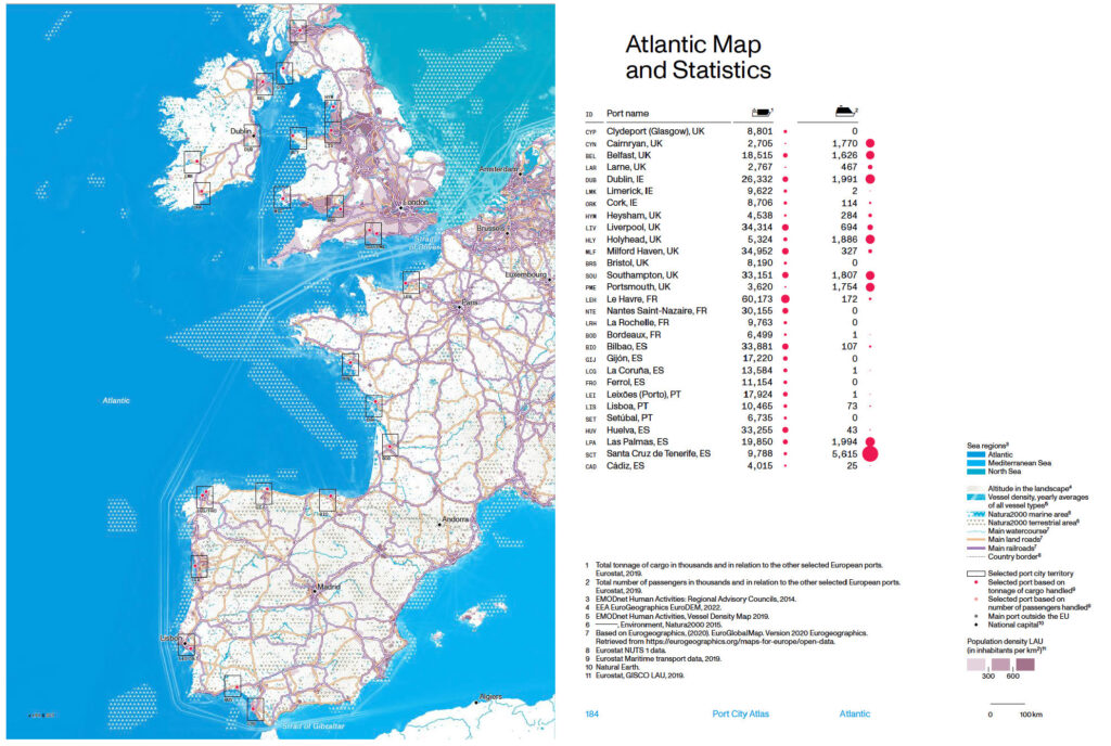
Spanish port city territories on the coast of the Atlantic. (Source: The Port City Atlas, 2023).
The Spanish port city territories are diverse in terms of hinterland access, with several of them being close to mountain ranges in the hinterland, or, located in wetlands. Many ports are close to population centers, where industrial pollution can affect the quality of life for nearby populations and where port extension projects compete with the interests of people who live in the vicinity. Mapping can thus help identify areas in which one may expect opposition groups to emerge. Understanding how different types of ports relate to specific locations—including fragile ones—, such as those located on estuaries, rivers, coasts, and those near lagoons, wetlands, and Natura 2000 sites, raises issues of mobility and hinterland access as well as the protection of conservation sites.
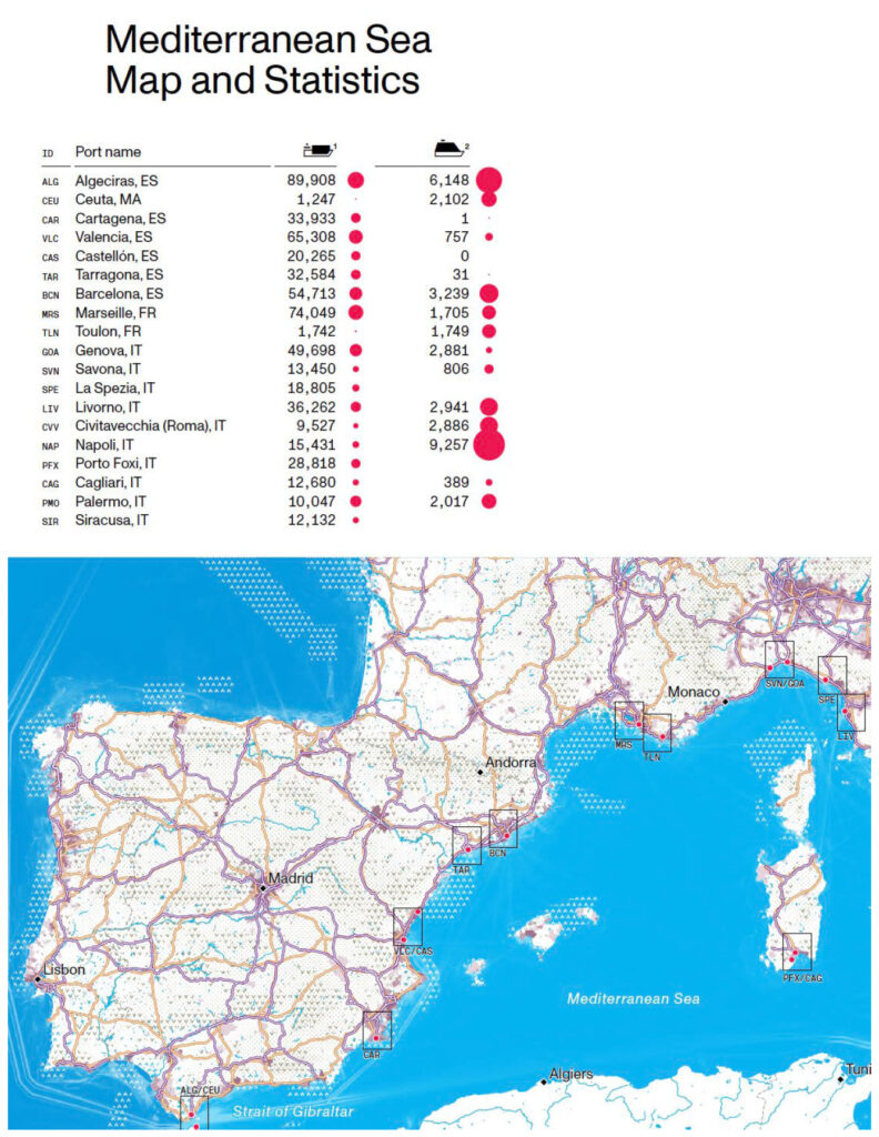
Port city territories on the Mediterranean Sea. (Source: The Port City Atlas, 2023).
One example of both shared challenges and opportunities in port city territories at a time of multiple urgencies is the presence of important UNESCO World Heritage properties in many of the leading Spanish port city territories. These heritage sites are very diverse, including natural and cultural sites. They are not all of directly related to water or shipping, yet together they tell a story of technological innovation, of maritime engagement and trade, and of cultural innovation. They are also facing water-related challenges where port activities and maritime knowledge can provide innovative support. A Coruna, for example, is home to the Tower of Hercules, a Roman lighthouse “still used for maritime signaling” that stands as a “testimony to the elaborate system of navigation in antiquity and it provides an understanding of the Atlantic sea route in Western Europe” [8]. Such a site can help create awareness of changing coastlines at a time of sea-level rise and possibly inspire new coastal approaches. Valencia hosts the Lonja de la Seda de Valencia (Silk Exchange) a group of buildings used for silk trading and a center of commerce with the Gothic Sala de Contratación (Contract Hall or Trading Hall) that speaks to the historic power and wealth of this Mediterranean maritime center in the 15th and 16th centuries [9]. This history of creativity and innovation is needed for the future. Not all port city territories are home to water- or maritime-related World Heritage sites, but the heritage sites will require new approaches to water-related changes.
The comprehensive, mapping-based approach of the Port City Atlas aims to provide shared spatial information for the exploration of a single port city territory as part of a larger system of maritime and transport connections, and for standardized comparison among multiple territories. Mapping can help can facilitate the identification of “gaps” [10], where spatial, institutional or cultural opportunities and challenges exist, and where planning can be of benefit. It also affords local decision-makers with novel insights regarding the complex territories at the boundary between sea and land. Translating the insights into new planning and governance approaches requires collaboration among diverse actors and a desire to collaborate in action supporting shared values.
IMAGEN INICIAL | A comparative mapping of port city territories in Mediterranean Sea. (Source: The Port City Atlas, 2023).
╝
NOTES
[1] Carola Hein, Yvonne van Mil, and Lucija Azman-Momirski, Port City Atlas, TU Delft/nai010, 2023; Book review of Port City Atlas, Portus 45 (2023). https://portusonline.org/port-city-atlas-mapping-european-port-city-territories-from-understanding-to-design/.
[2]https://www.esa.int/Applications/Observing_the_Earth/Copernicus/Europe_s_Copernicus_programme/.
[3] What’s all the fuss about Nitrogene in the Netherlands? June 5 2022, Dutch News, https://www.dutchnews.nl/2022/06/whats-all-the-fuss-about-nitrogen-in-the-netherlands/.
[4] Carola Hein, “The PortCityScape: Spatial and Institutional Approaches to City Relationships,” PortusPlus 8 (2019). https://portusplus.org/index.php/pp/article/view/190/.
[5] Carola Hein, “Port City Futures,” Portus (Nov. 2018). https://portusonline.org/port-city-futures/.
[6] Maurice Jansen and Carola Hein. “Port City Symbiosis: Introduction to the Special Issue”, Maritime Economics and Logistics 25(2023): 211–29. https://doi.org/10.1057/s41278-023-00257-x/.
[7] Carola Hein, Yvonne van Mil, and Lucija Azman-Momirski (2023), Port City Atlas, nai010 publishers.
[8] UNESCO, Tower of Hercules, https://whc.unesco.org/en/list/1312/.
[9] UNESCO, La Lonja de la Seda de Valencia, https://whc.unesco.org/en/list/782/.
[10] Carola Hein and Yvonne von Mil, “Mapping as Gap-Finder: Geddes, Tyrwhitt, and the Comparative Spatial Analysis of Port City Regions,” Urban Planning, 5, no. 2 (2020): 152–66. https://doi.org/10.17645/up.v5i2.2803/.