Especially port cities have demonstrated in the past the capability to prepare for, to respond to, and recover from significant threats. Through history, natural or human-made disasters as well as external political or economical transformations have (re-)shaped the spatial structure of port cities. In history the perspective of adaptive, comprehensive projection was often generally included, while the term resilience was often integrated but not explicitly mentioned. Port cities also have a long history as nodes in global economic networks; they also have a long history of resilience. Throughout history, natural or human-made disasters as well as political, economic or geographic transformations have (re)-shaped shipping patterns, ports and waterfronts as well as the urban fabric, and port cities have demonstrated a unique capacity to deal with a broad range of external shocks. Is the actual increased significance in smart and resilient cities a marketing-driven hype, or does it include an integrative relevant perspective for seaport cities?
In Hamburg irreversible decisions from the 18th century for a tidal seaport, the construction of the Warehouse District and relocation of over 20.000 inhabitants, the Cholera Epidemic 1892 with over 6.000 victims and the following slum clearance, the flood in 1962 with over 300 dead, as well as the container revolution in cargo handling and the opening of eastern Europe and Russia for trade after 1989, demonstrate an ability to react on challenges in a flexible, foresighted way.
The competitiveness of Hamburg as a seaport city gains more influence and some of the challenges can only be dealt with on a regional level (like dredging of the river Elbe), some of them on a national and some of them only on a global level. Expected but unpredictable impacts of climate change, such as rising sea levels and periods of precipitation and more intensive rainfall, an increasing tidal range and flooding from inland are just some of the challenges for vulnerable seaport city.
The most important aim of the guiding Hamburg plan “Spatial Vision” (2007) reads “More city in the city”. With this demand Hamburg gives consistently the priority to higher densities, infill and sustainable spatial redevelopment. The usage of often precious scenic and natural open space is minimized. The “Green Metropolis on the Waterfront” is and will be an important feature of Hamburg and a benchmark for the redevelopment. To those belong especially businesses of the competence cluster “port and logistics” as well as “aviation”, which are supported by various promotions. But as Hamburg is one of the few seaports with port facilities next to the city centre, this requires compromises and a responsible and sustainable use of space and resources, a balance of spatial requirements as well a cooperation of stakeholders from city and port. Hamburg Port Authority (HPA) is developing a complementary smartPort strategy as an intelligent hub for sustainable growth, to optimize the benefits for clients, while minimising environmental effects [1]. Smart implies an integrative approach, with dimensions like sustainable, mobile, accountability, resilience and technology.
As Hamburg faces severe challenges of flooding, these perspectives include a paradigm shift from “predict-and-control” to “integrated-adaptive” strategies, including before, during and after flooding as well as new forms of participatory flood risk management. But responsibilities for flood risk management and urban planning are still fragmented [2].
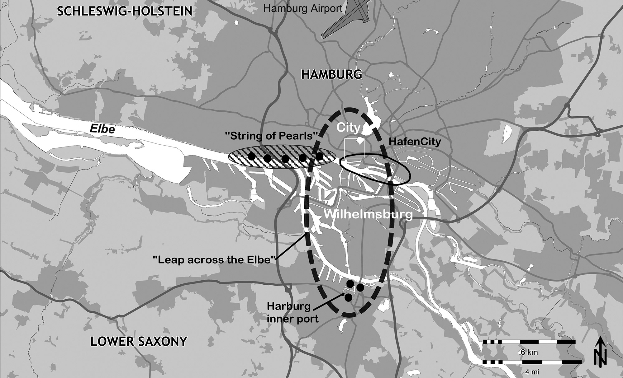
Beginnings of Redevelopment: “String of Pearls”
The waterfront along the northern shore of the Elbe in Altona, with splendid views towards the shipyards and ocean liners, plays a special role in Hamburg. Like in other seaport cities, the oldest facilities and infrastructures from the mid-nineteenth century near the city centre became vacant or underused in the 1980s and the port moved seawards where new container terminals were built. When its port-related activities declined, public attention became increasingly focused on new uses. In the early 1980s, the northern shore of the Elbe comprised a heterogeneous mix of land uses with buildings from the mid-nineteenth century to the post-war period. A catchy name was found for the zone: “String of Pearls”. It was assumed that applying a coherent strategy for the whole area would be difficult, but that a string of spectacular projects based on a market-led approach would generate enough interest and, consequently, higher land values to upgrade the area. For flood protection several buildings were included into a polder, which provided protection from flooding [3].
Since then, a number of new buildings and conversions of older warehouses have significantly gentrified the area along the northern Elbe bank. The long periods of time that pass from riverfront sites falling derelict to surveys, designs and implementation works, are due to different reasons specific to each project. The implementation of projects was not strictly governed by planning requirements, but by the availability of plots and developers’ interests as well as investment considerations that originated from different periods and planning contexts. The metaphor of the “string of pearls” suggests that there had been an urban planning concept, but it was not coined until the project was already under way. In 2010 nearly all buildings along the northern shore of the river Elbe were completed and offer a great variety of uses, building types and architectural styles. Only few port related uses remained, like a quay with older ships and boats as well as the Altona fish market, but the fish is delivered here by trucks meanwhile. An evaluation shows that the diverse projects were not included into a comprehensive, sustainable redevelopment strategy, but were based on a short term feasibility perspective.
A giant step: HafenCity
HafenCity differs from the “String of Pearls” in that it is the most important urban redevelopment project in Hamburg and one of the largest projects of its kind in Europe. The HafenCity re-establishes the connection between the River Elbe and the city centre, giving Hamburg a new direction for growth: down to and along the river. As there was no space for modern container terminals, the port agreed to reverse the use from port uses to urban uses. But the profit made by selling the land, owned by the City State of Hamburg, should be re-invested to built a new container terminal in Altenwerder (CTA).
For the first time, a large area is being taken from the port and put to other uses. Hamburg has adopted a plan-led, mixed-use approach for HafenCity. Following a competition for a Masterplan, specific districts were designed with a fine grained focus on offices, housing, shopping, and recreation. In a way, HafenCity is a latecomer project, where planners tried to avoid the mistakes of other waterfront revitalisation projects like mono structures in London Docklands. The area is within the Elbe flood plain, making built and organisational solutions for the protection of people and buildings indispensable.

The Masterplan specifies the phased implementation of developments in sub-districts. It lays down the principal development sequence from west to east, avoiding uncontrolled construction activities throughout the development area. A zoning plan for HafenCity’s first phase was drawn up in 2000, and land sales started in 2001. A development agency was devised in 2002 and the first buildings completed by 2004. The newly founded GHS (Gesellschaft für Hafen- und Stadtentwicklung), later HafenCity Hamburg GmbH, is responsible for the area and the implementation of its projects [4].
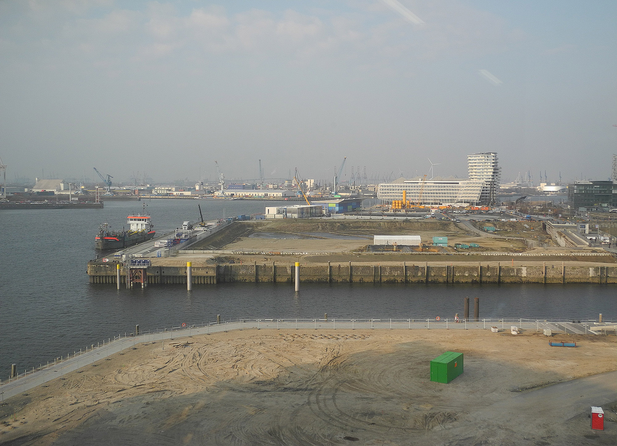
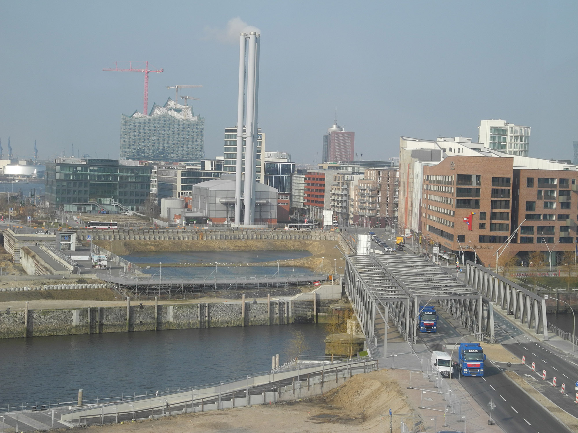
In 2004, a temporary cruise terminal received its first passengers at Hamburg and a new subway line was built. The world financial crisis caused some delays in implementation, especially in the centre piece, the Überseequartier, where in 2015 a new developer took over for the southern part. In 2008, the Maritime Museum was opened in Speicher B (Warehouse B). Most spectacular is the project of a concert hall (Elbphilharmonie) on top of Speicher A (Warehouse A). The landmark project has attracted a good deal of international attention not only because of the spectacular architecture but also because of rapidly increasing costs and delays in construction works. Already in the planning and construction phase of the “flagship project” it became a distinctive international new trade mark of the city.
An updated Masterplan for the eastern part of the HafenCity was decided in 2010. Three districts with a variety of uses are in the pipeline: Baakenhafen neighbourhood will be used for different types of housing and recreation. Oberhafen will be transformed to a creative and cultural district, where existing older warehouses will be reused and sport facilities right by the water will be provided. The most eastern district, Elbbrücken neighbourhood, will be the entrance gate with higher buildings and a mix of offices, residential and shopping facilities.
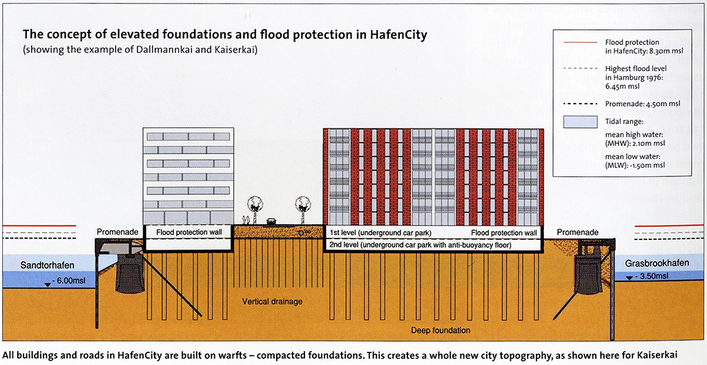
In HafenCity includes many projects with high ecological certificates (“Gold Standard”) dimensions of flexibility, redundancy, diversity, compactness, mix-use and also perspectives of adaption and resilience are included. Attractive promenades offer public access at all quays along the waterfront in the area. For flood protection a special strategy was developed, that streets are higher, flood protected level, while the ground floors serve for parking and the walkways can be overflooded.
IBA, IGS and the “Leap across the river”
The “Leap across the Elbe” implies that between 15.000 and 50.000 new citizens will be allocated in the marshlands of the river island Wilhelmsburg in the future. The area is especially affected by the transit traffic. The cutting of quarters by traffic roads and the noise exposure by road and rail traffic have become a challenge. So this was a special chance for Hamburg to move within an experimental scope of the Internationale Bauausstellung IBA Hamburg (International Building Exhibition) and the International Garden Show 2013, where many stakeholders were integrated in a future discussion about sustainable solutions for the future, not only for the island but also for the Hamburg region.
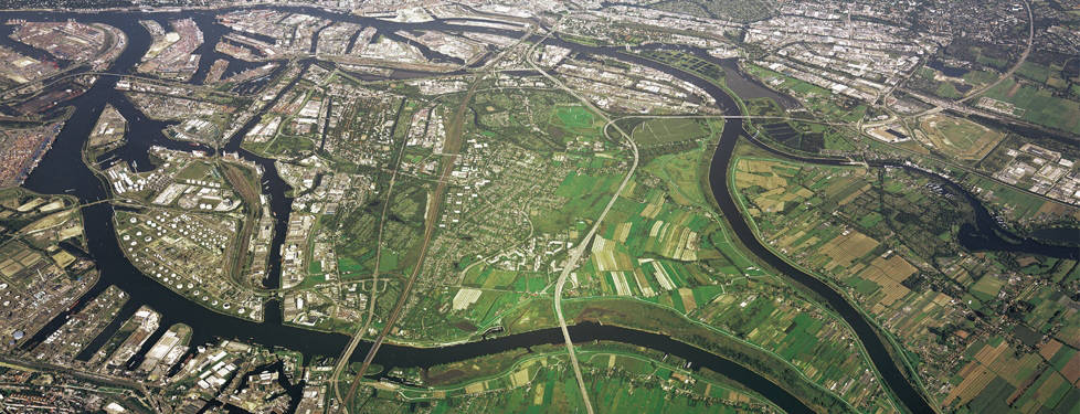
A new urban connection is planned from the city centre north of the river via HafenCity across the Elbe to Wilhelmsburg to Harburg Innerport and the south. Amidst these poles and bridge heads, Wilhelmsburg Mitte will become a new centre. But most importantly, the Reiherstieg, canals and the watercourses in Wilhelmsburg should become its new “life veins”. Wilhelmsburg had become the focus of iconic urban design and housing projects. The strategy also includes a more regional perspective. “Leap across the River Elbe” by also improving the housing and living conditions within the area.
Perspectives for a (more) smart and resilient future
In Hamburg this redevelopment takes place with an active port right in the middle of the city. The future requirements of space, technical infrastructure and new container terminals and environmental protection as well, generate a great and also costly challenge for the entire city.
Plans for the transformation of derelict waterfront sites in Hamburg started with a project and architecture-led incremental approach along the northern river bank. Conflicts arising between urban and port development were dealt with case by case, among the authorities and stakeholders. Rapid implementation of building projects was the prime goal. HafenCity implied a jump in scale and a more complex implementation strategy formulated with the city as developer and a project embedded in urban perspectives of inner-city development. HafenCity is a more plan-led and pro-active approach, while also improvements and updates of the plan related to changes in the office and housing market were possible. The implementation phase was predicted to last about 25 years.
The “Leap across the River”, on the other hand, reorganised the urban perspectives for the entire city. Using architectural projects, the geographical centre of Hamburg will be moved from the periphery into a new centre by means of a diverse range of projects and plans that are part of a long-term strategy. Initially, the existing building stock will be selectively enhanced and distinct innovative projects incorporated into an overall urban design concept which will restructure the interface between port and city. The upgrading of Wilhelmsburg will take many decades and must be balanced between requirements of the local inhabitants for affordable housing and dangers of partly gentrification.
The projects and plans illustrate paradigm shifts in urban planning not only in Hamburg into a direction of more flexibility. Sustainable, resilient, intelligent, long-term, or even “smart metropolis” strategies can only be gained by participative governance structures. Smart cities and smart ports should not only be a perspective for a more a efficient way to consume, resources like water, energy and transport but provide a holistic approach, which includes new forms of governance that emphasize on bottom-up approaches rather than top-down approaches.
Notes
[1] https://www.hamburg-port-authority.de/de/presse/broschueren-und-publikationen/Documents/140401_HPA_Broschuere_spl_web.pdf
References, viewed 15.03.2015.
[2] Restemeyer, B, Woltjer, J, Brink M van den, 2015, ‘A strategy-based framework for assessing the flood of cities – a Hamburg case study’, Planning Theory and Practice, Vol. 16, no. 1, pp. 45-62.
[3] Schubert, D, 2014, Three Contrasting Approaches to Urban Redevelopment and Waterfront Transformations in Hamburg, ISOCARP Review 10, pp. 48-60.
[4] HafenCity Hamburg GmbH, 2014, ‘Essentials, Quarters, Projects’, October, viewed 15.03.2015.
References
HafenCity Hamburg GmbH, 2014, ‘Essentials, Quarters, Projects’, October.
https://www.hamburg-port-authority.de/de/presse/broschueren-und-publikationen/Documents/140401_HPA_Broschuere_spl_web.pdf
Restemeyer, B, Woltjer, J, Brink M van den, 2015, ‘A strategy-based framework for assessing the flood of cities – a Hamburg case study’, Planning Theory and Practice, Vol. 16, no. 1, pp. 45-62.
Ryser, J, 2014, Planning Smart Cities … Sustainable, Healthy, Livable, CreativeCities … Or Just Planning Cities, No. 56, dérive Zeitschrift für Stadtforschung, Juli, pp. 10-18.
Schubert, D, 2014, Three Contrasting Approaches to Urban Redevelopment and Waterfront Transformations in Hamburg, ISOCARP Review 10, pp. 48-60.
Head image: River island Wilhelmsburg – The IBA area. (https://www.iba-hamburg.de/en/nc/projects/iba-map.html)