The border between North Korea and South Korea is one of the world’s largest gaps of Human Development Index between neighbor countries as mapped by Didelon et al. (2008). This situation stems from historical legacies, namely the division of the Korean Peninsula following the eponym war (1950-1953) and the divergent social, economic, and political evolution of the two countries until nowadays. Recent research has, however, demonstrated that multiple North-South relationships could overcome the closed border in the last decades (Gelézeau et al., 2013). Maritime transport, which supports about 90% of inter-Korean trade, is a good example of maintained interaction despite division.
In such respect, a recent report investigated the characteristics and evolution of inter-Korean maritime traffic, presented at the World Conference on North Korean Studies [1] in 2015, being part of a bigger report prepared for the Korean Maritime Institute (KMI) [2] about North Korea’s ports and maritime networks. The originality of the study is to make use of a largely untapped and first-hand database on vessel movements calling at North Korean ports, provided by Lloyd’s List Intelligence [3]. This information is by far a unique possibility to map and measure with precision North Korea’s economic activity, which is otherwise broadly estimated if not falsified or simply unknown. It prolongs and extends earlier studies of the kind by looking at the 1977-2015 period (see Ducruet et al., 2008).
Main results are fourfold. First, they confirmed the stable trade importance of maritime transport for North Korea, around 15%, in line with the so-called “Soviet” model of a transport system but also as an effect of trade embargo to limit illicit exchanges.
Second, the growing gap between North Korean and foreign vessels was highlighted, due to the rapidly ageing North Korean fleet and its shrinking capacity, as larger ships are too costly to maintain or purchase.
Third, North Korean port traffic had always been assumed by a majority of foreign vessels (except in 1997, a year of acute crisis combining natural disasters, trade embargo, and political transition), among which Chinese vessels had become dominant in recent years. Other aspects were also investigated, such as the average transit time of vessels at North Korean ports, daily and monthly traffic dynamics, domestic coastal shipping, and the distribution of external linkages. The case of inter-Korean flows is the fourth aspect developed here in the next paragraphs.
As seen in Figure 1, North Korea had been decreasingly connected with the “rest of the world” (i.e. outside Northeast Asia), as its trade relations with long-distance partners such as the former USSR for instance declined rapidly in the 1980s up to 2005, until humanitarian aid shipments changed the distribution in subsequent years. More impressive is the fading out of traffic with Japan, due to security issues, and with the Hong Kong hub (a good proxy for long-distance transit), by contrast with the growth of traffic with South Korea and China. The tremendous concentration of North Korea’s traffic at South Korean ports, especially after the 2004 inter-Korean maritime agreement in a context of warmer North-South diplomatic ties, and economic reforms in the North, motivated earlier studies to depict this process as growing hub dependence whereby economic factors superseded political factors in the design of maritime networks (Ducruet, 2008; see also Mohamed-Chérif and Ducruet, 2015 on the Maghreb case). Yet, such a trend was only a temporary palliative to North Korea’s difficulties and a perfect illustration of its pragmatism towards the outside world. But, a growing share of North-South trade occurs inland with the processing output of the Gaeseong Industrial Park from which 125 South Korean manufacturing firms ship their goods to South Korea for local consumption or re-export. The production volume of the industrial zone reached a peak in 2014 with US$ 470 million [4], compared with 149 million in 2005.
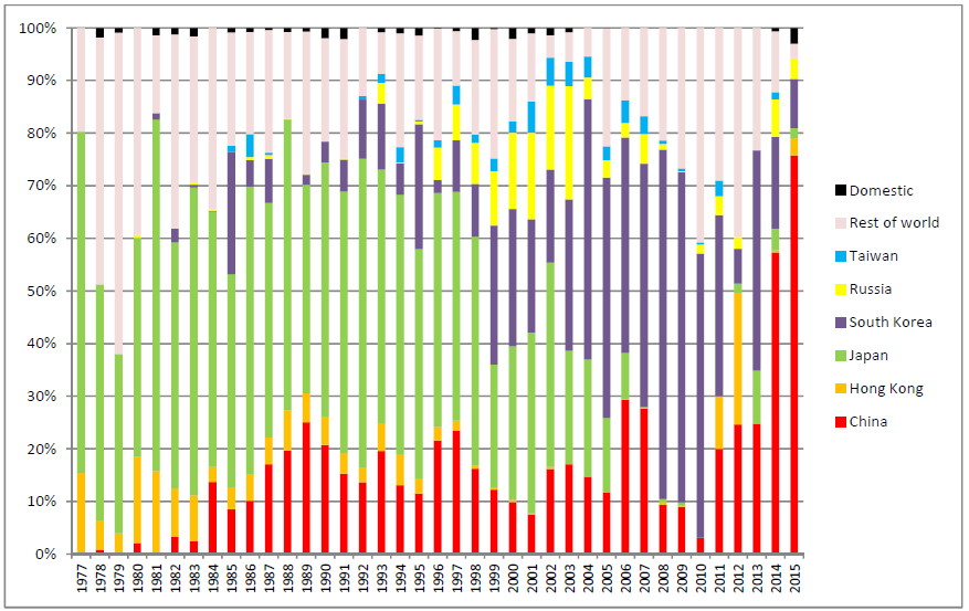
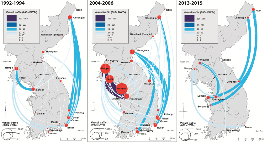
What became clear in recent years is the overwhelming dominance of China in North Korean foreign trade, now both applicable to landward (cross-border) and seaborne relationships. China now concentrates no less than 90% of North Korea’s trade, importing raw materials and exporting consumer goods. The effect on inter-Korean maritime flows (Figure 2) had been a spatial de-concentration process whereby the crucial link between Nampo and Incheon, the respective ports of the two capital regions of Pyongyang and Seoul, gradually disappeared. It was replaced by scattered linkages among secondary and remotely located ports such as Rajin in North Korea, which had been recently designed as a hub for inter-Korean coal trade [5].
This research provides a good example of how flexible can be maritime transport in a tense cross-border context that is usually known to the general public by the media coverage of naval disputes. As a vector of trade and exchanges, maritime transport reflects wider economic dynamics and at the same time, is able to bypass political borders. Nevertheless, flexibility goes along with instability in North-South maritime relationships, compared with the more stable and growing Gaeseong project. Increasing Chinese influence by both sea and land might have, however, important effects on future North-South relationships in the long run.
Notes
[1] https://www.wcnks.com/index_eng.php
[2] https://www.kmi.re.kr/kmi/en/
[3] https://www.lloydslistintelligence.com
[4] Source : Ministry of Unification in South Korea,, https://eng.unikorea.go.kr/content.do?cmsid=1822
[5] https://www.koreaherald.com/view.php?ud=20150427001274
References
Didelon C., Grasland C., Richard Y. (2008) Atlas de l’Europe dans le Monde. Paris: La Documentation Française.
Ducruet C., Gelézeau V., Roussin S. (2008) Les connexions maritimes de la Corée du Nord: Recompositions territoriales dans la péninsule coréenne et nouvelles dynamiques régionales en Asie du Nord-Est. L’Espace Géographique, 3 : 208-224.
Ducruet C., Roussin S., Jo J.C. (2009) Going West? Spatial polarization of the North Korean port system. Journal of Transport Geography, 17(5): 357-368.
Gelézeau V., De Ceuster K., Delissen A. (2013) De-Bordering Korea. London and New York: Routledge.
Mohamed-Chérif F.Z., Ducruet C. (2015) Regional integration and maritime connectivity across the Maghreb seaport system. Journal of Transport Geography, doi : 10.1016/j.jtrangeo.2015.01.013
Head Image: A view of the Incheon port.