╔
El “Llano Amarillo” como nueva centralidad urbana
Si bien es cierto que tenemos el orgullo de residir en una ciudad con varios siglos de vida, es ahora, en esta década, cuando estamos teniendo la oportunidad de ser protagonistas y partícipes del mayor desarrollo urbano de la historia de Algeciras.
Sin duda alguna, el “Llano Amarillo” es el eje urbano vertebrador del proyecto de ciudad que estamos desarrollando en los últimos años, y que se sostiene en el documento estratégico de ciudad, la Agenda Urbana Algeciras 2030 (AUA 2030), que tiene como objetivo final hacer de Algeciras una ciudad más amable, sostenible e igualitaria. Se trata de ofrecer una respuesta que favorezca un proyecto integral de ciudad permitiendo dar, de manera conjunta, un salto en igualdad, en calidad de vida de nuestra gente, en el medio ambiente urbano y el desarrollo sostenible de la economía.
Although it is true that we are proud to live in a city with several centuries of life, it is now, in this decade, when we are having the opportunity to be protagonists and participants of the biggest urban development in the history of Algeciras.
Undoubtedly, the “Llano Amarillo” is the urban backbone of the city project that we are developing in recent years, and that is supported in the strategic document of the city, the Urban Agenda Algeciras 2030 (AUA 2030), which has as its ultimate goal to make Algeciras a friendlier, sustainable and egalitarian city. It is about offering a response that favors an integral city project allowing to make, jointly, a leap in equality, in the quality of life of our people, in the urban environment and the sustainable development of the economy.
Agenda 2030 es la nueva agenda internacional de desarrollo aprobada en 2015 por las Naciones Unidas y en la que se inserta la Agenda Urbana Andalucía, un marco estratégico impulsado por la Consejería de Medio Ambiente y Ordenación del Territorio de la Junta de Andalucía con el objetivo de convertirse en un instrumento del desarrollo social y económico con horizonte temporal del 2030. (Link: www.agendaurbanaalgeciras.es).
Agenda 2030 is the new international development agenda approved in 2015 by the United Nations and in which the Andalusian Urban Agenda is inserted, as strategic framework promoted by the Counseling of Environment and Territorial Planning of the Government of Andalusia with the objective of become an instrument of social and economic development with a time horizon of 2030. (Link: www.agendaurbanaalgeciras.es).
La AUA 2030 nos ha permitido actualizar el diagnóstico de la ciudad a nivel social, ambiental, económico, espacial y de gobernanza, documento imprescindible para poder progresar, ya que consideramos que no podemos decidir a dónde queremos ir si no sabemos de dónde venimos. Es la hoja de ruta para ir hacia una ciudad más sostenible, alineándose con los grandes desafíos que debe afrontar la humanidad.
The AUA 2030 has allowed us to update the diagnosis of the city at social, environmental, economic, spatial and governance levels, an essential document for making progress, as we believe that we cannot decide where we want to go if we do not know where we have come from. It is the roadmap for moving towards a more sustainable city, aligning ourselves with the great challenges facing humanity.
Implantación de la Zona de Bajas Emisiones
Implementation of the Low Emission Zone
El proyecto por excelencia que podría definir el modelo de ciudad que queremos hacer de Algeciras, y que se refleja en la Agenda Urbana Algeciras 2030, es el proyecto “Lago Marítimo”, localizado en el frente norte del “Llano Amarillo”. Es un claro ejemplo de colaboración entre administraciones, con una finalidad clara, la de dar respuesta a la histórica demanda de recuperar para el uso ciudadano los espacios de transición entre el puerto y la ciudad, con una metodología enfocada a la sostenibilidad, la innovación y la integración, a través de la creación de nuevos espacios de convivencia para el uso y disfrute de los ciudadanos.
Este frente norte del “Llano Amarillo” constituye un área de centralidad dotacional, siendo el objetivo principal el de convertirla en un área descarbonizada, pasando a ser el punto de partida de la Fase I de implantación de la Zona de Bajas Emisiones de la ciudad, ampliando los espacios peatonales y disminuyendo la presencia del vehículo en todo el entorno, a través de actuaciones urbanístico-paisajísticas contempladas, además, en el Plan de Movilidad Urbano Sostenible de la ciudad.
El área de intervención se une al centro urbano a través de las actuaciones de mejora de la movilidad peatonal que se pretenden llevar a cabo en la calle Fray Tomás del Valle y las avenidas Fuerte Santiago, Capitán Ontañon y Virgen del Carmen, apostando, en todo momento, por una conectividad segura y accesible.
The project par excellence that could define the city model we want to make of Algeciras, and which is reflected in the Algeciras 2030 Urban Agenda, is the “Lago Marítimo” project, located on the northern front of the “Llano Amarillo”. It is a clear example of collaboration between administrations, with a clear purpose, that of responding to the historical demand of recovering for citizen use the transition spaces between the port and the city, with a methodology focused on sustainability, innovation and integration, through the creation of new spaces of coexistence for the use and enjoyment of citizens.
This northern front of the “Llano Amarillo” constitutes an area of centralized public services, the main objective being to convert it into a decarbonized area, becoming the starting point for Phase I of the implementation of the city’s Low Emission Zone, extending pedestrian spaces and reducing the presence of vehicles in the entire area, through urban-landscape actions that are also included in the city’s Sustainable Urban Mobility Plan.
The area of intervention is linked to the city center through the actions to improve pedestrian mobility that are intended to be carried out in Fray Tomás del Valle street and Fuerte Santiago, Capitán Ontañón and Virgen del Carmen avenues, with the aim of ensuring safe and accessible connectivity at all times.
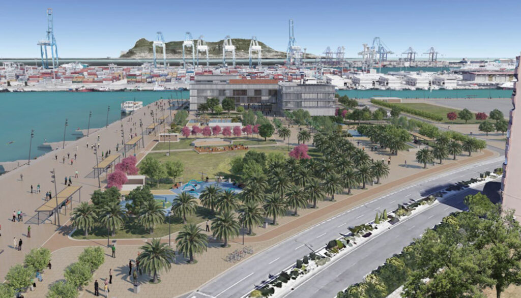
Lago Marítimo. Infografía Fase I ZBE. (Fuente: Autoridad Portuaria de la Bahía de Algeciras).
Lago Marítimo. Infographic Phase I ZBE. (Source: Algeciras Bay Port Authority).
La aplicación del conjunto de medidas y reformas destinadas a una mayor calidad ambiental, busca el mismo objetivo que otras ZBE ya operativas en nuestro país, y todo ello dentro de un plan más ambicioso, como es el recogido en la Ley de Cambio Climático, y la obligación legal de las grandes ciudades de tener una ZBE operativa en 2023. Con ello, se podrá conseguir una rebaja del NOx del 15% y del CO2 del 7%, en una fase inicial, diseñando un urbanismo más accesible y sostenible que haga de Algeciras una ciudad más amable.
En la zona norte litoral, en paralelo a la construcción del conjunto edificatorio contemplado en el proyecto “Lago Marítimo”, con usos públicos multifuncionales y dotado para dar cabida a espacios reservados a I+D+i, a la formación universitaria y a usos deportivos, se eliminarán las barreras físicas que existen en la actualidad. Para ello, se está ejecutando un proyecto urbanístico donde se contemplan actuaciones de calmado de tráfico a través de la implantación de una plataforma única en la intersección entre la avenida Virgen del Carmen con Fuerte Santiago; actuaciones urbanístico-paisajísticas en la avenida Virgen del Carmen, donde se contempla la eliminación de 150 plazas de aparcamiento para dar paso a una zona de tránsito peatonal, la creación de áreas de sombra y estancia mediante elementos de diseño urbano y áreas verdes en zonas cuyo uso actual es el de aparcamiento, que sirvan de pantalla de integración con la ciudad, con diferentes especies vegetales en base a los estudios específicos a realizar, que contribuirán a la disminución de los niveles de emisión de Gases de Efecto Invernadero (GEI), principalmente de CO2. En esta intervención se eliminarán las barreras arquitectónicas producidas por el desnivel actual de pavimentos, entre el muelle norte y el borde de contacto de la propia avenida, a los efectos de crear una continuidad formal y espacial que fomente la movilidad peatonal, priorizando en el uso de materiales de construcción innovadores de bioconstrucción, empleando, entre otros, pavimento fotocatalítico que contribuirá́ a la eliminación de la contaminación producida por los vehículos; ampliación del carril bici de la ciudad en la vía interior de las avenidas Virgen del Carmen, Capitán Ontañón, Blas Infante y calle Fuerte Santiago; y peatonalización de la vía interior de las avenidas Virgen del Carmen y Capitán Ontañón.
The application of the set of measures and reforms aimed at greater environmental quality, seeks the same objective as other ZBEs already operating in our country, and all within a more ambitious plan, such as the one included in the Climate Change Act, and the legal obligation of large cities to have an operational ZBE in 2023. With this, it will be possible to achieve a NOx reduction of 15% and a CO2 reduction of 7%, in an initial phase, designing a more accessible and sustainable urban planning that will make Algeciras a friendlier city.
In the northern coastal area, in parallel to the construction of the building complex contemplated in the “Lago Marítimo” project, with multifunctional public uses and equipped to accommodate spaces reserved for R+D+i, university education and sports uses, the physical barriers that currently exist will be eliminated. To this end, an urban planning project is being carried out which contemplates traffic calming actions through the implementation of a single platform at the intersection between Avenida Virgen del Carmen and Fuerte Santiago; urban-landscape actions on Avenida Virgen del Carmen, where the elimination of 150 parking spaces is envisaged to make way for a pedestrian transit area, the creation of shaded and shaded areas through urban design elements and green areas in areas currently used for parking, which will serve as a screen for integration with the city, with different plant species based on the specific studies to be carried out, which will contribute to reducing the levels of Greenhouse Gas (GHG) emissions, mainly CO2. This intervention will eliminate the architectural barriers caused by the current unevenness of pavements between the north pier and the contact edge of the avenue itself, in order to create a formal and spatial continuity that promotes pedestrian mobility, prioritizing the use of innovative bio-construction construction materials, using, among others, photocatalytic paving that will contribute to the elimination of pollution caused by vehicles; extension of the city’s cycle lane on the inner roads of the avenues Virgen del Carmen, Capitán Ontañón, Blas Infante and Calle Fuerte Santiago; and pedestrianization of the inner roads of the avenues Virgen del Carmen and Capitán Ontañón.
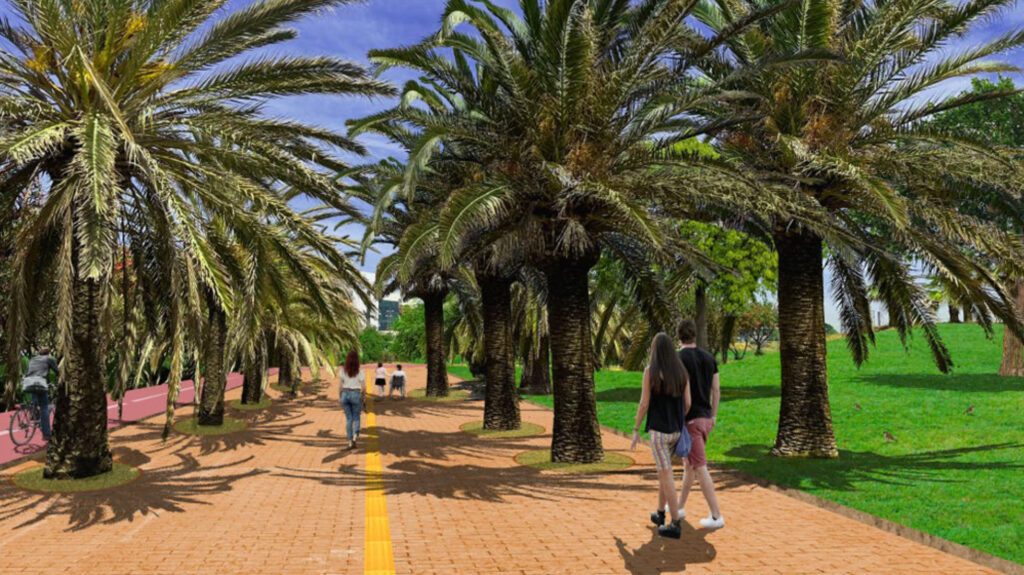
Lago Marítimo. Infografía Fase I ZBE. (Fuente: Autoridad Portuaria de la Bahía de Algeciras).
Lago Marítimo. Infographic Phase I ZBE. (Source: Algeciras Bay Port Authority).
Actuación “Agua Limpia”
“Agua Limpia” Action
Continuando con la apuesta del “Llano Amarillo” como eje central de la nueva realidad urbana de la ciudad, se ha convertido, igualmente, en el espacio urbano referente por el que se está llevando a cabo un proyecto medioambiental, “Agua Limpia”, cuya finalidad es la eliminación de vertidos, eliminado los malos olores, y la regeneración de la lámina de agua de dicho entorno para dar paso a un lugar donde converge el puerto y la ciudad. Para ello, se está actuando en tres áreas prioritarias: el desvío norte del río de La Miel, las EBAR Virgen del Carmen y La Concha, y el aliviadero de la EDAR Los Ladrillos. Una vez llevada a cabo dichas actuaciones, se realizará un dragado ecológico de la dársena de Los Ladrillos que eliminará los lodos existentes.
La zona que presenta mayor afección de vertidos es concretamente la Estación de Bombeo de Aguas Residuales de Los Ladrillos, en torno al gran proyecto del “Lago Marítimo” del “Llano Amarillo”, que ante lluvias fuertes las aguas arrastran restos de vertidos que se sedimentan en la desembocadura. La solución propuesta pasa por desviar gran parte de las aguas pluviales a través de la construcción de infraestructuras de saneamiento y evacuación, y la construcción de una nueva estación de bombeo de aguas residuales que aumente la capacidad de impulsión hacia la depuradora. Esta actuación urbanística medioambiental se completará con la construcción de un tanque de tormentas de 5.000 metros cúbicos de capacidad, que contendrá las primeras aguas de lluvia que traen la mayor cantidad de partículas acumuladas en las superficies impermeables de las cuencas urbanas.
Continuing with the commitment to the “Llano Amarillo” as the central axis of the new urban reality of the city, it has also become the urban space of reference for which an environmental project is being carried out, “Agua Limpia”, the aim of which is to eliminate dumping, eliminate bad smells and regenerate the sheet of water in this area to make way for a place where the port and the city converge. To this end, work is being carried out in three priority areas: the northern diversion of the La Miel river, the Virgen del Carmen and La Concha wastewater treatment plants, and the spillway of the Los Ladrillos wastewater treatment plant. Once these actions have been carried out, an ecological dredging of the Los Ladrillos basin will be carried out to eliminate the existing sludge.
The area most affected by discharges is the Los Ladrillos sewage pumping station, around the large “Lago Marítimo” project on the “Llano Amarillo”, which, in the event of heavy rainfall, carries the remains of discharges which settle at the mouth of the lake. The proposed solution involves diverting a large part of the rainwater through the construction of drainage and evacuation infrastructures and the construction of a new sewage pumping station to increase the pumping capacity to the treatment plant. This urban environmental action will be completed with the construction of a storm tank with a capacity of 5,000 cubic meters, which will contain the first rainwater that brings the greatest quantity of particles accumulated on the impermeable surfaces of the urban basins.
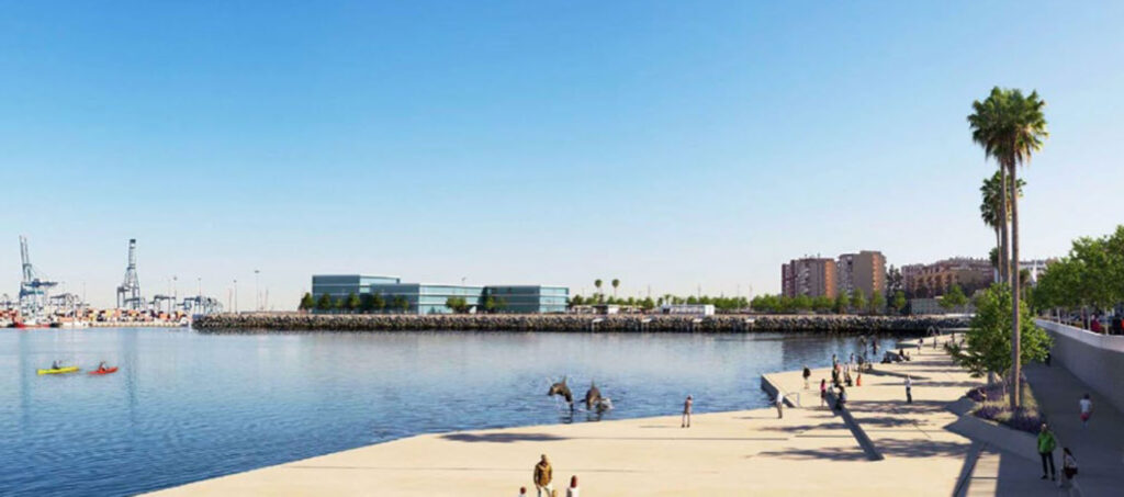
Aguas residuales de Los Ladrillos. Infografía de lámina de agua – Actuación “Agua Limpia”. (Fuente: Autoridad Portuaria de la Bahía de Algeciras).
Los Ladrillos wastewater. Water sheet infographic – “Agua Limpia” Performance. (Source: Algeciras Bay Port Authority).
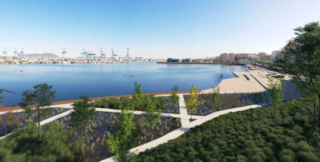
Infografía del futuro parque humedal. (Fuente: Autoridad Portuaria de la Bahía de Algeciras).
Infographic of the future wetland park. (Source: Algeciras Bay Port Authority).
Además, apostando por la innovación y la sostenibilidad medioambiental urbana, se está desarrollando un proyecto obtenido con fondos europeos, para la ejecución de un parque humedal de depuración natural con plantas, incluido como Urban Real Lab en el plan H2020 de la iniciativa NICE (Innovative and Enhanced Nature-Based Solutions for Sustainable Urban Water Cycle) de la Comisión Europea, que fue firmado el 10 de mayo de 2021. Las aguas que se traten en el parque humedal se usaran para el riego de las zonas ajardinadas del Paseo de la Cornisa que discurre por la lámina de agua del entorno del “Llano Amarillo”.
In addition, in a commitment to innovation and urban environmental sustainability, a project is being developed with European funds for the implementation of a wetland park for natural purification with plants, included as Urban Real Lab in the H2020 plan of the NICE initiative (Innovative and Enhanced Nature-Based Solutions for Sustainable Urban Water Cycle) of the European Commission, which was signed on 10 May 2021. The water treated in the wetland park will be used to irrigate the landscaped areas of the Paseo de la Cornisa, which runs along the water surface around the “Llano Amarillo”.
Regeneración urbana en la playa de la Concha
Urban Regeneration on La Concha Beach
Para finalizar, hay que mencionar una actuación de regeneración paisajística, que viene a culminar el gran proyecto de ciudad que tiene como eje de la nueva centralidad urbana de la ciudad en el “Llano Amarillo”: la playa de La Concha, localizada en la zona norte del puerto, en la barriada de El Rinconcillo. La intervención ha consistido en eliminar una antigua depuradora de aguas residuales, descontaminar los suelos, dando paso a una gran plaza abierta al mar, con nuevos usos recreativos y deportivos que aportan un gran valor ambiental y paisajístico a la bahía de Algeciras.
Finally, mention should be made of a landscape regeneration project, which is the culmination of the great city project that is the axis of the new urban center of the city on the “Llano Amarillo”: the beach of La Concha, located in the northern part of the port, in the Rinconcillo neighborhood. The intervention has consisted of eliminating an old sewage treatment plant, decontaminating the soil, giving way to a large square open to the sea, with new recreational and sporting uses that add great environmental and landscape value to the bay of Algeciras.
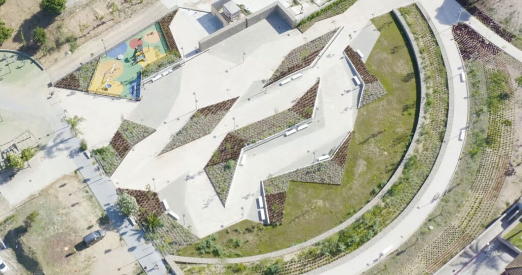
Actuación de la regeneración paisajística de la Playa de la Concha. (Fuente: Ayuntamiento de Algeciras).
Performance of the landscape regeneration of Playa de la Concha. (Source: Algeciras City Council).
El objetivo general que se persigue con el proyecto de regeneración urbana que estamos implantando en la ciudad de Algeciras, va más allá de las habituales consideraciones urbanísticas, arquitectónicas y de conservación del Patrimonio Histórico y Natural. Debe ofrecer soluciones adecuadas para resolver los problemas de carácter social, económico y asistencial de la población vulnerable, a través de la implementación de una serie de acciones coherentes y programadas, orientadas a potenciar los valores urbanos, ambientales, socioeconómicos y funcionales de una zona urbana determinada, con operaciones encaminadas a la mejora del equipamiento y la infraestructura urbana, que incrementen los niveles de habitabilidad, servicios, dotaciones y espacios comunitarios necesarios para tener una mejor calidad de vida.
La filosofía de nuestro proyecto de ciudad, de presente y futuro, está alineada con el Pacto Verde Europeo, inspiración de una estrategia de crecimiento y transformación de la realidad local, a través de la recuperación de los recursos naturales y patrimoniales, el paso a una economía baja en carbono de una manera inclusiva e integradora, y la lucha contra la degradación ambiental, incluyendo actuaciones de economía circular y tecnologías, donde el puerto y la ciudad conformen un modelo de urbanismo integrador.
En definitiva, planteamos un modelo urbano de ciudad portuaria dinámica y abierta al futuro, que tiene como “brújula” nuestro conocimiento estratégico de ciudad, recogido en la Agenda Urbana Algeciras 2030.
Más información
https://www.agendaurbanaalgeciras.es/
The general objective pursued with the urban regeneration project that we are implementing in the city of Algeciras goes beyond the usual urban, architectural and conservation considerations of the Historical and Natural Heritage. It must offer adequate solutions to solve the social, economic and welfare problems of the vulnerable population, through the implementation of a series of coherent and programmed actions, aimed at enhancing the urban, environmental, socio-economic and functional values of a given urban area, with operations aimed at improving the equipment and urban infrastructure, which increase the levels of habitability, services, facilities and community spaces necessary to have a better quality of life.
The philosophy of our city project, present and future, is aligned with the European Green Pact, inspiration of a strategy of growth and transformation of the local reality, through the recovery of natural and heritage resources, the transition to a low carbon economy in an inclusive and integrating way, and the fight against environmental degradation, including actions of circular economy and technologies, where the port and the city form a model of integrating urbanism.
In short, we propose an urban model of a dynamic port city open to the future, which has as its “compass” our strategic knowledge of the city, included in the Algeciras 2030 Urban Agenda.
More information
https://www.agendaurbanaalgeciras.es/
IMAGEN INICIAL | Llano Amarillo. Infografía del futuro parque de humedales. (Fuente: Autoridad Portuaria de la Bahía de Algeciras).
HEAD IMAGE | Llano Amarillo. Infographic of the future wetland park. (Source: Algeciras Bay Port Authority).