╔
Context and History
The River Clyde stretches for around 170 km, rising in the Lowther Hills in South Lanarkshire and flowing into the Firth of Clyde and the North Atlantic. Greater Glasgow is the largest urban area within its catchment, and the city’s history is closely tied to the river.
Over the past two centuries, the Clyde and its surrounding communities have undergone significant change in form and function. In the 19th and early 20th centuries, the river was central to Glasgow’s growth: first as a gateway for trade with the Americas, and later as a major industrial centre and global industrial hub for shipbuilding and defence. The river was dredged and canalised to support this expansion, underpinned by Lanarkshire’s natural resources and access to markets across the British Empire. This industrial legacy continues to shape the region’s economy today.
Aerial Photograph of Queen’s and Prince’s Docks in 1932. (Image credit: Glasgow City Council, Glasgow Museums).
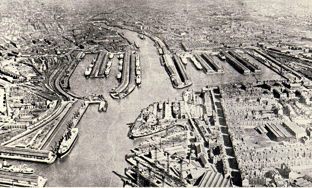
By the early 20th century, exports from the Clyde had established Glasgow as a leading global economic centre. The river also served as a key transport and trading route, handling large volumes of goods and passengers. This riverside economy peaked before the First World War and remained important through the Second World War, when shipbuilding played a vital role in supplying naval and merchant vessels.
From the 1950s onwards, technological and economic changes began to weaken the Clyde’s central role. The decline of heavy industry, alongside Britain’s shift to a service-based economy, left the riverfront increasingly vulnerable. Global changes in shipping, including containerisation and the move towards fewer, larger ports, reduced the need for traditional infrastructure, and commercial activity moved downstream.
Despite this decline, the Clyde remains an important centre for maritime and defence industries, including shipbuilding and ship management.
A City in Transition
Glasgow’s post-industrial transition is reflected in sustained investment in its waterfront and former docklands over the past 40 years. This began in the 1980s with the construction of the Scottish Events Campus and the hosting of the Glasgow Garden Festival.

Map of Glasgow Garden Festival – held on the partly infilled Prince’s Docks, 1988. (Image credit: Glasgow City Council, Glasgow Museums).
Between 2003 and 2014, the Clyde Waterfront partnership (comprising the Scottish Government, Scottish Enterprise, Glasgow City Council, and Renfrewshire and West Dunbartonshire councils) led the regeneration of 13 miles of the River Clyde, from Glasgow city centre to Dumbarton. The 2008 global financial crisis stalled private sector development, but City Deal funding, awarded in 2016, brought renewed public investment. This included projects such as the Govan–Partick Bridge, which opened in 2024. City Deal funding will continue to support infrastructure projects until at least 2035.
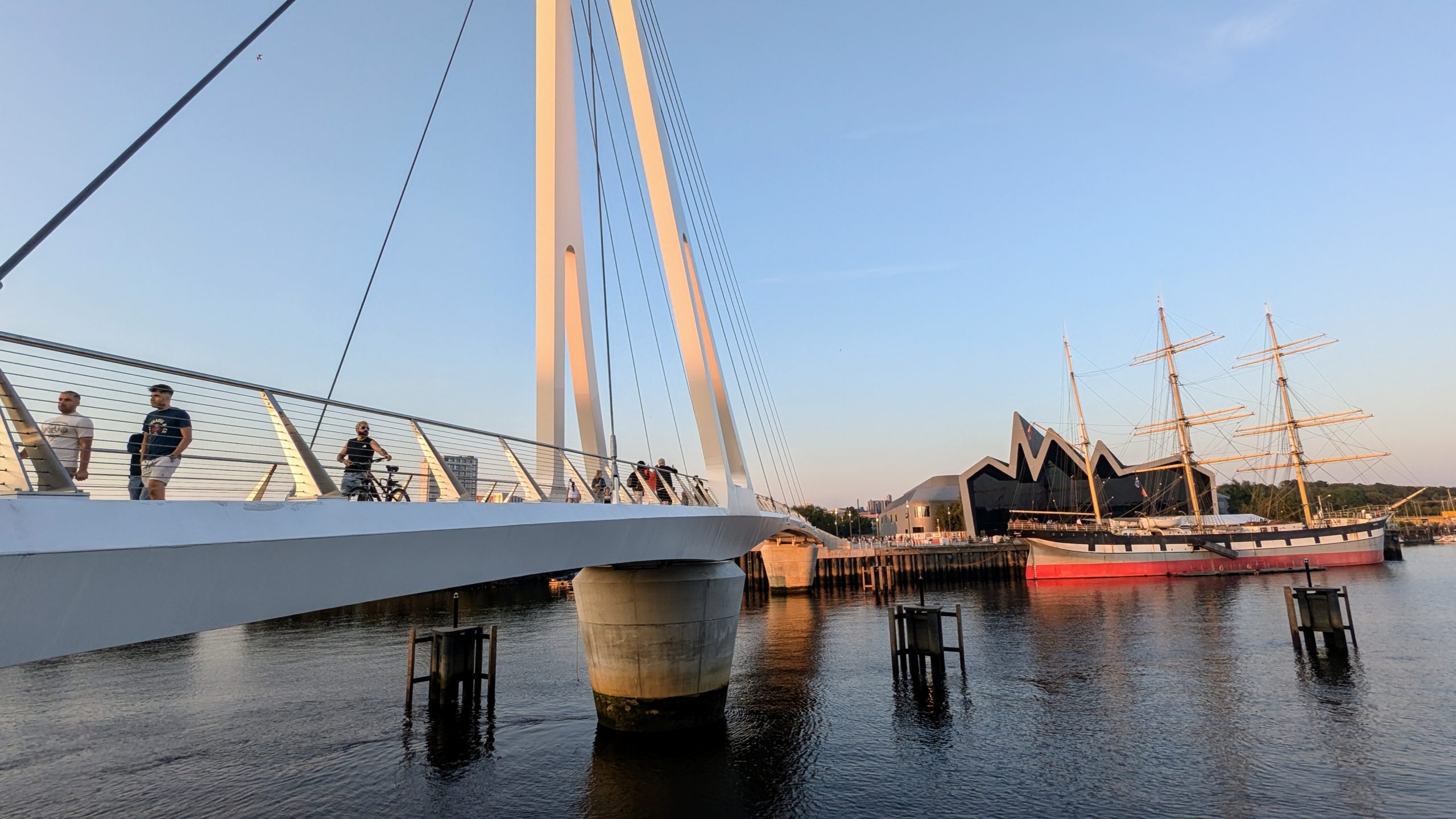
Govan to Partick Bridge and the Riverside Museum. (Image credit: Glasgow City Council).
More recently, the city has shifted towards a knowledge-based economy. New hubs for education, healthcare and employment have supported growth in innovation, life sciences, finance, and the creative industries. The proximity of the University of Glasgow strengthens the waterfront’s potential as a location for research and investment.
This activity has focused on key parts of the river corridor, creating high-quality destinations for culture, leisure and education. These include the Scottish Events Campus, Glasgow Science Centre and the Riverside Museum, which together attract millions of visitors each year. At the same time, developments in Laurieston, Govan and Glasgow Harbour are establishing new residential communities.
Glasgow Science Centre and Imax Cinema – built on the 1988 Garden Festival site, the former Prince’s Dock. (Image credit: Glasgow City Council).

The strategic importance of the River Clyde has been reinforced by the Scottish Government through the Clyde Mission, designated as a National Development in National Planning Framework 4. This long-term programme aims to position the river as a driver of sustainable and inclusive growth, supporting regeneration, innovation, decarbonisation, and improved environmental and social outcomes. In 2023, responsibility for the Clyde Mission transferred to the Glasgow City Region.
Ongoing Issues
The social, economic and environmental impacts of deindustrialisation have had a lasting effect on the River Corridor and the city’s inner urban core. Despite recent investment, significant challenges remain, limiting its ability to deliver inclusive economic growth and the benefits expected of a central urban area.
Deindustrialisation has left many large, prominent vacant and derelict sites along the river, several of which remain undeveloped. Some, such as those near the mouth of the River Kelvin, sit close to established communities and recent investment. Clusters of vacant land within the International Financial Services District are also visible from key gateways into the city, detracting from overall quality of place.
Changes in the maritime sector, combined with ageing infrastructure, have created challenges such as deteriorating quay walls. Alongside issues like land contamination, these increase the complexity of redevelopment and act as barriers to movement, particularly along and across the south bank.
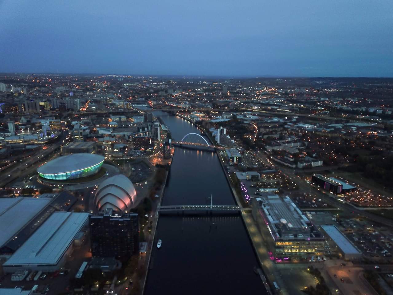
Aerial Photograph of the Scottish Events Campus and the BBC Scotland HQ, former Queen’s and Prince’s Docks. (Image credit: Glasgow City Council).
Climate change presents an increasing challenge, especially in relation to flood risk and surface water management. This is compounded by historic patterns of development and ongoing pressure for riverside growth. The functional floodplain, which extends along much of the corridor, further constrains the redevelopment of brownfield land.
While the River Corridor supports a wide mix of uses, some areas remain highly specialised and lack the diversity needed to create vibrant places. Physical barriers, limited walking and cycling routes, and safety concerns contribute to a fragmented urban form. Although transport infrastructure provides strong road access, it also creates severance, particularly around the Clydeside Expressway. Fragmented land ownership adds further complexity to coordinated regeneration.
Glasgow’s Approach to Waterfront Regeneration
The Council recognises the need to set out a clear and ambitious vision for the River Clyde, alongside a strategic planning and infrastructure approach to guide its long-term development.
To support this, Glasgow City Council has prepared a series of strategic spatial planning frameworks and a design guide to shape and promote the ongoing regeneration of the River Corridor:
- The River Clyde Strategic Development Framework – SDF [1]
- City Centre SDF [2]
- Govan and Partick SDF [3]
- Designing with Water, Design Guidance for Glasgow’s River Corridor [4]
Together, these frameworks promote a holistic, place-based approach to regeneration. They set out a transformational vision for the River Corridor in Glasgow as a liveable and well-connected place that successfully integrates placemaking with sustainable, flood-resilient design.
The Council’s ambitions for the River Corridor place it at the scale of a major urban renewal project – balancing regeneration (and its wider social, environmental and economic benefits) with the complexities of flood management and climate change. Retreating from the river is not considered a proportionate response if the long-term objective is to create a liveable city, to support integration with existing neighbourhoods and to attract people to the waterfront. The Council’s approach moves beyond a focus on economic growth alone, by seeking to improve the overall health and resilience of former dockland areas. The Council’s objectives are intended to reinforce one another over time and focus on:
- Achieving an urban density that supports and promotes existing clusters of economic, scientific and cultural activity
- Connecting the river to surrounding neighbourhoods and improving access along both banks
- Bringing forward remaining waterfront sites and creating new destinations
- Re-establishing the River Clyde as Glasgow’s social, economic and environmental heart by transforming fragmented waterfronts into a continuous, people-focused, climate-resilient “River Park”.
Designing with Water embeds these core principles into design guidance used to shape development proposals within the River Corridor. This guidance sets parameters for the development of vacant sites and the creation or enhancement of open space on land vulnerable to flooding. It recognises that development at key locations has the potential to improve open space provision, as part of delivering the wider River Park concept, and to act as a major recreational attractor.
The guidance encourages buildings to face the river, with active ground-floor uses that can adapt to flooding. It also includes a requirement for a minimum 12-metre setback from the river on both sides. Within this space, creative and playful landscaping is encouraged. This landscaping should serve multiple purposes, helping to manage climate impacts, support wildlife, and improve accessibility, while also providing dedicated paths for walking and cycling.
A Need for Regional Coordination
Stakeholder engagement has consistently highlighted several key issues: the absence of a unified, long-term regional governance and stewardship model for the River Corridor; the need to safeguard irreplaceable river-dependent sites for maritime, defence and energy industries; and the importance of coordinated action to address contamination, unstable ground conditions, green and blue infrastructure, and climate adaptation. There is also strong agreement on the need to link economic growth to local skills development, improved connectivity and inclusive growth, so that communities along the full length of the Clyde benefit directly from future investment.
Glasgow City Council’s planning frameworks and successful waterfront regeneration initiatives provide a strong foundation for a coordinated, corridor-wide approach. Building on this, Glasgow City Region (GCR), in partnership with Argyll and Bute Council and with support from the Scottish Government, is leading the Clyde Mission Strategic Masterplan, a national development priority that takes a long-term view of the entire River Clyde corridor.
The masterplan recognises the river’s diverse character: from the rural headwaters in South Lanarkshire, through the dense urban core in Glasgow, to the estuarine and coastal communities of the Firth of Clyde. It builds on the place-based principles established in Glasgow’s planning frameworks, while coordinating regeneration in a way that responds to local context and maximises shared opportunities.
This regional approach is supported by significant ongoing investment and partnership initiatives, including:
- The Glasgow City Region City Deal, which has delivered major infrastructure projects such as the Govan–Partick Bridge, Renfrew Bridge and the Clyde Waterfront and West End Innovation Quarter
- The Glasgow City Region Investment Zone, focused on advanced manufacturing, maritime and innovation sectors, including a major site at the Advanced Manufacturing Innovation District Scotland (AMIDS)
- Complementary programmes such as Clyde Gateway’s £500 million Innovation Masterplan, supporting high-value manufacturing, business space and mixed-use development
Following completion of the Strategic Masterplan, the Clyde Mission will be supported by a prioritised delivery programme and a robust business case. This will provide a clear long-term roadmap to align public and private investment, reduce risk on complex sites, and deliver sustainable and inclusive growth, helping to transform the River Clyde into a vibrant, climate-resilient corridor for the city, the wider region and Scotland.
Project Case Studies
The following case studies demonstrate how the principles outlined in the development frameworks have been embedded in regeneration efforts on the Clyde waterfront. They showcase different mechanisms and approaches to achieving the overall goal of putting the Clyde back at the heart of city life.
The work in Govan, in particular, shows how partnership working with the community can deliver inclusive, meaningful, and lasting change. Meanwhile, the work at Custom House Quay demonstrates our commitment to embedding the principles of feminist urbanism.
North Laurieston Masterplan
North Laurieston forms the northern part of the Laurieston neighbourhood, within Glasgow’s wider Gorbals community. It lies on the south bank of the River Clyde and is connected to the city centre by three historic bridges. A walk across the Victorian suspension bridge brings you to Carlton Place in around ten minutes.
At its northern edge, two grand Georgian terraces create a striking gateway to what was once a thriving riverside neighbourhood that aimed to rival Glasgow’s West End in quality and ambition. As the city industrialised, Laurieston adapted to meet growing transport and economic demands, with landmark buildings including banks, drapers’ warehouses and the city’s former main railway station.

Aspirational artistic impression of Bridge Street, North Laurieston viewed from Glasgow Bridge. (Image credit: Glasgow City Council, New Gorbals Housing Association, Elder and Cannon Architects).
Today, North Laurieston is the only part of the Gorbals yet to be fully regenerated. While neighbouring areas have been largely redeveloped, it still retains elements of its Victorian and pre-war heritage within the original street layout. However, this historic fabric is deteriorating, and the area is now dominated by heavy traffic and underinvestment.
Despite these challenges, North Laurieston remains a place of activity, with residents, businesses and a growing creative sector. Its heritage assets, strong transport links, proximity to the city centre and riverside setting provide significant potential for renewal.
Glasgow City Council is working with New Gorbals Housing Association (a registered social landlord) to prepare a regeneration masterplan. The area was previously part of the wider Laurieston Transformational Regeneration Area (TRA), which adjoins it to the south and is due for completion in 2028. However, unlike the largely council-owned TRA land, North Laurieston has a mix of uses and fragmented ownership, requiring a more flexible approach.
The masterplan focuses on addressing these complexities through urban repair, while engaging residents, businesses and landowners in shaping a shared vision. It sets out how the area can improve over time while responding to immediate community and environmental needs. Continued collaboration will be essential to its delivery.
A series of short, medium and long-term interventions are proposed. These include redeveloping vacant and underused sites, restoring buildings in poor condition, reducing traffic dominance, and creating more pedestrian and cycle friendly streets. Improvements to public spaces and the wider environment are also central. An “infrastructure-first” approach will prioritise early investment in public realm and high-quality affordable housing to build confidence and support future development. This will be supported by immediate maintenance works to demonstrate progress and prevent further decline.
North Laurieston sits within a wider programme of regeneration across the city centre and south bank. The completion of the adjoining TRA, upgrades to cultural assets such as the Citizens Theatre, and improved connections – including the Arch 12 route [4] [5] – will strengthen links across the area. However, regenerating North Laurieston is key to reconnecting these areas to the river and city centre, and to completing the wider neighbourhood.
Along the waterfront, the Barclays Campus at Buchanan Wharf is complete, while sites at the former Adelphi Centre and Custom House Quay are being transformed. North Laurieston is a critical missing piece in this wider regeneration. Positioned within Glasgow’s emerging “South Bank” vision, its renewal will help create a more connected, cohesive and sustainable urban waterfront.
The draft masterplan was presented to Glasgow’s elected members in spring 2026, at which point permission was granted to invite public comment over a six-week period during summer 2026. Following this consultation, the masterplan will be revised and subsequently ratified by the city’s elected members, after which it will gain formal status.
In practice, this means it will become a material consideration in planning decision-making, guide public sector investment programmes and attract inward investment from the private sector to support the comprehensive redevelopment of the area. Some elements of this work are likely to be long-term, so an infrastructure-first approach will be taken. Improving the quality of the public realm will be key to building investor confidence and attracting developer interest.
The Council will work with property owners to support the management and enhancement of their heritage buildings and will use statutory powers, where necessary, to address deterioration and bring these assets back into productive use.
Custom House Quay and Carlton Place
The Custom House Quay and Carlton Place project, currently at final design stage with construction anticipated between 2027 and 2029, marks a significant step in the transformation of Glasgow’s city centre waterfront. As part of the Glasgow City Region City Deal, the scheme supports the long-term ambition of creating a continuous River Park along the Clyde. It presents a rare opportunity to reconnect the city with its river edge and redefine it as a resilient and inclusive urban destination.
Positioned within the wider regeneration of Glasgow city centre and North Laurieston, the project will strengthen connections across the Clyde, helping to better integrate established commercial areas with growing residential communities to the south. In doing so, it will support a more cohesive urban structure and reinforce the Clyde’s role as a key civic spine.
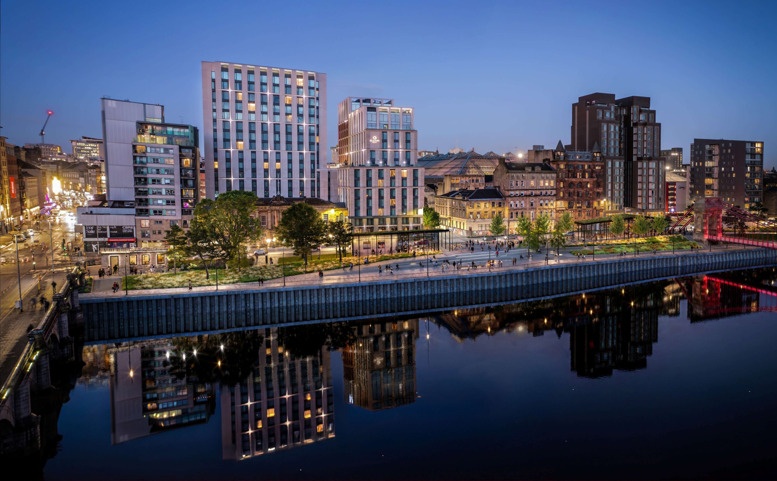
Aspirational artistic impression of Custom House Quay. (Image credit: Glasgow City Council).
The masterplan, developed by a multidisciplinary team led by Hawkins\Brown, takes a design-led placemaking approach. It responds sensitively to the historic townscape while enhancing environmental quality. At its core, the scheme combines essential infrastructure works – renewing the structural integrity of the quay walls – with the redesign of existing open spaces to create a fully accessible riverfront park.
The proposed River Park will deliver enhanced green infrastructure, high-quality public realm and improved connectivity along the river corridor. A strong emphasis is placed on activation, with amenities and features designed to support everyday use, encourage social interaction and increase dwell time, helping to create a lively and engaging waterfront.
In October 2022, Glasgow City Council passed a motion to adopt a feminist town planning approach within planning policy and the new City Development Plan. The motion also recognised that Glasgow has committed to embedding the UN Sustainable Development Goals within the City Development Plan, in particular SDG 5 – achieving gender equality and empowering all women and girls.
A Feminist Planning Toolkit has been commissioned to provide practical guidance on applying these principles across city development. Funding has also been agreed to support engagement with women and girls (including at Custom House Quay) and to deliver interventions in parks across the city.
The Custom House Quay project has been used as a testbed for this feminist town planning approach. Targeted engagement with women took place through three workshops during summer 2025. The workshops explored the following themes:
- Walking the River: a feminist lens on public space
- Reclaiming the River: local heritage through feminist stories
- Spatial Comfort: a spatial exploration of the proposed masterplan
Participants represented a range of organisations and groups. Their recommendations emphasised the need for a site that is safe, welcoming, socially engaging, and rooted in Glasgow’s identity. These recommendations will be explored further through ongoing design development as the project progresses.
Resilience and inclusivity are embedded throughout the design. Climate-adaptive drainage, improved walking, wheeling and cycling routes, and principles informed by feminist urbanism prioritise safety, visibility, accessibility and comfort. This approach ensures the space is welcoming and functional for a wide range of users throughout the day and across seasons.
Aligned with key city strategies for the Clyde Corridor and wider urban regeneration, the project demonstrates how targeted, design-led investment can deliver lasting change. Once complete, it will help reposition the waterfront as an active, connected and inclusive civic space at the heart of Glasgow.
Central Govan Action Plan and Townscape Heritage Initiative
The Central Govan Action Plan (CGAP) provides a strong example of inclusive town centre regeneration on the waterfront, delivered through partnership between the City Council, the local community and local organisations. The CGAP Project launched in 2006 as a community led investment and Development framework, guiding over £120million pounds of investment. Govan has deep history at the Clyde and Kelvin. It was Strathclyde’s medieval major centre, evidenced by Govan Old Church stones, later becoming a renowned 19th–20th century shipbuilding industrial boomtown. The area was significantly affected by the demolition of historic townscape and deindustrialisation between the 1960s and 1990s, and some of the communities within the area are amongst the most deprived in Scotland.
Early medieval sculpture. (Image credit: Govan Heritage Trust / The Govan Stones).

Govan was the birthplace of Scotland’s community-based housing association movement in the 1970s. Their efforts to save the area’s distinctive sandstone tenements from demolition helped build support for greater investment in the historic built environment. In 2006, the Council, working in partnership with the local community, prepared the original CGAP area renewal strategy. This continues to guide the collaborative approach to regenerating Govan town centre.
The Central Govan Action Plan sets out the overarching regeneration strategy for the area. Its aim is to create a thriving and distinctive town centre that supports local communities while reconnecting Govan to the River Clyde.
Govan in the 1970s. (Image credit: James MacDonald / Govan Reminiscence Group).

The plan promotes heritage-led regeneration, improvements to public spaces around Govan Cross, better connections to the river, and the reuse of vacant and underused buildings. It also places strong emphasis on local economic activity, skills development and community participation, ensuring that regeneration benefits those who live and work in the area.
Between 2009 and 2023, the Govan Cross Townscape Heritage Initiative (THI) and Conservation Area Regeneration Scheme (CARS) focused on the repair and renewal of Govan’s historic core. These programmes supported the conservation of traditional tenements, shopfronts and landmark buildings that define the character of the Cross. Funding has now been secured for a further five-year programme of historic building repair through the Govan Heritage Programme.

Shopfront improvements in central Govan. (Image credit: Glasgow City Council).
By investing in building repair, traditional skills and the reuse of upper floors, the THI/CARS programmes and Govan Heritage Programme help stabilise the townscape and encourage new activity. This physical renewal provides a foundation for wider cultural and economic regeneration across the town centre.
The Govan–Partick Strategic Development Framework sets out a long-term vision for the wider river corridor on both sides of the Clyde. It guides the development of key sites, including former industrial land and the waterfront, with a strong emphasis on high-quality placemaking.
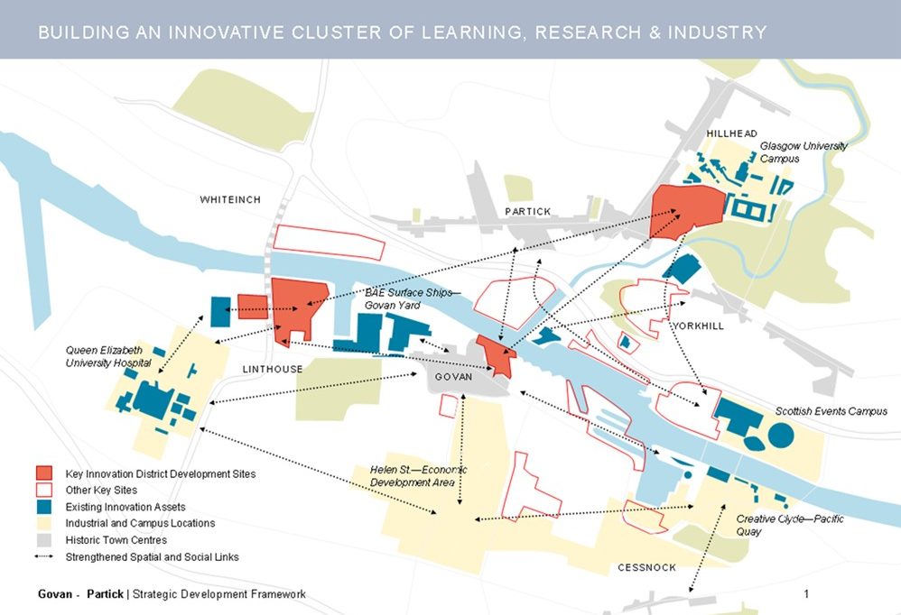
Govan-Partick SDF. (Source: Glasgow City Council).
A central aim of the framework is to reconnect communities with the river through new public spaces, improved walking and cycling routes, and better cross-river links. It also establishes the spatial context for projects such as the Glasgow Riverside Innovation District, positioning Govan town centre as a key part of the long-term transformation of the Clyde waterfront.
In March 2026, funding was secured for a further phase of place-based heritage renewal in Govan. The Govan Heritage Programme comprises £1.525 million from existing Glasgow City Council funding, matched by £1.490 million from the National Lottery Heritage Fund and £1.490 million from Historic Environment Scotland, bringing the total fund to £4.505 million. The five-year programme is expected to leverage approximately £11.5 million of total investment in the local area.
Govan Graving Docks
The Govan Graving Docks, a Category A-listed dry dock complex dating from 1869, are located at the heart of industrial Clydeside. The docks provided critical infrastructure for the repair and maintenance of large vessels at a time when a fifth of the world’s ships were built on the Clyde. As the last remaining dry docks in the city, they are integral to Glasgow’s story and have been described by Historic Environment Scotland as “an outstanding graving dock complex without parallel in Scotland.
The four decades of dereliction following their closure in 1987 have created both a physical and psychological barrier to the river. The site is now a fragile heritage asset, whose industrial character is central to Govan’s identity and wider regional distinctiveness.
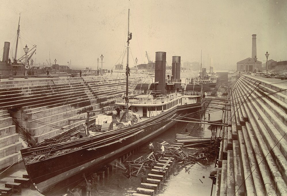
Govan No 3 Graving Dock, looking east in May 1898. (Image credit: Glasgow City Council, Glasgow Museums).
Glasgow City Council is working with key stakeholders to support the sensitive redevelopment of the site as a landmark destination within the city’s emerging River Park. The current regeneration vision, led by site owner New City Vision, moves beyond a housing-led approach towards a mixed-use, heritage-led model. Key elements of the proposal include:
- Riverside Park: A strategic green space designed to address the site’s isolation and create an attractive public destination
- Maritime reactivation: The restoration of Dry Dock No. 1 for commercial ship repair, bringing maritime activity back to the upper Clyde
- Urban densification: The phased delivery of around 300 energy-efficient homes, designed to meet modern environmental standards

Cultural Visitor Attractions: Completing the Riverside Loop. (Image credit: Glasgow City Council, Crown Copyright and database rights 2026 OS AC0000849454).
The project’s value is strengthened by its integration into a wider network of waterfront destinations. The Govan–Partick Bridge (opened in 2024) and a proposed new footbridge to Pacific Quay are critical to overcoming fragmentation in this part of the city. Improved connectivity is expected to support development of nearby vacant sites and to better link Govan’s historic residential core with the digital media and technology cluster around the Glasgow Science Centre.
The Govan project reflects similar regeneration approaches across Europe, including Oude Dokken in Ghent, Refshaleøen in Copenhagen and NDSM Wharf in Amsterdam. These examples show that urban resilience can often be achieved through the sensitive reuse of industrial heritage, rather than its removal. By retaining its original character and materials, Govan can avoid generic waterfront redevelopment and instead create a distinct sense of place that connects its industrial past with a sustainable future.
The redevelopment of the Govan Graving Docks marks an important milestone for Glasgow’s riverside. It demonstrates how regeneration can balance environmental adaptation, social and economic inclusion, and the preservation of maritime heritage. As construction begins, the site is shifting from a symbol of industrial decline to a testing ground for a more inclusive and resilient form of urban development.
HEAD IMAGE | The Clyde Arc Bridge. (Image credit: Glasgow City Council).
╝
NOTES
[1] https://www.glasgow.gov.uk/media/824/River-Clyde-Development-Corridor-Strategic-Development-Framework/pdf/River_Clyde_Development_Corridor_Srategic_Development_Framework.pdf?m=1666864605837/
[2] https://www.glasgow.gov.uk/media/3279/City-Centre-Strategic-Development-Framework/pdf/CC_SDF_-_City_Centre_SDF_Final_May_2021.pdf?m=1677835656130/
[3] https://www.glasgow.gov.uk/media/825/Govan-Partick-Strategic-Development-Framework/pdf/Govan-Partick_Strategic_Development_Framework.pdf?m=1663681944360/
[4] https://www.glasgow.gov.uk/media/1888/Designing-with-Water-Design-Guidance-for-Glasgow-s-River-Corridor/pdf/Designing_with_Water__Design_Guidance_for_Glasgows_River_Corridor_Feb24.pdf?m=1707840100783
[5] https://www.scottishconstructionnow.com/articles/railway-arch-designs-aim-to-open-up-connections-between-glasgow-communities/