╔
Project Overview
Situated along the west bank of the Pearl River in Liwan District, the former Guangzhou Shipyard forms an industrial heritage corridor with the adjacent Guangzhou Steelyards Park (Guanggang Park) – a comprehensive park dedicated to the preservation and adaptive reuse of industrial heritage – and the Guangzhou Paper Mill, creating an unobstructed visual axis toward the Pearl River and the Canton Tower.
The site is isolated by wide arterial roads, elevated expressways, and complex underpasses – Fangcun Avenue to the west, the Ring Expressway to the south, and Hedong Bridge to the north – which prioritize vehicular throughput over pedestrian movement, transforming the former shipyard into an urban “island.” Within these constraints, however, lie extraordinary opportunities. While the planned Line 11/Foshan Line 11 metro interchange unlocks considerable TOD (Transit-Oriented Development) potential, the project faces dual challenges: reconciling the underground station with the adjacent dry dock heritage, and ensuring seamless north-south connectivity beneath the site.
The urban design scheme aims to become the Greater Bay Area’s “Central Activity Zone – Digital Future Port,” integrating commercial offices, retail, cultural exhibition, and parks. The core vision is to blend industrial heritage with modern commerce and waterfront leisure, creating a twenty-four-hour vibrant district that balances historical preservation, urban connectivity, and ecological sustainability. This is not merely a real-estate development but an urban regeneration project that seeks to repair a fractured urban fabric and transform a memorable industrial site into a socially inclusive, economically vibrant, and ecologically resilient place making.
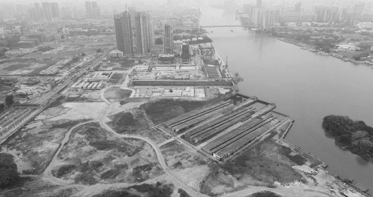
Guangzhou Shipyard – Before Renovation. (© Aedas).
Preliminary Research – Context and Constraints
Historical Evolution of the Shipyard Dry Dock
The dry dock was first constructed in early 1954 with an initial scale of 104 meters in length, 18.3 meters in width, and 7.7 meters in depth. In 1958, Guangzhou Shipyard carried out its first expansion by extending the dock, achieving a length of 145 meters and enabling the construction of 60,000-ton-class vessels. In the late 1970s, to support the conversion project for national scientific research vessels, the dock was extended and expanded again [4].
To increase lifting capacity, a gantry crane with a 55-meter span and 80-ton lifting capacity was installed above the dock. The dock wall and dock foundation structures were also strengthened. After 2000, the dock underwent several upgrade and redesign phases. It was extended westward to a total length of 250 meters, a width of 36 meters, and a depth of 9.35 meters. In this renovation, the dock entrance was changed from an original curved profile to a long straight rectangular form, which is still used today.
Dry Dock Expansion – Evolution Diagram. (© Urban Elephant Architects).

Over more than sixty years of continuous expansion and modification, the dry dock evolved from an early small facility of only a little over one hundred meters into one of the largest shipbuilding infrastructures in South China. It is not only a production facility, but also a living industrial landscape woven together by labor, craftsmanship, and urban memory. Preserved remnants – including tall gantry cranes, rusted shipway tracks, the monumental dry dock, and a gun platform as military heritage – form a physical archive documenting Guangzhou’s path toward modernization.
Yet this cultural mission becomes highly complex due to the physical fragmentation of the urban fabric during the process of urbanization. The under-construction intermodal transfer hub – between Guangzhou Metro Line 11 and Foshan Metro Line 11 – offers outstanding cross-city connectivity, but may also intensify the spatial fragmentation of the district. Meanwhile, surrounding infrastructure – Fangcun Avenue to the west, the Ring Expressway to the south, and Hedong Bridge to the north – creates boundaries that prioritize vehicular movement and are particularly unfriendly to pedestrian accessibility, especially in the east–west direction [3].

Industrial Heritage – Existing Conditions. (© Aedas).
In the initial urban design guidelines for the project site, it is stated that the east-west axis from the Guanggang Park to the Pearl River must remain as unobstructed visual and pedestrian corridors. No above-ground construction is allowed within this green “spine.” The project must build underpass roads and elevated public platforms to reconnect the site to Guanggang Park. The building facades to be approximately muted [4], avoiding heavy materials or vivid colors, so that heritage buildings remain the visibility. These are not relaxed recommendations; they are hard constraints – directly pointing to the core contradiction defining this project.
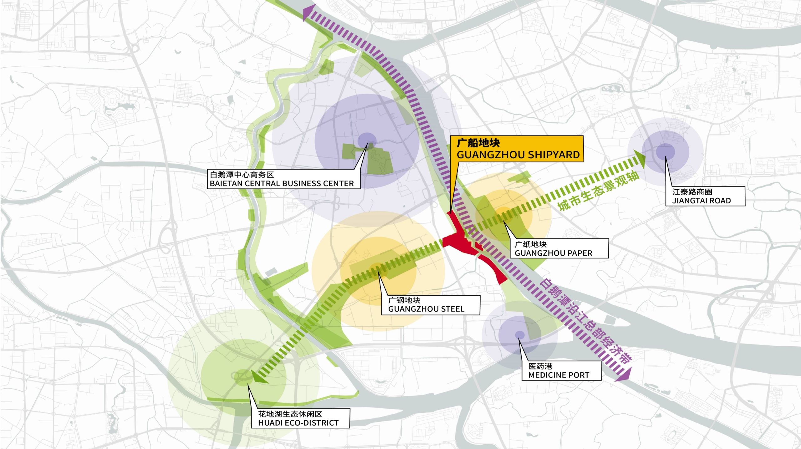
Guangzhou Steelyards–Shipyard–Paper Mill: Urban Axis Context. (© Aedas).
Design Strategies – From Concept to Implementation
The design process faces multiple challenges: sensitive protection of historic remnants, complex functional organization, transportation distribution, urban accessibility, skyline coordination, spatial experience, and economic feasibility. The conceptual design follows a progressive logic – from macro spatial structure to micro-level details.
A decisive starting point is a key guideline: the adaptive reuse of the preserved dry dock must, while respecting its historical appearance, use its recessed topography to accommodate new building volumes. The dry dock is relocated as a cultural facility and directly connected to the semi-underground public plaza to its west through underpass passages. The entire urban design framework – transportation networks, functional zoning, spatial hierarchy, and public realms – is built around this single guideline. This logic reflects an understanding of urban space: urban space is a field of social production, continually reinterpreted and remade. What was once a closed industrial production zone is now reconceived as an open and inclusive domain where diverse social groups can coexist and co-create. The design consciously works to repair the spatial rupture between the city’s mobility and inhabitants’ daily life experience.
Urban Axis
Along the Pearl River coastline, three industrial heritage sites – Guangzhou Steelyard (Guanggang), Guangzhou shipyard, and Guangzhou paper Mill (Guangpaper) – together form a continuous industrial heritage park belt with a total length exceeding 2.5 kilometers. The system uses an east–west central axis and a north–south waterfront shoreline as its backbone, tightly interweaving industrial memory, public space, and urban life.
The Guanggang segment lies to the west. Its axial park stretches for more than 2.5 kilometers with a net width ranging from 100 to 280 meters. The open space area exceeds 28 hectares, serving as a platform for multiple theme parks, including the Blast Furnace themed park, the Steel Museum, the Gas Holder leisure park, a children’s park, and the Guanggang clean-water park.
The Guangzhou Paper Mill segment lies to the east. Its riverside park also exceeds 2.5 kilometers, centered on key nodes including the Guangpaper Culture Park and the Paper Workers’ Life Museum.
Located in the mid-section, the Guangship segment provides approximately 2 kilometers of north–south waterfront shoreline. Its east–west central axis measures about 70 to 75 meters in width, and the open space area exceeds 16 hectares.
All segments follow unified principles for planning control: setback distances for commercial buildings are greater than 100 meters, ensuring continuity and openness of waterfront public space. Among the three sites, the Guangship segment has the most compact central axis—only 70 to 75 meters wide. This means that within the limited green “spine,” the design must be more precise in organizing transportation, landscape, and public activities.
Along the line, the dry dock museum, the shipyard island, and the oil depot heritage park together form a waterfront cultural sequence that echoes the Blast Furnace themed park of Guanggang and the Guangpaper Culture Park. Through connections formed by the central axis and the waterfront shoreline, the three-factory original park system becomes an integrated public space system for industrial heritage – both a historical archive of the city and a future-facing platform for public life.
As a key connector segment between Guanggang and Guangpaper, the Guangship segment’s approximately 2-kilometer riverside park shoreline fulfills a “connecting east and enabling west” spatial mission. The compact axial scale also makes this segment the most challenging portion in the entire system – where spatial organization must be exceptionally precise.
Urban Axis. (© Aedas).

The east-west central green axis extends from Guanggang Park toward the east to the Pearl River waterfront park. It is a multifunctional, composite, continuous open space. The green axis not only carries the functions of landscape and pedestrian corridors but also stitches together multiple key nodes along the line: the performing arts center, the dry dock historical “ark” (cultural memorial museum), the crane relic site, and the central plaza. Metro Line 11 station exits, and transportation hubs intersect here. Through underground pedestrian passages, metro passenger flows are integrated into three-dimensional transfers between the ground level and the second-level platforms.
Layout Program. (© Aedas).
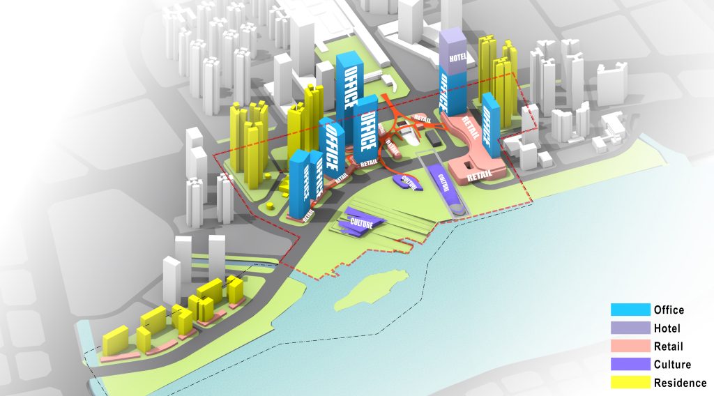
The performing arts center uses the imagery of vessels to respond to the memorial theme. Partial scenes of decommissioned ships are preserved and integrated into the spatial narrative.

Functional Zoning. (© Aedas).
Heritage Activation and Cultural Monument
In the areas adjacent to the site’s inner edge, cultural and commemorative nodes constitute the narrative starting point of the space. The preserved dry dock and tower crane plaza serve as the core anchors of industrial heritage, together with the waterfront cultural and arts cluster and interactive exhibition structures, constructing a timeline that traces the shipyard’s history and translating industrial memory into a perceptible spatial experience.
The transitional zone between the dock and the slipways is the most functionally dense and spatially layered section of the entire waterfront park. Six functional zones are arranged along the north-south direction: Slipway Zone 1, Tower Crane Plaza, Multi-Functional Event Plaza, Library Zone, Waterfront Cultural and Arts Cluster, and Slipway Zones 2 and 3, forming a progressive sequence from industrial heritage to cultural consumption to public activity.
In terms of functional programming, the Tower Crane Plaza features themed events and dry fountains, creating a vibrant public gathering space; the Multi-Functional Event Plaza accommodates festivals and flexible lawn activities, providing support for large-scale events; the Library Zone offers cultural reading and quiet respite; the Waterfront Cultural and Arts Cluster brings together art exhibitions, cultural shops, flower boutiques, public galleries, and unmanned stores, creating a multi-dimensional cultural consumption scene; while the slipway zones at both ends of the sequence are positioned as landscape nodes combining heritage display with ecological viewing. This sequence integrates industrial memory, culture and arts, public social interaction, and natural ecology.
In shaping the commercial atmosphere, the design proposes two dominant models: the “leisure-infused commercial typology” for family-oriented visitors emphasizes slow-paced social experiences and immersive consumption; the “diverse and composite commercial atmosphere” for younger demographics emphasizes trendy experiences and the energetic appeal of water sports. Both serve the overall goal of a 24-hour vibrant district.
The adaptive reuse of industrial heritage is expressed not only in spatial functions but also in site furniture and interactive experiences. Industrial elements are transformed into contemporary light art installations; details of industrial frames are extracted as guardrails, mobile planters, and signage; factory structures are preserved and converted into spatial frameworks or landscape installations. These industrial elements are no longer sealed exhibits but tangible, interactive, and usable everyday objects. Digital interaction technologies – mobile applications providing navigation, hotspot inquiries, and event reminders – extend the experience of the industrial heritage from “viewing” to “participation,” activating the social potential of outdoor spaces through digital media.
Multi-Layered Transportation – Pedestrian-Oriented Network
Building upon heritage activation, establishing a sophisticated multi-layered transport ecosystem is key to making the site truly open to the city.
The site is knitted together by a sophisticated multi-level transport ecosystem. Underground, from ten to five meters below grade, the metro concourse integrates with retail concourses, heritage basements, and sunken plazas. At ground level, controlled vehicular loops and drop-off zones create a calibrated mobility environment. The second-level platform forms a continuous elevated pedestrian loop connecting all major plots, with retail and café frontages along the skybridge. At intermediate levels, between floors three and six, sky-bridges link adjacent buildings, allowing movement between towers without descending to ground level. At tower tops, sky gardens, observation decks, and green roofs serve as shared amenity spaces.
Multi-dimensional Pedestrian System. (© Aedas&ECADI [6]).

Beyond the TOD system formed by the metro interchange and commercial complexes, over twenty vertical cores – elevator clusters, escalator banks, and public staircases – stitch these five layers together. Each core is positioned within a 15-minute walking radius of every plot, ensuring no destination is more than a few minutes from any transport mode. This turns the district into an efficiently operated, fully accessible organic network, where metro arrivals can reach the twentieth-floor office lobby, the waterfront, or the rooftop garden via uninterrupted, weather-protected pathways.
This multi-layered system embodies the principle that accessibility is a form of social equity. By providing barrier-free connections available to all – regardless of age, income, or ability – the design democratizes urban space. The metro, elevated platforms, ground-level walkways, and rooftop gardens become interlocking social spaces where diverse populations converge and interact.

24-hour Corridor. (© Aedas).
Waterfront Greenery and Landscape Experience
Building upon the establishment of three-dimensional accessibility, the landscape system further responds to the topographic characteristics and ecological imperatives of the industrial heritage. With the exception of the slipway areas, the site is largely flat with minimal elevation changes. The three slipways slope downward from south to north, gradually descending toward the waterfront. The overall landscape structure comprises a central axis, two display interfaces (the waterfront interface and the urban interface), and three urban landmarks (the dock, slipways, and tower crane). The continuous viewing waterfront interface and visual axis provide excellent conditions for landscape design [5].
Transitioning toward the waterfront, ecological landscape elements form the second layer. Wetland planting zones, distinctive planting boardwalks, and reflective water features interweave, responding to the hard-edged industrial geometry with soft landscape language, creating a transitional zone that combines ecological restoration with visual amenity.
The primary waterfront interface concentrates water-access and recreational activity nodes. Piers, floating boardwalks, ferry terminals, and kayak launch facilities offer diverse water-based activities, while flexible event lawns, water-curtain viewing terraces, and playful spaces cater to rest, performance, and social needs. These nodes are linked by recreational pathways, forming a continuous, open, and accessible waterfront promenade system.
Commercial outdoor seating elements are interspersed among the nodes, establishing a soft transition between public space and consumer activity, making the waterfront park not only a place for leisure but also an extension of the city’s vibrant economy. Overall, this approximately 2-kilometer waterfront shoreline, with industrial as its foundation, ecological restoration as its medium, and public life as its core, constructs an urban waterfront public space that combines cultural depth, ecological sensitivity, and social vitality.

Shipyard Memory and Greenery. (© Aedas).
Scheme Highlights – Master Plan
Organized around the central green axis as the spatial spine, the design highlights unfold along four interconnected pathways: first, the central plaza and transportation core serve as the pedestrian distribution hub; second, commercial spaces function as the vitality engine; third, community development provides the living foundation; and fourth, the waterfront skyline defines the urban image. These four pathways overlap and reinforce each other to build a continuous, open, and vibrant urban waterfront district.
The Central Plaza and Transportation Core serve as the pedestrian distribution hub of the entire district. The Central Plaza functions as the primary transportation core, channeling pedestrians vertically from the B2 metro concourse to the 3F commercial interfaces, enabling seamless transition between rail transit and commercial consumption. Secondary transportation cores distributed across the site extend via bridges to the southern commercial green ark, opening up additional commercial frontages and effectively enhancing the commercial value and spatial accessibility of surrounding plots. Certain platforms are designated as vehicular drop-off zones, accommodating the convenience of private car travel.

Masterplan. (© Aedas).
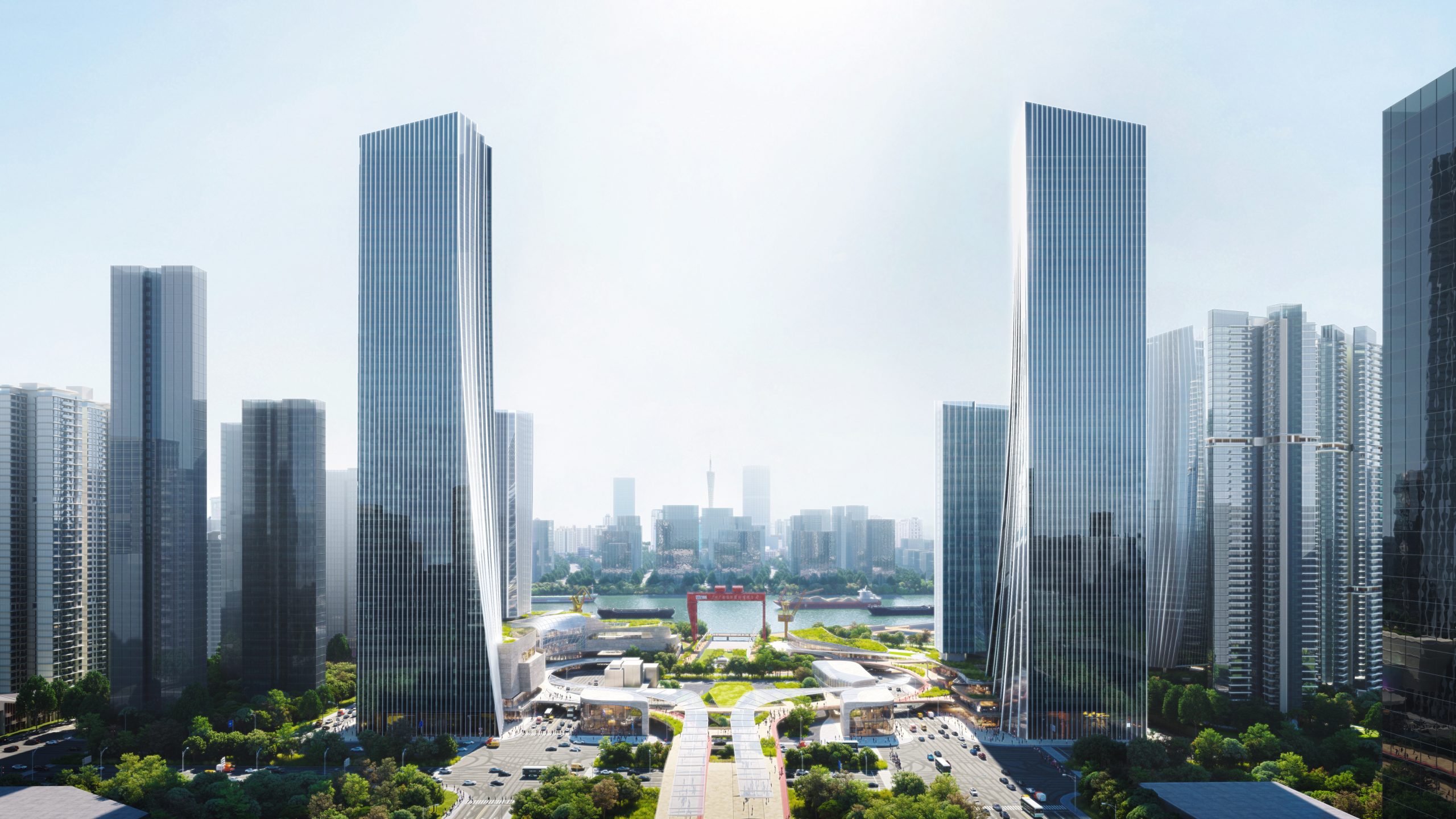
Gataway Towers on the Main Axis. (© Aedas).
Retail follow the concept of “Urban Living Room” and “Green Valley Park,” creating multi-layered, around-the-clock vibrant venues. The central green plaza serves as an urban social stage, connecting street-crossing commercial linkage spaces and the urban elevated river-view garden platform. Highlights include sky markets, rooftop gardens, and river-view landscape corridors, linking urban social spaces with vibrant commercial spaces. Multi-level landscaped activity rooftops incorporate sports themes, while the indoor greenhouse atrium facing the green axis enriches indoor-outdoor spatial permeability. Through tiered terrace designs, commercial spaces open to the city, creating a 24-hour, immersive, nature-oriented consumption experience that continuously draws pedestrian flow toward the waterfront.
Retail Space with High Accessibility. (© Aedas).

Community and lifestyle development emphasizes the concept of pedestrian-oriented open blocks. Community podium rooftop gardens provide green, livable environments, creating a commercial street atmosphere while accommodating daily leisure needs. Bridges and platforms lead southward to the waterfront activity zone and slipway heritage landscape, connecting residents’ daily activities with industrial memory and waterfront scenery, achieving a deep integration of living, leisure, and culture.
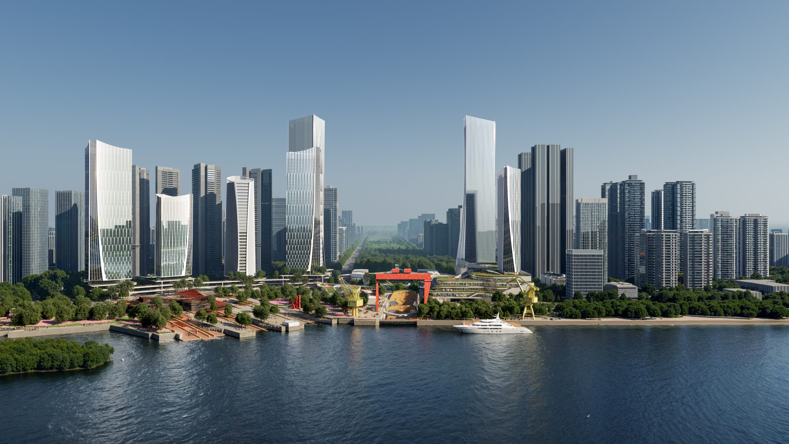
Waterfront Skyline. (© Aedas).
The waterfront skyline is shaped from an urban scale perspective, with building heights progressively adjusted so that the riverside elevation rises step by step from east to west and from the edges toward the center, forming a rhythmic skyline profile. This strategy both optimizes the viewing experience along the river corridor and ensures that, when viewed from the opposite bank, the building massing forms a harmonious visual relationship with the preserved gantry cranes and dock – enabling new architecture and historical marks to engage in dialogue across the urban skyline.
Detailed Design Development Phase
During the detailed design development phase, the transition from concept to implementable project has required continuous technical refinement, supported by the active collaboration between Aedas and the ECADI (East China Architectural Design & Research Institute) project coordination team. A broad range of technical studies and engineering solution have been carried out, including heritage preservation analysis of the dry dock and related structures, excavation support and structural design, vertical design, municipal utility integration, coordination of the metro interface, traffic analysis, slow-traffic system planning, sustainable and green building strategies, code interpretation, and planning approval coordination.
The east-west metro lines initially caused severe underground fragmentation. Through multiple rounds of expert review, mechanical and auxiliary service rooms at the metro-station and dry-dock intersection were relocated, enabling full underground connectivity between northern and southern plots. Ongoing deliberations determine the alignment of commercial connection platforms and the retention or realignment of municipal roadways.

Dock Reuse and Basement Level Connectivity Solutions. (© Aedas&ECADI).
City planning guidelines are continuously updated to harmonize heritage preservation, transit infrastructure, and architectural feasibility. Further refinements respond to government feedback, construction requirements, and engineering constraints, with coordination across infrastructure providers and transport agencies ensuring constructability and operational efficiency.
Conclusions
The Guangzhou Bund Riverside Urban Design is a bold experiment in reconciling industrial memory with urban future. It brings together the shipyard’s historical legacy, the waterfront’s ecological resilience, and the dynamism of a transit-oriented digital hub. The project proves that heritage need not be a constraint – it can be a catalyst, but only if it remains alive, accessible, and woven into people’s daily lives.
Diversity sustains vitality: a mix of uses, scales, and people keeps the district active at all hours. Memory becomes identity: industrial relics are not frozen in time but reinterpreted through use, becoming spaces for gathering, reflection, and discovery. Accessibility ensures inclusion: barrier-free connections open the district to everyone, regardless of age, income, or ability. And resilience grows from stewardship: the waterfront is not just engineered to withstand floods but designed to invite care, engagement, and a sense of shared ownership.
These principles transform this regeneration design from a development project into a place that matters. It shows that urban regeneration, when rooted in the lives of its people, can transcend real estate logic to become genuinely inclusive, resilient, and meaningful. Ultimately, this is a model for industrial waterfronts everywhere-proof that heritage, ecology, and urban life can coexist not as compromises but as strengths, creating a city quarter that is at once global in reach and deeply, authentically local.
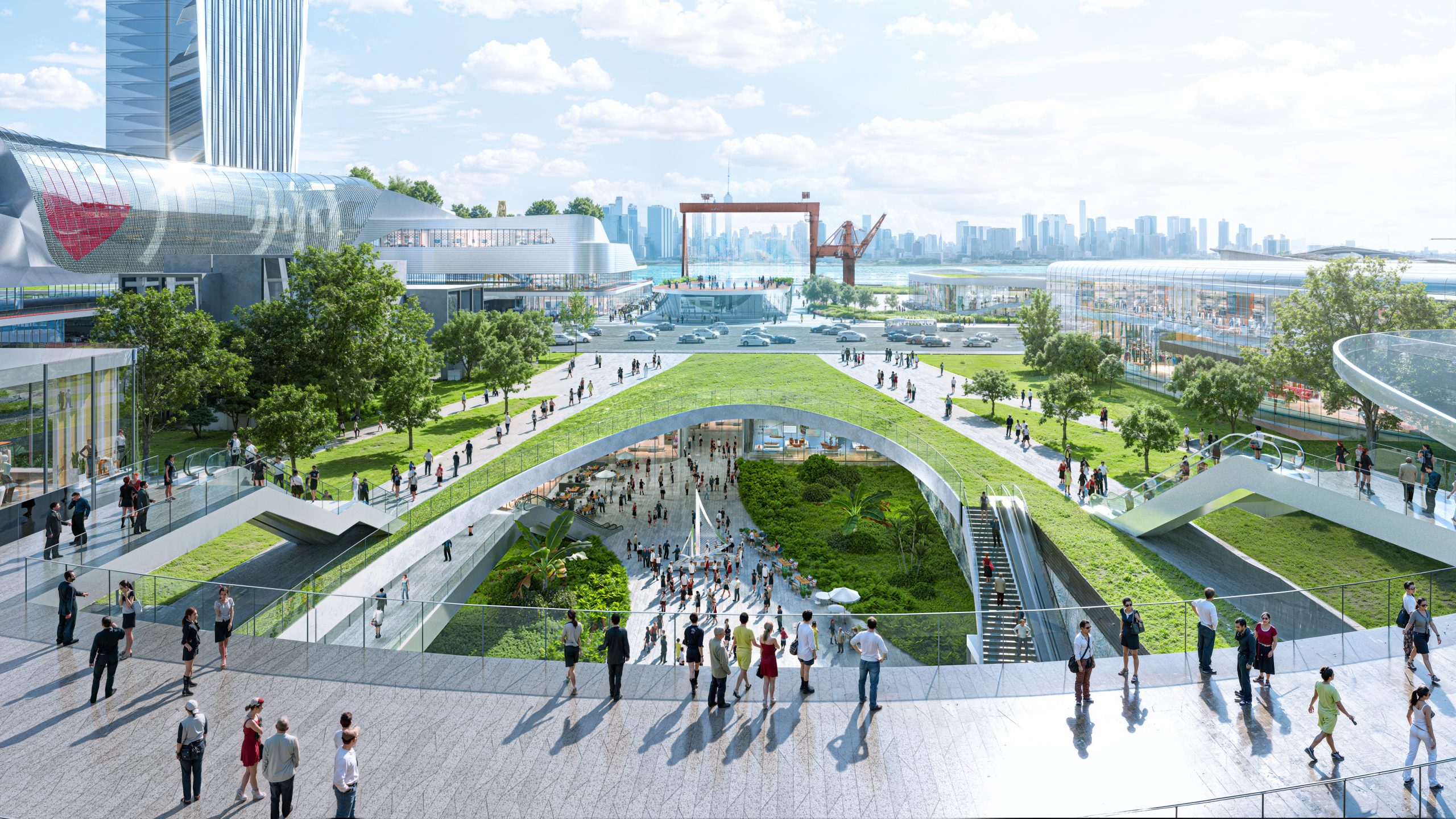
Industrial Heritage, Green Axis, and View Corridor. (© Aedas).
HEAD IMAGE | Connection of Waterfront Developments. (© Aedas). [1]
╝
NOTES
[1] Aedas. Guangzhou Riverside Urban Design: Revitalizing the Industrial Waterfront along the Pearl River[EB/OL]. (2026-03-02).
[2] Liwan District Guangchuan Project (AF0403 Planning Management Unit) Regulatory Detailed Planning and Urban Design Optimization – Urban Design Guidelines for the Guangchuan Site [Z]. Guangzhou Municipal Planning and Natural Resources Bureau, 2022.
[3] Regulations of Guangzhou Municipality on the Protection of Traditional Style Buildings [Z]. 2023-06-13.
[4] Urban Elephant Architects. Guangchuan Phase II, III & IV Site Cultural Heritage Protection Recommendations (Concept Communication Draft)[Z]. 2023-08-22.
[5] GM Landscape. Guangzhou HARBOURCITY: From Industrial Heritage to a Living Waterfront[EB/OL]. (2025-10-27). https://mooool.com/harbourcity-by-gm-landscape.html.
[6] East China Architectural Design & Research Institute Co., Ltd. (ECADI). Overall Technical Control for the Urban Design of the Guangchuan Phase II, III & IV Project [EB/OL]. (2025-06-03).
REFERENCES
A Case Study of the Renovation and Renewal of Old Factories: The Guangzhou Shipyard[J]. Value Engineering, 2018(10).
Halbwachs, M. (1992), On Collective Memory, University of Chicago Press, Chicago.
Jia, C. & Wang, M. (2020), A Study of Industrial Architectural Heritage in Guangzhou, South China University of Technology Press, Guangzhou.