╔
Desarrollo del Puerto de Almería y Proyecto Puerto-Ciudad
Desarrollo del puerto y la ciudad: perspectiva histórica
Development of the Port and the City: Historical Perspective
A lo largo de su historia, el Puerto de Almería ha sido la infraestructura clave de la ciudad y de su zona de influencia. La ciudad de Almería no existiría sin su puerto. En su origen, el abrigo natural que proporciona el Golfo de Almería y, más concretamente, las estibaciones de la Sierra de Gádor en la zona próxima al actual Puerto Pesquero, hicieron de este enclave el asentamiento ideal de Fenicios, Romanos y Árabes. Es de esta última etapa de la que datan las primeras infraestructuras conocidas construidas por el hombre. Entonces era la ciudad la que estaba amurallada para defenderse de las amenazas que provenían del mar. Posteriormente la ciudad se funde con el puerto-fondeadero y a principios del siglo XX se construyó el dique de abrigo actual.
Throughout its history, the Port of Almeria has been the key infrastructure of the city and its area of influence. The city of Almeria would not exist without its port. Originally, the natural shelter provided by the Gulf of Almeria and, more specifically, the foothills of the Sierra de Gador in the area near the current Fishing Port, made this enclave the ideal settlement for the Phoenicians, Romans and Arabs. It is from this last stage that the first known infrastructures built by man date. Then it was the city that was walled to defend itself from the threats that came from the sea. Later the city merged with the port-anchorage and at the beginning of the 20th century the current breakwater was built.
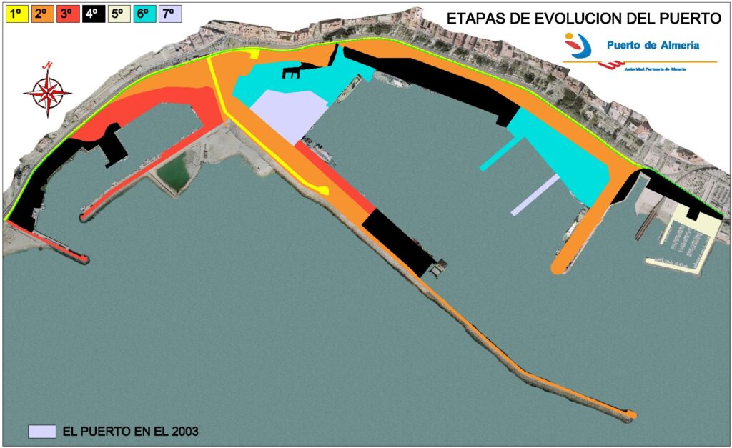
Etapas históricas del desarrollo del Puerto de Almería.
Historical stages of the development of the Port of Almeria.
En la imagen se puede observar el proceso evolutivo del puerto de Almería, desde la construcción del arranque del dique de poniente hasta la más reciente terminal de pasajeros, con 2 pantalanes y 5 rampas Ro-Ro. Puede observarse el déficit de superficie y la imposibilidad de ganar más terreno a costa de la dársena. En la imagen también se observa cómo en 2003 se iniciaba la ampliación hacia el mar.
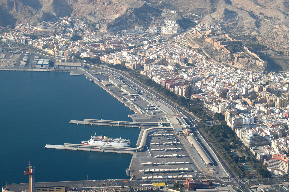
El devenir de la ciudad y el puerto han ido siempre íntimamente ligados y, en esta dilatada historia, la ciudad disfrutó del puerto como de una zona urbana más. Una de las primeras actuaciones Puerto-Ciudad se inició en Almería en el siglo XIX y no fue otra que el Parque Nicolás Salmerón, tras el derribo del primitivo baluarte de San Luis y la parte de la muralla que discurría paralela al puerto. Ya bien entrado el siglo XX se construyó la actual Vía Parque (la principal vía de acceso a la ciudad desde la A7) íntegramente en terrenos portuarios. El resultado puede verse en la imagen siguiente: entre la valla del puerto y el antiguo cantil del muelle había poco más de 50 metros, insuficiente para llevar a cabo una adecuada explotación portuaria.
El auge del tráfico de pasajeros a principios del siglo XXI llevó a la Autoridad Portuaria a ganar terreno al mar para disponer de la superficie y los atraques necesarios para dar servicio a este importante tráfico que ha convertido al Puerto de Almería en una frontera de la UE. Y, de paso, al superar el millón de pasajeros al año, ha puesto a Almería en el mapa de las Redes Transeuropeas y en la Red Global de la UE.
The image shows the evolutionary process of the port of Almeria, from the construction of the start of the Western Breakwater to the most recent passenger terminal, with 2 piers and 5 Ro-Ro ramps. The surface deficit and the impossibility of gaining more land at the expense of the harbour basin can be observed. The image also shows how in 2003 the expansion towards the sea began.
The future of the city and the port have always been intimately linked and, in this long history, the city enjoyed the port as just another urban area. One of the first Port-City actions began in Almeria in the 19th century and was none other than the Nicolas Salmeron Park, after the demolition of the primitive bastion of San Luis and the part of the wall that ran parallel to the port. Well into the 20th century, the current Park Road (the main access road to the city from the A7) was built entirely on port land. The result can be seen in image_02: there was little more than 50 meters between the port fence and the old dock cliff, insufficient to carry out adequate port operations.
The boom in passenger traffic at the beginning of the 21st century led the Port Authority to reclaim land from the sea in order to have the necessary surface area and berths to service this important traffic, which has turned the Port of Almeria into an EU border. And, by the way, by exceeding one million passengers a year, it has put Almeria on the map of the Trans-European Networks, which is not insignificant given that, if this traffic did not exist, Almeria would have been left out of the Mediterranean Corridor and the EU Global Network.
Parque Nicolás Salmerón y Vía Parque. Nueva Zona de Pasajeros.
Nicolas Salmeron Park and Park Road. New Passenger Area.
Así pues, el tráfico más importante del Puerto de Almería es, hoy por hoy, el de pasajeros con el Norte de África y es, por tanto, la principal fuente de ingresos del mismo. Este tráfico se ubica en la zona más próxima a la ciudad. El siguiente tráfico en orden de importancia es el de las exportaciones de yeso, material del que la provincia es una de las principales productoras mundiales, y se opera en la zona más alejada de la ciudad, situada en el área de expansión del puerto hacia el mar. También una gran parte de las materias primas y manufacturadas de la industria y del sector hortofrutícola de la provincia entran por el puerto de Almería.
Sin embargo, a lo largo del siglo XX estos tráficos no fueron significativos. El tráfico principal siempre fue el de mineral de hierro procedente de las minas de Alquife, en la provincia de Granada. Este tráfico desapareció por diversas causas y el último barco de mineral de hierro atracó en 1996, en la zona Este del puerto, en el conocido como Cable Francés. Anteriormente se realizó la carga en el famoso Cable Inglés, construido entre 1904 y 1906. Esta histórica infraestructura constituye un paradigma de la ingeniería industrial española en su categoría de inmueble-máquina, siendo declarado Bien de Interés Cultural en 1988. Es uno de los principales símbolos de identidad de la ciudad de Almería y ha sido restaurado recientemente convirtiéndolo en un paseo que arranca en el Parque de la Estación (proyecto redactado por el arquitecto Ramón de Torres). Esta puede considerarse como nuestra primera gran actuación Puerto-Ciudad del siglo XXI.
Africa and is, therefore, its main source of income. This traffic is located in the area closest to the city. The next traffic in order of importance is that of plaster exports, a material of which the province is one of the world’s leading producers, and it operates in the area furthest from the city, located in the expansion area of the port towards the sea. Also a large part of the raw and manufactured materials of the industry and the fruit and vegetable sector of the province enter through the port of Almeria.
However, throughout the 20th century these traffics were not significant. The main traffic was always that of iron ore from the Alquife mines, in the province of Granada. This traffic disappeared for various reasons and the last iron ore ship docked in 1996, in the eastern part of the port, in what is known as the French Cable. Previously, the load was carried out on the famous English Cable, built between 1904 and 1906. This historic infrastructure constitutes a paradigm of Spanish industrial engineering in its category of property-machine, being declared an Official Asset of Cultural Interest in 1988. It is one of the main symbols of identity of the city of Almeria and has recently been restored, turning it into a promenade that starts in the Station Park (project designed by the architect Ramón de Torres). This is considered our first major Port-City intervention of the 21st century.
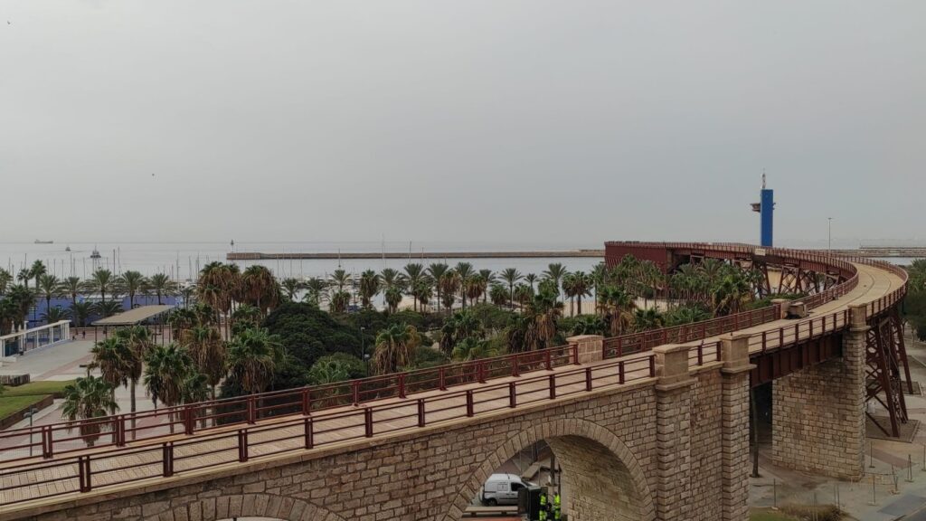
Vista desde la ciudad del Cable Inglés convertido en Paseo Peatonal.
View of the English Cable from the city converted in a Pedestrian Walkway.
Es precisamente toda esta zona, que en su día servía al mineral de hierro y que cuenta con una dársena deportiva, la que requiere una actuación de carácter prioritario, y es en la que se desarrolla el proyecto Puerto-Ciudad que aquí se presenta. Y es aquí donde hay que poner el máximo esfuerzo para dignificarla, modernizarla y, algo no menos importante, conectarla peatonalmente de una manera adecuada y fluida con el centro urbano. No debemos olvidar que cuando se operaba con el mineral de hierro e incluso cuando se construyó el puerto deportivo (a finales del siglo XX) esta era una zona marginal y deslavazada de la ciudad. Sin embargo, el desarrollo de la ciudad la ha convertido en el centro geométrico del frente litoral. Pero su accesibilidad desde el centro urbano sigue marcada, en cierto sentido, por su antiguo uso.
El proyecto Puerto-Ciudad también incluye el Muelle de Levante y una ampliación del mismo. El Muelle de Levante es el más próximo a la ciudad y está ya abierto al uso ciudadano con solo algunas restricciones cuando atraca en él un crucero, que es su principal uso. Dada su situación, es el muelle ideal para este tipo de tráfico, de ahí que su ampliación e incorporación al proyecto tenga un valor importante para la misma. También tendrá como valor añadido su uso como zona de ocio y multifuncional, no solo para la ciudad, sino también para el Puerto. Ofrecerá servicios al tráfico de cruceros y pasajeros, de los que hoy día se adolece. La espera para embarcar será mucho más agradable y hará al puerto más competitivo y atractivo para los pasajeros tanto de los cruceros como para los de las líneas regulares.
Finalmente, hay que resaltar que, cuando hablamos de Actuaciones Puerto-Ciudad, no debemos olvidar que éstas deben ir ligadas a zonas portuarias que han quedado o van a quedar a corto plazo en desuso para la actividad propiamente portuaria. De lo contrario lo que estaríamos hablando, en último extremo, es de desmantelar el puerto como tal. En el apartado siguiente se describe la ampliación del puerto que se está acometiendo en la actualidad y que permitirá a medio y largo plazo continuar con el proceso de integración Puerto-Ciudad.
It is precisely this entire area, which in the past served iron ore and has a Marina, which requires priority action, and is where the Port-City Project presented here is being developed. And it is here where the maximum effort must be made to dignify and modernize it and, not least importantly, connect it on a pedestrian basis in an adequate and fluid way with the urban center. We should not forget that when the iron ore was operated and even when the Marina was built (at the end of the 20th century) this was a marginal and disjointed area of the city. However, the development of the city has made it the geometric center of the coastline. But its accessibility from the urban center is still marked, in a certain sense, by its former use.
The Port-City Project also includes the Levante Pier and an its extension. Levante Pier is the closest to the city and is already open to public use with only a few restrictions when a cruise ship docks there, which is its main use. Given its location, it is the ideal wharf for this type of traffic, hence its expansion and incorporation into the project is of significant value to it. It will also have the added value of being used as a leisure and multifunctional area, not only for the city, but also for the Port. It will offer services to cruise and passenger traffic, which it currently lacks. Waiting to board will be much more pleasant and will make the port more competitive and attractive for both cruise and regular line passengers.
Finally, it should be noted that, when we speak of Port-City Actions, we must not forget that these must be linked to port areas that have been or will be left in disuse for port activity in the short term. Otherwise, what we would be talking about, ultimately, is to dismantle the port as such. The following section describes the expansion of the port that is currently being undertaken and that will allow the medium and long term to continue with the Port-City integration process.
Ampliación del puerto y desarollo
Port Expansion and Development
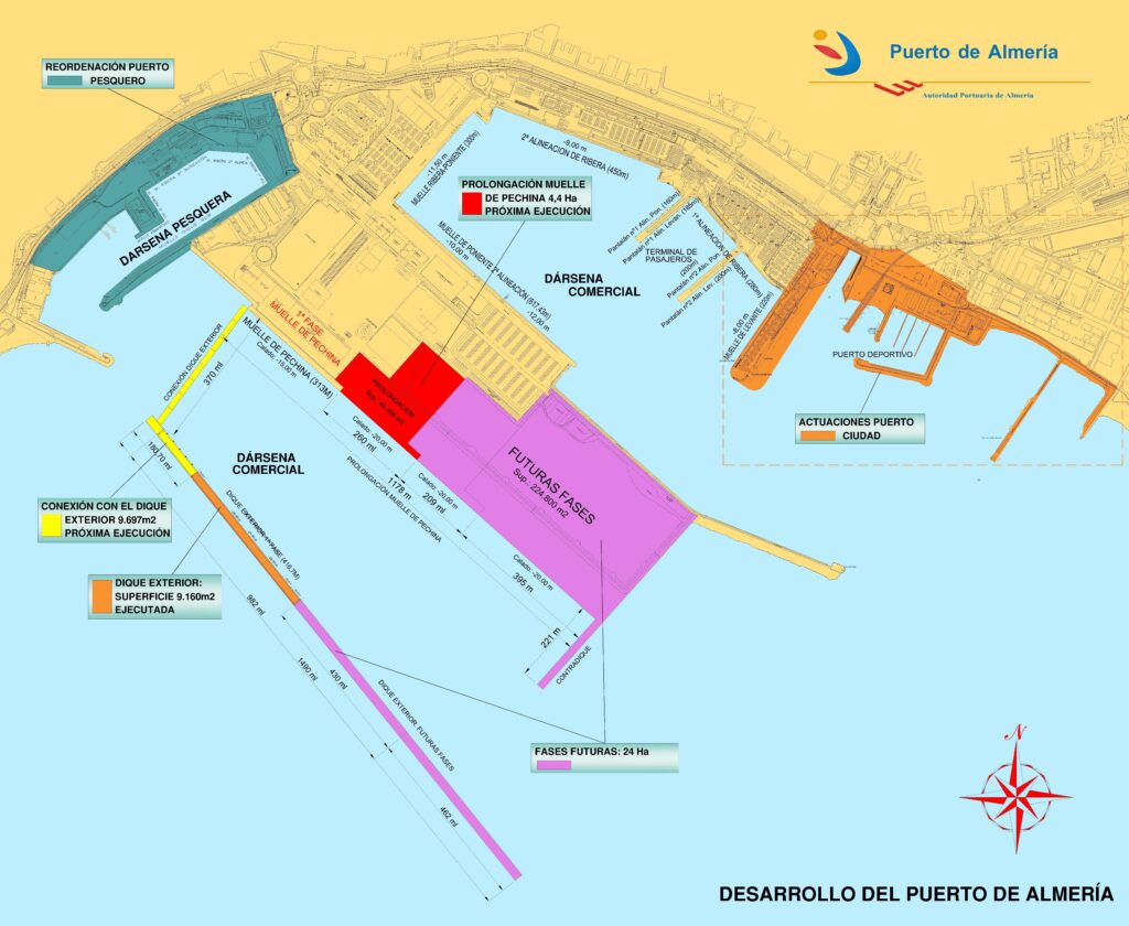
El puerto de Almería, dada la falta de superficies y muelles, una vez que la dársena comercial ha quedado completamente saturada tanto en tierra como en agua (primera imagen), se planteó el Desarrollo de Poniente como la gran apuesta de futuro para convertir al Puerto de Almería en un puerto moderno y preparado para los retos del transporte marítimo del siglo XXI. Prácticamente, en su desarrollo final, se trata de un nuevo puerto que servirá para atender las demandas futuras de tráficos previsibles y potenciales. De momento, lo construido hasta la fecha, ha servido para incrementar sustancialmente el tráfico de graneles sólidos y mejorar las condiciones medioambientales del mismo alejando los acopios de la ciudad.
The Port of Almeria, given the lack of surfaces and docks, once the commercial dock has been completely saturated both on land and in water (first image), the Western Development was raised as the great future commitment to convert the Port of Almeria in a modern port prepared for the challenges of maritime transport in the 21st century. In fact, in its final development, it is a new port that will serve to meet the foreseeable and potential future traffic demands. So far, what has been built to date has served to substantially increase solid bulk traffic and improve its environmental conditions by moving stockpiles away from the city.
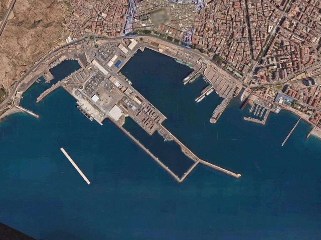
Planta Actual del Puerto de Almería. De izquierda a derecha: Dársenas Pesquera, Comercial y Deportiva. En la parte sur, la ampliación de Poniente con la primera fase del Dique de Abrigo.
Current Plan View of the Port of Almeria. From left to right: Fishing and Commercial Ports, and Marina. In the southern part, the Western Development with the first stage of the Outer Breakwater.
Este desarrollo fue planteado desde la base de las necesidades actuales y futuras pero también teniendo en cuenta muy seriamente las posibilidades reales de acometerlo desde el punto de vista económico-financiero y funcional. Para ello se ideó un desarrollo en fases que fueran operativas y permitieran financiar las siguientes. No teníamos ni la capacidad financiera ni los tráficos reales que justificaran un nuevo puerto con una inversión de más de 200 millones de euros, con lo que hubo que echarle grandes dosis de imaginación y realismo por igual.
La primera fase consistió en una línea de atraque (Muelle de Pechina) paralela a la actual del Muelle de Poniente, a 450 m. de éste, con una longitud de 313 m. Con la ejecución de esta primera fase se generó una explanada de 167.000 m2. El muelle no tenía abrigo (contamos con el “abrigo natural original”) y su operatividad no superaba el 85%. Además se necesitó contar con un sistema de previsión meteorológica y un protocolo de actuación asumiendo ciertos riesgos calculados y previsibles.
Fue una apuesta que permitió, además, dar servicio a la construcción del gaseoducto con Argelia, lo que generó ingresos para financiarla y poder acometer la construcción de un primer tramo del nuevo dique de abrigo: pudimos “archivar” los protocolos y los riesgos calculados, incrementando sustancialmente la operatividad del muelle.
También se ha ejecutado el perímetro de lo que en un futuro será toda la explanada correspondiente a las siguientes fases del desarrollo exterior. Se ha realizado parte de la explanada que delimita dicho perímetro con la ejecución de un dique en talud de escollera que discurre paralelo al actual Dique de Poniente hasta que quiebra su alineación para morir contra el mismo (lo que llamamos “la piscina”). Dentro del recinto así formado, se va generando explanada según la demanda y necesidades del puerto, pudiéndose llegar a generar hasta 400.000 metros cuadrados de superficie de tierra. La “piscina”, además, se va rellenando “gratuitamente” con los productos admisibles de vaciados de obras que se realizan en el entorno de la ciudad. Un ejemplo han sido las obras de soterramiento ferroviario que han aportado más de 200.000 metros cúbicos.
Actualmente, el incremento del tráfico de yeso ha promovido la redacción del proyecto de prolongación del muelle en otros 260 metros y un calado de 18 metros para dar servicio a esta creciente demanda de exportación de graneles. El presupuesto es 23 millones de euros.
This development was raised from the basis of current and future needs but also taking into account very seriously the real possibilities of undertaking it from the economic-financial and functional point of view. For this, a development in stages was devised that would be operational and allow the following to be financed. We had neither the financial capacity nor the real traffic to justify a new port with an investment of more than 200 million euros, so we had to use imagination and realism alike.
The first stage consisted of a berthing line, called Pechina Dock, with a length of 313 metres and which runs parallel to the current Western Dock of 450 metres. With the execution of this first stage, an esplanade of 167,000 m2 was created. The new dock had no shelter, other than the original natural shelter, which limited operations to less than 85% of working days In addition, it was necessary to have a weather forecast system and an action protocol assuming certain calculated and foreseeable risks.
It was a commitment that also made it possible to provide a service for the construction of the gas pipeline with Algeria, which generated income to finance it and to be able to undertake the construction of the first section of the new breakwater: we were able to “archive” the protocols and the calculated risks, substantially increasing operations at the new dock.
The perimeter of what in the future will be the entire esplanade corresponding to the following stages of exterior development has also been executed. Part of the esplanade that delimits this perimeter has been built with the execution of a breakwater embankment dam that runs parallel to the current Western Breakwater until it breaks its alignment to die against it (what we call “the pool”). Within the enclosure thus formed, an esplanade is generated according to the demand and needs of the port, being able to generate up to 400,000 square meters of land surface. The “swimming pool”, in addition, is filled “free of charge” with the admissible products emptied from works that are carried out in the city’s surroundings. An example has been the railway burial works that have contributed more than 200,000 cubic meters.
Currently, the increase in plaster traffic has promoted the elaboration of the project to extend the quay by another 260 meters and a draft of 18 meters to serve this growing demand for bulk exports. The budget is 23 million euros.
Desarrollo de Poniente completo. Zona de actuaciones Puerto-Ciudad.
Full Western development. Port-City Area.
También se ha redactado el proyecto de la conexión terrestre del dique de abrigo para poder operar también en dicho dique. En la actualidad es inviable dar servicio a la demanda de plataformas en reparación o estancia prolongada sin esa conexión con tierra. Los calados, de más de 22 metros, pueden hacer muy competitivo este muelle adosado al dique para este tipo de tráficos.
Finalmente, podemos concluir que, con la configuración completa, se ofrecen calados de muelle que van desde los 16 metros de la primera fase a más de 20 metros en la fase final. Ello permitirá dar servicio a cualquier barco de última generación y prepara al Puerto de Almería para el futuro a corto, medio y largo plazo.
The project for the land connection of the breakwater has also been elaborated in order to also be able to operate in this breakwater. Currently it is unfeasible to service the demand for platforms undergoing repair or prolonged stay without this connection to land. The depths of more than 22 meters can make this dock attached to the breakwater very competitive for this type of traffic.
Finally, we can conclude that, with the complete configuration, quay depths ranging from 16 meters in the first stage to more than 20 meters in the final stage are offered. This will allow any state-of-the-art ship to be served and prepares the Port of Almeria for the future in the short, medium and long term.
Proyecto puerto-ciudad
Port-City Project
El proyecto, ya redactado, abarca desde el Muelle de Levante hasta el espigón que limita con la Playa de El Zapillo. Se sitúa dentro de la zona de servicio del Puerto de Almería, tal y como se contempla en la Delimitación de Espacios Portuarios, identificada como Zona de Usos Puerto-Ciudad. Se ha compartimentado en fases que habrán de acometerse en función de las disponibilidades presupuestarias y los acuerdos con los concesionarios actuales del Puerto Deportivo. La primera fase será la Ampliación del Muelle de Levante, a acometer en el próximo año 2023.
Además de la ampliación del muelle hacia la zona de la Rambla, también se aborda la adecuación de la cara interna del muelle actual para dar un correcto servicio al tráfico de cruceros, dado el estado de deterioro que presenta. El Muelle de Levante está construido a base de bloques de mampostería y es el más antiguo de la dársena comercial del Puerto de Almería. Dada su tipología y antigüedad, era conveniente mejorar y garantizar su operatividad para continuar disponiendo de este tráfico, muy atractivo para la ciudad. Para ello se ha de proceder a consolidar tanto la superestructura como el paramento, así como dotarlo del equipamiento necesario.
The project, already elaborated, covers from the Levante Pier to the breakwater that borders the El Zapillo Beach. It is located within the service area of the Port of Almeria, as contemplated in the Delimitation of Port Areas, identified as the Port-City Use Zone. It has been divided into stages that will have to be undertaken depending on budget availability and agreements with the current concessionaires of the Marina. The first stage will be the expansion and development of the Levante Pier, to be undertaken in the next year 2023.
In addition to the expansion of the quay towards the Rambla area, the adaptation of the internal face of the current quay to provide a correct service to cruise traffic, given its state of deterioration, is also addressed. The Levante Dock is built from masonry blocks and is the oldest in the commercial dock of the Port of Almeria. Given its type and age, it was convenient to improve and guarantee its operability to continue having this traffic, which is very attractive for the city. For this, it is necessary to proceed to consolidate both the superstructure and the facing, as well as provide it with the necessary equipment.
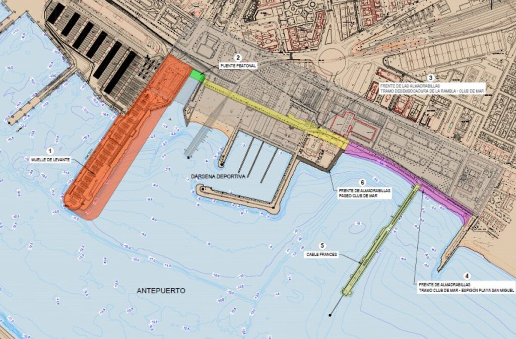
Fases del Proyecto Puerto-Ciudad.
Port-City Project Stages.
Con la actuación en el Muelle de Levante, se creará una zona multifuncional que dará cabida a espacios de ocio, comerciales, culturales y administrativos, con la idea de que sea utilizado por la ciudad día y noche. Será un gran revulsivo para la revitalización del centro de la ciudad y su casco histórico y además potenciará el tráfico de cruceros dando servicio al tráfico de pasajeros del puerto. La necesidad de ampliar la superficie de tierra hacia la Rambla sin invadir su visual, es necesaria dada la escasa anchura actual del dique. Esta ampliación permitirá crear un nuevo atraque para pequeños cruceros y embarcaciones de recreo de grandes esloras en una zona atractiva para dicho tráfico por los servicios que se pondrán a disposición y por su entorno, con un carácter netamente urbano.
With the intervention at the Levante Pier, a multifunctional area will be created that will accommodate leisure, commercial, cultural and administrative spaces, with the idea that it will be used by the city day and night. It will be a great catalyst for the revitalization of the city center and its historic quarter and will also boost cruise traffic by serving the port’s passenger traffic. The need to extend the land surface towards the Rambla without invading its line of sight is necessary given the current low width of the dam. This extension will allow the creation of a new berth for small cruise ships and large pleasure boats in an attractive area for this traffic due to the services that will be made available and its surroundings, with a net urban character.
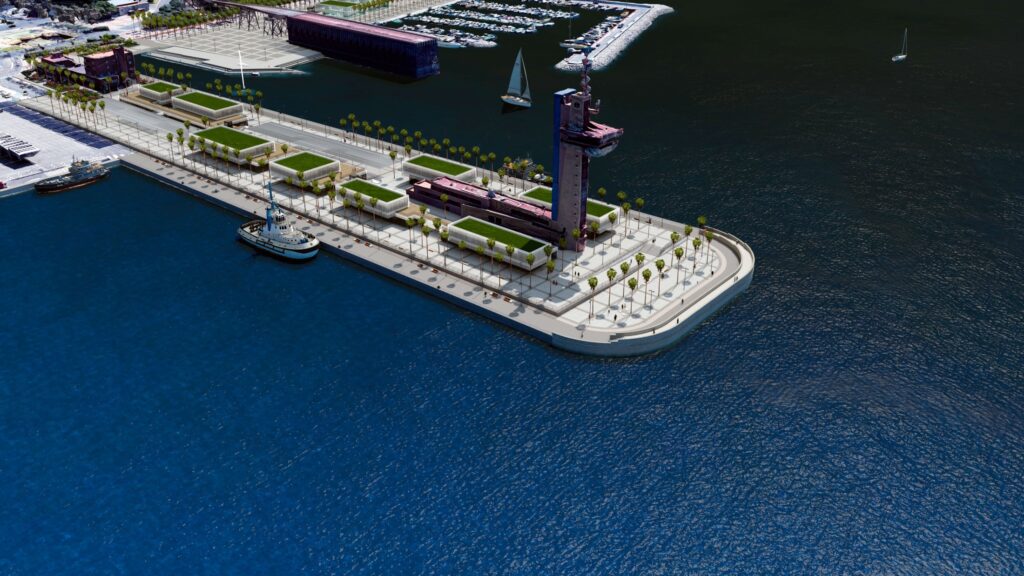
Ampliación del Muelle de Levante.
Extension of the Levante Pier.
Se dotará de los calados e infraestructuras que posibiliten su uso adecuado tanto para el tráfico de cruceros como para el uso libre ciudadano. Para ello se ha ideado crear un aparcamiento semi-soterrado (sin invadir el nivel freático) que permita dar el servicio propio y necesario de un aparcamiento, pero que, al mismo tiempo, eleve la zona urbana de acceso libre, independizándola de las restrictivas normas del tráfico de cruceros. Este diseño en dos niveles permite además mejorar sensiblemente (por elevación de entre 1.5 y 2 metros) las vistas experimentadas por los ciudadanos que, dispondrán de unas inmejorables panorámicas, por un lado del Cable Inglés y, por otro, de la Alcazaba y el casco antiguo de la ciudad, así como de la dársena del puerto.
Esta infraestructura se financiará con fondos públicos mediante un convenio de colaboración y cesión de espacios libres con el Ayuntamiento de Almería, que ejecutará las obras a través de la financiación acordada con la Junta de Andalucía. El presupuesto de la primera fase de las obras asciende a 15 millones de euros.
It will be equipped with the depths and infrastructures that enable its adequate use both for cruise traffic and for free citizen use. So, it has been devised to create a semi-underground parking area (without invading the water table) that allows for the proper and necessary service of a parking area, but at the same time, elevates the urban area with free access, making it independent of the restrictive regulations of cruise traffic. This design on two levels also makes it possible to significantly improve (by elevation of between 1.5 and 2 meters) the views experienced by the pedestrians, who will have unbeatable panoramic views, on one side of the English Cable and, on the other, of the Alcazaba and the old town of the city, as well as of the docks of the port.
This infrastructure will be financed with public funds through a collaboration agreement and transfer of free spaces with the Almeria City Council, which will carry out the works through the financing agreed with the Regional Governement (Junta de Andalucía). The budget for the first stage of these works amounts to 15 million euros.
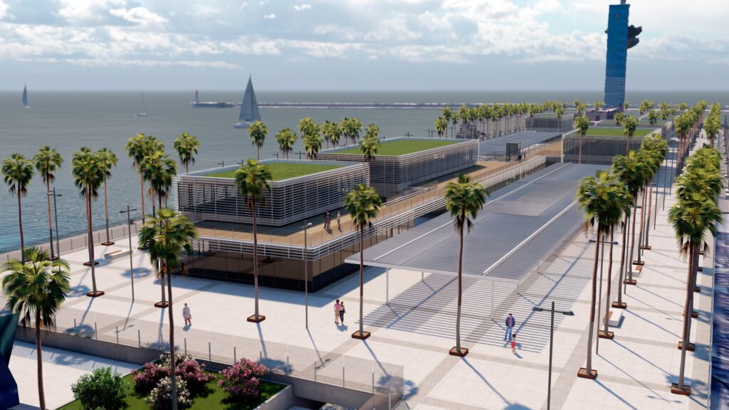
Vista del Muelle de Levante desde la ciudad.
View of the Levante Pier from the city.
El resto de actuaciones arquitectónicas y de urbanización serán por cuenta de la iniciativa privada mediante concesión administrativa que otorgará en concurso la Autoridad Portuaria.
La redacción del proyecto ha sido financiada y dirigida por la Autoridad Portuaria de Almería en continuo consenso con el Ayuntamiento de Almería, que decide las fases en las que se ejecutará. El equipo redactor ha sido la UTE formada por Proes-Estudio 7, con la colaboración de Góngora Arquitectos. Las imágenes arquitectónicas que se muestran son una propuesta orientativa del resultado final. Será a través de un concurso y con financiación privada lo que definirá el resultado final. Para ello, se está tramitando el correspondiente Plan Especial de Ordenación Urbanístico.
Sin una financiación pública de las infraestructuras básicas, la posibilidad de contar con una inversión privada es prácticamente nula, ya que el alto coste haría inviable una inversión mínimamente rentable del total de la actuación.
The rest of the architectural and urban development actions will be carried out by private initiative through an administrative concession that will be awarded by the Port Authority in competition.
The elaboration of project has been directed and financed by the Port Authority of Almeria in continuous agreement with Almeria City Council, who decides the phases in which it will be executed. The drafting team has been the joint formed by Proes-Estudio 7, with the collaboration of Gongora Arquitectos. The architectural images shown are an indicative proposal of the final result. It will be through a contest and with private financing that will finally define the final result. To this end, the corresponding Special Urban Development Plan is being processed.
Without a public financing of the basic infrastructures, the possibility of having private investment is practically nil, since the high cost of these infrastructures would make a minimally profitable investment of the total action unfeasible.
Panorámica del borde litoral.
Panoramic view of the coastline.
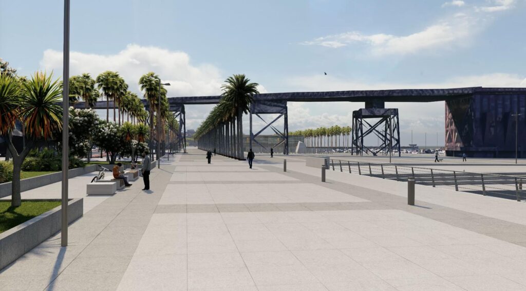
Pero el proyecto ha ido más allá y ha abordado intervenciones a lo largo de todo el frente marítimo de Las Almadrabillas que mejoran su accesibilidad al borde del mar y permiten la apertura a la ciudadanía del puerto deportivo. Se trasladarían usos tales como el actual varadero que podrían ser atendidos en otras zonas portuarias, como puede ser el Puerto Pesquero y otras zonas que están en estudio. Todo ello de común acuerdo con los concesionarios actuales.
La idea fundamental es que el borde marítimo sea, en todo su frente, accesible a la ciudadanía sin excepción. Para ello se han estudiado tanto la planta como el alzado, de manera que pueda regularizarse su frente (incluyendo el dique de abrigo del Puerto Deportivo). Se han tenido en cuenta las condiciones de escorrentía y de calado en cada zona y, en consecuencia, los niveles de rebase admisibles que determinan la la geometría de la estructura del borde urbano en cada uno de los tramos del mismo.
But the project has gone further and has addressed interventions along the entire Las Almadrabillas sea front that improve its accessibility to the edge of the sea and allow the Marina to be opened to the public. Uses such as the current shipyard would be transferred, which could be served in other port areas, such as the Fishing Port and other areas that are under study. Always in agreement with the current dealers.
The fundamental idea is that the maritime border is accessible to citizens without exception, along its entire front. For this, both the plan and the elevation have been studied, so that its front can be regularized (including the breakwater of the Marina). All this taking into account the conditions of runoff and depth in each zone and, consequently, the admissible levels of overtopping that determine the defining geometry of the seawall in each of its sections.
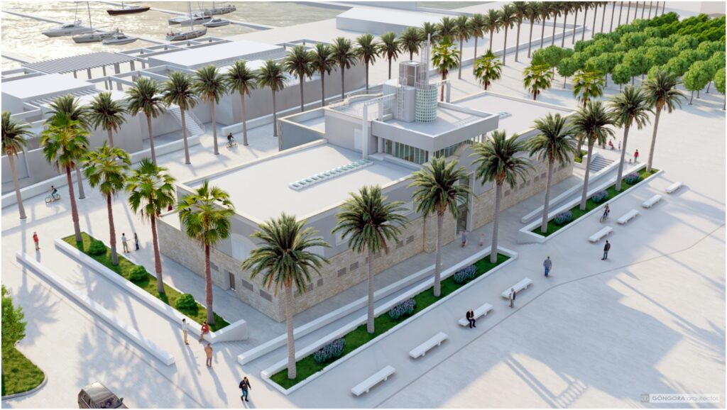
Remodelación del antiguo Edificio del Centro de Actividades Náuticas.
Remodelling of the old Building of the Nautical Activities Center.
Un ejemplo podemos verlo en la siguiente imagen en la que aparece la situación final del antiguo edificio del Centro de Actividades Naúticas, hoy en desuso. Este edificio es uno de los más singulares de la ciudad y, sin embargo, las sucesivas pavimentaciones del entorno han acabado por dejarlo bajo la cota del Paseo principal. Con la nueva remodelación se demuele el paseo actual y se hace una nueva pavimentación a cota con el frontal del edificio. El edificio se pretende concesionar como centro de ocio y actividades culturales mediante concurso.
An example can be seen in the following image, which shows the final situation of the old building of the Nautical Activities Center, now in disuse. This building is one of the most unique in the city and, however, the successive pavements of the surroundings have ended up leaving it below the level of the main Seaside Promenade. With the new remodelling, the current promenade is demolished and a new paving is made at level with the front of the building. The building is intended to be concessioned as a center for leisure and cultural activities through a public tender procedure.
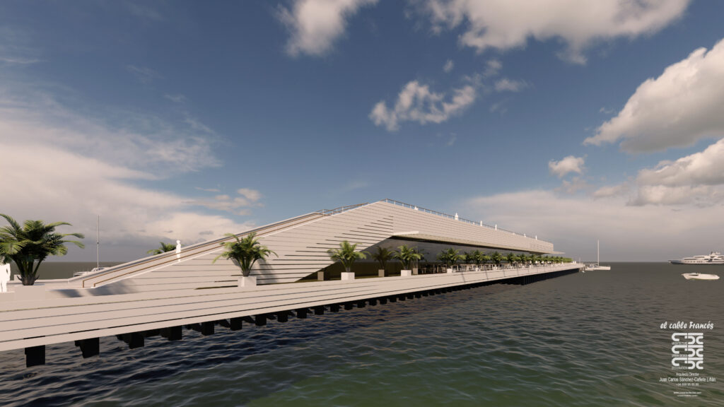
Propuesta de intervención en el Cable Francés.
Proposal for intervention in the French Cable.
También se ha incluido en el proyecto la reutilización del Cable Francés como zona de acceso peatonal pública, compatible con usos de ocio a desarrollar por la iniciativa privada, también mediante concesión administrativa. Ha sido necesario analizar la situación estructural del Cable Francés y proponer medidas de seguridad, tanto estructurales como funcionales. Se presenta aquí una idea de Sánchez-Cañete Arquitectos [2]. Es solo orientativa, y la compatibilización público-privada se consigue con dos niveles en altura que recuerdan el perfil original del Cable Francés con su cargador sobresaliendo de la plataforma del cable.
En conjunto se ha diseñado una adecuada interconexión longitudinal de todas y cada una de las zonas, dotándolas de pavimentación, servicios y mobiliario urbano, que estén acordes con la centralidad urbana que representa actualmente el entorno. Esto implica la necesidad de ensanchar el actual puente peatonal de la Rambla, de forma que el Paseo Marítimo actual conecte en todo su ancho con el Muelle de Levante.
Also included in the project is the reuse of the French Cable as a public pedestrian access area, compatible with leisure uses to be developed by private initiative, also through an administrative concession. It has been necessary to analyze the structural situation of the French Cable and propose both structural and functional security measures. An idea by Sanchez-Cañete Arquitectos [2] is presented here. In this idea, public-private compatibility is achieved with two height levels that recall the original profile of the French Cable with its original charger protruding from the cable platform.
As a whole, an adequate longitudinal interconnection of each area has been designed, providing them with paving, services and urban furniture, which are in accordance with the urban centrality that the environment currently represents. This implies the need to widen the current pedestrian bridge of the Rambla, so that the current Seaside Promenade connects its entire width with the Levante Pier.
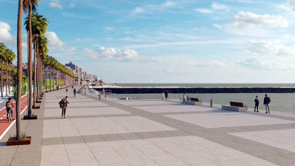
El Paseo Marítimo desde el nuevo puente peatonal. Al fondo el Cable Inglés.
The Seaside Promenade from the new pedestrian bridge. In the background the English Cable.
Finalmente, se han estudiado diferentes soluciones para conectar peatonalmente y de manera fluida el centro urbano de la ciudad con la zona de actuación Puerto-Ciudad y, en definitiva, el Puerto [2]. Estas soluciones exceden el alcance y extensión de este artículo. No obstante, pueden consultarse en la página web de la Autoridad Portuaria de Almería en donde también se puede visualizar la conferencia completa de la Jornada organizada por RETE en la ciudad de Almería. En elle se presentó el proyecto completo junto con ideas para los accesos [3].
Finally, different solutions have been studied to connect the urban center of the city with the Port-City area of action and, ultimately, the Port [2].These solutions exceed the scope and length of this article. However, they can be consulted on the website of the Port Authority of Almeria where the full conference of the Conference organized by RETE could be visualized, in which the complete project was presented along with the accesses [3].
IMAGEN INICIAL | Vista general de la Zona Puerto-Ciudad. Anteriormenete Zona de Carga de Mineral de Hierro: en primer plano el Cable Inglés; arriba a la izquierda el Cable Francés; en el centro la Dársena Deportiva.
HEAD IMAGE | General view of the Port-City area. Formerly iron ore loading zone. In the foreground English Cable. Above left the French Cable. In the center the sports dock.
╝
Video
Video
El Proyecto Puerto-Ciudad consensuado con el Ayuntamiento, presentado por el Puerto de Almería en una jornada organizada por RETE, está disponible en el siguiente enlace:
The Port-City Project agreed with the City Council, presented by the Port of Almeria in a conference organized by RETE, is available at the following link:
Notas
Notes
[1] https://apalmeria.com/proyecto/video-cable-frances/
[2] https://apalmeria.com/proyecto/propuestas-de-conexion-puerto-ciudad/
[3] https://apalmeria.com/puerto-ciudad/proyectos-puerto-ciudad/