Urban Undergrounds
The history of Rotterdam is marked by spatial expansion. Its initial location was on the north side of the Maas river, but from the 1860’s onwards port developments leapt over the river (Meyer, 2016: 84) and continued along the south bank. Containerization in the 1960’s led to further, rapid expansion westwards, where container districts and offshore ports further increased the separation between ports and cities.
These horizontal expansions were intertwined with issues of depth, as is easily illustrated by continued efforts to deepen and dredge the Nieuwe Waterweg after its construction in the 1870’s, the carving out of new harbors from the polders on the south bank (Hein and van de Laar, 2020: 267) and later westwards in the new land captured from the sea, Europoort. With a surface of 310 hectares, the Waalhaven on the south bank is the largest dug harbor in the world today, and the Ertsoverslag Europoort CV (EECV) allows ships with a hull of 24 meters. In-depth dimensions of built infrastructure are thus key for thinking about the past, present and future of Rotterdam.
The importance of verticality has been emphasized in histories of urbanization more broadly. One reason for this is that historically, cities have often been built on the basis of extracting from the underground. For example, Paris and its underground have taken shape through a long history of extracting limestone for building projects (Pike, 2018; Macfarlane, 2019: 138). From the late 18th century onwards, the resulting caverns became used as burial sites (catacombs) (Graham, 2016) and in the mid-19th century, during the great transformations led by the urban planner Haussmann, the modern sewer system was constructed underground (Gandy, 2014).
Underground Infrastructure
In urban terrains, the underground has become an important space for more than sewers and cables. Underground metro systems, tunnels under rivers, underground cruise terminals (Shanghai, Hamburg, Galata, Istanbul) and shopping malls are major examples of the other facilities located underground (Hein, 2016).
In Rotterdam too, the underground provides fertile terrain for public works. For underground infrastructure projects in Rotterdam, however, the relationship with water is pertinent. Situated in the polder landscape of the Western part of the Netherlands, Rotterdam sits below sea level. It even includes the lowest place of the Netherlands – 6 meters below sea level – within its urban area. This could have been a reason to hesitate going underground, but water above ground played a role in deciding otherwise. The Nieuwe Maas divides Rotterdam in two, and the need for mobility raised the question of how (and where) to cross it: by ferry, bridge or tunnel. Tunnels are much more expensive and complicated to build, but a strong lobby promoted them in Rotterdam: the powerful shipping companies feared that bridges would either limit the height of ships or would cause delays in transport traffic on the river (Berkers et al., 2019: 17-18). The width of the Nieuwe Maas (ranging from 265 – 465 meters) also played a role in pushing underground solutions to cross-river mobility.
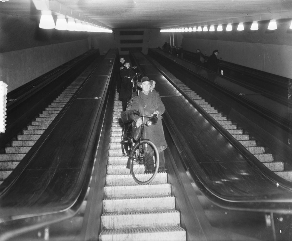
The project of building the Maastunnel started in 1937, and – despite the start of the German occupation and the bombing of Rotterdam on May 14th 1940 – the tunnel project was completed in 1942. This underground infrastructural work is interesting for its technological challenges, but also for how it highlights the social history of Rotterdam. It shows clearly which lobbies were involved; how the governors of the city negotiated with state authorities, notably Rijkswaterstaat; how the interests of laborers traveling to the harbors on the south bank were weighted; and how different forms of mobility – cars versus bicycles – were taken into account and catered for. As the Netherlands’ first underwater road tunnel, the Maastunnel was primarily built to facilitate car mobility (Ovenden, 2019:122). However, there was also a significant lobby, consisting of employers in the harbor and a Dutch interest group for cyclists (Algemene Nederlandsche Wielrijders-Bond, A.N.W.B.), promoting additional tunnels for bicycles. In the end, an option was chosen with two extra tunnel tubes, for bicycles and pedestrians, a solution car-lobbyists agreed giving their expectation that once cycling would become obsolete these tunnels could be adapted for car traffic (Berkers et al. 2019: 18).
In Rotterdam, as in other metropolitan areas, underground transport infrastructure often serves multiple purposes, as the metro-lines illustrate. Renovations of the Metro station of Wilhelminaplein, located at the ‘Kop van Zuid’, aimed to extend its functionality to include a business center, apartment buildings and recreation facilities (Durmisevic, 1999: 240). Moreover, urban planners have started to prefer the integration of underground and above ground spatial functions. Despite the lowlands’ challenges, high population density gave an important push towards going deeper in the Dutch Randstad. To build more compactly, the city’s vertical line could be used more efficiently by fully integrating the underground with the aboveground lay-out and characteristics (Durmisevic, 1999: 239). Of course, building under an existing built environment necessitates integrated planning; a street-plan of a city is a major determinant for how subsurface infrastructure and surface worlds are tied together and vertical mobilities organized.
Beursplein is an excellent example of integrating underground and overground spaces for the purposes of mobility and shopping. Shopping underground in extended annexes of the tube station is brought in sync with the shopping area above ground, significantly – or maybe better notoriously – called ‘Koopgoot’, the ‘Buying gutter’ [1].
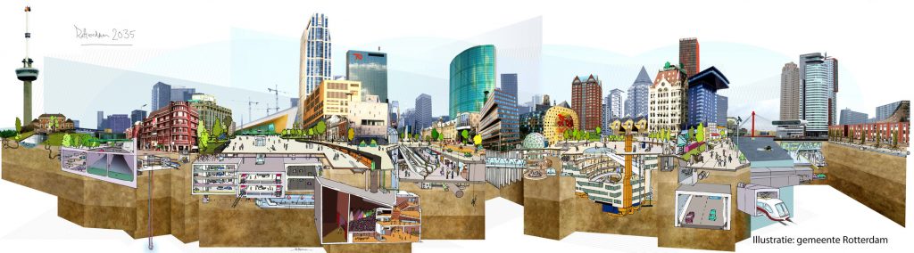
In this area of Rotterdam, underground infrastructural works have been so prominent that an agreement was made in 2019 to leave the underground to rest as much as possible for the coming years [1]. The intensity of vertical developments in the city of Rotterdam are portrayed in an e-book published by the Municipality entitled ‘De Ondergrond van Rotterdam’.
Underground as Archive
In the landmark shopping market, the Markthal, vertical connections are highlighted explicitly. The unique horse-shoe-shaped structure, designed by the famous architect Winy Maas, has eleven stories housing offices and apartments.
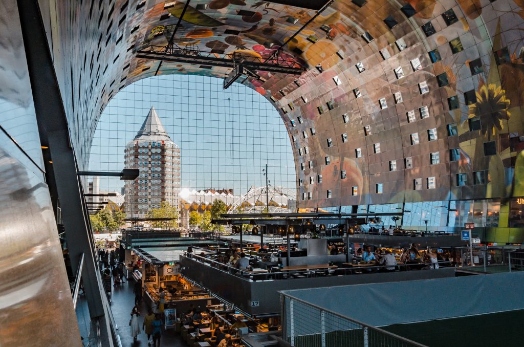
On ground level we find the market stalls and shops, but the basement holds a large car park. The Markthal itself has been built on top of an eleventh century village (near the river Rotte). Prior to the building of this infrastructure, archeological digs had been carried out, whose key finds are displayed in a museum called De Tijdtrap, The Time Stairs. The display follows the descending line of the escalator: the further down, the older the objects on display. Visitors literally walk back in time as they descend to their cars after shopping (Ovenden, 2020: 125).
This fantastic display exemplifies the temporal dimension of the underground of Rotterdam.

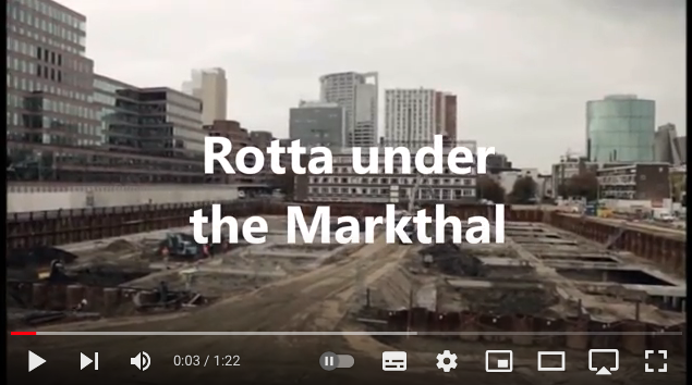
The YouTube link presents the story of the exhibition and the archeological finds. On the lowest level, -4 of the parking lot, the story of the predecessor of Rotterdam, Rotta, is told. Some 950 years ago, the first farmers settled on the raised areas along the river Rotte, a bog river which flowed into the Nieuwe Maas. In the course of time, the land flooded more and more frequently and the farmers were unable to maintain their grounds for cultivation. Eventually, the site submerged temporarily, until the 13th century when new waterworks (notably the rotte-dam) were constructed, which mark the beginning of Rotterdam as we know it today.
The Tijdtrap demonstrates how a whole history of settling and farming lies hidden beneath our feet in Rotterdam.
Nowadays, whenever large infrastructural works are envisaged and planned, archeological digs and research need to be carried out to inspect the underground for archeological remains [2]. In Rotterdam this is the task of the Bureau Oudheidkundig Onderzoek van Gemeentewerken Rotterdam (Office for Archeological Research of Public Works in Rotterdam) [3]. The acronym of this municipal service is BOOR, which means ‘to drill’ in Dutch.
The YouTube film mentioned above is one of the outputs of BOOR. So is the very nice book entitled “Ontdekt! Vijftig jaar archeologie in Rotterdam en Omgeving” (Carmiggelt and Trierum, 2010). Again, the title contains a pun: the Dutch word for “discover” is literally un-cover (ont-dekt). The book details finds from fifty infrastructural sites, for instance the sluices found on the construction site of the underground railway, the Willemsspoortunnel, in the early nineteen nineties (idem: 86-7). The flooding in the 12th century detailed in the Tijdtrap was followed by (re)building of dykes along the Nieuwe Maas. The high dam which was built in the Rotte marks the beginning of the city of Rotterdam. The height of the dam provided protection, but also inhibited the necessary discharge of water from the Rotte into the Nieuwe Maas. Sluices, with doors which opened and closed in sync with the tides, were built to regulate water’s entry and egress. These excavations detail how Rotterdam’s past was marked by water challenges and notably the issue of finding the right levels.
Verticality and Futures
Vertical dimensions of water have defined Rotterdam’s past and are also influential for its present and future. Han Meyer (Meyer, 2021) describes how the Rotterdam port region is part of the Rhine-Meuse delta, a system of rivers regulated by dikes, dams, locks and weirs. Dredging has been a central technique for creating this, which he calls a “hydraulic machine”. Meyer (Meyer, 2016: 110-115) analyses the cultural values which became attached in the Netherlands to in-depth dredging, a key technology for digging canals and reclaiming land. He describes, for example, the book “Dredge, Drain and Reclaim: The Art of a Nation”, written in 1948 by the water engineer van Veen (Van Veen J., 2012).
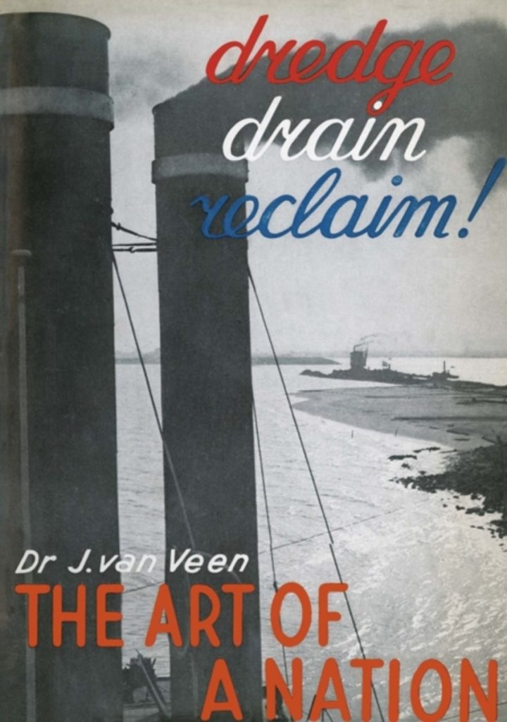
The book aimed to provide an inspiring narrative for a nation coming out of war. The heroic description of how to work with water and reclaim lands would swing the mood from defeat into proud nation building. Canalization and controlling water became a metaphor for victory and mastery.
In the current situation, in which we are confronted with the sinking land and rising water, however, the value of dredging needs reconsideration. Meyer raises this issue in the light of the upcoming celebration of 150 years of the Nieuwe Waterweg in 2022. Together with architects and organizations for nature conservation, he argues that continued dredging of the Nieuwe Waterweg is not sustainable. The attempts to master nature have clearly occurred at the expense of it. Rather than artificial channeling and confining water surfaces on the basis of in-depth technologies, we should work towards more collaborative interweaving of natural and technological processes, he writes. And this leads him to a case for the un-deepening of the Nieuwe Waterweg.
This reconsideration of the values attached to the vertical digging of waterways resonates with new currents in the study of navigation dredging, notably in geography and anthropology. These analyses interrogate the implications of deep harbor building for accommodating megaships. The first focus of concern is place-based and looks into ecological effects for deltas, quite similar to Meyer’s arguments regarding the Rhine-Meuse delta. Secondly, the concerns extend to larger global processes: since deep-water dredging projects aim to facilitate rapid worldwide developments in shipping and the logistics industry, localized dredging is bound up with global-political economic processes (Carse and Lewis, 2020: 3). In addition to serious concerns about localized ecological systems, this in-depth technology raises questions about global redistribution of economic benefits. How do deep harbor developments and shipping channels reshape global networks, and how is digging deep expressive of the belief in worldwide economic growth?
Clearly, redressing future values for people, planet and profit requires vertical perspectives on port regions and how these are implicated in wider in-depth geopolitics [4]. The case of Rotterdam brings home how a view from below is needed to understand and guide movements from past and present to the future of Rotterdam and also for other port cities around the globe.
Head Image | Kop van Zuid. Wilhelminapier with World Port Center and Erasmus Bridge Skyline Rotterdam. (© Leon Willems; Source: Port of Rotterdam Authority, 2020).
Notes
[1] In this area of Rotterdam, underground infrastructural works have been so prominent that an agreement was made in 2019 to leave the underground to rest as much as possible for the coming years, a so-called Graafrust agreement (https://www.evides.nl/over-evides/nieuws/2019/9-partijen-tekenen-voor-graafrust-coolsingel; https://www.rotterdam.nl/bestuur-organisatie/archeologie/).
[2] A law introduced in 2007 obliges all Dutch municipalities to take care of its archeological heritage (Carmiggelt and van Trierum, 2010).
[3] https://www.rotterdam.nl/bestuur-organisatie/archeologie/.
[4] A term we originally coined for the study of gold mining practices in Ghana (Luning and Pijpers, 2017).
References
Berkers, E. et al. (2019), Cycling Cities: The Rotterdam Experience. Foundation for the History of Technology.
Carmiggelt, A. and Trierum, M. van (2010), ‘Ontdekt!’ Rotterdam: Bureau Oudheidkundig Onderzoek van Gemeentewerken Rotterdam.
Carse, A. (2014), Beyond the big ditch: Politics, ecology, and infrastructure at the Panama Canal. MIT Press.
Carse, A. & Lewis, J. A. (2020), ‘New horizons for dredging research’, WIREs Water, 7(6).
Durmisevic, S. (1999) ‘The future of the underground space’, Cities. Elsevier, 16(4), pp. 233–245.
Gandy, M. (2014), The fabric of space: Water, modernity, and the urban imagination, The Fabric Of Space: Water, Modernity, and the Urban Imagination. doi: 10.1080/2325548x.2016.1187511.
Graham, S. (2016), Vertical: The city from satellites to bunkers. Verso Books.
Hein, C. (2016), ‘Modernist urban visions and the contemporary city’, Joelho, (7).
Hein, C. and van de Laar, P. T. (2020), ‘The Separation of Ports from Cities: The Case of Rotterdam’, in European Port Cities in Transition. Springer, pp. 265–286.
Luning, S. and Pijpers, R. J. (2017), ‘Governing access to gold in Ghana: In-depth geopolitics on mining concessions’, Africa, 87(4).
Macfarlane, R. (2019), Underland: A Deep Time Journey. Penguin UK.
Meyer, H. (2016), De staat van de Delta: Waterwerken, stadsontwikkeling en natievorming in Nederland. Uitgeverij Vantilt.
Meyer, H. (2021), Blue Paper #2: Re-considering the Rhine mouth as a smart hydraulic system. https://www.portcityfutures.nl/news/blue-paper-2-re-considering-the-rhine-mouth-as-a-smart-hydraulic-system/.
Ovenden, M. (2019), Underground Cities: Mapping the tunnels, transits and networks of our cities. White Lion Publishing.
Pike, D. L. (2018), Subterranean cities: The world beneath Paris and London, 1800–1945. Cornell University Press.
Van Veen, J. (2012), Dredge Drain Reclaim: The Art of a Nation. Springer Science & Business Media.