Maritime flows have been carrying the bulk of global trade for centuries. They can be seen as a crucial benchmark of the vitality of the world economy as a whole and of its components such as port cities and maritime regions at various scales. Being one of the oldest forms of human interaction, maritime flows are good indicators of economic circulation and a useful tool to “take the pulse of world trade and movement”. It is well-known that most global cities are or have been global ports; however, the few existing empirical works providing a clear snapshot of global maritime flows at different historical periods were more interested by other aspects such as past climatic conditions, the diffusion of knowledge through shipping, the environmental impacts of shipping, bioinvasions, and the measurement of a composite global urban accessibility index including maritime flows.
Applying a maritime perspective to world history and world regionalization thus remains an unaccomplished project although the maritime foundations of the world economy need not being demonstrated any further. It has been somewhat forgotten with the radical competition of air transport for passenger flows, the drastic social and urban impacts of changing port and shipping technologies, and the growing preference for other flows in academic research. More likely in this perspective are studies of other global networks such as those shaped by airlines, multinational firms, trade, migration, knowledge, and communication flows.
Context of the project
Although there is only one data source providing detailed information, on a weekly basis and on a global level, about flows of merchant vessels between ports of the world, it has, surprisingly, never been used or mapped systematically. There is only one mention of this source in the whole academic literature, by the geographer Henry Rees in 1955, where he promoted the usefulness of Lloyd’s List “as a source for port study in school”. It is only in the late 1990s that such a large-scale approach was proposed in order to reveal the polycentric organization of global maritime flows, based on Lloyd’s Voyage Record. This pioneering work was pushed further a decade later when mapping the changing spatial pattern of North Korea’s port activities and overseas connections over the 1985-2005 period, the liner shipping network and port hierarchy of Northeast Asia, the Atlantic and the world, the analysis of regional subsystems in this network, its combination with airline flows forming a global urban hierarchy, and the intermingling of various commodity types in the multigraph. Other studies of the kind have emerged in parallel, mostly focusing on graph properties and using newly available sources to study recent flows [1].
Undoubtedly, the potential offered by Lloyd’s List to analyze the long-term evolution of cities and their global interactions remains by far unexplored. It is, perhaps, the only source capable of documenting in concrete terms globalization, regionalization, and urbanization processes over nearly three hundred years. How is the current distribution of port activity path-dependent, and can we identify key evolutions at local and global levels? How does port activity reflect wider aspects of economic life under different contexts? Have some port cities been more resilient than others over time?
Milestones of the project
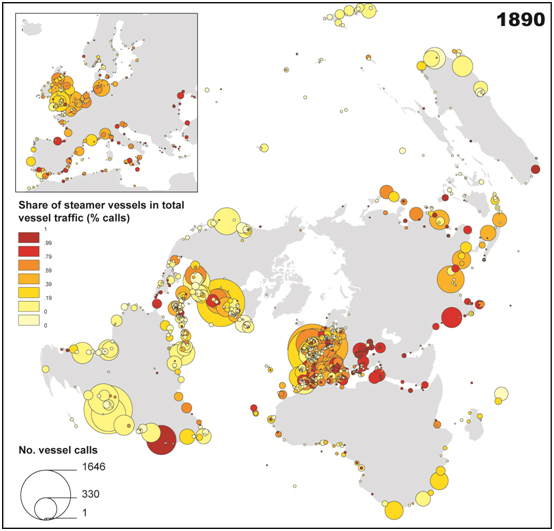
The first research direction is the elaboration of a geomatics platform with strong emphasis on Geographic Information Systems (GIS) methods of data representation and analysis. Flows will be represented in diverse forms such as 2D and 3D representations on a world map and sphere using various cartographic projections. This is in itself an innovation of the project that has many pedagogical outcomes. Each port of call is a location (node) and each voyage is a link between two or more ports of call at a given period. Each vessel circulation creates both a “chain” (successive stops) and a “complete graph” (all stops connected directly and indirectly). The global maritime database is thus built from successive port-to-port matrices to be analyzed as a non-planar, weighted, and directed graph on various levels of node aggregation (e.g. port, port city, country, macro-region, continent) and where nodes and links have several attributes based on vessel characteristics (i.e. flag nationality, vessel size and type) and movements (i.e. duration, length, frequency). Two maps are offered here as preliminary results obtained from the extraction of one single issue published in 1890.
 Port hierarchy and share (%) of steamer traffic in 1890.
World shipping activity in the late nineteenth century is very much concentrated at a handful of large ports, among which London, Liverpool, New York, but also Buenos Aires and the Rio de la Plata. Marseilles, Genoa, and Barcelona dominate the Mediterranean, while Hamburg is the largest of the North European gateways. Steam vessel traffics are concentrated, however, along the Europe-Asia routes, following the opening of the Suez Canal in 1869 and in a context of Europe’s growing colonial interests towards the East Indies.
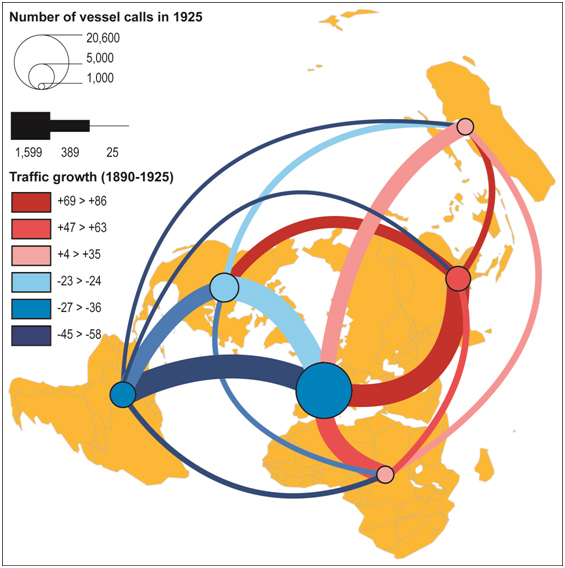
 Interregional shipping routes in 1890.
Between 1890 and 1925, the major dynamic is clearly a shift from the Atlantic to the Pacific. Europe-Latin America has declined by 47% while Europe-Asia has grown by 69% and Asia-North America by 77%. Factors include the advent of steam shipping along those routes backing colonial advances in Africa and Asia, the demise of Argentina as a major rival of North Atlantic powers, and the rapid industrialization of Japan.
At the global level, the project will measure the size of the network (i.e. number of nodes and links, total tonnage) as well as the changing structure of flows through various statistical and network analytical tools. Classic concentration measures (e.g. Gini coefficient, HHI) will be completed by network-specific ones such as those provided by graph theory, social network analysis, and complex networks. The changing size and properties of the network will be one first evidence of the globalization process and its ongoing trend of transformation. The capacity of flows to reflect and/or anticipate major global events will be examined in terms of the network’s robustness and vulnerability, with reference to major works on scale-free / small-world networks and their cumulative dynamics. Preferential attachment can be tested to explore whether newly added ports generally connect to already established and larger ports. Innovation diffusion in the maritime and ports sector has been highly selective at different stages; many ports were dropped from the network, but new ports were also created or reactivated. Other global indicators can be produced such as the average duration and distance of links so as to verify the concept of time-space shrink in world exchanges. Simulation experiments will be tested with the help of other institutions in order to forecast future changes and confront past dynamics with some models of network evolution, but this is not a core objective and competency of the principal investigator. Another important dimension of the analysis will be the search for coherent substructures in the network, with reference to the buoyant research field on clusters and communities. Various methods such as single linkage analysis, hierarchical clustering, modularity, trajectory analysis, block modeling, and structural equivalence will reveal in different ways the emergence and resilience of subsystems in the pattern of flows. The idea is to map the cores and the peripheries as well as to examine the influence of various proximities in their internal and external links (e.g. spatial, commercial, political). The role of physical distance in the evolution of connectivity can also be tested with reference to small-worlds where only a few nodes act as connectors between different and/or distant communities within which most links are local. This will contribute to the fast growing research field on spatial networks where territorial embedding plays an important role.
At the local level, comparing the evolution of maritime flows and urban population data (i.e. the most widely, if not the only, accessible indicator of urban importance on a world level and over time) will allow for comparing and categorizing individual trajectories of port cities. The interdependence between port growth and urban growth will be analyzed by measuring the changing statistical correlation between city size and traffic size as well as through applying other methods such as Granger causality tests. Traffic flows per location will be normalized for the comparison of local dynamics (e.g. London vs. New York 1734-2010). The specialization of cities’ traffic will also be measured in terms of commodities and vessel types (e.g. raw materials vs. manufactured goods, steamers vs. sailing vessels) as well as geographic coverage (e.g. European vs. Asian forelands, long-range vs. short-range connections) and centrality (i.e. accessibility measures, degree, closeness, betweenness, etc.). An example of cartography based on one Lloyd’s register in published in 1890 (next figure) is provided for illustrating possible treatments. Specific GIS methods can be used to map the results such as cartographic distortions (e.g. dynamic anamorphic visualization of traffic distribution), traffic isochrones to/from certain centers (tributary areas), edge aggregation based on Kernel density, etc. This will help to determine the dominance of certain cities not only in terms of traffic volume but also in terms of the geographic reach of their maritime connections. A complementary approach will be to measure the centrality of cities on the level of a combined sea and land network, where port cities act as connectors between the two spaces (foreland and hinterland). Based on the modeling of land-based transport networks, such an approach will better assess the role of hinterlands on the emergence of some gateways as opposed to maritime hubs as well as regional particularities in this interdependence (e.g. North European gateways having wide hinterlands, Asian port cities being more maritime-oriented). This will complement and challenge current works on the structure and dynamics of coupled and interdependent infrastructure networks.
Notes
[1] For a review see Ducruet C. (2013) Mapping Global Urban Interactions: Maritime Flows and Port Hierarchies since the Late Nineteenth Century. GaWC Research Bulletin No. 429 (online).