Until the 1960s, Het Eilandje (‘the Islet’) in Antwerp was a lively port neighbourhood, where industrial and maritime activities co-existed alongside an active community. The shift of the port’s epicentre to the north led to the neighbourhood’s economic and social demise, transforming it into a problem area, where vacant buildings and deterioration were the norm. In the early 21st century, the neighbourhood experienced a revival. The keys to success were the unique maritime ambience on the one hand and the incentive provided by urban renewal on the other. It goes without saying that the neighbourhood’s heritage played an important role in this process (following image).
Het Eilandje from a historic perspective
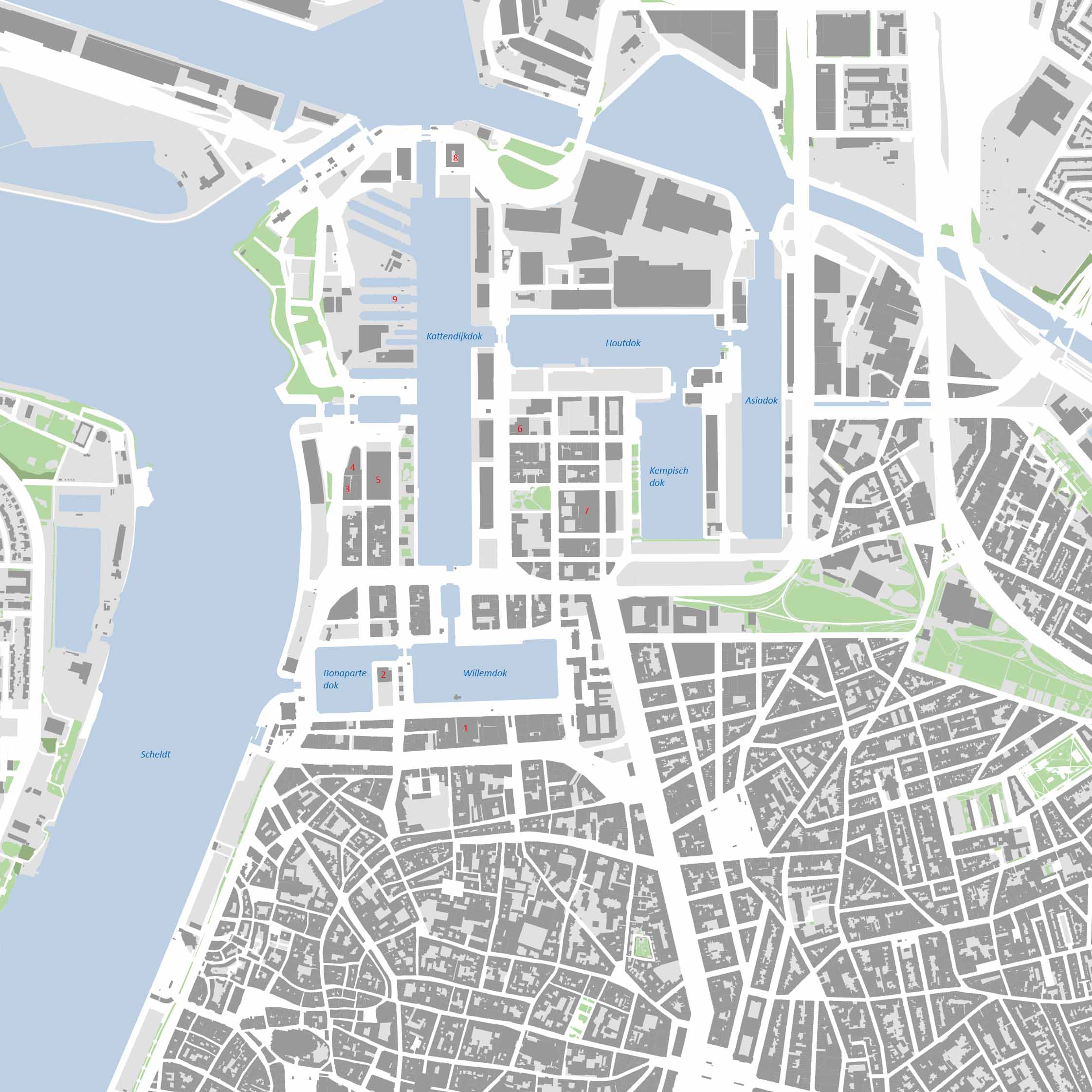
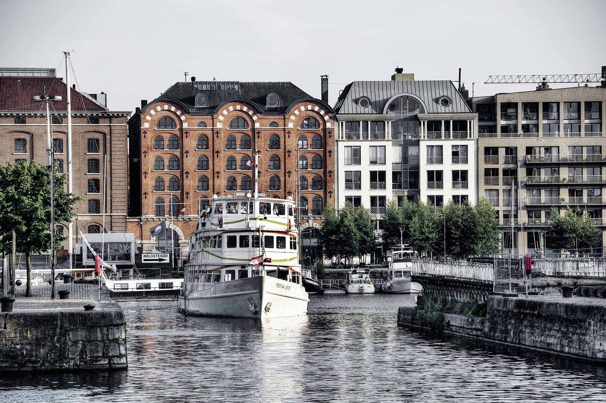
The construction of the two oldest port docks, at the initiative of Napoleon Bonaparte in 1811, is without a doubt the most important starting point, to which Het Eilandje owes its origin. These docks were situated in Nieuwstad, which was contained within the sixteenth-century city walls. The present-day Bonapartedok and Willemdok was the beating heart of Antwerp’s port, along with the harbour along the River Scheldt (following image). In the following decades, the area’s economic importance contributed to its development into a flourishing port-industrial neighbourhood. The Dutch period (1815-1830) and the Belgian period (from 1830) were periods of economic prosperity, during which the industrialisation of the European continent also had an impact on Antwerp.
In the 19th century, Antwerp’s economic success prompted the development of port infrastructure, outside the city walls. Plans were made to build a new dock outside the city walls and in 1856, King Leopold I attended the stone-laying ceremony for Kattendijkdok. Around 1860, the old city walls were demolished, connecting the new dock with the docks in the city. New city walls ensured that the entire port area was now situated within the city’s safe perimeter. New streets were built and social and economic infrastructure added. During the last quarter of the 19th century the construction of three additional docks, to the east of Kattendijkdok, created the current shape of Het Eilandje as we know it.
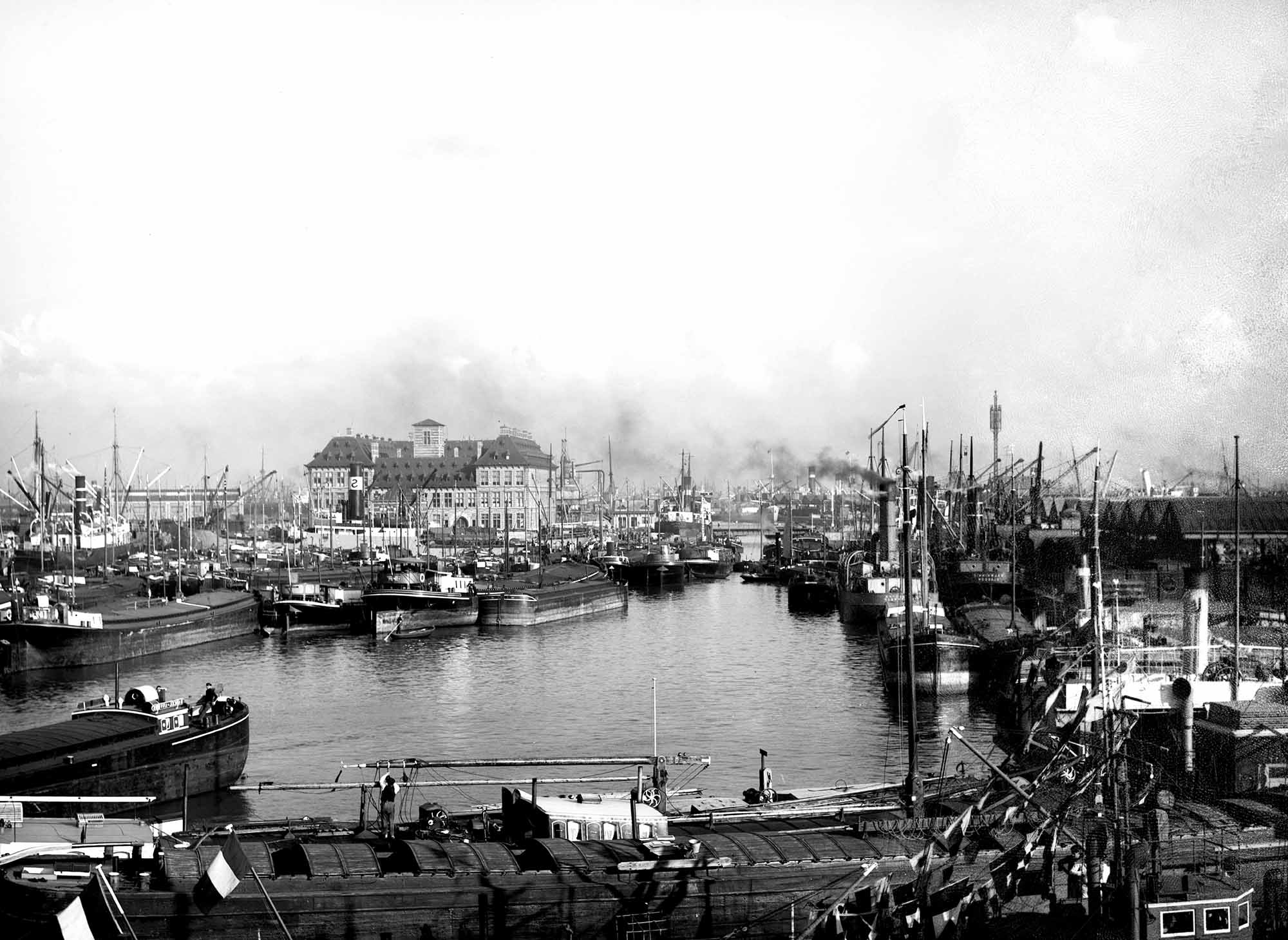
Along the docks, sheds were built, where goods could be transhipped for processing and transportation to the hinterland. The former Hanseatic House between Bonapartedok and Willemdok was converted into a grain warehouse but was destroyed in a fire in 1897 (Image_02). A hydroelectric plant, called the Noorderpershuis, was built to supply the energy needed to operate bridges, locks and cranes. Social amenities, including soup kitchens and bath houses, were established, to improve the quality of life of the dock workers. In addition to a cargo hub, Antwerp also became a hub for trans-Atlantic migrant traffic. From the end of the 19th century until the 1920s, just under two million people left for America or Canada on the ships of the Red Star Line, in hopes of a better future.
During World War I and II, the strategic importance of Antwerp’s port, for the warring parties, ensured that it remained almost intact. During the post-war period, business continued as usual and Het Eilandje prospered for several decades. Ultimately the port’s expansion to the north heralded its demise.
The first steps towards redevelopment
During the last decades of the 20th century, Het Eilandje became less interesting from an economic perspective, giving rise to the neighbourhood’s deterioration. The city soon realised that a new future needed to be mapped out urgently for this area. In 1987, Het Eilandje was designated a reconversion area, as part of the large-scale ‘Stad aan de Stroom’ urban planning project.
An international ideas competition was organised, with planners drawing up visionary plans for the new urban future of this historic city port. Stad aan de Stroom was based on a very participatory process. The wider dialogue of Stad aan de Stroom revealed the pride Antwerpers felt with regard to Het Eilandje and the quays. The population was very much aware of the famous past of this run-down port neighbourhood. At the same time, they also indicated that the time had come for change and innovation.
This dual conclusion was also reflected in the planning. The master plan of Manuel de Solà-Morales purposefully ‘hesitated’ between the past and the future. Using strategic interventions, it focused on renovation of the existing fabric and new additions, with almost surgical precision. Cultural stepping stones, such as the Felix Archives, the Museum aan de Stroom (MAS) and the Red Star Line Museum, established a mental connection between the city centre and Het Eilandje (the so-called cultural axis).
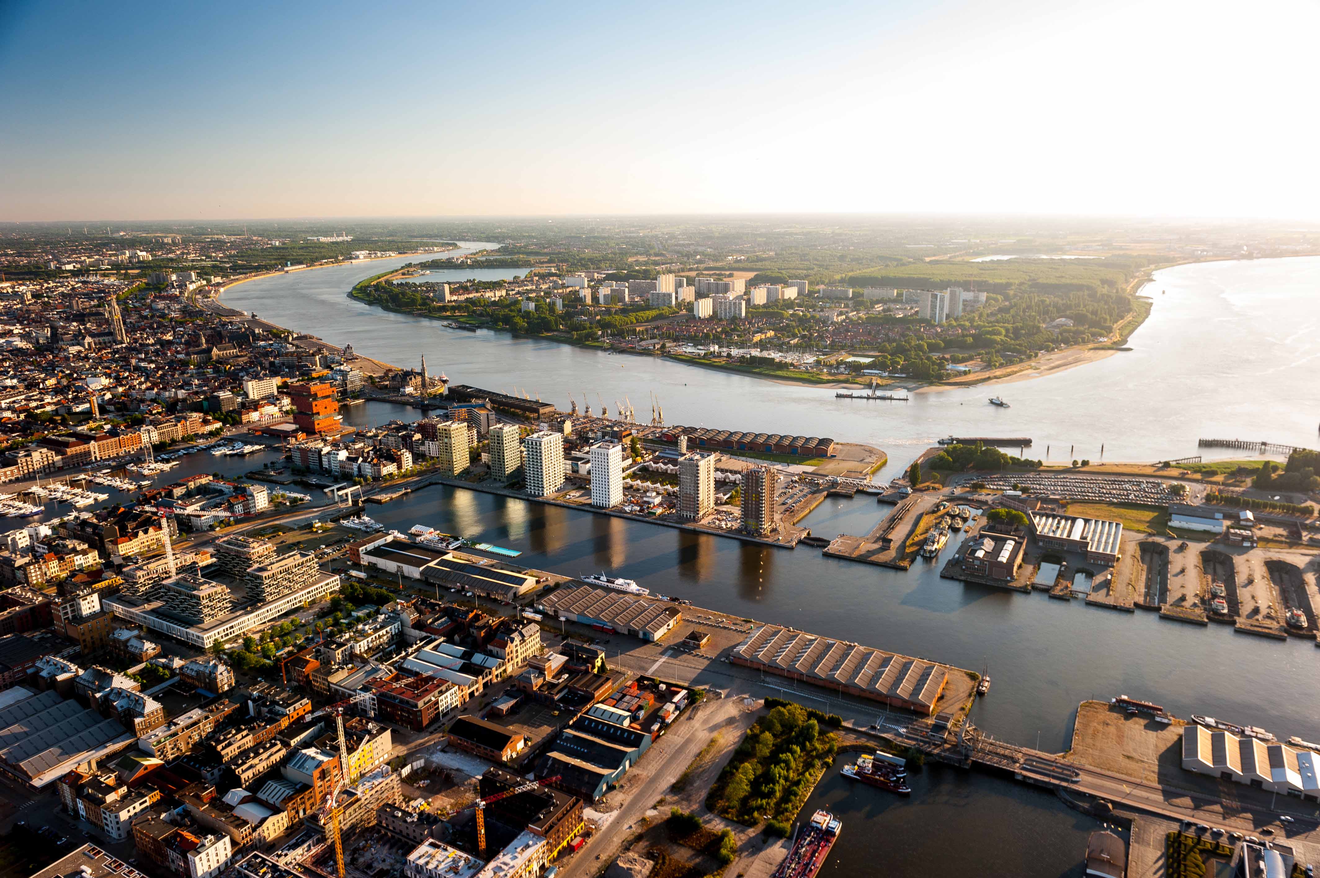
In 2000, the city architect (stadsbouwmeester) René Daniëls (Buro 5 Maastricht) fine-tuned the master plan, launching flagship projects in a close collaboration between the public and private sector (PPPs), which spurred the neighbourhood’s development and accentuated Het Eilandje’s historic identity and the heritage buildings. Specific rules were set out in Visual Quality Plans, such as the Architecture Paper, which evaluated the heritage and defined new architecture as the new warehouses of Het Eilandje. The Visual Quality Plan for public space also focused on the mix between the old and the new (‘no future without the past’). Quay walls, bridges and cranes were renovated, the old docks reinvented as ‘new’ squares while the sweeping quay plains were kept open where possible and planted with greenery (following image).
Protect to develop
Het Eilandje’s physical appearance is the outcome of many centuries of living and working in this neighbourhood. The dynamic of the surroundings is very strong, in an environment that is very driven by economic activities, such as a port area. The area thus quickly adjusts to new challenges or conditions. When the port activity disappears, the necessity of several relics, that are (in)directly linked to this activity, is suddenly questioned. At the same time, the formulation of a new perspective for Het Eilandje’s development also directed attention to the port industrial heritage in the neighbourhood.
Often the patrimony’s architectural value is only secondary and the historic or social-economic value is more important. The support for vernacular architecture or intangible values is often smaller than for buildings with architectural value. At the same time, these values define Het Eilandje’s DNA.
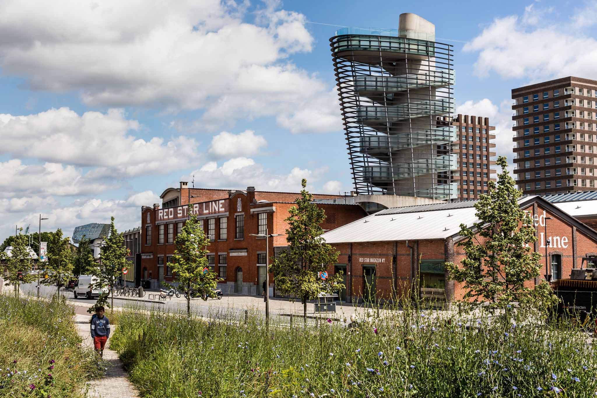
To guarantee the embedding of heritage as an underlay for the entire area, a rigorous selection was made of heritage relics that could be listed as monuments. This was a two-phase process. The first phase took place in 2001, followed by an additional series of listings in 2005. These buildings were listed based on a geographic/thematic premise. The wet infrastructure in the area was the first priority: the docks (the dock walls were listed), the dry docks, bridges and locks. A second cluster comprised the supporting infrastructure, which facilitated the operation of this port area: port sheds, warehouses, the Noorderpershuis (hydroelectric plant). A unique collection of old port cranes was assembled in Rijnkaai in recent years. Finally, a group of buildings was also listed as monuments, because of their social-historic value. They include Het Kot and De Shop, which were both built as places to recruit dock workers, as well as the shelter in Londenstraat for dock workers. A unique ensemble, in the listed patrimony of Het Eilandje, is formed by the original buildings of the Red Star Line. A museum on the theme of migration opened here in 2013 (following image).
The Visual Quality Plan from 2004 – or Architecture Paper – does not merely focus on listed architectural relics or relics to be protected. It also provides an inventory of iconic buildings, which help define the historic character of Het Eilandje. It distinguishes between buildings which have iconic status because of their context or others that have a special significance because of their typology. The Visual Quality Plan thus also drew attention to heritage as a driver for redevelopment. On the whole, heritage provides an incentive and is not experienced as restrictive. However, as with every historic context, the tension between conservation and development gives rise to important challenges on Het Eilandje.
The current spatial policy
In the early days, a lot of energy was expended on the development of a legal and organisation framework, partnerships, multiannual planning frameworks and finding funding. As a result, the redevelopment of Het Eilandje became a hugely complicated process during the first half of the last decade, undermining the trust of locals and the private investors. The stone-laying ceremony of the MAS Museum in September 2006 provided the much-needed breakthrough, rekindling the belief in progress of the heyday of ‘Stad aan de Stroom’ and boosting real estate development in the neighbourhood (following image). From then on, the warehouses were renovated one by one and new-build projects in a warehouse style sprung up all over the area.
The fact that the city and the port have continued to invest in the restoration of maritime infrastructure, including a lot of listed heritage buildings, such as warehouses, sheds, quay walls, cranes and bridges, is a crucial factor. The plans for Het Eilandje, which consist of a master plan, Visual Quality Plans, action plans, a Spatial Implementation Plan and the selection as a strategic programme within the city’s structural vision, provides a flexible framework for its redevelopment. As our insights change, there may also be shifts in emphasis. The planners are continuously zooming in and out on various scale levels. The strategic vision has an impact both on the level of the urban neighbourhood, as well as on the level of the buildings and public space. Vice versa, every specific project serves as a touchstone, to test whether the overall vision is sound. As such, the reworked Spatial Implementation Plan for Het Eilandje, which dates from 2011, anticipates on the disappearance of several iconic buildings in Het Eilandje. Building developers are now required to draw up a cultural-historic report and submit it for evaluation to the city’s Heritage department.
But these changes in emphasis are not just inspired by the aforementioned planning changes. The economic crisis also had an impact on Het Eilandje’s development, albeit it a positive one. In fact, it proved a blessing rather than a burden. Thanks to the crisis, the neighbourhood was able to catch its breath. The redevelopment of such a historic port area takes time. Small-scale, iconic buildings were often replaced with larger, new projects during the building boom. We refer to ‘slow urbanism’, because the building boom suddenly slowed down, creating a better mix between the old and the new.
The redevelopment of Het Eilandje has taken years to come to fruition. The time frame between the plans and the execution, or the interim period, is used to already create encounters between the existing and new users/residents of this neighbourhood. The emphasis has also shifted somewhat from the Old Docks and the cultural axis, which tends to be in the spotlight anyway during major events. Oral and written reactions attest to the pride visitors feel when they go to Het Eilandje. And the locals who live in this old port neighbourhood are even prouder. The population growth of recent years has led to the development of a critical mass, which takes the initiative to organise community events. New residents and users of this area are gradually developing an awareness of the neighbourhood’s identity.
In the future, the city will continue to focus on the development of Het Eilandje to the north of Londenstraat/Amsterdamstraat, finishing the Montevideo neighbourhood, building the Droogdokkenpark in the bend of the river Scheldt and developing the Cadix neighbourhood in a phased manner. The first steps have also been taken to develop a maritime museum next to the Dry Docks, where the Kogge, a medieval ship that was found nearby Doel, will be on display.
Challenges and perspectives
Whereas the preserved port-industrial buildings in Het Eilandje often have rather limited architectural value or a generic typology, the adequate redevelopment of these buildings continues to be quite a challenge, often because of their scale. The redevelopment of the Montevideo warehouses, which has proven to be a complicated process, is a good example. Although the first plans for the redevelopment of this (listed) building date from 2004, the building is still awaiting its reconversion. The transformation was successful in other cases however. De Shop in Rijnkaai, for example, was transformed into a multipurpose events hall with catering facilities. A large part of Het Kot near Kempisch Dok has since been integrated in the extension of a school campus.
The neighbourhood’s port-industrial heritage requires structural maintenance, for which sufficient financial resources should be made available. As these relics are often owned by the public authorities, and have a very limited or even no financial return, it is very difficult to find the budget for this, despite the financial grants which the Government of Flanders provides for the conservation and restoration of listed monuments.
The area’s patrimony of private dwellings is the Achilles heel in the preservation of Het Eilandje’s unique character. The unique mix of dwellings and industrial heritage is an important characteristic of this part of the city. But there is also a lot of pressure to scale up. On the one hand, the quality of the dwellings here is not such that it needs to be preserved at all cost. The current real estate market, however, is forcing a scale-up, inspired by profit, thereby putting substantial pressure on the original – largely 19th century – small-scale buildings in this neighbourhood.
At the same time, the pioneering role the government played, by cherishing this heritage, has also inspired private initiatives. A breakthrough is expected shortly for the reconversion of the Montevideo warehouses. The restoration and expansion of the municipal secondary school in Cadixstraat, another listed monument, will also have a positive impact on the surrounding neighbourhood. The mixed-use development in Het Eilandje also provides a fertile breeding ground for a varied approach to heritage. It is easier to retain the smaller, iconic and historic buildings in the narrower inner streets of the Montevideo neighbourhood, for example. The urban development process on Het Eilandje, which swings like a pendulum between the past and the future, thus takes the form of a continuous quest to strike a balance between conservation and innovation. Ready-made regulations will not be sufficient. The dialogue that is being established in a quality chamber such as the Antwerp building aesthetics committee, which focuses on a custom approach and an area-oriented, qualitative evaluation of each project, has proven helpful in the discussion.
The lessons we learnt from this urban renewal project inspired other developments, elsewhere in the city. The importance of continuing to build on the identity of every neighbourhood and the role of heritage in this process is now a starting premise for every project. The different layers of the past, which define Antwerp’s identity, act as a foundation for future-proof urban development. We have embedded this insight in the new Strategic Spatial Structure Plan that we are currently preparing. By cherishing the identity of every neighbourhood, we also define its liveliness. A diligent approach to heritage is a basic starting premise in this process.
References
Viganò, P. & Secchi, B. (2009), Antwerp. Territory of a new modernity, SUN, Amsterdam.
Vanreusel, J. (ed.) (1990), Antwerpen Ontwerpen, Blondé Artprinting International in cooperation with Stad aan de Stroom, Antwerpen.
Smits, F. & Verbeke, L. (2011), Het Eilandje. Urban renewal towards a dynamic neighbourhood by the water, Antwerpen.
Van Assche, J., Block, T. (ed.) (2011), Handboek voor waterfrontontwikkeling in kleine en middelgrote steden, ROI, Gent.
Lorquet, A. (2016), Antwerpen, stad van morgen: de vernieuwing van de stadsvernieuwing, Stad Antwerpen, Antwerpen.
Visual quality plans Eilandje, website complexe stadsprojecten, http://www.complexestadsprojecten.be/Paginas/Antwerpen_eilandje.aspx.