Saemangeum, on the coast of the Yellow Sea becomes the port city of Ariul, an economic and multifunctional new hub of Northeast Asia. Saemangeum will be renamed Ariul, “ari” meaning “water” and “ul” meaning “fence or base.” The name, which translates to “city of water,” a city to Korea poised to play an important role in the 21st century.
The government expects in fact that the estuarine area will become a global green waterfront city, an economic and multifunctional hub of Northeast Asia consisting of industrial-related facilities, global business hub, renewable energy-related businesses, scientific research centers, advanced agricultural clusters, tourist attractions, hotels, resorts and residential property, and ecological reserves.
Planned to be built upon a massive plot of reclaimed land along the Central West coast of South Korea, the Saemangeum Development Project is a state-generated construction master plan to build a global and multifunctional green city. The project, which has experienced many difficulties, will finally materialize with an investment of $2.1 billion; the new program which has already been implemented will become more flexible and will be completed in 2030.
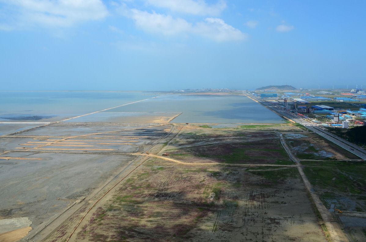 An aerial view of the Saemangeum area on the coast of the Yellow Sea.
The first step in the creation of 283 kmq of reclaimed land and a lake as large as 118 kmq by constructing the world’s longest sea dike at 33.9 kilometers, which connects Gunsan and Buan, west coast of Korea, was completed on April 27, 2010.
The average width of Saemangeum Seawall is 290 m (it is 535 m at its widest), and the average height is 36 m (54 m at its highest). At the top of the seawall is a four-lane road, along with parking lots, rest areas, a green zone and observatory decks. In the 15 months since its completion, Saemangeum Seawall has been visited by 10 million tourists. This is in fact an unprecedented project.
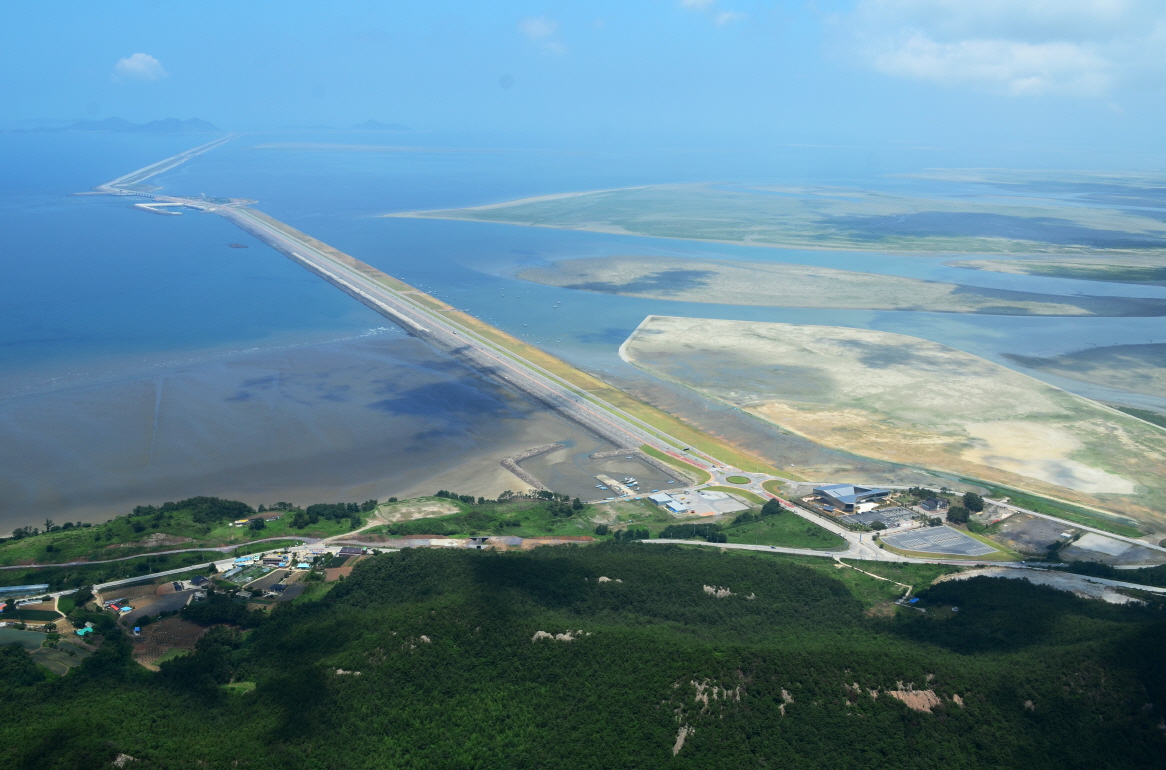 The Saemangeum Seawal which connects Gunsan and Buan, west coast of Korea.
Saemangeum will be able to accommodate 760,000 residents on a 401-square-kilometer, and aims at becoming an multifunctional and environmentally friendly city.
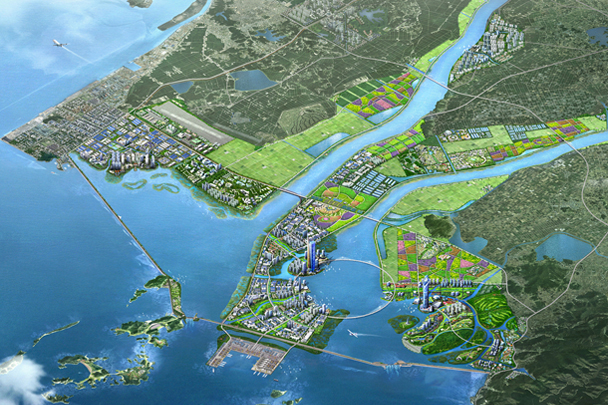 The new city on the water of Saemangeum. (Image: https://www.isaemangeum.co.kr, © KRC Saemangeum Project Office)
The Korean government is planning to divide a total area of 28,300 ha into 8 different areas, including an industrial area, a multifunctional city, a seawall and multifunctional site, a farming area, an ecological/environmental area, a scientific/research area, and a new renewable energy.
Farmland represents the largest part, 85.7 kmq (30.3%) of 282.9 kmq of the Saemangeum area. The built-up land area except transportation and utilities is 65.2 kmq representing 23% of the whole area. In detail, it consists of 18.1 kmq of industrial area, 17.3 kmq for tourism and leisure, 12.3 kmq for research and development, 12.9 kmq for residential areas, and 4.6 kmq for commercial and business purposes.
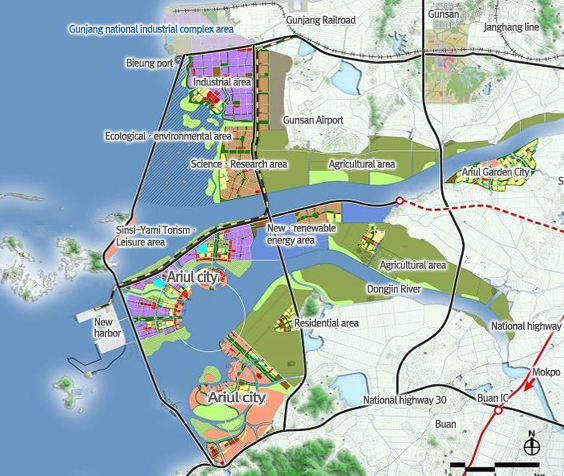 Plan for Ariul land use and infrastructure. (Image: https://www.isaemangeum.co.kr, © KRC Saemangeum Project Office)
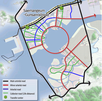
The multifunctional city of Ariul will mainly follow the “radiator-type structure (Sha-Ring) with the circle in the central area as the core function.
The transportation infrastructure will be further developed to make Saemangeum easily accessible by international airport and sea ports, the national highway and the high speed train connection.
Will be made new urban axis to connect the north industrial complex to the global business and tourism districts in Ariul city, industrial and cultural functions in the urban areas of Jeonju to the residential, industry and logistics functions of Saemangeum, and the sea dike to wetland and ecological environmental zones of Gunsan and Byunsan areas.
Will be built a circulation loop a inner circulation ring linking three major city cores (radius 2.4 Km length 15.2 Km) and five minor arterial roads with the principal arterial roads.
Will be identified two stations at the double track electric railroad as transit centers that allow for the use of other means of transportation and logistics services, and introduced bimodal tram in Ariul city center.

With the aim of creating an ecological network connecting estuaries, environmental zones and waterfronts, the project also includes the construction of bike and pedestrian way and a system of water transport and the construction of a transit terminal for waterbus and watertaxi served by three stations in Ariul city center. Finally, seven intermodal hubs will allow the connection of the regional transportation system with the inner transportation system.
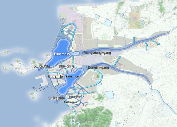 The ecological blue network connecting estuaries, environmental zones and waterfronts. (Image: https://www.isaemangeum.co.kr, © KRC Saemangeum Project Office)
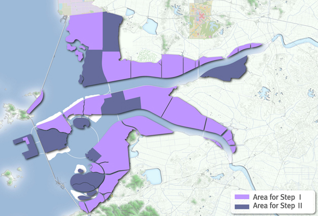
The first phase of the project will be carried out by 2020, and the second phase starts in 2021, with 72.7% (205.8sqkm) of the total area developed in the first phase. The city will be divided into northern and southern parts. The northern half will be developed as an industrial city, commerce and residence, while the southern half will focus on tourism, with facilities like a Korean culture theme park, marine sports facilities and resorts. As for the new renewable energy area, Samsung will establish a green energy industrial complex.
 The project development plan for next steps. (Image: https://www.isaemangeum.co.kr, © KRC Saemangeum Project Office)
Additionally, by 2017 the breakwater, the multifunctional land and other construction sites will be developed as a “mega resort”(1.95 kmq) where people can fully enjoy nature, connecting Simsido and Yamido islands in the middle of Saemangeum Seawall. A hotel, commercial facility, convention center, medical center and water park will also be built to utilize resources of Gogunsan Archipelago to meet the demands of tourists.
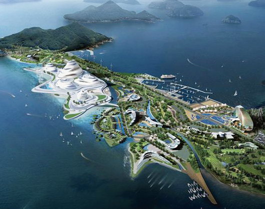 The Ariul mega resort in the Gogunsan Archipelago. (Image: https://www.isaemangeum.co.kr, © KRC Saemangeum Project Office)
A crucial part of the Saemangeum Development Project, the development harbor program consists of the construction of a 3.5-kilometer seawall, a 4.1-kilometer pier.
As an initial step, the government plans to finish the construction of a 3.1-kilometer pier and four berth container ports by 2020.
Once completed, the new port, located 280 kilometers south of Seoul, will be able to handle 17.29 million tons of freight per year. Development of tourist sites and recreational facilities will also be carried out on the sidelines of the project.
Additionally, the land site of 4,500 ha (18.9%), for which there is no demand in the short-term, will be designated as a “reserved area” so that it can be used and managed for the moment as agricultural land and in the future as areas for the development of port activities.
 The Ariul new port, located 280 kilometers south of Seoul. (Image: https://www.isaemangeum.co.kr, © KRC Saemangeum Project Office)
Ariul una nuova città sull’acqua. Saemangeum, Sud Corea
Saemangeum, sulla costa del Mar Giallo diventa la città-porto di Ariul, un nuovo centro economico e multifunzionale del Nord-est asiatico. Saemangeum verrà rinominato Ariul, “ari” che significa “acqua” e “ul” che significa “recinto o base” Il significato del nome, che si traduce in “città d’acqua”, una città in Corea pronta a svolgere un ruolo importante nel XXI secolo.
Il governo auspica infatti che la zona dell’estuario possa diventare una città d’acqua internazionale e sostenibile, un polo economico e multifunzionale del Nord-Est asiatico caratterizzato dalla presenza di impianti industriali, poli internazionali del business, imprese che operano nel settore delle energie rinnovabili, centri della ricerca scientifica, cluster agri-culturali avanzati, attrazioni turistiche, hotel, resort e insediamenti residenziali, riserve ecologiche.
Pianificato per essere costruito su una vasta estensione di terreni bonificati sulla costa centro-occidentale della Corea del Sud – il Saemangeum Development Project è un masterplan ad opera dello Stato elaborato per realizzare una green city globale e multifunzionale.
Il progetto, che ha conosciuto diverse difficoltà, sarà realizzato con un investimento di $2.1 billion; il nuovo programma che è stato elaborato sarà reso più flessibile e completato nel 2030.Una veduta dall’alto dell’area di Saemangeum sulla costa del Mar Giallo.
La prima fase prevede il recupero di 283 kmq di terre bonificate e la creazione di un grande lago, ampio 118 kmq, attraverso la costruzione della maggiore diga marittima al mondo, lunga 33,9 km, che collega Gunsan a Buan, sulla costa ovest della Corea, inaugurata il 27 aprile 2010.
La larghezza media della Saemangeum Seawall è di 290 m (535 m è la larghezza maggiore), e l’altezza media è di 36 m (54 m l’altezza massima). Sulla parte superiore della diga corre una strada a quattro corsie, dotata di parcheggi, aree di sosta, una zona verde e punti di osservazione. Nei 15 mesi successivi al suo completamento, la Saemangeum Seawall è stata visitata da 10 milioni di turisti. Si tratta infatti di un progetto senza precedenti.La diga di Saemangeum che connette Gunsan e Buan sulla costa est della Korea.
Saemangeum sarà in grado di accogliere 760.000 residenti su 401 kmq, e punta a diventare una città multifunzionale e rispettosa dell’ambiente.La nuova città d’acqua di Saemangeum. (Immagine: https://www.isaemangeum.co.kr, © KRC Saemangeum Project Office)
Il governo coreano prevede di suddividere la superficie complessiva di 28,300 ettari in 8 ambiti differenti, tra cui una zona industriale, una città multifunzionale, una diga e un sito multifunzionale, una zona agricola, un’area ecologico-ambientale, un polo scientifico e della ricerca, e un centro per la nuova energia rinnovabile.
L’area agricola rappresenta l’ambito maggiore con 85,7 kmq (30,3%) dei 282,9 kmq dell’area di Saemangeum. La superficie costruita ad eccezione del trasporto e dei servizi pubblici si estende su 65,2 kmq e rappresenta il 23% dell’intera area. In particolare, si compone di 18,1 kmq di superfici industriali, 17,3 kmq destinati al turismo e al tempo libero, 12,3 kmq per la ricerca e lo sviluppo, 12,9 kmq per insediamenti residenziali, e infine 4,6 kmq per fini commerciali e di business.Il piano delle destinazioni funzionali e delle infrastrutture di Ariul. (Immagine: https://www.isaemangeum.co.kr, © KRC Saemangeum Project Office)
La città multifunzionale di Ariul seguirà principalmente un tipo di struttura radiale (Sha-Ring) con un cerchio nella zona centrale, come cuore funzionale.
Le infrastrutture di trasporto saranno ulteriormente sviluppate in modo da rendere Saemangeum facilmente raggiungibile dall’aeroporto internazionale e dai porti marittimi, mediante strade statali e collegamenti ferroviari ad alta velocità.
Sarà realizzato un nuovo asse urbano per collegare il complesso industriale a nord con i distretti terziari e turistici della città di Ariul, le funzioni industriali e culturali nelle aree urbane di Jeonju alle funzioni residenziali, industriali e logistiche di Saemangeum, e la diga a mare con le zone umide e con le aree ambientali ed ecologiche di Gunsan e Byunsan.
Sarà costruito inoltre un anello di circolazione interna per collegare i tre principali nuclei della città (2,4 km di raggio e 15,2 km di lunghezza) e cinque arterie minori con le principali arterie stradali.
Saranno identificate due stazioni per linee ferroviarie elettriche a doppio binario che diventeranno centri di transito per consentire l’interscambio con altri mezzi del sistema di trasporto e della logistica, e con il tram bimodale introdotto nella centro urbano di Ariul.
Le infrastrutture di trasporto e il traffico acqueo. (Immagine: https://www.isaemangeum.co.kr, © KRC Saemangeum Project Office)
Con l’obiettivo di creare una rete ecologica di connessione tra estuari, zone ambientali e waterfront, il progetto prevede inoltre la costruzione di un sistema di trasporto sull’acqua e la costruzione di un terminal di transito per waterbus e taxi acquei servito da tre stazioni nella centro urbano di Ariul. Infine, sette hub intermodali consentiranno la connessione del sistema di trasporto regionale con il sistema di trasporto interno.La rete ecologica blu che connette estuary, zone ambientali e waterfront. (Immagine: https://www.isaemangeum.co.kr, © KRC Saemangeum Project Office)
La prima fase del progetto sarà realizzata entro il 2020, e la seconda fase inizierà nel 2021, con il 72,7% (205.8 sqkm) della superficie totale sviluppata nella prima fase. La città sarà divisa in parte settentrionale e meridionale. La metà a nord sarà sviluppato come una città industriale, del commercio e della residenza, mentre la metà a sud sarà dedicata al settore turistico, con strutture come un parco a tema dedicato alla cultura coreana, installazioni per sport nautici e resort. Per quanto riguarda la nuova area delle energie rinnovabili, Samsung insedierà qui un complesso per l’energia verde industriale.Il piano di sviluppo del progetto per fasi successive. (Immagine: https://www.isaemangeum.co.kr, © KRC Saemangeum Project Office)
Inoltre, entro il 2017 la diga, il territorio multifunzionale e altri siti in costruzione saranno sviluppati come “mega resort” (1.95 kmq) dove le persone potranno godere appieno della natura, del collegamento con Simsido e delle isole Yamido prossime alla Saemangeum Seawall. Saranno realizzati inoltre un hotel, un complesso commerciale, un centro congressi, un polo sanitario e un parco acquatico per utilizzare le risorse dell’arcipelago di Gogunsan in modo da soddisfare la domanda turistica.Il mega resort di Sriul nell’arcipelago di Gogunsan. (Immagine: https://www.isaemangeum.co.kr, © KRC Saemangeum Project Office)
Una parte fondamentale del Saemangeum Development Project, il programma per lo sviluppo del porto consiste nella costruzione di una diga di 3,5 km e di un molo di 4,1 km.
Per la fase iniziale, il piano del governo prevede il completamento della costruzione di 3,1 km di molo e di quattro ormeggi per portacontainer entro il 2020.
Una volta completato, il nuovo porto, che si trova 280 chilometri a sud di Seoul, sarà possibile gestire 17.290.000 di tonnellate di merci all’anno. A margine del progetto saranno inoltre sviluppati siti turistici e strutture ricreative.
Inoltre, 4.500 ettari (18,9%) di terreno in assenza di un’offerta a breve termine, verranno destinati come “area riservata” in modo che possano essere utilizzati e gestiti per il momento come terreni agricoli ed in futuro come aree per lo sviluppo delle attività portuali.Il nuovo porto di Ariul, situate 280 km a sud di Seoul. (Immagine: https://www.isaemangeum.co.kr, © KRC Saemangeum Project Office)