Surprisingly, the analysis of port cities based on their maritime linkages is a new perspective in urban and transport studies. The World Seastems [1] project tackled this challenge by assembling 120 years of urban population and maritime traffic data for more than 3,000 cities across the world, between 1890 and 2010 [2]. It aims to reveal how much maritime flows are tied to urban places in various ways, to test the widely accepted idea that ports and cities have evolved from synergy to separation in the past decades.
The main effort of this study has been put on the assignment of ports to urban areas, and to harmonize dispersed population databases across this vast period. No less than 769,272 vessel movements among cities were extracted and compiled from the Lloyd’s Shipping Index. The idea of this research note is to retain the most salient lessons brought by the crossing of these two dimensions, urban and maritime, shedding new light on the following questions: how have global maritime flows been correlated with city size? Are larger cities dominant in the maritime network?
Traffic distribution
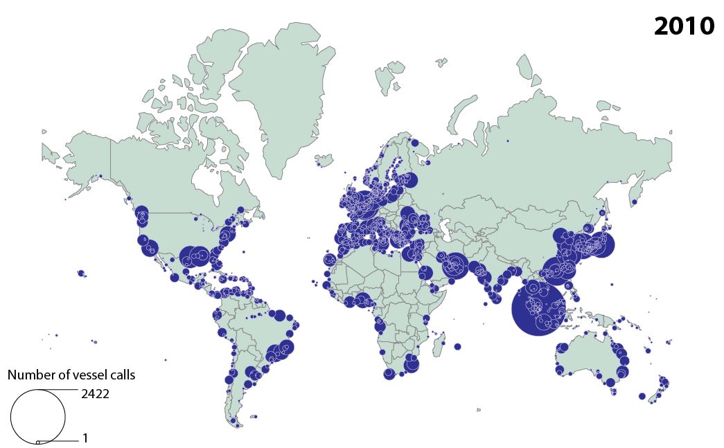
Mapping the number vessel calls per city in the world (Figure 1) provides a first snapshot of maritime traffic distribution, allowing to identify areas of traffic concentration and major geographic shifts. Once classified among 6 groups of demographic size, it appeared that the group of the demographically largest cities clearly concentrated an overwhelming share of global maritime traffic, i.e. 70% on average between 1890 and 2010. Yet, this share dropped from 69.7% to 60.5% in 2010, due to the growth of smaller cities. New bulk or container ports indeed were often developed outside cities, to benefit from better nautical accessibility while relieving large cities from lack of space and congestion.

The linear correlation between maritime traffic and urban population confirms this trend, with a regular drop from 0.66 in 1925 to 0.28 in 2010. It means that traffic and population had become less overlapped in space and time, for the same reasons given above. When assigning the same traffic to distant coastal or inland cities, however, the same correlation increased from 0.29 in 1925 to 0.63 in 2010. This suggest that ports and cities are still tied to each other in similar ways than in the past, but at the expense of their physical proximity, given the rise of road transport distances between them.
When classified by location type, we observed that upstream (river or delta) port cities witnessed the biggest correlation drop, from 0.78 in 1890 to 0.19 in 2010, while inland (non-port) cities increased from 0.11 to 0.92. Upstream cities became increasingly constrained for receiving ships of ever bigger size and draft, while inland cities could connect maritime flows through distant but well-connected terminals.
Traffic specialization
The nature of ships calling at port cities is another way to look at such dynamics. In the early period (1890-1925), steamer vessel traffic enjoyed a much higher correlation with city size than sailing vessel traffic (0.66 against 0.44 on average). Not only larger cities concentrate the most advanced shipping technology at the time, but also, they always handle a wider traffic mix than smaller cities. London and New York for instance were early adopters of steam technology while maintaining the more traditional sailing traffic.
In the more recent period (1975-2010), a similar trend can be observed, as the largest cities are always more diversified than smaller cities, based on the distribution of general cargo, containers, solid bulk, liquid bulk, passengers, and vehicles. General cargo and containers, the most valued and employment-generative traffics, are better correlated with city size than the other traffic types. Thus, large (port) cities benefits from agglomeration economies and a more diversified economic base, which is reflected in their traffic structure.
Shipping distances and centrality
Maritime linkages can also be characterized by their kilometric length, measured in orthodromic distances. When distributed according to city size, again, the largest cities persistently exert longer-distance interactions than smaller cities. This became even truer when considering call-kilometers instead of sole physical distances.
The same phenomenon applies to maritime centrality scores. Systematically, larger cities perform better in the maritime network than smaller cities, whatever the retained measure: degree centrality (number of links), betweenness centrality (number of occurrences on shortest routes), eccentricity (topological proximity to all other nodes), and clustering coefficient (capacity to dominate neighbor nodes, or hub functions).
Port-city hubs
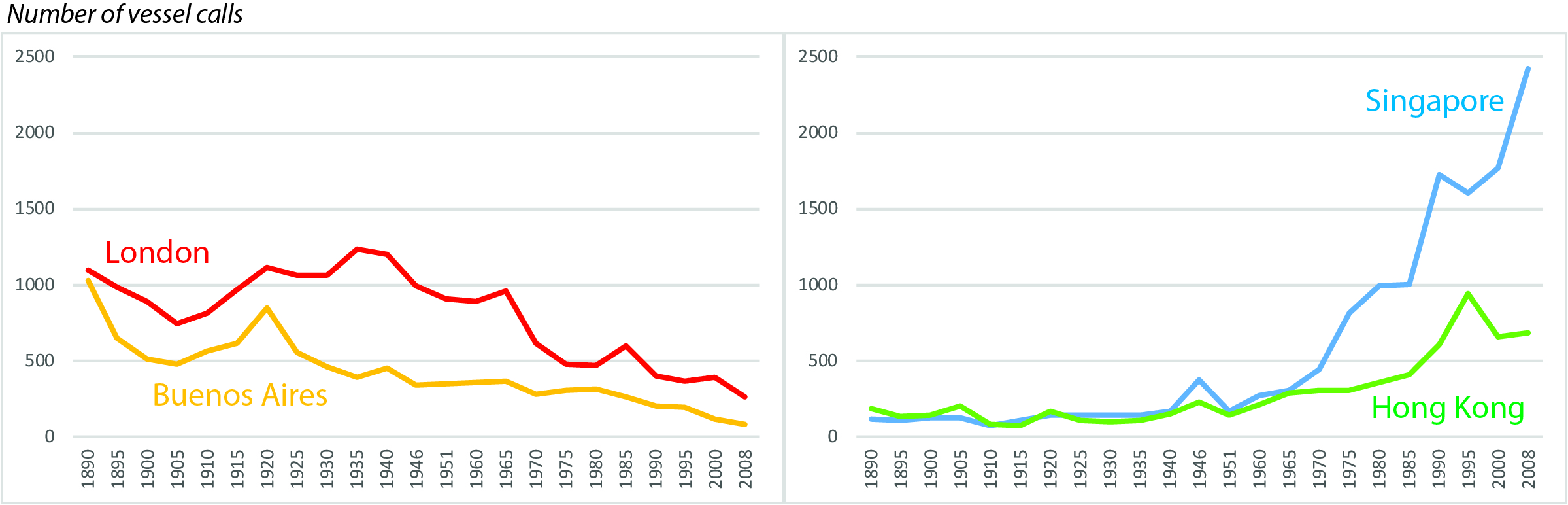
The identification of hubs in the global maritime network is where the most impressive changes are felt, thereby complementing the rather stable trends observed above. Five key dates are retained to describe the shifts in hub functions. In 1890 London and New York are both the largest port cities and the biggest maritime hubs, followed by well-populated nodes such as Buenos Aires, San Francisco, Liverpool, Hamburg, and Amsterdam. Those cities exert long-distance dominance on all continents through a colonial logic. In 1920, this system is reinforced, while in 1950, Tokyo emerges as an independent hub. This corresponds to nowadays global cities having reached unprecedented levels of economic development in a variety of sectors.
In 1980, London and New York are surpassed by large gateway port cities such as Rotterdam, Genoa, Hamburg, and Antwerp as pivotal hubs in the global system. Tokyo and Osaka dominate a larger portion of the network, while only a few large cities keep their secondary hub position, like Athens (Piraeus), Sao Paulo (Santos), and Lagos in Nigeria. The last stage in 2010 exhibits an extremely centralized system where Rotterdam and Singapore stand far beyond all other nodes by their well-developed centrality and dominance. Demographically larger cities have all become rather peripheral, connecting the rest of the world via transshipment hubs.
Conclusion
This study could positively answer our questions raised in the introduction, by the fact that contemporary maritime networks still remain, for a large part, well-articulated with the urban economies they connect. Larger cities have kept a relatively stable position in the maritime network, despite all the technological changes occurring from sail to steam and containers. Nevertheless, the spatial shift of many terminals outside cities, the growth of road transport connectivity, and the economic growth outside of the initially dominant North Atlantic region have had important effects on port-city linkages. If this quantitative exercise cannot document in detail particular trends affecting individual port cities, each of them being animated by a unique set of actors and histories, it allows us to offer a complementary perspective on the crucial issue of port-city development in the world.
Acknowledgements
The author would like to thank Liliane Lizzi at UMR Géographie-cités for her support on cartography, as well as Sylvain Cuyala and Ali El Hosni on the database elaboration. The research leading to these results has received funding from the European Research Council under the European Union’s Seventh Framework Programme (FP/2007-2013)/ERC Grant Agreement n. [313847] ‘World Seastems’.
Notes
[1] www.world-seastems.cnrs.fr
[2] This study extends an earlier paper focused on the 1950-1990 period, see: https://jshippingandtrade.springeropen.com/articles/10.1186/s41072-016-0006-2
Head image: A view of Singapore, the city and cargo container port.